
Image
Map of Daviess & Martin counties, Indiana Public Deposited
- Genre
- Geological maps
- Location
- Coordinates: W0871645 W0863823 N0385617 N0382924
- Related URL
- Abstract
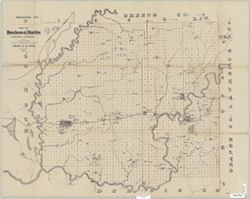
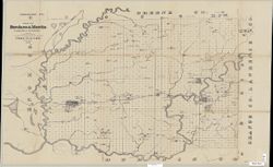
- Drawn by G.M. Levette for the second annual report of Prof. E.T. Cox, state geologist , [geology by John Collett]. Shows worked coal, coal outcrops, iron ore, sandstone, limestone, and mills. Shows worked coal, coal outcrops, iron ore, sandstone, limestone, and mills. Detached from: Second report of the Geological Survey of Indiana, made during the year 1870 ... / E.T. Cox. Indianapolis: R.J. Bright, 1871.
- Call Number
- G4093.D2H1 1870 .L4
- Caption
- Imprint: Indianapolis, Ind. : Geological Survey of Indiana, [1871]
- Filename
- VAC3073-M-01263
- Subject
- Topical Subject: IGS Annual Reports
- Topical Subject: Geology, Economic
- Geographic Subject: Daviess County (Ind.)
- Geographic Subject: Martin County (Ind.)
- Topical Subject: Mines and mineral resources
- Title
- Map of Daviess & Martin counties, Indiana
- Producer
- Collett, John, 1828-1899
- Levette, G. M. (Gilbert M.)
- Cox, E. T. (Edward Travers), 1821-1907
- Physical Description
- Scale: Approximately 1:85,000
- Dimensions: on sheet 63 x 79 cm
- Item Identifiers
- Alternate ID: 390721IP
- Title Control Number: a18282530
- Persistent Identifier
- Campus
- IU Bloomington
- Date Created
- 1871
- Provenance
- 2nd Annual Report (1870) / Indiana. Geological Survey.
- Publisher
- Indiana. Geological Survey
Relationships
Relationships
- In Collection:
Items
Show Item Images
| Thumbnail | Title | Date Uploaded | Visibility | Actions |
|---|---|---|---|---|
|
VAC3073-M-01263.jp2 | 2023-09-28 | Public |
|
|
VAC3073-00939.jp2 | 2023-09-28 | Public |
|