
Image
Illinois--Indiana Carmi quadrangle : 15-minute series Public Deposited
- Genre
- 15 minute topographic maps
- Quadrangle maps
- Topographic maps
- Location
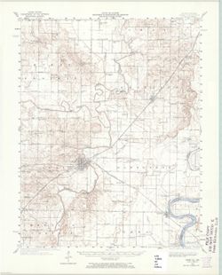
- Coordinates: W0881500 W0880000 N0381500 N0380000
- Related URL
- Abstract
- Topography by H. E. Simmons, J. C. Hilliard, A. T. Munson, E. W. Gouchenour, P. L. Sampson, A. W. Thomas, and F. W. Weber. ... Topography in Indiana from chart of the Wabash River by Corps of Engineers, U. S. Army. Variant title: Carmi quadrangle, Illinois--Indiana. Filing title: Carmi, Ill.--Ind. Standard map series designation: AMS (Series) V763 3360 II. Polyconic projection. Washington, D.C. : Interior--Geological Survey, 1965. Relief shown by contours and spot heights. Shows White County, Illinois, and small portion of Posey County, Indiana. Contour interval 10 feet. At head of map: State of Illinois, Department of Registration and Education, Geological Survey Division. Surveyed in 1921 and 1939-1940. "N3800--W8800/15." "AMS 3360 II-Series V763."
- Call Number
- G4090 s62 .G4 Carmi 1940 rep1965
- Caption
- Imprint: Washington, D.C. : The Survey, 1965.
- Filename
- VAC3073-M-01327
- Subject
- Geographic Subject: White County (Ill.)
- Geographic Subject: Posey County (Ind.)
- Title
- Illinois--Indiana Carmi quadrangle : 15-minute series
- Producer
- United States. Army. Corps of Engineers
- Geological Survey (U.S.)
- Physical Description
- Scale: 1:62,500
- Dimensions: 45 x 42 cm or smaller
- Item Identifiers
- Title Control Number: a18408709
- Persistent Identifier
- Campus
- IU Bloomington
- Date Created
- 1965
- Provenance
- Part of Geological Survey (U.S.). Indiana 1:62,500.
- Publisher
- Geological Survey (U.S.)
Relationships
Relationships
- In Collection:
Items
Show Item Images
| Thumbnail | Title | Date Uploaded | Visibility | Actions |
|---|---|---|---|---|
|
VAC3073-M-01327.jp2 | 2023-09-28 | Public |
|