
Image
Indiana-Illinois Patoka quadrangle [1921 reprint] 公开 Deposited
- Genre
- 30 minute topographic maps
- Topographic maps
- Quadrangle maps
- Location
- Coordinates: W0880000 W0873000 N0383000 N0380000
- Related URL
- Abstract
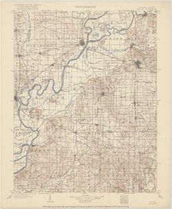
- Jno. H. Renshawe, geographer in charge , control by Geo. T. Hawkins , topography by Chas. W. Goodlove , engraved June 1903 by U.S.G.S. Relief shown by contours and spot heights. Contour interval 20 feet. Surveyed in 1901-1902. Shows portions of Gibson, Posey, and Vanderburgh counties in Indiana, as well as small portions of Knox County, Indiana, and White, Wabash, and Edwards counties in Illinois. Reprinted 1921.
- Call Number
- G4090 s125 .G4 Patoka 1903 rep1921
- Caption
- Imprint: [Washington, D.C.] : U.S. Geological Survey, 1921
- Filename
- VAC3073-M-01419
- Subject
- Geographic Subject: Posey County (Ind.)
- Geographic Subject: Gibson County (Ind.)
- Geographic Subject: White County (Ill.)
- Geographic Subject: Vanderburgh County (Ind.)
- Geographic Subject: Wabash County (Ill.)
- Geographic Subject: Edwards County (Ill.)
- Geographic Subject: Knox County (Ind.)
- Title
- Indiana-Illinois Patoka quadrangle [1921 reprint]
- Producer
- Hawkins, Geo. T. (George T.)
- Geological Survey (U.S.)
- Renshawe, John H.
- Goodlove, C. W.
- Physical Description
- Dimensions: 45 x 36 cm
- Scale: 1:125,000
- Item Identifiers
- Title Control Number: a18416043
- Persistent Identifier
- Campus
- IU Bloomington
- Date Created
- 1921
- Provenance
- Part of Geological Survey (U.S.). Indiana 1:125,000.
- Publisher
- Geological Survey (U.S.)
Relationships
关联
- 属于 Collection:
Items
Show Item Images
| 缩略图 | 标题 | 上传日期 | 公开度 | 行动 |
|---|---|---|---|---|
|
VAC3073-M-01419.jp2 | 2023-09-28 | 公开 |
|