
Image
Geologic map of the Knobstone Group, Indiana (New Albany sheet) Public Deposited
- Genre
- Geological maps
- Location
- Coordinates: W0863410 W0853500 N0390430 N0375720
- Related URL
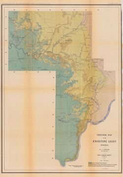
- Abstract
- Relief shown by contour lines. "Plate III." Detached from: A geologic and topographic section across Southern Indiana / by J. F. Newsom. In Indiana Department of Geology and Natural Resources twenty-sixth annual report ... 1901. Indianapolis : Wm. B. Burford, 1902. Page 260.
- Call Number
- G4091.C5 1901 .N43
- Caption
- Imprint: [Indianapolis, Ind.] : [Indiana Department of Geology and Natural Resources], [1901]
- Imprint: Indianapolis, Ind. : Wm. B. Burford, [1902]
- Filename
- VAC3073-M-00381
- Subject
- Topical Subject: Mines and mineral resources
- Topical Subject: Geology
- Geographic Subject: Indiana
- Topical Subject: Geology, Stratigraphic
- Topical Subject: Limestone
- Title
- Geologic map of the Knobstone Group, Indiana (New Albany sheet)
- Producer
- Newsom, John F. (John Flesher), 1869-1928
- Physical Description
- Scale: Scale approximately 1:190,080. 3 miles = 1 in.
- Dimensions: 69 x 49 cm, on sheet 76 x 52 cm
- Item Identifiers
- Title Control Number: a16077083
- Alternate ID: 390726IP
- Persistent Identifier
- Campus
- IU Bloomington
- Date Created
- 1902
- Provenance
- 26th Annual Report (1901) / Indiana. Department of Geology and Natural Resources.
- Publisher
- Indiana. Department of Geology and Natural Resources
Relationships
Relationships
- In Collection:
Items
Show Item Images
| Thumbnail | Title | Date Uploaded | Visibility | Actions |
|---|---|---|---|---|
|
VAC3073-00141.jp2 | 2023-09-25 | Public |
|