
Image
Morgan County, Ind. Public Deposited
- Genre
- Thematic maps
- Location
- Coordinates: W0864115 W0861459 N0393801 N0392017
- Related URL
- Abstract
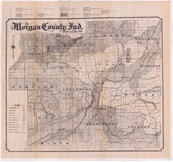
- Shows soil types, school houses, cemeteries, churches, railroads, county roads and township roads. Detached from: Soil survey of Morgan County / J.B. Edmondson. In Thirty-sixth annual report of Department of Geology and Natural Resources, Indiana, 1911. Indianapolis: Wm. B. Burford, 1912. Page 92.
- Call Number
- G4093.M9J3 1911 .E3
- Caption
- Imprint: [Indianapolis] : [Department of Geology and Natural Resources, Indiana], [1912] [Indianapolis] : [Wm. B. Burford], [1912]
- Filename
- VAC3073-M-01094
- Subject
- Topical Subject: Soils
- Geographic Subject: Morgan County (Ind.)
- Title
- Morgan County, Ind.
- Producer
- Edmonson, James Bartlett, 1882-1954
- Physical Description
- Scale: Approximately 1:63,360
- Dimensions: 52 x 61 cm
- Item Identifiers
- Alternate ID: 390726IP
- Title Control Number: a16096234
- Persistent Identifier
- Campus
- IU Bloomington
- Date Created
- 1912
- Provenance
- 36th Annual Report (1911) / Indiana. Department of Geology and Natural Resources.
- Publisher
- Indiana. Department of Geology and Natural Resources
Relationships
Relationships
- In Collection:
Items
Show Item Images
| Thumbnail | Title | Date Uploaded | Visibility | Actions |
|---|---|---|---|---|
|
VAC3073-00183.jp2 | 2023-09-27 | Public |
|