
Image
Soil map, Indiana, Adams County sheet Public Deposited
- Genre
- Thematic maps
- Location
- Coordinates: W0850400 W0844700 N0405700 N0403400
- Related URL
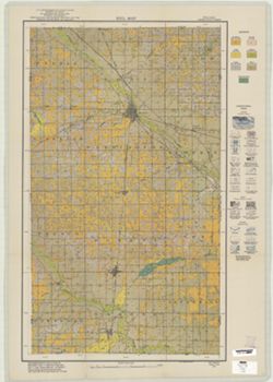
- Abstract
- Shows soil types classification by colors and symbols. Relief shown by contours and hachures. Soils surveyed by Grove B. Jones, Mark Baldwin, S.C. Jones, Thomas Jabine and T.M. Bushnell. "Field operations Bureau of Soils 1921.:
- Call Number
- G4093 .A2J3 1921 .J6
- Caption
- Imprint: [Washington, D.C.?] : The Bureau, [1921?]
- Filename
- VAC3073-M-00111
- Subject
- Topical Subject: Soils
- Geographic Subject: Adams County (Ind.)
- Title
- Soil map, Indiana, Adams County sheet
- Producer
- Jones, Grove B., 1877-
- Physical Description
- Scale: 1:63,360
- Dimensions: 64 x 39 cm
- Item Identifiers
- Title Control Number: CAW7462BB
- Persistent Identifier
- Campus
- IU Bloomington
- Date Created
- 1921
- Publisher
- United States. Bureau of Soils
Relationships
Relationships
- In Collection:
Items
Show Item Images
| Thumbnail | Title | Date Uploaded | Visibility | Actions |
|---|---|---|---|---|
|
VAC3073-M-00111.jp2 | 2023-09-21 | Public |
|