
Image
An outline map of Indiana Public Deposited
- Genre
- Outline maps
- Thematic maps
- Location
- Coordinates: W0880500 W0844700 N0414500 N0364600
- Related URL
- Abstract
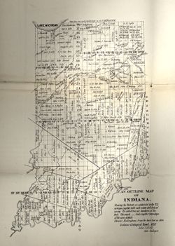
- Showing the Districts as subdivided by the U.S. Surveys, together with each name and date of survey. The dotted lines are boundaries of Districts. Ebenezer Buckingham, Jr. ran the base line in 1804. Detached from: Indiana Department of Geology and Natural History (Twelfth annual report) ... 1882. Indianapolis: Wm. B. Burford, 1883. Page 34.
- Call Number
- G4091.G46 1882 .C655
- Caption
- Imprint: [Indianapolis] :
- b[Indiana Dept. of Geology and Natural History],
- c[1882]
- Filename
- VAC3073-M-01145
- Subject
- Topical Subject: IGS Annual Reports
- Topical Subject: Land use surveys
- Geographic Subject: Indiana
- Title
- An outline map of Indiana
- Producer
- Collett, John, 1828-1899
- Physical Description
- Scale: Scale not given.
- Dimensions: 35 x 27 cm
- Item Identifiers
- Alternate ID: 390725IP
- Title Control Number: a18174045
- Persistent Identifier
- Campus
- IU Bloomington
- Date Created
- 1883
- Provenance
- 12th Annual Report (1882) / Indiana. Department of Geology and Natural History.
- Publisher
- Indiana. Department of Geology and Natural History
Relationships
Relationships
- In Collection:
Items
Show Item Images
| Thumbnail | Title | Date Uploaded | Visibility | Actions |
|---|---|---|---|---|
|
VAC3073-00297.jp2 | 2023-09-27 | Public |
|