
Image
Soil map of Switzerland County Public Deposited
- Genre
- Thematic maps
- Location
- Coordinates: W0851212 W0844704 N0385545 N0384115
- Related URL
- Abstract
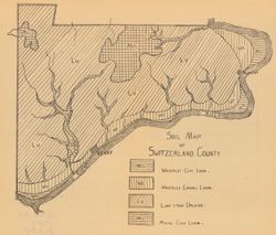
- Detached from: A soil survey of Decatur, Jennings, Jefferson, Ripley, Dearborn, Ohio, and Switzerland counties, Indiana / L.C. Ward. In Indiana Dept. of Geology and Natural Resources thirty-second annual report, 1907. Indianapolis: Wm. B. Burford, 1908. Page 234.
- Call Number
- G4093.S9J3 1907 .S6
- Caption
- Imprint: [Indianapolis] : [Indiana Department of Geology and Natural Resources], [1908]
- Filename
- VAC3073-M-00370
- Subject
- Topical Subject: Loam soils
- Geographic Subject: Switzerland County (Ind.)
- Topical Subject: IGS Annual Reports
- Title
- Soil map of Switzerland County
- Producer
- Ward, L. C. (Louis Clinton), 1878-1931
- Physical Description
- Scale: Scale not given.
- Dimensions: on sheet 21 x 24 cm
- Item Identifiers
- Title Control Number: a18349086
- Alternate ID: 390726IP
- Persistent Identifier
- Campus
- IU Bloomington
- Date Created
- 1908
- Provenance
- 32nd Annual Report (1907) / Indiana. Department of Geology and Natural Resources.
- Publisher
- Indiana. Department of Geology and Natural Resources
Relationships
Relationships
- In Collection:
Items
Show Item Images
| Thumbnail | Title | Date Uploaded | Visibility | Actions |
|---|---|---|---|---|
|
VAC3073-00254.jp2 | 2023-09-25 | Public |
|