
Image
Geological map of the lower Carboniferous area of Southern Indiana (Salem sheet) Public Deposited
- Genre
- Geological cross-sections
- Geological maps
- Location
- Coordinates: W0864100 W0853730 N0384700 N0382345
- Related URL
- Abstract
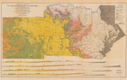
- Includes 4 East-West cross-sections through the center of townships 1, 2 and 3 North and 1 South. Vertical scale 1:9,600. Detached from: The geology of the lower Carboniferous area of Southern Indiana / by George Hall Ashley , assisted by Edward M. Kindle. In Indiana Department of Geology and Natural Resources twenty-seventh annual report ... 1902. Indianapolis : Wm. B. Burford, 1903. Page 52.
- Call Number
- G4091.C5 1902 .A82
- Caption
- Imprint: [Indianapolis] : Department of Geology and Natural Resources of Indiana, [1903]
- Imprint: Indianapolis, Ind. : Wm. B. Burford, [1903]
- Filename
- VAC3073-M-00912
- Subject
- Topical Subject: Coal mines and mining
- Geographic Subject: Indiana
- Topical Subject: Geology
- Topical Subject: Geology, Stratigraphic
- Topical Subject: Mines and mineral resources
- Title
- Geological map of the lower Carboniferous area of Southern Indiana (Salem sheet)
- Producer
- Kindle, E. M. (Edward Martin), 1869-1940
- Ashley, Geo. H. (George Hall), 1866-1951
- Blatchley, W. S. (Willis Stanley), 1859-1940
- Physical Description
- Dimensions: 46 x 74 cm, on sheet 50 x 78 cm
- Scale: Approximately 1:126,720. 2 miles = 1 in. Vertical scale approximately 1:9,600. 800 feet = 1 in.
- Item Identifiers
- Title Control Number: a16076838
- Alternate ID: 390726IP
- Persistent Identifier
- Campus
- IU Bloomington
- Date Created
- 1903
- Provenance
- 27th Annual Report (1902) / Indiana. Department of Geology and Natural Resources.
- Publisher
- Indiana. Department of Geology and Natural Resources
Relationships
Relationships
- In Collection:
Items
Show Item Images
| Thumbnail | Title | Date Uploaded | Visibility | Actions |
|---|---|---|---|---|
|
VAC3073-00035.jp2 | 2023-09-27 | Public |
|