
Image
Map of Barbee Lakes, Kosciusko County, Ind. Public Deposited
- Genre
- Maps
- Location
- Coordinates: W0854443 W0854115 N0411820 N0411636
- Related URL
- Abstract
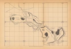
- Shows Barbee chain of lakes and local clubs and parks. Names of lakes as shown on map: Irish, Mabie (Sawmill), Plew (Sechrist), Kuhn (Little Barbee), Hammon (Big Barbee), and Dan Kuhn (Kuhn). Detached from: The lakes of northern Indiana and their associated marl deposits / W. S. Blatchley and Geo. H. Ashley. In Indiana Department of Geology and Natural Resources twenty-fifth annual report ... 1900. Indianapolis : Wm. B. Burford, 1901. Page 198.
- Call Number
- G4092.B3 1900 .M3
- Caption
- Imprint: [Indianapolis] : [Dept. of Geology and Natural Resources], [1901]
- Filename
- VAC3073-M-00295
- Subject
- Geographic Subject: Irish Lake (Ind.)
- Geographic Subject: Kosciusko County (Ind.)
- Geographic Subject: Big Barbee Lake (Ind.)
- Topical Subject: IGS Annual Reports
- Topical Subject: Lakes
- Geographic Subject: Sawmill Lake (Kosciusko County, Ind.)
- Geographic Subject: Sechrist Lake (Ind.)
- Geographic Subject: Kuhn Lake (Ind.)
- Geographic Subject: Little Barbee Lake (Ind.)
- Title
- Map of Barbee Lakes, Kosciusko County, Ind.
- Physical Description
- Dimensions: 22 x 32 cm
- Item Identifiers
- Title Control Number: a18189963
- Alternate ID: 390726IP
- Persistent Identifier
- Campus
- IU Bloomington
- Date Created
- 1901
- Provenance
- 25th Annual Report (1900) / Indiana. Department of Geology and Natural Resources.
- Publisher
- Indiana. Department of Geology and Natural Resources
Relationships
Relationships
- In Collection:
Items
Show Item Images
| Thumbnail | Title | Date Uploaded | Visibility | Actions |
|---|---|---|---|---|
|
VAC3073-00010.jp2 | 2023-09-25 | Public |
|