
Image
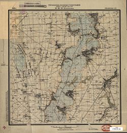
М-36-76-Б Жорноклевы Public Deposited
- Original Publication Date
1929
- Genre
- Military Maps
- Topographic Maps
- Location
- Coordinates: 49.833, 31.75, 50, 32
- Related URL
- Abstract
- Modern area represented: Жорнокльови (Zhornokl'ovy), Cherkasy oblast, Ukraine
- Call Number
- G7000 s50 .S68 sheet M-36-76-B
- Caption
- Captured map
- Рассекречено
- Не подлежит оглашению (crossed out)
- City
- Жорноклевы (Zhornoklevy)
- Copyright Owner
- No Copyright - United States
- Country
- СССР (USSR)
- Filename
- VAC9619-000991
- Subject
- Geographic Subject: Zhornokl'ovy
- Topical Subject: Maps
- Topical Subject: Soviet Union
- State/Region
- Украинская ССР (Ukrainian Soviet Socialist Republic)
- Title
- М-36-76-Б Жорноклевы
- Physical Description
- Scale: 1:50,000
- Language
- Russian
- Persistent Identifier
- Campus
- IU Bloomington
- Date Created
- 1932
- Provenance
- DMA Topographic Center, Army Map Service Library, OMAHA, Library of Congress Geography & Map Division
- Publisher
- Управление военных топографов
Relationships
Relationships
- In Collection:
Items
Show Item Images
| Thumbnail | Title | Date Uploaded | Visibility | Actions |
|---|---|---|---|---|
|
VAC9619-000991.jp2 | 2024-02-20 | Public |
|
|
VAC9619-U-001803.jp2 | 2024-02-20 | Public |
|