
Image
1929 Road Map Indiana Public Deposited
- Genre
- Road maps
- Location
- Coordinates: W0880700 W0844500 N0414500 N0375200
- Related URL
- Abstract
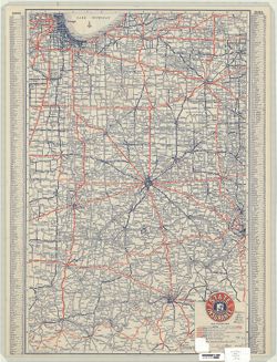
- Issued by the State Automobile Insurance Association. Includes place name index on recto. Advertisements and "Section of transcontinental highway map" showing the United States south of a line from Bangor, Maine to Wahpeton, North Dakota and east of a line from Limon, Colorado to Sanderson, Texas on verso.
- Call Number
- G4091.P2 1929 .G46
- Caption
- Imprint: Indianapolis : Cram, 1929.
- Filename
- VAC3073-M-00794
- Subject
- Geographic Subject: Indiana
- Topical Subject: Roads
- Title
- 1929 Road Map Indiana
- Producer
- George F. Cram Company
- Physical Description
- Scale: 1:860,000
- Dimensions: 58 x 38 cm
- Item Identifiers
- Title Control Number: a5051245
- Persistent Identifier
- Campus
- IU Bloomington
- Date Created
- 1929
- Publisher
- George F. Cram Company
Relationships
Relationships
- In Collection:
Items
Show Item Images
| Thumbnail | Title | Date Uploaded | Visibility | Actions |
|---|---|---|---|---|
|
VAC3073-M-00794.jp2 | 2023-09-27 | Public |
|

|
VAC3073-00504.jp2 | 2023-09-27 | Public |
|