
Image
Indiana Clay City quadrangle [1936 reprint] Public Deposited
- Genre
- Quadrangle maps
- 15 minute topographic maps
- Topographic maps
- Location
- Coordinates: W0871500 W0870000 N0393000 N0391500
- Related URL
- Abstract
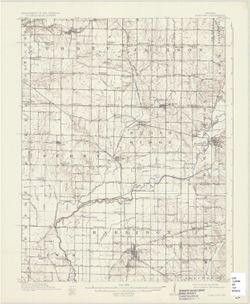
- Engraved July 1910 by U.S.G.S. , R. B. Marshall, chief geographer , W. H. Herron, geographer in charge , topography by C. L. Sadler , [and three others]. Relief shown by contours and spot heights. Includes map showing areas surveyed by Sadler and L. P. Jerrard. Contour interval 20 feet. Surveyed in 1908. Reprinted 1936.
- Call Number
- G4090 s62 .G4 Clay City 1910 rep1936
- Caption
- Imprint: [Washington, D.C.] : U.S. Geological Survey, 1936
- Filename
- VAC3073-M-01323
- Subject
- Geographic Subject: Vigo County (Ind.)
- Geographic Subject: Putnam County (Ind.)
- Geographic Subject: Clay County (Ind.)
- Geographic Subject: Owen County (Ind.)
- Title
- Indiana Clay City quadrangle [1936 reprint]
- Producer
- Sadler, C. L.
- Marshall, R. B. (Robert Bradford), 1867-1949
- Geological Survey (U.S.)
- Herron, W. H. (William Harrison), 1865-
- Physical Description
- Scale: 1:62,500
- Dimensions: 45 x 42 cm or smaller
- Item Identifiers
- Title Control Number: a18406394
- Persistent Identifier
- Campus
- IU Bloomington
- Date Created
- 1936
- Provenance
- Part of Geological Survey (U.S.). Indiana 1:62,500.
- Publisher
- Geological Survey (U.S.)
Relationships
Relationships
- In Collection:
Items
Show Item Images
| Thumbnail | Title | Date Uploaded | Visibility | Actions |
|---|---|---|---|---|
|
VAC3073-M-01323.jp2 | 2023-09-28 | Public |
|