
Image
Illinois-Indiana Momence quadrangle Public Deposited
- Genre
- Quadrangle maps
- Topographic maps
- 15 minute topographic maps
- Location
- Coordinates: W0874500 W0873000 N0411500 N0410000
- Related URL
- Abstract
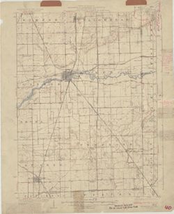
- Filing title: Momence, Ill.-Ind. Polyconic projection. Relief shown by contours and spot heights. Shows Kankakee County, Illinois, as well as small portions of Iroquois, Illinois, and Newton and Lake counties in Indiana. Surveyed in 1922. Contour interval 10 feet. Topography by J. H. Jennings, H. E. Simmons, J. F. McCook, R. F. Wilcoxon, W. S. Beames, E. V. Perkinson, and G. G. Martin. At head of map: "State of Illinois, Department of Registration and Education, A.M. Shelton, Director. Geological Survey Division, Frank W. De Wolf, Chief."
- Call Number
- G4090 s62 .G4 Momence 1924
- Caption
- Imprint: [Urbana, Ill.] : Geological Survey Division, 1924
- Imprint: [Washington, D.C.] : U.S. Geological Survey
- Filename
- VAC3073-M-01350
- Subject
- Geographic Subject: Lake County (Ind.)
- Geographic Subject: Newton County (Ind.)
- Geographic Subject: Kanakee County (Ill.)
- Geographic Subject: Iroquois County (Ill.)
- Title
- Illinois-Indiana Momence quadrangle
- Producer
- Geological Survey (U.S.)
- U.S. Lake Survey
- Illinois State Geological Survey
- Jennings, J. H. (James H.), 1864-1927
- Illinois. Department of Registration and Education
- Physical Description
- Dimensions: 45 x 42 cm or smaller
- Scale: 1:62,500
- Item Identifiers
- Title Control Number: a18408408
- Persistent Identifier
- Campus
- IU Bloomington
- Date Created
- 1924
- Provenance
- Part of Geological Survey (U.S.). Indiana 1:62,500.
- Publisher
- Geological Survey (U.S.)
Relationships
Relationships
- In Collection:
Items
Show Item Images
| Thumbnail | Title | Date Uploaded | Visibility | Actions |
|---|---|---|---|---|
|
VAC3073-M-01350.jp2 | 2023-09-28 | Public |
|