
Image
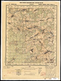
O-36-130-A Public Deposited
- Original Publication Date
1938
- Genre
- Military Maps
- Topographic Maps
- Location
- Coordinates: 56.5, 34.5, 56.667, 34.75
- Related URL
- Abstract
- Modern area represented: Kruttsy, Tver oblast, Russia
- Call Number
- G7000 s50 .S68 sheet O-36-130-A
- City
- Крутцы (Kruttsy)
- Copyright Owner
- No Copyright - United States
- Country
- СССР (USSR)
- Filename
- VAC9619-003475
- Subject
- Topical Subject: Soviet Union
- Geographic Subject: Kruttsy
- Topical Subject: Maps
- State/Region
- Старицкий район (Staritsky district)
- Калининская область (Kalinin oblast)
- Луковниковский район (Lukovnikovsky district)
- Высоковский район (Vysokovsky district)
- Ржевский район (Rzhevsky district)
- Title
- O-36-130-A
- Physical Description
- Scale: 1:50,000
- Language
- Russian
- Persistent Identifier
- Campus
- IU Bloomington
- Date Created
- 1941
- Provenance
- DMA Topographic Center, Army Map Service Library, OMAHA, Library of Congress Geography & Map Division
- Publisher
- Главное управление государственной съемки и картографии НКВД СССР
Relationships
Relationships
- In Collection:
Items
Show Item Images
| Thumbnail | Title | Date Uploaded | Visibility | Actions |
|---|---|---|---|---|

|
VAC9619-003475.jp2 | 2024-02-02 | Public |
|
|
VAC9619-U-003811.jp2 | 2024-02-02 | Public |
|