
Image
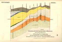
Geological section from South Bend to Winchester, illustrating table no. IV Public Deposited
- Genre
- Geological cross-sections
- Location
- Coordinates: W0862100 W0844815 N0414545 N0400900
- Related URL
- Abstract
- Geological cross section showing stratigraphy of mineral resources, including various limestone and shale layers. Relative relief in relation to sea level shown by profile. See "Map showing lines of geological sections and the relation of Trenton rock to sea level" for location of profile line. Detached from: Indiana's structural features as revealed by the drill / E. P. Cubberley. In Indiana Department of Geology and Natural Resources eighteenth annual report ... 1893. Indianapolis: Wm. B. Burford, 1894. Page 229.
- Call Number
- G4091.C57 1893 .C83, no. 4
- Caption
- Imprint: [Indianapolis] : [Indiana, Dept. of Geology and Natural Resources], [1894]
- Imprint: Indpls : lithographed by William B. Burford, [1894]
- Filename
- VAC3073-M-01568
- Subject
- Topical Subject: IGS Annual Reports
- Topical Subject: Mines and mineral resources
- Geographic Subject: Indiana
- Topical Subject: Geology, Stratigraphic
- Title
- Geological section from South Bend to Winchester, illustrating table no. IV
- Producer
- Cubberley, Ellwood P., 1868-1941
- Physical Description
- Scale: Approximately 1:1,900,800. 30 miles to the inch. Vertical scale approximately 1:6,000. 500 feet to the inch
- Dimensions: 15 x 23 cm
- Item Identifiers
- Alternate ID: 390726IP
- Title Control Number: a18224917
- Persistent Identifier
- Campus
- IU Bloomington
- Date Created
- 1894
- Provenance
- 18th Annual Report (1893) / Indiana. Department of Geology and Natural Resources.
- Publisher
- Indiana. Department of Geology and Natural Resources
Relationships
Relationships
- In Collection:
Items
Show Item Images
| Thumbnail | Title | Date Uploaded | Visibility | Actions |
|---|---|---|---|---|
|
VAC3073-M-01568.jp2 | 2023-09-28 | Public |
|