
Image
Map of Warren County, Indiana Public Deposited
- Genre
- Geological maps
- Location
- Coordinates: W0873200 W0870600 N0402800 N0400700
- Related URL
- Abstract
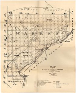
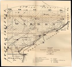
- Relief shown by hachures. Shows cities and towns, operating and proposed railroads, prairies, test bores, deposits of iron ore and mill stone grit, mills, quarries, working coal mines, coal seams, coal shafts, coal outcroppings, and "bounds of sub-carboniferous formation." Shows principal natural features and includes descriptions of landscape features and land cover. Also shows "Gen. Harrison's line of march to the battle of Tippecanoe, 1811." Detached from: Geology of Warren County / By John Collett. In Fifth annual report of the Geological Survey of Indiana, made during the year 1873. Indianapolis: Sentinel Company, 1874.
- Call Number
- G4093.W3C5 1873 .C6
- Caption
- Imprint: [Indianapolis] : [Sentinel Company, printers], [1874]
- Filename
- VAC3073-M-01171
- Subject
- Topical Subject: Mines and mineral resources
- Topical Subject: Geology
- Topical Subject: IGS Annual Reports
- Geographic Subject: Warren County (Ind.)
- Topical Subject: Coal mines and mining
- Title
- Map of Warren County, Indiana
- Producer
- Collett, John, 1828-1899
- Physical Description
- Scale: Approximately 1:120,000
- Dimensions: 44 x 36 cm
- Item Identifiers
- Title Control Number: a15734000
- Alternate ID: 390723IP
- Persistent Identifier
- Campus
- IU Bloomington
- Date Created
- 1873
- Provenance
- 5th Annual Report (1873) / Indiana. Geological Survey.
- Publisher
- Indiana. Geological Survey
Relationships
Relationships
- In Collection:
Items
Show Item Images
| Thumbnail | Title | Date Uploaded | Visibility | Actions |
|---|---|---|---|---|
|
VAC3073-M-01171.jp2 | 2023-09-27 | Public |
|
|
VAC3073-00946.jp2 | 2023-09-27 | Public |
|