
Image
Map of the Indiana natural gas field Public Deposited
- Genre
- Geological maps
- Location
- Coordinates: W0864100 W0844800 N0410000 N0390500
- Related URL
- Abstract
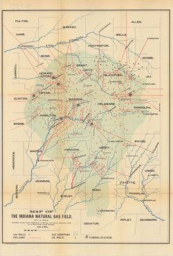
- Shows gas wells, pipelines, pumping stations, and oil wells in east-central Indiana. Detached from: Report of the State Natural Gas Supervisor / J.C. Leach. In Indiana Dept. of Geology and Natural Resources twentieth annual report. Indianapolis: Wm. B. Burford, 1896. Page 386.
- Call Number
- G4091.H8 1895 .L4
- Caption
- Imprint: Indianapolis, Ind. : Wm. B. Burford, Lith., [1896]
- Filename
- VAC3073-M-01064
- Subject
- Topical Subject: IGS Annual Reports
- Topical Subject: Gas fields
- Topical Subject: Gas wells
- Geographic Subject: Indiana
- Topical Subject: Oil wells
- Topical Subject: Natural gas pipelines
- Title
- Map of the Indiana natural gas field
- Producer
- Leach, J. C.
- Physical Description
- Dimensions: 56 x 39 cm
- Scale: Approximately 1:434,000
- Item Identifiers
- Title Control Number: a18225037
- Alternate ID: 390726IP
- Persistent Identifier
- Campus
- IU Bloomington
- Date Created
- 1896
- Provenance
- 20th Annual Report (1895) / Indiana. Department of Geology and Natural Resources.
- Publisher
- Indiana. Department of Geology and Natural Resources
Relationships
Relationships
- In Collection:
Items
Show Item Images
| Thumbnail | Title | Date Uploaded | Visibility | Actions |
|---|---|---|---|---|
|
VAC3073-00185.jp2 | 2023-09-27 | Public |
|