
Image
Soil map of Wayne County Public Deposited
- Genre
- Thematic maps
- Location
- Coordinates: W0851316 W0844838 N0400022 N0394253
- Related URL
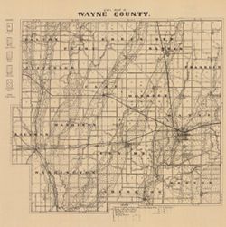
- Abstract
- Shows roads and railroads. Includes notes on general topography. Detached from: A soil survey of Randolph, Wayne, Henry, Rush, Fayette, Union and Franklin counties / Arthur E. Taylor. In Indiana Department of Geology and Natural Resources thirty-fourth annual report ... 1909. Indianapolis : Wm. B. Burford, 1910. Page 54.
- Call Number
- G4093.W6J3 1909 .I53
- Caption
- Imprint: [Indianapolis] : [Indiana Department of Geology and Natural Resources], [1910]
- Filename
- VAC3073-M-00002
- Subject
- Topical Subject: Soils
- Geographic Subject: Wayne County (Ind.)
- Title
- Soil map of Wayne County
- Producer
- Indiana. Department of Geology and Natural Resources
- Physical Description
- Scale: Approximately 1:126,720
- Dimensions: 26 x 29 cm
- Item Identifiers
- Title Control Number: a16124401
- Alternate ID: 390726IP
- Persistent Identifier
- Campus
- IU Bloomington
- Date Created
- 1910
- Provenance
- 34th Annual Report (1909) / Indiana. Department of Geology and Natural Resources.
- Publisher
- Indiana. Department of Geology and Natural Resources
Relationships
Relationships
- In Collection:
Items
Show Item Images
| Thumbnail | Title | Date Uploaded | Visibility | Actions |
|---|---|---|---|---|
|
VAC3073-00285.jp2 | 2023-09-21 | Public |
|