
Image
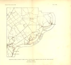
Geological map of eastern Clark County, outlining the eastern border of the upper Silurian Public Deposited
- Genre
- Geological maps
- Location
- Coordinates: W0854136 W0852427 N0383546 N0382455
- Related URL
- Abstract
- "Plate XIV." Detached from: A report on the geology of the middle and upper Silurian rocks of Clark, Jefferson, Ripley, Jennings and southern Decatur counties, Ind. / August F. Foerste. In Indiana Dept. of Geology and Natural Resources twenty-first annual report, 1896. Indianapolis: Wm. B. Burford, 1897. Page 232.
- Call Number
- G4093.C4C57 1896 .F6
- Caption
- Imprint: [Indianapolis] : [Indiana Dept. of Geology and Natural Resources], [1897]
- Filename
- VAC3073-M-01142
- Subject
- Topical Subject: Geology, Stratigraphic--Silurian
- Topical Subject: IGS Annual Reports
- Geographic Subject: Clark County (Ind.)
- Topical Subject: Geology
- Title
- Geological map of eastern Clark County, outlining the eastern border of the upper Silurian
- Producer
- Foerste, Aug. F. (Aug. Frederic), 1862-1936
- Physical Description
- Dimensions: 23 x 24 cm
- Scale: Approximately 1:126,720. 2 miles = 1 inch
- Item Identifiers
- Title Control Number: a17036420
- Alternate ID: 390726IP
- Persistent Identifier
- Campus
- IU Bloomington
- Date Created
- 1897
- Provenance
- 21st Annual Report (1896) / Indiana. Department of Geology and Natural Resources.
- Publisher
- Indiana. Department of Geology and Natural Resources
Relationships
Relationships
- In Collection:
Items
Show Item Images
| Thumbnail | Title | Date Uploaded | Visibility | Actions |
|---|---|---|---|---|
|
VAC3073-M-01142.jp2 | 2023-09-27 | Public |
|