
Image
1949 state highway system of Indiana Public Deposited
- Genre
- Road maps
- Location
- Coordinates: W0880500 W0844700 N0414500 N0374600
- Related URL
- Abstract
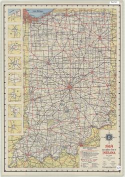
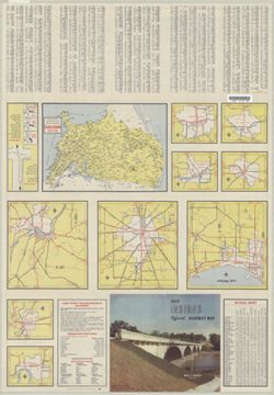
- Panel title: 1949 Indiana official highway map. Relief shown by spot heights. Includes 8 local route maps. Index, distance chart, distance map of the United States, state police directory, color illustrations, and 9 local route maps on verso.
- Call Number
- G1403 .S7 1949
- Caption
- Imprint: [Indianapolis] : State Highway Commission, [1949]
- Filename
- VAC3073-M-01236
- Subject
- Geographic Subject: Indiana
- Topical Subject: Roads
- Title
- 1949 state highway system of Indiana
- Producer
- Indiana. State Highway Commission (1919-1953)
- Physical Description
- Dimensions: 94 x 59 cm
- Scale: Approximately 1:633,600
- Item Identifiers
- Title Control Number: a18406077
- Persistent Identifier
- Campus
- IU Bloomington
- Date Created
- 1949
- Provenance
- Indiana state highway system
- Publisher
- Indiana. State Highway Commission (1919-1953)
Relationships
Relationships
- In Collection:
Items
Show Item Images
| Thumbnail | Title | Date Uploaded | Visibility | Actions |
|---|---|---|---|---|
|
VAC3073-M-01236.jp2 | 2023-09-28 | Public |
|
|
VAC3073-00590.jp2 | 2023-09-28 | Public |
|