
Image
Brownstown, Ind. [Advance printing] Public Deposited
- Genre
- Topographic maps
- 7.5 minute topographic maps
- Quadrangle maps
- Location
- Coordinates: W0860730 W0860000 N0385230 N0384500
- Related URL
- Abstract
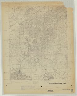
- EDC , 461 edge worked by L. R. Mannello , 461 [and] 441 edge joined by L. R. Mannello. "EDC, C. Dickey 1958-09-15. ... Scribed by R. Mills." Topographic quadrangle showing Jackson County, Indiana, and a small portion of Washington County, Indiana. Relief shown by contours and spot heights. Includes production notes and annotations on needed edits and changes. Stamped on recto: "This is an incomplete, unedited copy of an original map manuscript having an inherent accuracy appropriate for 1:24,000 scale publication. ... Before field completion." "Photography used: GS-VKOS 7-13 to 7-19, 4-119 to 4-125, 4-48 to 4-53, 4-8 to 4-13, 3-307 to 3-313 & 3-379."
- Call Number
- G4090 s24 .G4 Indiana 1958 ADV
- Caption
- Imprint: [Indiana] : EDC, 1958-09-15
- Filename
- VAC3073-M-01446
- Subject
- Geographic Subject: Jackson County (Ind.)
- Geographic Subject: Washington County (Ind.)
- Title
- Brownstown, Ind. [Advance printing]
- Producer
- EROS Data Center
- Mannello, L. R. (Leonard R.)
- Physical Description
- Dimensions: on sheet 69 x 56 cm
- Scale: 1:24,000
- Item Identifiers
- Title Control Number: a18422458
- Persistent Identifier
- Campus
- IU Bloomington
- Date Created
- 1958
- Publisher
- EROS Data Center
Relationships
Relationships
- In Collection:
Items
Show Item Images
| Thumbnail | Title | Date Uploaded | Visibility | Actions |
|---|---|---|---|---|
|
VAC3073-M-01446.jp2 | 2023-09-28 | Public |
|