
Image
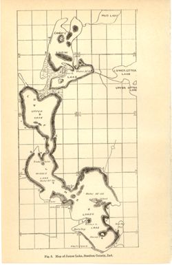
Map of James Lake, Steuben County, Ind. Public Deposited
- Genre
- Thematic maps
- Location
- Coordinates: W0850253 W0850033 N0414428 N0414050
- Related URL
- Abstract
- Depth shown by average depth range for each lake. Also shows information for Snow Lake and general locations of Mud Lake and Upper and Lower Otter Lakes. Detached from: The lakes of northern Indiana and their associated marl deposits / W. S. Blatchley and Geo. H. Ashley. In Indiana Department of Geology and Natural Resources twenty-fifth annual report ... 1900. Indianapolis : Wm. B. Burford, 1901. Page 76.
- Call Number
- G4092.J27 1900 .M37
- Caption
- Imprint: [Indianapolis] : [Wm. B. Burford], [1901]
- Imprint: [Indianapolis] : [Indiana, Department of Geology and Natural History], [1901]
- Filename
- VAC3073-M-01178
- Subject
- Geographic Subject: James, Lake (Steuben County, Ind. : Lake)
- Topical Subject: Lakes
- Topical Subject: IGS Annual Reports
- Geographic Subject: Steuben County (Ind.)
- Geographic Subject: Snow Lake (Ind.)
- Title
- Map of James Lake, Steuben County, Ind.
- Physical Description
- Dimensions: on sheet 23 x 15 cm
- Scale: Approximately 1:32,000
- Item Identifiers
- Alternate ID: 390726IP
- Title Control Number: a18190007
- Persistent Identifier
- Campus
- IU Bloomington
- Date Created
- 1901
- Provenance
- 25th Annual Report (1900) / Indiana. Department of Geology and Natural Resources.
- Publisher
- Indiana. Department of Geology and Natural Resources
Relationships
Relationships
- In Collection:
Items
Show Item Images
| Thumbnail | Title | Date Uploaded | Visibility | Actions |
|---|---|---|---|---|
|
VAC3073-M-01178.jp2 | 2023-09-27 | Public |
|