
Image
Soil map, Indiana, Decatur County sheet Public Deposited
- Genre
- Thematic maps
- Location
- Coordinates: W0854100 W0851800 N0392700 N0390800
- Related URL
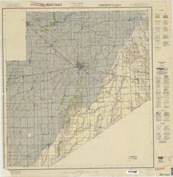
- Abstract
- Soils surveyed by Mark Baldwin and J.A. Slipher, U.S. Dept. of Agriculture and S. C. Jones, Purdue University Agricultural Experiment Station.
- Call Number
- G4093.D4J3 1919 .B35
- Caption
- Imprint: Washington, D.C.: Bureau of Soils. [1919?]
- Filename
- VAC3073-M-00363
- Subject
- Geographic Subject: Decatur County (Ind.)
- Topical Subject: Soils
- Topical Subject: Classification
- Title
- Soil map, Indiana, Decatur County sheet
- Physical Description
- Dimensions: 59 x 55 cm
- Scale: 1:63,360
- Item Identifiers
- Title Control Number: CAX0851BB
- Persistent Identifier
- Campus
- IU Bloomington
- Date Created
- 1919
- Provenance
- Soil Map, Indiana, Decatur County Sheet.
- Publisher
- United States. Bureau of Soils
Relationships
Relationships
- In Collection:
Items
Show Item Images
| Thumbnail | Title | Date Uploaded | Visibility | Actions |
|---|---|---|---|---|
|
VAC3073-M-00363.jp2 | 2023-09-25 | Public |
|