
Search Constraints
You searched for:
Publisher
Управление военных топографов РККА
Remove constraint Publisher: Управление военных топографов РККА
« Previous |
1 - 10 of 462
|
Next »
Search Results
-
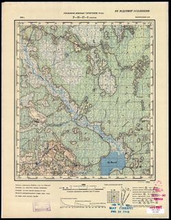
- Description:
- 1936
- Subject:
- Geographic Subject: Ubarok, Topical Subject: Soviet Union, and Topical Subject: Maps
- Publisher:
- Управление военных топографов РККА
- Language:
- Russian
- Date Created:
- 1937
- Identifier:
- VAC9619-000567
- Genre:
- Topographic Maps and Military Maps
- Geographic Location:
- Coordinates: 54.5, 28.25, 54.667, 28.5
- Related URL:
- Catalog URL: http://iucat.iu.edu/catalog/5020131 and Download GeoTIFF: https://drive.google.com/open?id=1yIx-TM28JTWHuBhMdWOWkQ0Os1GV8Y7K
- Abstract:
- Modern area represented: Ubarok, Minsk oblast, Belarus
- Call Number:
- G7000 s50 .S68 sheet N-35-57-B
- Caption:
- Не подлежит оглашению
- City:
- Уборок (Uborok)
- Copyright Holder:
- No Copyright - United States
- Country:
- СССР (USSR)
- State/Province:
- Белорусская ССР (Byelorussian Soviet Socialist Republic)
- Physical Description:
- Scale: 1:50,000
- Persistent URL:
- http://purl.dlib.indiana.edu/iudl/images/VAC9619/VAC9619-000567
- Provenance:
- M. I. Map Library, Justus Perthes Kartensammlung, G000-30
-
- Description:
- 1933
- Subject:
- Topical Subject: Maps, Topical Subject: Soviet Union, and Geographic Subject: Zembin
- Publisher:
- Управление военных топографов РККА
- Language:
- Russian
- Date Created:
- 1937
- Identifier:
- VAC9619-000568
- Genre:
- Military Maps and Topographic Maps
- Geographic Location:
- Coordinates: 54.333, 28, 54.5, 28.25
- Related URL:
- Download GeoTIFF: https://drive.google.com/open?id=1rwwVK0vXb4_ePYGis1SCFQTSj3dLIwd5 and Catalog URL: http://iucat.iu.edu/catalog/5020131
- Abstract:
- Modern area represented: Zembin, Minsk oblast, Belarus
- Call Number:
- G7000 s50 .S68 sheet N-35-57-C
- Caption:
- Не подлежит оглашению
- City:
- Зембин (Zembin)
- Copyright Holder:
- No Copyright - United States
- Country:
- СССР (USSR)
- State/Province:
- Белорусская ССР (Byelorussian Soviet Socialist Republic)
- Physical Description:
- Scale: 1:50,000
- Persistent URL:
- http://purl.dlib.indiana.edu/iudl/images/VAC9619/VAC9619-000568
- Provenance:
- Army Map Service Library, OMAHA, Library of Congress Geography & Map Division
-
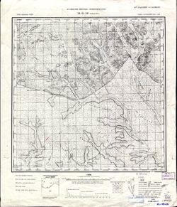
- Description:
- 1931
- Subject:
- Geographic Subject: Romny, Topical Subject: Maps, and Topical Subject: Soviet Union
- Publisher:
- Управление военных топографов РККА
- Language:
- Russian
- Date Created:
- 1937
- Identifier:
- VAC9619-000955
- Genre:
- Military Maps and Topographic Maps
- Geographic Location:
- Coordinates: 50.666667, 33.5, 50.833333, 33.75
- Related URL:
- Download GeoTIFF: https://drive.google.com/open?id=1rnfkKiB1ABVQkI-6sNsQc61EBpY-hEs5 and Catalog URL: http://iucat.iu.edu/catalog/5020131
- Abstract:
- Modern area represented: Romny, Sumy oblast, Ukraine
- Call Number:
- G7000 s50 .S68 sheet M-36-44-C
- Caption:
- Не подлежит оглашению
- City:
- Засулье (Zasulye)
- Copyright Holder:
- No Copyright - United States
- Country:
- СССР (USSR)
- State/Province:
- Украинская ССР (Ukrainian Soviet Socialist Republic) and Черниговская область (Chernihiv oblast)
- Physical Description:
- Scale: 1:50,000
- Persistent URL:
- http://purl.dlib.indiana.edu/iudl/images/VAC9619/VAC9619-000955
- Provenance:
- DMA Topographic Center, Army Map Service Library, Library of Congress Geography & Map Division
-
- Description:
- 1932
- Subject:
- Topical Subject: Soviet Union, Geographic Subject: Горностайпіль (Hornostaypil'), and Topical Subject: Maps
- Publisher:
- Управление военных топографов РККА
- Language:
- Russian
- Date Created:
- 1937
- Identifier:
- VAC9619-000929
- Genre:
- Military Maps and Topographic Maps
- Geographic Location:
- Coordinates: 51, 30.25, 51.1667, 30.5
- Related URL:
- Catalog URL: http://iucat.iu.edu/catalog/5020131 and Download GeoTIFF: https://drive.google.com/open?id=1p32O1uBhB5Rhso2iI4XobJZ0Td8vNnJ1
- Abstract:
- Modern area represented: Горностайпіль (Hornostaypil'), Kyiv oblast, Ukraine
- Call Number:
- G7000 s50 .S68 sheet M-36-25-D
- Caption:
- Не подлежит оглашению
- City:
- Горностайполь (Gornostaypol')
- Copyright Holder:
- No Copyright - United States
- Country:
- СССР (USSR)
- State/Province:
- Киевская область (Kyiv oblast) and Украинская ССР (Ukrainian Soviet Socialist Republic)
- Physical Description:
- Scale: 1:50,000
- Persistent URL:
- http://purl.dlib.indiana.edu/iudl/images/VAC9619/VAC9619-000929
- Provenance:
- DMA Topographic Center, Army Map Service Library, Library of Congress Geography & Map Division
-
- Description:
- 1909
- Subject:
- Geographic Subject: Stavropol’ Krai, Topical Subject: Maps, Topical Subject: Soviet Union, and Geographic Subject: Pyatigorsk
- Publisher:
- Управление военных топографов РККА
- Language:
- Russian
- Date Created:
- 1936
- Identifier:
- VAC9619-002242
- Genre:
- Military Maps and Topographic Maps
- Geographic Location:
- Coordinates: 44, 43, 44.3333, 43.5
- Related URL:
- Download GeoTIFF: https://drive.google.com/file/d/1b87g1ffiH5tUIIxMUlRAMC1SpRo9sRtq/view?usp=sharing and Catalog URL: https://iucat.iu.edu/catalog/5020129
- Abstract:
- Modern area represented: Пятигорск (Pyatigorsk), Stavropol’ Krai, Russia
- Call Number:
- G7000 s100 .S7 sheet L-38-135
- Caption:
- Для cлужебного пользования
- City:
- Пятигорск (Pyatigorsk)
- Copyright Holder:
- No Copyright - United States
- Country:
- СССР (USSR)
- State/Province:
- Орджоникидзевский край (Ordzhonikidze kray) and РСФСР (RSFSR)
- Physical Description:
- Scale: 1:100,000
- Persistent URL:
- http://purl.dlib.indiana.edu/iudl/images/VAC9619/VAC9619-002242
- Provenance:
- DMA Topographic Center, Army Map Service Library
-
- Description:
- 1913
- Subject:
- Geographic Subject: Baldzhikan, Topical Subject: Maps, and Topical Subject: Soviet Union
- Publisher:
- Управление военных топографов РККА
- Language:
- Russian
- Date Created:
- 1936
- Identifier:
- VAC9619-003551
- Genre:
- Topographic Maps and Military Maps
- Geographic Location:
- Coordinates: 49, 110, 49.333, 110.5
- Related URL:
- Download GeoTIFF: https://drive.google.com/file/d/1EDdpb1Qpq4XTzjSQ3wYTtMmQ_tYdDFSv/view?usp=sharing and Catalog URL: https://iucat.iu.edu/catalog/5020129
- Abstract:
- Modern area represented: Baldzhikan, Transbaikal territory, Russia
- Call Number:
- G7000 s100 .S7 sheet M-49-101
- Caption:
- Не подлежит оглашению
- City:
- Бальджикан (Baldzhikan)
- Copyright Holder:
- No Copyright - United States
- Country:
- СССР (USSR)
- State/Province:
- РСФСР (RSFSR) and Читинская область (Chita oblast)
- Physical Description:
- Scale: 1:100,000
- Persistent URL:
- http://purl.dlib.indiana.edu/iudl/images/VAC9619/VAC9619-003551
- Provenance:
- Library of Congress G & M Division, University of Kansas Map Library
-
- Description:
- 1924
- Subject:
- Topical Subject: Maps, Geographic Subject: Omut, and Topical Subject: Soviet Union
- Publisher:
- Управление военных топографов РККА
- Language:
- Russian
- Date Created:
- 1936
- Identifier:
- VAC9619-000020
- Genre:
- Military Maps and Topographic Maps
- Geographic Location:
- Coordinates: 59, 27.75, 59.167, 28
- Related URL:
- Download GeoTIFF: https://drive.google.com/open?id=1x6coF_bFqa5VyWZ_JSrewAbtpu4RSn_0 and Catalog URL: http://iucat.iu.edu/catalog/5020131
- Abstract:
- Modern area represented: Omut, Russia
- Call Number:
- G7000 s50 .S68 sheet O-35-32-D
- Caption:
- Секретно,Captured map
- City:
- Омути (Omut)
- Copyright Holder:
- No Copyright - United States
- Country:
- СССР (USSR) and Эстония (Estonia)
- State/Province:
- РСФСР (RSFSR) and Ленинградская область (Leningrad oblast)
- Physical Description:
- Scale: 1:50,000
- Persistent URL:
- http://purl.dlib.indiana.edu/iudl/images/VAC9619/VAC9619-000020
- Provenance:
- Army Map Service Library, OMAHA, Library of Congress Geography & Map Division
-
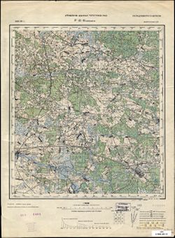
- Description:
- 1933
- Subject:
- Topical Subject: Soviet Union, Geographic Subject: Smilavichy, and Topical Subject: Maps
- Publisher:
- Управление военных топографов РККА
- Language:
- Russian
- Date Created:
- 1936
- Identifier:
- VAC9619-004081
- Genre:
- Military Maps and Topographic Maps
- Geographic Location:
- Coordinates: 53.667, 28, 54, 28.5
- Related URL:
- Download GeoTIFF: https://drive.google.com/file/d/1H8FweVO9LnHfFCQ6pbRGNdMLVVsrPnp4/view?usp=sharing and Catalog URL: https://iucat.iu.edu/catalog/5020129
- Abstract:
- Modern area represented: Smilavichy, Belarus
- Call Number:
- G7000 s100 .S7 sheet N-35-81
- Caption:
- Не подлежит оглашению
- City:
- Смиловичи (Smilavichy)
- Copyright Holder:
- No Copyright - United States
- Country:
- СССР (USSR)
- State/Province:
- Белорусская ССР (Byelorussian Soviet Socialist Republic)
- Physical Description:
- Scale: 1:100,000
- Persistent URL:
- http://purl.dlib.indiana.edu/iudl/images/VAC9619/VAC9619-004081
- Provenance:
- Library of Congress G & M Division
-
- Description:
- 1904
- Subject:
- Topical Subject: Soviet Union, Topical Subject: Maps, and Geographic Subject: Kiyevichi
- Publisher:
- Управление военных топографов РККА
- Language:
- Russian
- Date Created:
- 1936
- Identifier:
- VAC9619-000708
- Genre:
- Military Maps and Topographic Maps
- Geographic Location:
- Coordinates: 52.833, 26.75, 53, 27
- Related URL:
- Catalog URL: http://iucat.iu.edu/catalog/5020131 and Download GeoTIFF: https://drive.google.com/open?id=1tTKI474LW2kDomqmBh1_w15EeaX7m8st
- Abstract:
- Modern area represented: Kiyevichi, Minsk oblast, Belarus
- Call Number:
- GM G7000 s50 .S68 N-35-114-Б
- Caption:
- Не подлежит оглашению
- City:
- Киевичи (Kiyevichi)
- Copyright Holder:
- No Copyright - United States
- Country:
- СССР (USSR) and Польша (Poland)
- State/Province:
- Белорусская ССР (Byelorussian Soviet Socialist Republic)
- Physical Description:
- Scale: 1:50,000
- Persistent URL:
- http://purl.dlib.indiana.edu/iudl/images/VAC9619/VAC9619-000708
- Provenance:
- Army Map Service Library, Auswärtiges Amt. Geographischer Dienst, OMAHA, Library of Congress Geography & Map Division
-
- Description:
- 1917
- Subject:
- Topical Subject: Soviet Union, Topical Subject: Maps, and Geographic Subject: Moroch
- Publisher:
- Управление военных топографов РККА
- Language:
- Russian
- Date Created:
- 1936
- Identifier:
- VAC9619-004130
- Genre:
- Topographic Maps and Military Maps
- Geographic Location:
- Coordinates: 52.333, 27.5, 52.667, 28
- Related URL:
- Catalog URL: https://iucat.iu.edu/catalog/5020129 and Download GeoTIFF: https://drive.google.com/file/d/1HUuzBKcEpGGkMff5L63dHETUlsQCusTP/view?usp=sharing
- Abstract:
- Modern area represented: Moroch, Minsk oblast, Belarus
- Call Number:
- G7000 s100 .S7 sheet N-35-128
- Caption:
- Не подлежит оглашению
- City:
- Морочь (Moroch)
- Copyright Holder:
- No Copyright - United States
- Country:
- Польша (Poland) and СССР (USSR)
- State/Province:
- Белорусская ССР (Byelorussian Soviet Socialist Republic)
- Physical Description:
- Scale: 1:100,000
- Persistent URL:
- http://purl.dlib.indiana.edu/iudl/images/VAC9619/VAC9619-004130
- Provenance:
- DMA Topographic Center, Army Map Service Library
