
Search Constraints
You searched for:
Country
Германия (Germany)
Remove constraint Country: Германия (Germany)
Date Created
1941
Remove constraint Date Created: 1941
« Previous |
1 - 20 of 80
|
Next »
Search Results
-
- Subject:
- Geographic Subject: Jelonki, Topical Subject: Soviet Union, and Topical Subject: Maps
- Publisher:
- Генеральный штаб Красной Армии
- Language:
- Russian
- Date Created:
- 1941
- Identifier:
- VAC9619-003794
- Genre:
- Topographic Maps and Military Maps
- Geographic Location:
- Coordinates: 54.0, 19.5, 54.083333, 19.625
- Related URL:
- Download GeoTIFF: https://drive.google.com/file/d/1lTM0VLznEr2rkz5aWONT4uGWUShBFUf3/view?usp=sharing and Catalog URL: https://iucat.iu.edu/catalog/14701157
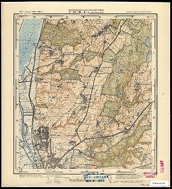
- Abstract:
- Modern area represented: Jelonki, Poland
- Call Number:
- G7063.K2 s25 .S6 sheet N-34-64-C-c
- City:
- Гиршфельд (Hirschfeld)
- Copyright Holder:
- No Copyright - United States
- Country:
- Восточная Пруссия (East Prussia) and Германия (Germany)
- Physical Description:
- Scale: 1:25,000
- Persistent URL:
- http://purl.dlib.indiana.edu/iudl/images/VAC9619/VAC9619-003794
- Provenance:
- M. I. Map Library, G000-30, GS, RA
-
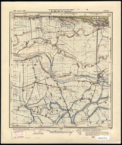
- Subject:
- Geographic Subject: Malbork, Topical Subject: Maps, and Topical Subject: Soviet Union
- Publisher:
- Генеральный штаб Красной Армии
- Language:
- Russian
- Date Created:
- 1941
- Identifier:
- VAC9619-003786
- Genre:
- Military Maps and Topographic Maps
- Geographic Location:
- Coordinates: 54, 19, 54.083, 19.125
- Related URL:
- Download GeoTIFF: https://drive.google.com/file/d/1Xzrws6cS9eLG23FZwKy0nV4LiGJBCcRv/view?usp=sharing and Catalog URL: https://iucat.iu.edu/catalog/14701157
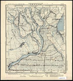
- Abstract:
- Modern area represented: Malbork, Poland
- Call Number:
- G7063.K2 s25 .S6 sheet N-34-63-C-c
- City:
- Мариенбург
- Copyright Holder:
- No Copyright - United States
- Country:
- Германия (Germany)
- Physical Description:
- Scale: 1:25,000
- Persistent URL:
- http://purl.dlib.indiana.edu/iudl/images/VAC9619/VAC9619-003786
- Provenance:
- M. I. Map Library
-
- Subject:
- Topical Subject: Maps, Topical Subject: Soviet Union, and Geographic Subject: Myszewo
- Publisher:
- Генеральный штаб Красной Армии
- Language:
- Russian
- Date Created:
- 1941
- Identifier:
- VAC9619-003785
- Genre:
- Topographic Maps and Military Maps
- Geographic Location:
- Coordinates: 54.083, 19.125, 54.167, 19.25
- Related URL:
- Catalog URL: https://iucat.iu.edu/catalog/14701157 and Download GeoTIFF: https://drive.google.com/file/d/1XadLTRStSNFshiBzZCO9r5wCAhaLTYqy/view?usp=sharing
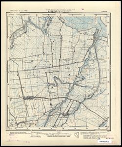
- Abstract:
- Modern area represented: Myszewo, Poland
- Call Number:
- G7063.K2 s25 .S6 sheet N-34-63-C-b
- City:
- Гросс Маусдорф (Gross Mausdorf)
- Copyright Holder:
- No Copyright - United States
- Country:
- Германия (Germany)
- Physical Description:
- Scale: 1:25,000
- Persistent URL:
- http://purl.dlib.indiana.edu/iudl/images/VAC9619/VAC9619-003785
- Provenance:
- M. I. Map Library
-
- Subject:
- Topical Subject: Soviet Union, Geographic Subject: Nowy Staw, and Topical Subject: Maps
- Publisher:
- Генеральный штаб Красной Армии
- Language:
- Russian
- Date Created:
- 1941
- Identifier:
- VAC9619-003784
- Genre:
- Topographic Maps and Military Maps
- Geographic Location:
- Coordinates: 54.083, 19, 54.167, 19.125
- Related URL:
- Download GeoTIFF: https://drive.google.com/file/d/1Sq9fVMvDmaoAlre3-zP3AuGktROnmii9/view?usp=sharing and Catalog URL: https://iucat.iu.edu/catalog/14701157
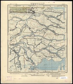
- Abstract:
- Modern area represented: Nowy Staw, Poland
- Call Number:
- G7063.K2 s25 .S6 sheet N-34-63-C-а
- City:
- Нойтайх (Neuteich)
- Copyright Holder:
- No Copyright - United States
- Country:
- Германия (Germany)
- Physical Description:
- Scale: 1:25,000
- Persistent URL:
- http://purl.dlib.indiana.edu/iudl/images/VAC9619/VAC9619-003784
- Provenance:
- CIA Map Branch -- Received
-
- Subject:
- Topical Subject: Maps, Geographic Subject: Elbląg, and Topical Subject: Soviet Union
- Publisher:
- Генеральный штаб Красной Армии
- Language:
- Russian
- Date Created:
- 1941
- Identifier:
- VAC9619-003783
- Genre:
- Military Maps and Topographic Maps
- Geographic Location:
- Coordinates: 54.167, 19.375, 54.25, 19.5
- Related URL:
- Download GeoTIFF: https://drive.google.com/file/d/1b2kxp8Acq6JkNcncigxWSdLSKx7IK959/view?usp=sharing and Catalog URL: https://iucat.iu.edu/catalog/14701157
- Abstract:
- Modern area represented: part of Elbląg, Poland
- Call Number:
- G7063.K2 s25 .S6 sheet N-34-63-B-d
- City:
- Пангриц-Кол (Pangritz-Kolonie)
- Copyright Holder:
- No Copyright - United States
- Country:
- Германия (Germany)
- Physical Description:
- Scale: 1:25,000
- Persistent URL:
- http://purl.dlib.indiana.edu/iudl/images/VAC9619/VAC9619-003783
- Provenance:
- M. I. Map Library
-
- Subject:
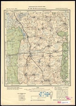
- Topical Subject: Maps, Geographic Subject: Kępki, and Topical Subject: Soviet Union
- Publisher:
- Генеральный штаб Красной Армии
- Language:
- Russian
- Date Created:
- 1941
- Identifier:
- VAC9619-003782
- Genre:
- Military Maps and Topographic Maps
- Geographic Location:
- Coordinates: 54.167, 19.25, 54.25, 19.375
- Related URL:
- Catalog URL: https://iucat.iu.edu/catalog/14701157 and Download GeoTIFF: https://drive.google.com/file/d/1SrLG238zrF6AKeHeXm0-yTy5GoRnwpno/view?usp=sharing
- Abstract:
- Modern area represented: Kępki, Poland
- Call Number:
- G7063.K2 s25 .S6 sheet N-34-63-B-c
- City:
- Цайер (Zeyer)
- Copyright Holder:
- No Copyright - United States
- Country:
- Германия (Germany)
- Physical Description:
- Scale: 1:25,000
- Persistent URL:
- http://purl.dlib.indiana.edu/iudl/images/VAC9619/VAC9619-003782
- Provenance:
- CIA Map Branch -- Received
-
- Subject:
- Topical Subject: Soviet Union, Geographic Subject: Marzęcino, and Topical Subject: Maps
- Publisher:
- Генеральный штаб Красной Армии
- Language:
- Russian
- Date Created:
- 1941
- Identifier:
- VAC9619-003781
- Genre:
- Military Maps and Topographic Maps
- Geographic Location:
- Coordinates: 54.167, 19.125, 54.25, 19.25
- Related URL:
- Download GeoTIFF: https://drive.google.com/file/d/1JHrB-S1z6MKK7fLMd5GRB8hrFkmk1RN5/view?usp=sharing and Catalog URL: https://iucat.iu.edu/catalog/14701157
- Abstract:
- Modern area represented: Marzęcino, Poland
- Call Number:
- G7063.K2 s25 .S6 sheet N-34-63-A-d
- City:
- Йюнгфер (Jungfer)
- Copyright Holder:
- No Copyright - United States
- Country:
- Германия (Germany)
- Physical Description:
- Scale: 1:25,000
- Persistent URL:
- http://purl.dlib.indiana.edu/iudl/images/VAC9619/VAC9619-003781
- Provenance:
- CIA Map Branch -- Received
-
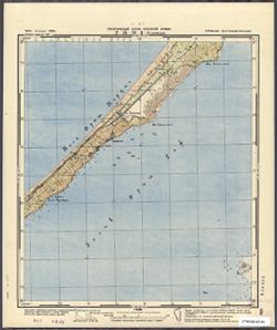
- Subject:
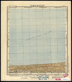
- Topical Subject: Soviet Union, Geographic Subject: Sztutowo, and Topical Subject: Maps
- Publisher:
- Генеральный штаб Красной Армии
- Language:
- Russian
- Date Created:
- 1941
- Identifier:
- VAC9619-003780
- Genre:
- Topographic Maps and Military Maps
- Geographic Location:
- Coordinates: 54.25, 19.125, 54.333, 19.25
- Related URL:
- Catalog URL: https://iucat.iu.edu/catalog/14701157 and Download GeoTIFF: https://drive.google.com/file/d/17dUXkuv4YY_CfvlhoYiPN_RG1L-Ds0QT/view?usp=sharing
- Abstract:
- Modern area represented: Sztutowo, Poland
- Call Number:
- G7063.K2 s25 .S6 sheet N-34-63-A-b
- City:
- Штуттхоф (Stutthof)
- Copyright Holder:
- No Copyright - United States
- Country:
- Германия (Germany)
- Physical Description:
- Scale: 1:25,000
- Persistent URL:
- http://purl.dlib.indiana.edu/iudl/images/VAC9619/VAC9619-003780
- Provenance:
- CIA Map Branch -- Received
-
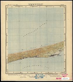
- Subject:
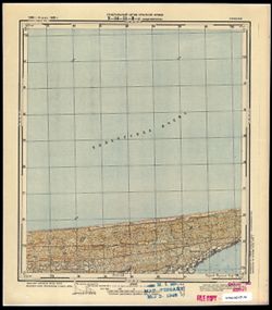
- Topical Subject: Soviet Union, Topical Subject: Maps, and Geographic Subject: Stegna
- Publisher:
- Генеральный штаб Красной Армии
- Language:
- Russian
- Date Created:
- 1941
- Identifier:
- VAC9619-003779
- Genre:
- Military Maps and Topographic Maps
- Geographic Location:
- Coordinates: 54.25, 19, 54.333, 19.125
- Related URL:
- Download GeoTIFF: https://drive.google.com/file/d/1OFTh9I5r9YumGdP0hxH4-EX_CYTQVLfu/view?usp=sharing and Catalog URL: https://iucat.iu.edu/catalog/14701157
- Abstract:
- Modern area represented: Stegna, Poland
- Call Number:
- G7063.K2 s25 .S6 sheet N-34-63-A-а
- City:
- Штееген (Steegen)
- Copyright Holder:
- No Copyright - United States
- Country:
- Германия (Germany)
- Physical Description:
- Scale: 1:25,000
- Persistent URL:
- http://purl.dlib.indiana.edu/iudl/images/VAC9619/VAC9619-003779
- Provenance:
- CIA Map Branch -- Received
-
- Subject:
- Geographic Subject: Bagrationovsk, Topical Subject: Maps, and Topical Subject: Soviet Union
- Publisher:
- Генеральный штаб Красной Армии
- Language:
- Russian
- Date Created:
- 1941
- Identifier:
- VAC9619-003746
- Genre:
- Military Maps and Topographic Maps
- Geographic Location:
- Coordinates: 54.3333, 20.625, 54.416667, 20.75
- Related URL:
- Download GeoTIFF: https://drive.google.com/file/d/1_09K1x3iGG35_Uo2XQW8nQtB_a94SkR8/view?usp=sharing and Catalog URL: https://iucat.iu.edu/catalog/14701157
- Abstract:
- Modern area represented: Bagrationovsk, Kaliningrad oblast, Russia
- Call Number:
- G7063.K2 s25 .S6 sheet N-34-54-C-d
- Caption:
- Captured map
- City:
- Прейсиш-Айлау (Preussisch-Eylau)
- Copyright Holder:
- No Copyright - United States
- Country:
- Восточная Пруссия (East Prussia) and Германия (Germany)
- Physical Description:
- Scale: 1:25,000
- Persistent URL:
- http://purl.dlib.indiana.edu/iudl/images/VAC9619/VAC9619-003746
- Provenance:
- Army Map Service Library, OMAHA, Library of Congress Geography & Map Division
-
- Subject:
- Topical Subject: Soviet Union, Geographic Subject: Narmeln, and Topical Subject: Maps
- Publisher:
- Генеральный штаб Красной Армии
- Language:
- Russian
- Date Created:
- 1941
- Identifier:
- VAC9619-003731
- Genre:
- Topographic Maps and Military Maps
- Geographic Location:
- Coordinates: 54.416667, 19.625, 54.5, 19.75
- Related URL:
- Catalog URL: https://iucat.iu.edu/catalog/14701157 and Download GeoTIFF: https://drive.google.com/file/d/1w6KAMpQmrtgzeErO2wKjNC0BH-hcU1W5/view?usp=sharing
- Abstract:
- Modern area represented: Narmeln, Kaliningrad oblast, Russia
- Call Number:
- G7063.K2 s25 .S6 sheet N-34-52-C-b
- City:
- Нармельн (Narmeln)
- Copyright Holder:
- No Copyright - United States
- Country:
- Германия (Germany) and Восточная Пруссия (East Prussia)
- Physical Description:
- Scale: 1:25,000
- Persistent URL:
- http://purl.dlib.indiana.edu/iudl/images/VAC9619/VAC9619-003731
- Provenance:
- CIA Map Branch -- Received
-
- Subject:
- Topical Subject: Maps, Topical Subject: Soviet Union, and Geographic Subject: Przebrno
- Publisher:
- Генеральный штаб Красной Армии
- Language:
- Russian
- Date Created:
- 1941
- Identifier:
- VAC9619-003726
- Genre:
- Military Maps and Topographic Maps
- Geographic Location:
- Coordinates: 54.333, 19.25, 54.417, 19.375
- Related URL:
- Download GeoTIFF: https://drive.google.com/file/d/1CLV6-QjLkr3uyiNtmTa1PIy0iQBKYM80/view?usp=sharing and Catalog URL: https://iucat.iu.edu/catalog/14701157
- Abstract:
- Modern area represented: Przebrno, part of the town of Krynica Morska, Poland
- Call Number:
- G7063.K2 s25 .S6 sheet N-34-51-D-c
- City:
- Преббернау (Pröbbernau)
- Copyright Holder:
- No Copyright - United States
- Country:
- Германия (Germany)
- Physical Description:
- Scale: 1:25,000
- Persistent URL:
- http://purl.dlib.indiana.edu/iudl/images/VAC9619/VAC9619-003726
- Provenance:
- M. I. Map Library
-
- Subject:
- Geographic Subject: Kąty Rybackie, Topical Subject: Soviet Union, and Topical Subject: Maps
- Publisher:
- Генеральный штаб Красной Армии
- Language:
- Russian
- Date Created:
- 1941
- Identifier:
- VAC9619-003725
- Genre:
- Topographic Maps and Military Maps
- Geographic Location:
- Coordinates: 54.333, 19.125, 54.417, 19.25
- Related URL:
- Download GeoTIFF: https://drive.google.com/file/d/1nthUYSIAKdjoclMMA8ArWuM2ha_r6Ch6/view?usp=sharing and Catalog URL: https://iucat.iu.edu/catalog/14701157
- Abstract:
- Modern area represented: Kąty Rybackie, Poland
- Call Number:
- G7063.K2 s25 .S6 sheet N-34-51-C-d
- City:
- Боденвинкель (Bodenwinkel)
- Copyright Holder:
- No Copyright - United States
- Country:
- Германия (Germany)
- Physical Description:
- Scale: 1:25,000
- Persistent URL:
- http://purl.dlib.indiana.edu/iudl/images/VAC9619/VAC9619-003725
- Provenance:
- M. I. Map Library
-
- Subject:
- Geographic Subject: Jantar, Topical Subject: Soviet Union, and Topical Subject: Maps
- Publisher:
- Генеральный штаб Красной Армии
- Language:
- Russian
- Date Created:
- 1941
- Identifier:
- VAC9619-003724
- Genre:
- Military Maps and Topographic Maps
- Geographic Location:
- Coordinates: 54.333, 19, 54.417, 19.125
- Related URL:
- Catalog URL: https://iucat.iu.edu/catalog/14701157 and Download GeoTIFF: https://drive.google.com/file/d/1XRXsOHSWk3V6ILdyPhcAPZc9s4tg6S4w/view?usp=sharing
- Abstract:
- Modern area represented: Jantar, Poland
- Call Number:
- G7063.K2 s25 .S6 sheet N-34-51-C-c
- City:
- Пазеварк (Pasewark)
- Copyright Holder:
- No Copyright - United States
- Country:
- Германия (Germany)
- Physical Description:
- Scale: 1:25,000
- Persistent URL:
- http://purl.dlib.indiana.edu/iudl/images/VAC9619/VAC9619-003724
- Provenance:
- M. I. Map Library
-
- Subject:
- Topical Subject: Maps, Geographic Subject: Gremyachye, and Topical Subject: Soviet Union
- Publisher:
- Генеральный штаб Красной Армии
- Language:
- Russian
- Date Created:
- 1941
- Identifier:
- VAC9619-003694
- Genre:
- Military Maps and Topographic Maps
- Geographic Location:
- Coordinates: 54.667, 21.625, 54.75, 21.75
- Related URL:
- Catalog URL: https://iucat.iu.edu/catalog/14701157 and Download GeoTIFF: https://drive.google.com/file/d/1KT2GrHhSTHNWfNPmFbtHfwPNejcPiMKa/view?usp=sharing
- Abstract:
- Modern area represented: Gremyachye, Kaliningrad oblast, Russia
- Call Number:
- G7063.K2 s25 .S6 sheet N-34-44-C-d
- City:
- Гросс Бершкаллен (Gross Berschkallen)
- Copyright Holder:
- No Copyright - United States
- Country:
- Восточная Пруссия (East Prussia) and Германия (Germany)
- Physical Description:
- Scale: 1:25,000
- Persistent URL:
- http://purl.dlib.indiana.edu/iudl/images/VAC9619/VAC9619-003694
- Provenance:
- M. I. Map Library, G000-30
-
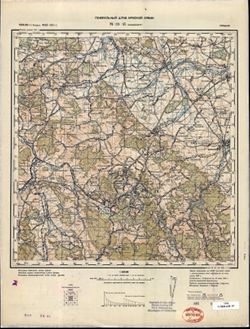
- Description:
- 1869
- Subject:
- Geographic Subject: Týniště nad Orlicí, Topical Subject: Soviet Union, and Topical Subject: Maps
- Publisher:
- Генеральный штаб Красной Армии
- Language:
- Russian
- Date Created:
- 1941
- Identifier:
- VAC9619-002677
- Genre:
- Topographic Maps and Military Maps
- Geographic Location:
- Coordinates: 50.0, 16.0, 50.3333, 16.5
- Related URL:
- Download GeoTIFF: https://drive.google.com/file/d/1DVUpsS9Unf_spFh6JK77AQKXw7ADjRAS/view?usp=sharing and Catalog URL: https://iucat.iu.edu/catalog/5020129
- Abstract:
- Modern area represented: Týniště nad Orlicí, Hradec Králové Region, Czech Republic
- Call Number:
- G7000 s100 .S7 sheet M-33-69
- City:
- Тыниште (Týniště)
- Copyright Holder:
- No Copyright - United States
- Country:
- Германия (Germany)
- State/Province:
- Протекторат Богемии и Моравии (Protectorate of Bohemia and Moravia)
- Physical Description:
- Scale: 1:100,000
- Persistent URL:
- http://purl.dlib.indiana.edu/iudl/images/VAC9619/VAC9619-002677
- Provenance:
- DMA Topographic Center, Army Map Service Library, Geographic Names Branch
-
- Description:
- 1881
- Subject:
- Topical Subject: Soviet Union, Topical Subject: Maps, and Geographic Subject: Broumov
- Publisher:
- Генеральный штаб Красной Армии
- Language:
- Russian
- Date Created:
- 1941
- Identifier:
- VAC9619-002673
- Genre:
- Military Maps and Topographic Maps
- Geographic Location:
- Coordinates: 50.3333, 16.0, 50.6667, 16.5
- Related URL:
- Catalog URL: https://iucat.iu.edu/catalog/5020129 and Download GeoTIFF: https://drive.google.com/file/d/1vL-_2yzJz51i8Sl-L7gVn481HG8bylvt/view?usp=sharing
- Abstract:
- Modern area represented: Broumov, Hradec Králové region, Czech Republic
- Call Number:
- G7000 s100 .S7 sheet M-33-57
- City:
- Браунау (Braunau)
- Copyright Holder:
- No Copyright - United States
- Country:
- Германия (Germany)
- State/Province:
- Протекторат Богемии и Моравии (Protectorate of Bohemia and Moravia)
- Physical Description:
- Scale: 1:100,000
- Persistent URL:
- http://purl.dlib.indiana.edu/iudl/images/VAC9619/VAC9619-002673
- Provenance:
- DMA Topographic Center, Army Map Service Library
-

- Description:
- 1881
- Subject:
- Topical Subject: Soviet Union, Topical Subject: Maps, and Geographic Subject: Wałbrzych
- Publisher:
- Генеральный штаб Красной Армии
- Language:
- Russian
- Date Created:
- 1941
- Identifier:
- VAC9619-002669
- Genre:
- Topographic Maps and Military Maps
- Geographic Location:
- Coordinates: 50.667, 16, 51, 16.5
- Related URL:
- Download GeoTIFF: https://drive.google.com/file/d/1dqILe5GxCSjBkAQ_koaLdjUsoxZylSen/view?usp=sharing and Catalog URL: https://iucat.iu.edu/catalog/5020129
- Abstract:
- Modern area represented: Wałbrzych, Lower Silesian province, Poland
- Call Number:
- G7000 s100 .S7 sheet M-33-45
- City:
- Вальденбург (Waldenburg)
- Copyright Holder:
- No Copyright - United States
- Country:
- Германия (Germany)
- Physical Description:
- Scale: 1:100,000
- Persistent URL:
- http://purl.dlib.indiana.edu/iudl/images/VAC9619/VAC9619-002669
- Provenance:
- DMA Topographic Center, Army Map Service Library
-
- Description:
- 1881
- Subject:
- Topical Subject: Maps, Geographic Subject: Wałbrzych, and Topical Subject: Soviet Union
- Publisher:
- Генеральный штаб Красной Армии
- Language:
- Russian
- Date Created:
- 1941
- Identifier:
- VAC9619-002612
- Genre:
- Topographic Maps and Military Maps
- Geographic Location:
- Coordinates: 50.66667, 16.0, 51.0, 16.5
- Related URL:
- Download GeoTIFF: https://drive.google.com/file/d/1kFsiMhki6AQE-SCAeAGcI3MVKvGeIKR4/view?usp=sharing and Catalog URL: https://iucat.iu.edu/catalog/5020129
- Abstract:
- Modern area represented: Wałbrzych, Lower Silesian province, Poland
- Call Number:
- G7000 s100 .S7 sheet M-33-45
- City:
- Вальденбург (Waldenburg)
- Copyright Holder:
- No Copyright - United States
- Country:
- Германия (Germany)
- Physical Description:
- Scale: 1:100,000
- Persistent URL:
- http://purl.dlib.indiana.edu/iudl/images/VAC9619/VAC9619-002612
- Provenance:
- DMA Topographic Center, Army Map Service Library, Library of Congress Geography & Map Division
-
- Description:
- 1881
- Subject:
- Topical Subject: Maps, Geographic Subject: Wałbrzych, and Topical Subject: Soviet Union
- Publisher:
- Генеральный штаб Красной Армии
- Language:
- Russian
- Date Created:
- 1941
- Identifier:
- VAC9619-002611
- Genre:
- Military Maps and Topographic Maps
- Geographic Location:
- Coordinates: 50.667, 16, 51, 16.5
- Related URL:
- Catalog URL: https://iucat.iu.edu/catalog/5020129 and Download GeoTIFF: https://drive.google.com/file/d/1YmxgsSmD507KrgT3JLU_e4j1QXzzCA3Y/view?usp=sharing
- Abstract:
- Modern area represented: Wałbrzych, Lower Silesian province, Poland
- Call Number:
- G7000 s100 .S7 sheet M-33-45
- City:
- Вальденбург (Waldenburg)
- Copyright Holder:
- No Copyright - United States
- Country:
- Германия (Germany)
- Physical Description:
- Scale: 1:100,000
- Persistent URL:
- http://purl.dlib.indiana.edu/iudl/images/VAC9619/VAC9619-002611
- Provenance:
- DMA Topographic Center, Library of Congress G & M Division, Army Map Service Library, OMAHA

- « Previous
- Next »
- 1
- 2
- 3
- 4