
Search Constraints
Search Results
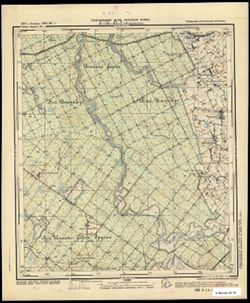
-

- Description:
- 1926
- Subject:
- Geographic Subject: Balky, Topical Subject: Soviet Union, and Topical Subject: Maps
- Publisher:
- Генеральный штаб Красной Армии
- Language:
- Russian
- Date Created:
- 1941
- Identifier:
- VAC9619-001868
- Genre:
- Topographic Maps and Military Maps
- Geographic Location:
- Coordinates: 47.3333, 34.5, 47.6667, 35
- Related URL:
- Catalog URL: https://iucat.iu.edu/catalog/5020129 and Download GeoTIFF: https://drive.google.com/open?id=1V7PHm7Dg5ABV8yybrFeMKAmxM9f2EO27
- Abstract:
- Modern area represented: Balky, Zaporizhia oblast, Ukraine
- Call Number:
- G7000 s100 .S7 sheet L-36-22
- Caption:
- Для служебного пользования
- City:
- Балки (Balky)
- Copyright Holder:
- No Copyright - United States
- Country:
- СССР (USSR)
- State/Province:
- Украинская ССР (Ukrainian Soviet Socialist Republic)
- Physical Description:
- Scale: 1:100,000
- Persistent URL:
- http://purl.dlib.indiana.edu/iudl/images/VAC9619/VAC9619-001868
- Provenance:
- CIA Map Library
-

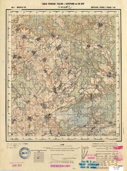
- Description:
- 1938
- Subject:
- Topical Subject: Maps, Geographic Subject: Krasnogvardeyskoe, and Topical Subject: Soviet Union
- Publisher:
- Главное управление геодезии и картографии при СНК СССР
- Language:
- Russian
- Date Created:
- 1941
- Identifier:
- VAC9619-002343
- Genre:
- Topographic Maps and Military Maps
- Geographic Location:
- Coordinates: 45.667, 41.5, 46, 42
- Related URL:
- Download GeoTIFF: https://drive.google.com/file/d/1AVr-cwCpH2TyChEw-jxKdVkFJnNQ8ff2/view?usp=sharing and Catalog URL: https://iucat.iu.edu/catalog/5020129
- Abstract:
- Modern area represented: Krasnogvardeyskoe, Stavropol kray, Russia
- Call Number:
- G7000 s100 .S7 sheet L-37-84
- Caption:
- Для служебного пользования
- City:
- Молотовское (Molotovskoe)
- Copyright Holder:
- No Copyright - United States
- Country:
- СССР (USSR)
- State/Province:
- Орджоникидзевский край (Ordzhonikidze kray), Калмыцкая АССР (Kalmyk Autonomous Soviet Socialist Republic), Ростовская область (Rostov oblast), and РСФСР (RSFSR)
- Physical Description:
- Scale: 1:100,000
- Persistent URL:
- http://purl.dlib.indiana.edu/iudl/images/VAC9619/VAC9619-002343
- Provenance:
- DMA Topographic Center, Army Map Service Library, OMAHA
-

- Description:
- 1939
- Subject:
- Topical Subject: Maps, Geographic Subject: Yukhnov, and Topical Subject: Soviet Union
- Publisher:
- Генеральный штаб Красной Армии
- Language:
- Russian
- Date Created:
- 1941
- Identifier:
- VAC9619-004187
- Genre:
- Topographic Maps and Military Maps
- Geographic Location:
- Coordinates: 54.667, 35, 55, 35.5
- Related URL:
- Download GeoTIFF: https://drive.google.com/file/d/1cQNBivSSzsjyVCwoyr6v2BrCZDWttVf4/view?usp=sharing and Catalog URL: https://iucat.iu.edu/catalog/5020129
- Abstract:
- Modern area represented: Yukhnov, Kaluga oblast, Russia
- Call Number:
- G7000 s100 .S7 sheet N-36-47
- City:
- Юхнов (Yukhnov)
- Copyright Holder:
- No Copyright - United States
- Country:
- СССР (USSR)
- State/Province:
- Смоленская область (Smolensk oblast) and РСФСР (RSFSR)
- Physical Description:
- Scale: 1:100,000
- Persistent URL:
- http://purl.dlib.indiana.edu/iudl/images/VAC9619/VAC9619-004187
- Provenance:
- DMA Topographic Center, Army Map Service Library, OMAHA
-
- Subject:
- Topical Subject: Soviet Union, Geographic Subject: Iskrovo, and Topical Subject: Maps
- Publisher:
- Генеральный штаб Красной Армии
- Language:
- Russian
- Date Created:
- 1941
- Identifier:
- VAC9619-003679
- Genre:
- Military Maps and Topographic Maps
- Geographic Location:
- Coordinates: 54.75, 21.375, 54.833, 21.5
- Related URL:
- Download GeoTIFF: https://drive.google.com/file/d/1yu7MH4jFLldg0pLFCOFpgBlt6_SbUA89/view?usp=sharing and Catalog URL: https://iucat.iu.edu/catalog/14701157
- Abstract:
- Modern area represented: part of Искрово (Iskrovo), Kaliningradskaya oblast, Russia
- Call Number:
- G7063.K2 s25 .S6 sheet N-34-43-D-b
- City:
- Паннауген
- Copyright Holder:
- No Copyright - United States
- Country:
- Германия (Восточная Пруссия) (Germany (East Prussia))
- Physical Description:
- Scale: 1:25,000
- Persistent URL:
- http://purl.dlib.indiana.edu/iudl/images/VAC9619/VAC9619-003679
- Provenance:
- CIA Map Branch -- Received
-

- Description:
- 1937
- Subject:
- Geographic Subject: Gummolovo and Topical Subject: Soviet Union
- Publisher:
- Главное управление государственной съемки и картографии НКВД СССР
- Language:
- Russian
- Date Created:
- 1941
- Identifier:
- VAC9619-000040
- Genre:
- Military Maps and Topographic Maps
- Geographic Location:
- Coordinates: 59.1667, 30.75, 59.3333, 31
- Related URL:
- Catalog URL: http://iucat.iu.edu/catalog/5020131 and Download GeoTIFF: https://drive.google.com/open?id=1Thglq8S3ntpZfPmHWFNFQ1QHmQpoR5Lu
- Abstract:
- Modern area represented: Gummolovo, Russia
- Call Number:
- G7000 s50 .S68 sheet O-36-26-B
- Caption:
- Для служебного пользования
- City:
- Гуммолово (Gummolovo)
- Copyright Holder:
- No Copyright - United States
- Country:
- СССР (USSR)
- State/Province:
- Ленинградская область (Leningrad oblast), Тосненский район (Tosnensky district), and РСФСР (RSFSR)
- Physical Description:
- Scale: 1:50,000
- Persistent URL:
- http://purl.dlib.indiana.edu/iudl/images/VAC9619/VAC9619-000040
- Provenance:
- Army Map Service Library, OMAHA, Library of Congress Geography & Map Division
-

- Description:
- 1933
- Subject:
- Topical Subject: Soviet Union, Geographic Subject: Taman, and Topical Subject: Maps
- Publisher:
- Генеральный штаб Красной Армии
- Language:
- Russian
- Date Created:
- 1941
- Identifier:
- VAC9619-002358
- Genre:
- Topographic Maps and Military Maps
- Geographic Location:
- Coordinates: 45, 36.5, 45.333, 37
- Related URL:
- Download GeoTIFF: https://drive.google.com/file/d/1X763anMOD-wQf-npLvv0Rk-_nGzkuqHb/view?usp=sharing and Catalog URL: https://iucat.iu.edu/catalog/5020129
- Abstract:
- Modern area represented: Taman, Russia
- Call Number:
- G7000 s100 .S7 sheet L-37-98
- Caption:
- Для служебного пользования
- City:
- Тамань (Taman)
- Copyright Holder:
- No Copyright - United States
- Country:
- СССР (USSR)
- State/Province:
- РСФСР (RSFSR) and Краснодарский край (Krasnodar kray)
- Physical Description:
- Scale: 1:100,000
- Persistent URL:
- http://purl.dlib.indiana.edu/iudl/images/VAC9619/VAC9619-002358
- Provenance:
- DMA Topographic Center, Army Map Service Library, Library of Congress Geography & Map Division
-
- Subject:
- Topical Subject: Soviet Union, Geographic Subject: Radzymin, and Topical Subject: Maps
- Publisher:
- Генеральный штаб Красной Армии
- Language:
- Russian
- Date Created:
- 1941
- Identifier:
- VAC9619-000261
- Genre:
- Topographic Maps and Military Maps
- Geographic Location:
- Coordinates: 52.3333, 21, 52.5, 21.25
- Related URL:
- Download GeoTIFF: https://drive.google.com/open?id=1MGqJ3x9il9JlEmFwvpxgnBaQh9vtG1hD and Catalog URL: http://iucat.iu.edu/catalog/5020131
- Abstract:
- Modern area represented: Radzymin, Poland
- Call Number:
- G7000 s50 .S68 sheet N-34-127-C
- Caption:
- Captured map
- City:
- Радзымин (Radzymin)
- Copyright Holder:
- No Copyright - United States
- Country:
- Область государственных интересов Германии (Region of German state interest)
- Physical Description:
- Scale: 1:50,000
- Persistent URL:
- http://purl.dlib.indiana.edu/iudl/images/VAC9619/VAC9619-000261
- Provenance:
- Army Map Service Library, Library of Congress Geography & Map Division
-
- Subject:
- Topical Subject: Soviet Union, Geographic Subject: Lipitsy, and Topical Subject: Maps
- Publisher:
- Генеральный штаб Красной Армии
- Language:
- Russian
- Date Created:
- 1941
- Identifier:
- VAC9619-003149
- Genre:
- Military Maps and Topographic Maps
- Geographic Location:
- Coordinates: 53.333, 37, 53.667, 37.5
- Related URL:
- Catalog URL: https://iucat.iu.edu/catalog/5020129 and Download GeoTIFF: https://drive.google.com/file/d/1DEJf3klsNOB3iIRfqpOPFMpm2cBBmWTF/view?usp=sharing
- Abstract:
- Modern area represented: Lipitsy, Tula oblast, Russia
- Call Number:
- G7000 s100 .S7 sheet N-37-87
- City:
- Липицы (Lipitsy)
- Copyright Holder:
- No Copyright - United States
- Country:
- СССР (USSR)
- State/Province:
- Тульская область (Tula oblast) and РСФСР (RSFSR)
- Physical Description:
- Scale: 1:100,000
- Persistent URL:
- http://purl.dlib.indiana.edu/iudl/images/VAC9619/VAC9619-003149
- Provenance:
- Army Map Service Library, Library of Congress G & M Division
-
- Description:
- 1939
- Subject:
- Geographic Subject: Lushchikovo, Topical Subject: Soviet Union, and Topical Subject: Maps
- Publisher:
- Главное Управление Геодезии и Картографии при СНК СССР
- Language:
- Russian
- Date Created:
- 1941
- Identifier:
- VAC9619-001316
- Genre:
- Topographic Maps and Military Maps
- Geographic Location:
- Coordinates: 54.667, 33.5, 54.833, 33.75
- Related URL:
- Download GeoTIFF: https://drive.google.com/open?id=1QqwkbeqMxBP_h4g_YQjctsz1Sdi9nkJC and Catalog URL: http://iucat.iu.edu/catalog/5020131
- Abstract:
- Modern area represented: Lushchikovo, Smolensk oblast, Russia
- Call Number:
- GM G7000 S50 .S68 N-36-44-C
- Copyright Holder:
- No Copyright - United States
- Country:
- СССР (USSR)
- State/Province:
- РСФСР (RSFSR) and Смоленская область (Smolensk oblast)
- Physical Description:
- Scale: 1:50,000
- Persistent URL:
- http://purl.dlib.indiana.edu/iudl/images/VAC9619/VAC9619-001316
- Provenance:
- M. I. Map Library, G000-30, CIA Map Library
-

- Description:
- 1939
- Subject:
- Topical Subject: Soviet Union, Geographic Subject: Komyshuvakha, and Topical Subject: Maps
- Publisher:
- Генеральный штаб Красной Армии
- Language:
- Russian
- Date Created:
- 1941
- Identifier:
- VAC9619-001844
- Genre:
- Military Maps and Topographic Maps
- Geographic Location:
- Coordinates: 47.6667, 35.5, 48, 36
- Related URL:
- Download GeoTIFF: https://drive.google.com/open?id=1IiavgxI6IZ79dkMzQI3jHmPsU86TTxOH and Catalog URL: https://iucat.iu.edu/catalog/5020129
- Abstract:
- Modern area represented: Komyshuvakha, Zaporizhia oblast, Ukraine
- Call Number:
- G7000 s100 .S7 sheet L-36-12
- Caption:
- Для служебного пользования
- City:
- Камышуваха (Komyshuvakha)
- Copyright Holder:
- No Copyright - United States
- Country:
- СССР (USSR)
- State/Province:
- Запорожская область (Zaporizhia oblast) and Украинская ССР (Ukrainian Soviet Socialist Republic)
- Physical Description:
- Scale: 1:100,000
- Persistent URL:
- http://purl.dlib.indiana.edu/iudl/images/VAC9619/VAC9619-001844
- Provenance:
- CIA Map Library
