
Search Constraints
You searched for:
Country
СССР (USSR)
Remove constraint Country: СССР (USSR)
Type
Image
Remove constraint Type: Image
State/Province
Украинская ССР (Ukrainian Soviet Socialist Republic)
Remove constraint State/Province: Украинская ССР (Ukrainian Soviet Socialist Republic)
Search Results
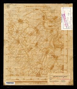
-
- Description:
- 1916
- Subject:
- Topical Subject: Maps, Topical Subject: Soviet Union, and Geographic Subject: Stavishche
- Publisher:
- Генеральный штаб Красной Армии
- Language:
- Russian
- Date Created:
- 1941
- Identifier:
- VAC9619-003299
- Genre:
- Topographic Maps and Military Maps
- Geographic Location:
- Coordinates: 51.333, 24, 51.667, 24.5
- Related URL:
- Catalog URL: https://iucat.iu.edu/catalog/5020129 and Download GeoTIFF: https://drive.google.com/file/d/1SyfPEGMvnxF2kmxo2OIir7gXTPMzO2jA/view?usp=sharing
- Abstract:
- Modern area represented: Stavishche, Kiev oblast, Ukraine
- Call Number:
- G7000 s100 .S7 sheet M-36-85
- Caption:
- Для служебного пользования
- City:
- Ставище (Stavishche)
- Copyright Holder:
- No Copyright - United States
- Country:
- СССР (USSR)
- State/Province:
- Киевская область (Kyiv oblast) and Украинская ССР (Ukrainian Soviet Socialist Republic)
- Physical Description:
- Scale: 1:100,000
- Persistent URL:
- http://purl.dlib.indiana.edu/iudl/images/VAC9619/VAC9619-003299
- Provenance:
- DMA Topographic Center, Army Map Service Library, OMAHA, Library of Congress Geography & Map Division
-

- Description:
- 1923
- Subject:
- Topical Subject: Soviet Union, Topical Subject: Maps, and Geographic Subject: Kaniv
- Publisher:
- Генеральный штаб Красной Армии
- Language:
- Russian
- Date Created:
- 1938
- Identifier:
- VAC9619-003298
- Genre:
- Topographic Maps and Military Maps
- Geographic Location:
- Coordinates: 49.667, 31, 50, 31.5
- Related URL:
- Catalog URL: https://iucat.iu.edu/catalog/5020129 and Download GeoTIFF: https://drive.google.com/file/d/18uFdqJKy1Up9JM9AnfY5uG9_XJZ7gI2l/view?usp=sharing
- Abstract:
- Modern area represented: Kaniv, Cherkasy oblast, Ukraine
- Call Number:
- G7000 s100 .S7 sheet M-36-75
- Caption:
- Для служебного пользования
- City:
- Канев (Kaniv)
- Copyright Holder:
- No Copyright - United States
- Country:
- СССР (USSR)
- State/Province:
- Украинская ССР (Ukrainian Soviet Socialist Republic) and Киевская область (Kyiv oblast)
- Physical Description:
- Scale: 1:100,000
- Persistent URL:
- http://purl.dlib.indiana.edu/iudl/images/VAC9619/VAC9619-003298
- Provenance:
- DMA Topographic Center, Army Map Service Library, OMAHA, Library of Congress Geography & Map Division
-
- Description:
- 1931
- Subject:
- Topical Subject: Soviet Union, Geographic Subject: Velyki Sorochyntsi, and Topical Subject: Maps
- Publisher:
- Генеральный штаб Красной Армии
- Language:
- Russian
- Date Created:
- 1941
- Identifier:
- VAC9619-003297
- Genre:
- Topographic Maps and Military Maps
- Geographic Location:
- Coordinates: 50, 33.5, 50.333, 34
- Related URL:
- Catalog URL: https://iucat.iu.edu/catalog/5020129 and Download GeoTIFF: https://drive.google.com/file/d/1qDvVPmrcSf6D1G2_0mVthF1MJMKHSLXb/view?usp=sharing
- Abstract:
- Modern area represented: Velyki Sorochyntsi, Poltava oblast, Ukraine
- Call Number:
- G7000 s100 .S7 sheet M-36-68
- City:
- Сорочинцы (Sorochyntsi)
- Copyright Holder:
- No Copyright - United States
- Country:
- СССР (USSR)
- State/Province:
- Украинская ССР (Ukrainian Soviet Socialist Republic) and Полтавская область (Poltava oblast)
- Physical Description:
- Scale: 1:100,000
- Persistent URL:
- http://purl.dlib.indiana.edu/iudl/images/VAC9619/VAC9619-003297
- Provenance:
- DMA Topographic Center, Army Map Service Library, OMAHA, Library of Congress Geography & Map Division
-
- Description:
- 1931
- Subject:
- Topical Subject: Maps, Geographic Subject: Lubny, and Topical Subject: Soviet Union
- Publisher:
- Генеральный штаб Красной Армии
- Language:
- Russian
- Date Created:
- 1941
- Identifier:
- VAC9619-003296
- Genre:
- Topographic Maps and Military Maps
- Geographic Location:
- Coordinates: 50, 33, 50.333, 33.5
- Related URL:
- Catalog URL: https://iucat.iu.edu/catalog/5020129 and Download GeoTIFF: https://drive.google.com/file/d/1aCmmT142IH6eTopGWA96mJuxqrZheVAF/view?usp=sharing
- Abstract:
- Modern area represented: Lubny, Poltava oblast, Ukraine
- Call Number:
- G7000 s100 .S7 sheet M-36-67
- City:
- Лубны (Lubny)
- Copyright Holder:
- No Copyright - United States
- Country:
- СССР (USSR)
- State/Province:
- Полтавская область (Poltava oblast) and Украинская ССР (Ukrainian Soviet Socialist Republic)
- Physical Description:
- Scale: 1:100,000
- Persistent URL:
- http://purl.dlib.indiana.edu/iudl/images/VAC9619/VAC9619-003296
- Provenance:
- DMA Topographic Center, Army Map Service Library
-
- Description:
- 1931
- Subject:
- Geographic Subject: Pyryatyn, Topical Subject: Soviet Union, and Topical Subject: Maps
- Publisher:
- Генеральный штаб Красной Армии
- Language:
- Russian
- Date Created:
- 1941
- Identifier:
- VAC9619-003295
- Genre:
- Military Maps and Topographic Maps
- Geographic Location:
- Coordinates: 50, 32.5, 50.333, 33
- Related URL:
- Catalog URL: https://iucat.iu.edu/catalog/5020129 and Download GeoTIFF: https://drive.google.com/file/d/1HdqPsI9WrCB8MDCw6W1C7HsKViFRcI5T/view?usp=sharing
- Abstract:
- Modern area represented: Pyryatyn, Poltava oblast, Ukraine
- Call Number:
- G7000 s100 .S7 sheet M-36-66
- City:
- Пирятин (Pyryatyn)
- Copyright Holder:
- No Copyright - United States
- Country:
- СССР (USSR)
- State/Province:
- Украинская ССР (Ukrainian Soviet Socialist Republic) and Полтавская область (Poltava oblast)
- Physical Description:
- Scale: 1:100,000
- Persistent URL:
- http://purl.dlib.indiana.edu/iudl/images/VAC9619/VAC9619-003295
- Provenance:
- DMA Topographic Center, Army Map Service Library, OMAHA, Library of Congress Geography & Map Division
-
- Subject:
- Topical Subject: Maps, Geographic Subject: Hrebinka, and Topical Subject: Soviet Union
- Publisher:
- Генеральный штаб Красной Армии
- Language:
- Russian
- Identifier:
- VAC9619-003294
- Genre:
- Military Maps and Topographic Maps
- Geographic Location:
- Coordinates: 50, 32, 50.5, 32.5
- Related URL:
- Catalog URL: https://iucat.iu.edu/catalog/5020129 and Download GeoTIFF: https://drive.google.com/file/d/1o_CCKouW8G2bUf6ptlUF8Am6lslsladg/view?usp=sharing
- Abstract:
- Modern area represented: Hrebinka, Poltava oblast, Ukraine
- Call Number:
- G7000 s100 .S7 sheet M-36-65
- City:
- Гребенка (Hrebinka)
- Copyright Holder:
- No Copyright - United States
- Country:
- СССР (USSR)
- State/Province:
- Полтавская область (Poltava oblast) and Украинская ССР (Ukrainian Soviet Socialist Republic)
- Physical Description:
- Scale: 1:100,000
- Persistent URL:
- http://purl.dlib.indiana.edu/iudl/images/VAC9619/VAC9619-003294
- Provenance:
- DMA Topographic Center, Army Map Service Library
-

- Description:
- 1928
- Subject:
- Topical Subject: Soviet Union, Geographic Subject: Yahotyn, and Topical Subject: Maps
- Publisher:
- Генеральный штаб Красной Армии
- Language:
- Russian
- Date Created:
- 1941
- Identifier:
- VAC9619-003293
- Genre:
- Topographic Maps and Military Maps
- Geographic Location:
- Coordinates: 50, 31.5, 50.333, 32
- Related URL:
- Catalog URL: https://iucat.iu.edu/catalog/5020129 and Download GeoTIFF: https://drive.google.com/file/d/1LHmrE7SLHHk3jOpjngs2HIPoYbavjsT9/view?usp=sharing
- Abstract:
- Modern area represented: Yahotyn, Kiev oblast, Ukraine
- Call Number:
- G7000 s100 .S7 sheet M-36-64
- City:
- Яготин (Yahotyn)
- Copyright Holder:
- No Copyright - United States
- Country:
- СССР (USSR)
- State/Province:
- Черниговская область (Chernihiv oblast), Киевская область (Kyiv oblast), Украинская ССР (Ukrainian Soviet Socialist Republic), and Полтавская область (Poltav...
- Physical Description:
- Scale: 1:100,000
- Persistent URL:
- http://purl.dlib.indiana.edu/iudl/images/VAC9619/VAC9619-003293
- Provenance:
- DMA Topographic Center, Army Map Service Library, OMAHA, Library of Congress Geography & Map Division
-
- Description:
- 1923
- Subject:
- Topical Subject: Maps, Topical Subject: Soviet Union, and Geographic Subject: Obukhiv
- Publisher:
- Генеральный штаб РККА
- Language:
- Russian
- Date Created:
- 1932
- Identifier:
- VAC9619-003292
- Genre:
- Topographic Maps and Military Maps
- Geographic Location:
- Coordinates: 50, 30.5, 50.333, 31
- Related URL:
- Download GeoTIFF: https://drive.google.com/file/d/1IKU5S1he-loKUI7NMcg8yD1GeraYdNob/view?usp=sharing and Catalog URL: https://iucat.iu.edu/catalog/5020129
- Abstract:
- Modern area represented: Obukhiv, Kiev oblast, Ukraine
- Call Number:
- G7000 s100 .S7 sheet M-36-62
- Caption:
- Для служебного пользования
- City:
- Обухов (Obukhiv)
- Copyright Holder:
- No Copyright - United States
- Country:
- СССР (USSR)
- State/Province:
- Киевская область (Kyiv oblast) and Украинская ССР (Ukrainian Soviet Socialist Republic)
- Physical Description:
- Scale: 1:100,000
- Persistent URL:
- http://purl.dlib.indiana.edu/iudl/images/VAC9619/VAC9619-003292
- Provenance:
- DMA Topographic Center, Army Map Service Library, OMAHA, Library of Congress Geography & Map Division
-
- Description:
- 1939
- Subject:
- Topical Subject: Maps, Topical Subject: Soviet Union, and Geographic Subject: Lebedyn
- Publisher:
- Главное Управление Геодезии и Картографии при СНК СССР
- Language:
- Russian
- Date Created:
- 1941
- Identifier:
- VAC9619-003291
- Genre:
- Topographic Maps and Military Maps
- Geographic Location:
- Coordinates: 50.333, 34, 50.667, 34.5
- Related URL:
- Download GeoTIFF: https://drive.google.com/file/d/1LH-VIY4AgCDRAVv0BsyXHDXLxYcQ3MnF/view?usp=sharing and Catalog URL: https://iucat.iu.edu/catalog/5020129
- Abstract:
- Modern area represented: Lebedyn, Sumy oblast, Ukraine
- Call Number:
- G7000 s100 .S7 sheet M-36-57
- City:
- Лебедин (Lebedyn)
- Copyright Holder:
- No Copyright - United States
- Country:
- СССР (USSR)
- State/Province:
- Полтавская область (Poltava oblast), Украинская ССР (Ukrainian Soviet Socialist Republic), and Сумская область (Sumy oblast)
- Physical Description:
- Scale: 1:100,000
- Persistent URL:
- http://purl.dlib.indiana.edu/iudl/images/VAC9619/VAC9619-003291
- Provenance:
- DMA Topographic Center, Army Map Service Library, University of Kansas Map Library
-
- Description:
- 1931
- Subject:
- Topical Subject: Soviet Union, Topical Subject: Maps, and Geographic Subject: Hadyach
- Publisher:
- Генеральный штаб Красной Армии
- Language:
- Russian
- Date Created:
- 1940
- Identifier:
- VAC9619-003290
- Genre:
- Topographic Maps and Military Maps
- Geographic Location:
- Coordinates: 50.333, 33.5, 50.667, 34
- Related URL:
- Catalog URL: https://iucat.iu.edu/catalog/5020129 and Download GeoTIFF: https://drive.google.com/file/d/1EDC4W8qM2G0fPvEY__GirQ2Q4YwJdYpe/view?usp=sharing
- Abstract:
- Modern area represented: Hadyach, Poltava oblast, Ukraine
- Call Number:
- G7000 s100 .S7 sheet M-36-56
- City:
- Гадяч (Hadyach)
- Copyright Holder:
- No Copyright - United States
- Country:
- СССР (USSR)
- State/Province:
- Украинская ССР (Ukrainian Soviet Socialist Republic), Полтавская область (Poltava oblast), and Сумская область (Sumy oblast)
- Physical Description:
- Scale: 1:100,000
- Persistent URL:
- http://purl.dlib.indiana.edu/iudl/images/VAC9619/VAC9619-003290
- Provenance:
- DMA Topographic Center, Army Map Service Library, OMAHA, Library of Congress Geography & Map Division
