
Search Constraints
You searched for:
Publisher
Управление военных топографов РККА
Remove constraint Publisher: Управление военных топографов РККА
Search Results
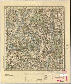
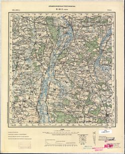
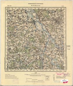
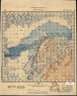
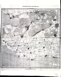
-
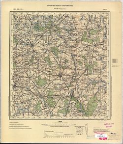
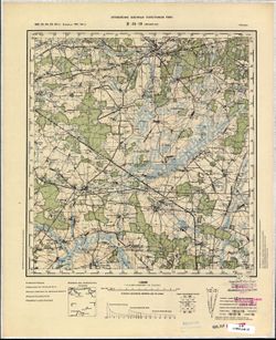
- Description:
- 1890
- Subject:
- Geographic Subject: Brzeziny, Topical Subject: Maps, and Topical Subject: Soviet Union
- Publisher:
- Управление военных топографов РККА
- Language:
- Russian
- Date Created:
- 1902
- Identifier:
- VAC9619-002725
- Genre:
- Military Maps and Topographic Maps
- Geographic Location:
- Coordinates: 51.667, 19.5, 52, 20
- Related URL:
- Catalog URL: https://iucat.iu.edu/catalog/5020129 and Download GeoTIFF: https://drive.google.com/file/d/15lz3-vA1V0dBg-vTebutySku1NEiAaeM/view?usp=sharing
- Abstract:
- Modern area represented: Brzeziny, Łódź province, Poland
- Call Number:
- G7000 s100 .S7 sheet M-34-4
- City:
- Бжезины (Brzeziny)
- Copyright Holder:
- No Copyright - United States
- Country:
- Польша (Poland)
- Physical Description:
- Scale: 1:100,000
- Persistent URL:
- http://purl.dlib.indiana.edu/iudl/images/VAC9619/VAC9619-002725
- Provenance:
- CIA Map Library
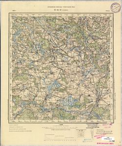
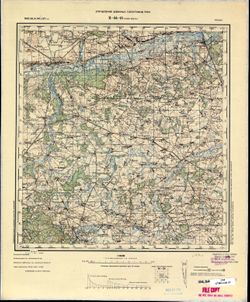
-
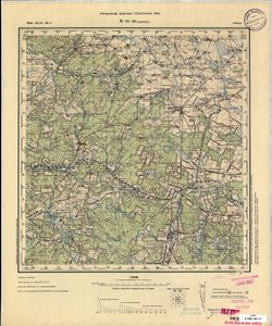
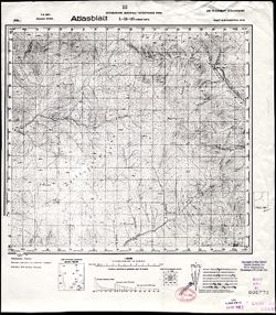
- Subject:
- Geographic Subject: Рівне (Rivne), Topical Subject: Maps, and Topical Subject: Soviet Union
- Publisher:
- Управление военных топографов РККА
- Language:
- Russian
- Identifier:
- VAC9619-000171
- Genre:
- Topographic Maps and Military Maps
- Geographic Location:
- Coordinates: 51.1667, 23.75, 51.3333, 24
- Related URL:
- Download GeoTIFF: https://drive.google.com/open?id=1n9lPW8npnqsPg0Z2PuZi0QWMjWwr3IB_ and Catalog URL: http://iucat.iu.edu/catalog/5020131
- Abstract:
- Modern area represented: Rivne, Ukraine
- Call Number:
- G7000 s50 .S68 sheet M-34-36-B
- City:
- Рувно (Równo)
- Copyright Holder:
- No Copyright - United States
- Country:
- Польша (Poland)
- Physical Description:
- Scale: 1:50,000
- Persistent URL:
- http://purl.dlib.indiana.edu/iudl/images/VAC9619/VAC9619-000171
- Provenance:
- DMA Topographic Center, Army Map Service Library, OMAHA, Library of Congress Geography & Map Division
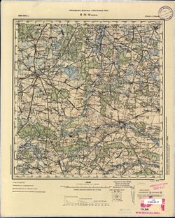
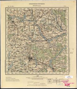
-
- Description:
- 1894
- Subject:
- Topical Subject: Soviet Union, Geographic Subject: Szydłowiec, and Topical Subject: Maps
- Publisher:
- Управление военных топографов РККА
- Language:
- Russian
- Date Created:
- 1898
- Identifier:
- VAC9619-002772
- Genre:
- Military Maps and Topographic Maps
- Geographic Location:
- Coordinates: 51, 20.5, 51.333, 21
- Related URL:
- Catalog URL: https://iucat.iu.edu/catalog/5020129 and Download GeoTIFF: https://drive.google.com/file/d/1Yr70Rfx37tnwSAVczZeNLS7M3LtaXmlX/view?usp=sharing
- Abstract:
- Modern area represented: Szydłowiec, Mazovia province, Poland
- Call Number:
- G7000 s100 .S7 sheet M-34-30
- City:
- Шидловец (Szydłowiec)
- Copyright Holder:
- No Copyright - United States
- Country:
- Польша (Poland)
- Physical Description:
- Scale: 1:100,000
- Persistent URL:
- http://purl.dlib.indiana.edu/iudl/images/VAC9619/VAC9619-002772
- Provenance:
- CIA Map Library, Geogr. Seminar Stuttgart
-
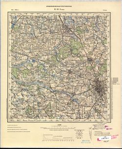
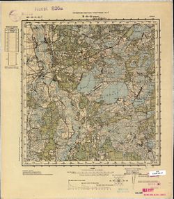
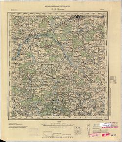
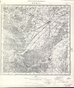
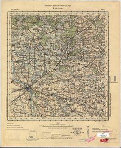
- Description:
- 1901
- Subject:
- Topical Subject: Soviet Union, Geographic Subject: Łódź, and Topical Subject: Maps
- Publisher:
- Управление военных топографов РККА
- Language:
- Russian
- Date Created:
- 1902
- Identifier:
- VAC9619-002723
- Genre:
- Topographic Maps and Military Maps
- Geographic Location:
- Coordinates: 51.667, 19, 52, 19.5
- Related URL:
- Download GeoTIFF: https://drive.google.com/file/d/1Mp3idgnooJzivr0VRYBpRjKnY9HgZlRG/view?usp=sharing and Catalog URL: https://iucat.iu.edu/catalog/5020129
- Abstract:
- Modern area represented: Łódź, Łódź province, Poland
- Call Number:
- G7000 s100 .S7 sheet M-34-3
- City:
- Лодзь (Łódź)
- Copyright Holder:
- No Copyright - United States
- Country:
- Польша (Poland)
- Physical Description:
- Scale: 1:100,000
- Persistent URL:
- http://purl.dlib.indiana.edu/iudl/images/VAC9619/VAC9619-002723
- Provenance:
- CIA Map Library
-
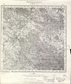
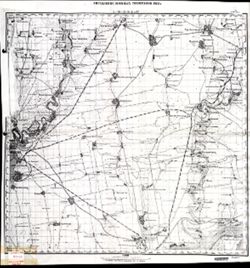
- Description:
- 1893
- Subject:
- Geographic Subject: Gmina Przedbórz, Topical Subject: Maps, and Topical Subject: Soviet Union
- Publisher:
- Управление военных топографов РККА
- Language:
- Russian
- Date Created:
- 1899
- Identifier:
- VAC9619-002768
- Genre:
- Military Maps and Topographic Maps
- Geographic Location:
- Coordinates: 51, 19.5, 51.333, 20
- Related URL:
- Download GeoTIFF: https://drive.google.com/file/d/1M_2ykSCyIgEOuJq47FQzQExuJVUKHDPI/view?usp=sharing and Catalog URL: https://iucat.iu.edu/catalog/5020129
- Abstract:
- Modern area represented: Gmina Przedbórz, Łódź province, Poland
- Call Number:
- G7000 s100 .S7 sheet M-34-28
- City:
- Пшедбуж (Przedbórz)
- Copyright Holder:
- No Copyright - United States
- Country:
- Польша (Poland)
- Physical Description:
- Scale: 1:100,000
- Persistent URL:
- http://purl.dlib.indiana.edu/iudl/images/VAC9619/VAC9619-002768
- Provenance:
- CIA Map Library
-
- Description:
- 1899
- Subject:
- Topical Subject: Soviet Union, Topical Subject: Maps, and Geographic Subject: Radomsko
- Publisher:
- Управление военных топографов РККА
- Language:
- Russian
- Identifier:
- VAC9619-002766
- Genre:
- Topographic Maps and Military Maps
- Geographic Location:
- Coordinates: 51, 19, 51.333, 19.5
- Related URL:
- Catalog URL: https://iucat.iu.edu/catalog/5020129 and Download GeoTIFF: https://drive.google.com/file/d/1DrbCl4PiButks2CFmkENSAa3Mm3nZ0Dk/view?usp=sharing
- Abstract:
- Modern area represented: Radomsko, Łódź province, Poland
- Call Number:
- G7000 s100 .S7 sheet M-34-27
- City:
- Радомско (Radomsko)
- Copyright Holder:
- No Copyright - United States
- Country:
- Польша (Poland)
- Physical Description:
- Scale: 1:100,000
- Persistent URL:
- http://purl.dlib.indiana.edu/iudl/images/VAC9619/VAC9619-002766
- Provenance:
- CIA Map Library, Geogr. Seminar Stuttgart
-
- Description:
- 1889
- Subject:
- Geographic Subject: Wieluń, Topical Subject: Soviet Union, and Topical Subject: Maps
- Publisher:
- Управление военных топографов РККА
- Language:
- Russian
- Date Created:
- 1900
- Identifier:
- VAC9619-002764
- Genre:
- Military Maps and Topographic Maps
- Geographic Location:
- Coordinates: 51, 18.5, 51.333, 19
- Related URL:
- Download GeoTIFF: https://drive.google.com/file/d/1XZ9grC_wlZBMQgyiAbRR4AzZaHUA6PNs/view?usp=sharing and Catalog URL: https://iucat.iu.edu/catalog/5020129
- Abstract:
- Modern area represented: Wieluń, Łódź province, Poland
- Call Number:
- G7000 s100 .S7 sheet M-34-26
- City:
- Велюнь (Wieluń)
- Copyright Holder:
- No Copyright - United States
- Country:
- Польша (Poland) and Германия (Germany)
- Physical Description:
- Scale: 1:100,000
- Persistent URL:
- http://purl.dlib.indiana.edu/iudl/images/VAC9619/VAC9619-002764
- Provenance:
- CIA Map Library, Geogr. Seminar Stuttgart
-
- Description:
- 1887
- Subject:
- Topical Subject: Maps, Geographic Subject: Włodawa, and Topical Subject: Soviet Union
- Publisher:
- Управление военных топографов РККА
- Language:
- Russian
- Date Created:
- 1892
- Identifier:
- VAC9619-002761
- Genre:
- Military Maps and Topographic Maps
- Geographic Location:
- Coordinates: 51.333, 23.5, 51.667, 24
- Related URL:
- Download GeoTIFF: https://drive.google.com/file/d/1-hT4WX0pB3JxbFGLgcy8d5WdCOYjRZct/view?usp=sharing and Catalog URL: https://iucat.iu.edu/catalog/5020129
- Abstract:
- Modern area represented: Włodawa, Lublin province, Poland
- Call Number:
- G7000 s100 .S7 sheet M-34-24
- City:
- Влодава (Włodawa)
- Copyright Holder:
- No Copyright - United States
- Country:
- Польша (Poland)
- Physical Description:
- Scale: 1:100,000
- Persistent URL:
- http://purl.dlib.indiana.edu/iudl/images/VAC9619/VAC9619-002761
- Provenance:
- CIA Map Library, GS, RA, Geographisches Institut der Universität Berlin
-
- Description:
- 1901
- Subject:
- Geographic Subject: Uniejów, Topical Subject: Maps, and Topical Subject: Soviet Union
- Publisher:
- Управление военных топографов РККА
- Language:
- Russian
- Date Created:
- 1903
- Identifier:
- VAC9619-002721
- Genre:
- Military Maps and Topographic Maps
- Geographic Location:
- Coordinates: 51.667, 18.5, 52, 19
- Related URL:
- Catalog URL: https://iucat.iu.edu/catalog/5020129 and Download GeoTIFF: https://drive.google.com/file/d/1Z2XASPxOuBLm2jcy8DqA1qtSk23vmVjw/view?usp=sharing
- Abstract:
- Modern area represented: Uniejów, Łódź province, Poland
- Call Number:
- G7000 s100 .S7 sheet M-34-2
- City:
- Унейув (Uniejów)
- Copyright Holder:
- No Copyright - United States
- Country:
- Польша (Poland)
- Physical Description:
- Scale: 1:100,000
- Persistent URL:
- http://purl.dlib.indiana.edu/iudl/images/VAC9619/VAC9619-002721
- Provenance:
- CIA Map Library
-
- Description:
- 1885
- Subject:
- Topical Subject: Soviet Union, Topical Subject: Maps, and Geographic Subject: Nowe Miasto nad Pilicą
- Publisher:
- Управление военных топографов РККА
- Language:
- Russian
- Date Created:
- 1897
- Identifier:
- VAC9619-002752
- Genre:
- Topographic Maps and Military Maps
- Geographic Location:
- Coordinates: 51.333, 20.5, 51.667, 21
- Related URL:
- Download GeoTIFF: https://drive.google.com/file/d/1NXYWFqjzav-vrYvT366Qis_7jG4g2Ydq/view?usp=sharing and Catalog URL: https://iucat.iu.edu/catalog/5020129
- Abstract:
- Modern area represented: Nowe Miasto nad Pilicą, Mazovia province, Poland
- Call Number:
- G7000 s100 .S7 sheet M-34-18
- City:
- Новэ Място (Nowe Miasto)
- Copyright Holder:
- No Copyright - United States
- Country:
- Польша (Poland)
- Physical Description:
- Scale: 1:100,000
- Persistent URL:
- http://purl.dlib.indiana.edu/iudl/images/VAC9619/VAC9619-002752
- Provenance:
- CIA Map Library
-
- Description:
- 1891
- Subject:
- Topical Subject: Soviet Union, Geographic Subject: Piotrków Trybunalski, and Topical Subject: Maps
- Publisher:
- Управление военных топографов РККА
- Language:
- Russian
- Date Created:
- 1901
- Identifier:
- VAC9619-002749
- Genre:
- Topographic Maps and Military Maps
- Geographic Location:
- Coordinates: 51.333, 19.5, 51.667, 20
- Related URL:
- Download GeoTIFF: https://drive.google.com/file/d/14ONzOcmLa3MBr_YV5eVDodlf1K31KL6Z/view?usp=sharing and Catalog URL: https://iucat.iu.edu/catalog/5020129
- Abstract:
- Modern area represented: Piotrków Trybunalski, Łódź province, Poland
- Call Number:
- G7000 s100 .S7 sheet M-34-16
- City:
- Пиотркув (Piotrków)
- Copyright Holder:
- No Copyright - United States
- Country:
- Польша (Poland)
- Physical Description:
- Scale: 1:100,000
- Persistent URL:
- http://purl.dlib.indiana.edu/iudl/images/VAC9619/VAC9619-002749
- Provenance:
- CIA Map Library
-
- Description:
- 1899
- Subject:
- Topical Subject: Soviet Union, Geographic Subject: Pabianice, and Topical Subject: Maps
- Publisher:
- Управление военных топографов РККА
- Language:
- Russian
- Date Created:
- 1901
- Identifier:
- VAC9619-002747
- Genre:
- Military Maps and Topographic Maps
- Geographic Location:
- Coordinates: 51.333, 19, 51.667, 19.5
- Related URL:
- Download GeoTIFF: https://drive.google.com/file/d/1F2jCRCRCFkmivVRaW8AfwwH3viu35wS1/view?usp=sharing and Catalog URL: https://iucat.iu.edu/catalog/5020129
- Abstract:
- Modern area represented: Pabianice, Łódź province, Poland
- Call Number:
- G7000 s100 .S7 sheet M-34-15
- City:
- Пабянице (Pabianice)
- Copyright Holder:
- No Copyright - United States
- Country:
- Польша (Poland)
- Physical Description:
- Scale: 1:100,000
- Persistent URL:
- http://purl.dlib.indiana.edu/iudl/images/VAC9619/VAC9619-002747
- Provenance:
- CIA Map Library
-
- Description:
- 1899
- Subject:
- Topical Subject: Soviet Union, Geographic Subject: Zduńska Wola, and Topical Subject: Maps
- Publisher:
- Управление военных топографов РККА
- Language:
- Russian
- Date Created:
- 1901
- Identifier:
- VAC9619-002745
- Genre:
- Military Maps and Topographic Maps
- Geographic Location:
- Coordinates: 51.333, 18.5, 51.667, 19
- Related URL:
- Download GeoTIFF: https://drive.google.com/file/d/1iDdCe8NMRim_cfPF8V1QFbtWePJh5N63/view?usp=sharing and Catalog URL: https://iucat.iu.edu/catalog/5020129
- Abstract:
- Modern area represented: Zduńska Wola, Łódź province, Poland
- Call Number:
- G7000 s100 .S7 sheet M-34-14
- City:
- Здуньска Воля (Zduńska Wola)
- Copyright Holder:
- No Copyright - United States
- Country:
- Польша (Poland)
- Physical Description:
- Scale: 1:100,000
- Persistent URL:
- http://purl.dlib.indiana.edu/iudl/images/VAC9619/VAC9619-002745
- Provenance:
- CIA Map Library
-
- Description:
- 1886
- Subject:
- Topical Subject: Soviet Union, Geographic Subject: Damachava, and Topical Subject: Maps
- Publisher:
- Управление военных топографов РККА
- Language:
- Russian
- Date Created:
- 1888
- Identifier:
- VAC9619-002742
- Genre:
- Topographic Maps and Military Maps
- Geographic Location:
- Coordinates: 51.667, 23.5, 52, 24
- Related URL:
- Download GeoTIFF: https://drive.google.com/file/d/1KNwkmvQ3WZvI3ctvyoKkWdGLKm9JS78Y/view?usp=sharing and Catalog URL: https://iucat.iu.edu/catalog/5020129
- Abstract:
- Modern area represented: Damachava, Brest oblast, Belarus
- Call Number:
- G7000 s100 .S7 sheet M-34-12
- City:
- Домачево (Damachava)
- Copyright Holder:
- No Copyright - United States
- Country:
- Польша (Poland)
- Physical Description:
- Scale: 1:100,000
- Persistent URL:
- http://purl.dlib.indiana.edu/iudl/images/VAC9619/VAC9619-002742
- Provenance:
- DMA Topographic Center, Army Map Service Library
-
- Description:
- 1875
- Subject:
- Topical Subject: Maps, Geographic Subject: Stryi, and Topical Subject: Soviet Union
- Publisher:
- Управление военных топографов РККА
- Language:
- Russian
- Identifier:
- VAC9619-003032
- Genre:
- Topographic Maps and Military Maps
- Geographic Location:
- Coordinates: 49, 23.5, 49.333, 24
- Related URL:
- Download GeoTIFF: https://drive.google.com/file/d/1m69aijWH7x29h9SgndppVfXfVxppcnxQ/view?usp=sharing and Catalog URL: https://iucat.iu.edu/catalog/5020129
- Abstract:
- Modern area represented: Stryi, Lviv oblast, Ukraine
- Call Number:
- G7000 s100 .S7 sheet M-34-108
- City:
- Стрый (Stryi)
- Copyright Holder:
- No Copyright - United States
- Country:
- Польша (Poland)
- Physical Description:
- Scale: 1:100,000
- Persistent URL:
- http://purl.dlib.indiana.edu/iudl/images/VAC9619/VAC9619-003032
- Provenance:
- CIA Map Library
-
- Description:
- 1875
- Subject:
- Geographic Subject: Turka, Topical Subject: Soviet Union, and Topical Subject: Maps
- Publisher:
- Управление военных топографов РККА
- Language:
- Russian
- Identifier:
- VAC9619-003031
- Genre:
- Military Maps and Topographic Maps
- Geographic Location:
- Coordinates: 49, 23, 49.333, 23.5
- Related URL:
- Catalog URL: https://iucat.iu.edu/catalog/5020129 and Download GeoTIFF: https://drive.google.com/file/d/1xsabPkNPb0oNgpwEGZFLqG16tio9EfkL/view?usp=sharing
- Abstract:
- Modern area represented: Turka, Lviv oblast, Ukraine
- Call Number:
- G7000 s100 .S7 sheet M-34-107
- City:
- Турка (Turka)
- Copyright Holder:
- No Copyright - United States
- Country:
- Польша (Poland)
- Physical Description:
- Scale: 1:100,000
- Persistent URL:
- http://purl.dlib.indiana.edu/iudl/images/VAC9619/VAC9619-003031
- Provenance:
- CIA Map Library
-
- Description:
- 1881
- Subject:
- Geographic Subject: Międzyrzec Podlaski, Topical Subject: Soviet Union, and Topical Subject: Maps
- Publisher:
- Управление военных топографов РККА
- Language:
- Russian
- Date Created:
- 1914
- Identifier:
- VAC9619-002738
- Genre:
- Topographic Maps and Military Maps
- Geographic Location:
- Coordinates: 51.667, 22.5, 52, 23
- Related URL:
- Catalog URL: https://iucat.iu.edu/catalog/5020129 and Download GeoTIFF: https://drive.google.com/file/d/1HRydnkILuQSo7gGn8bUUuz4QFgo4aNTn/view?usp=sharing
- Abstract:
- Modern area represented: Międzyrzec Podlaski, Lublin province, Poland
- Call Number:
- G7000 s100 .S7 sheet M-34-10
- City:
- Межиречье (Międzyrzec)
- Copyright Holder:
- No Copyright - United States
- Country:
- Польша (Poland)
- Physical Description:
- Scale: 1:100,000
- Persistent URL:
- http://purl.dlib.indiana.edu/iudl/images/VAC9619/VAC9619-002738
- Provenance:
- CIA Map Library
-
- Description:
- 1900
- Subject:
- Topical Subject: Soviet Union, Geographic Subject: Kalisz, and Topical Subject: Maps
- Publisher:
- Управление военных топографов РККА
- Language:
- Russian
- Date Created:
- 1904
- Identifier:
- VAC9619-002719
- Genre:
- Military Maps and Topographic Maps
- Geographic Location:
- Coordinates: 51.667, 18, 52, 18.5
- Related URL:
- Download GeoTIFF: https://drive.google.com/file/d/13dLPHy_1H2bOo5hON50kKniZuPrKzI1p/view?usp=sharing and Catalog URL: https://iucat.iu.edu/catalog/5020129
- Abstract:
- Modern area represented: Kalisz, Greater Poland province, Poland
- Call Number:
- G7000 s100 .S7 sheet M-34-1
- City:
- Калиш (Kalisz)
- Copyright Holder:
- No Copyright - United States
- Country:
- Польша (Poland)
- Physical Description:
- Scale: 1:100,000
- Persistent URL:
- http://purl.dlib.indiana.edu/iudl/images/VAC9619/VAC9619-002719
- Provenance:
- CIA Map Library
-
- Description:
- 1936
- Subject:
- Geographic Subject: Svetlaya, Topical Subject: Soviet Union, and Topical Subject: Maps
- Publisher:
- Управление военных топографов РККА
- Language:
- Russian
- Identifier:
- VAC9619-002594
- Genre:
- Topographic Maps and Military Maps
- Geographic Location:
- Coordinates: 46.333, 138, 46.667, 138.5
- Related URL:
- Download GeoTIFF: https://drive.google.com/file/d/1-1uywRDP9qsXVAjNbs_tXA9l9LA99p7o/view?usp=sharing and Catalog URL: https://iucat.iu.edu/catalog/5020129
- Abstract:
- Modern area represented: Svetlaya, Primorskiy kray, Russia
- Call Number:
- G7000 s100 .S7 sheet L-54-49
- Caption:
- Не подлежит оглашению
- City:
- Рыб. Пр. Светлая (Svetlaya)
- Copyright Holder:
- No Copyright - United States
- Country:
- СССР (USSR)
- State/Province:
- Дальневосточный край (Far Eastern kray) and РСФСР (RSFSR)
- Physical Description:
- Scale: 1:100,000
- Persistent URL:
- http://purl.dlib.indiana.edu/iudl/images/VAC9619/VAC9619-002594
- Provenance:
- DMA Topographic Center, Library of Congress G & M Division, Army Map Service Library, OMAHA
-
- Description:
- 1936
- Subject:
- Geographic Subject: Bay Bystraya, Topical Subject: Maps, and Topical Subject: Soviet Union
- Publisher:
- Управление военных топографов РККА
- Language:
- Russian
- Identifier:
- VAC9619-002586
- Genre:
- Topographic Maps and Military Maps
- Geographic Location:
- Coordinates: 47.667, 139, 48, 139.5
- Related URL:
- Catalog URL: https://iucat.iu.edu/catalog/5020129 and Download GeoTIFF: https://drive.google.com/file/d/1RQ7T3eiV6FOOEPLEgsALnfRraxYPSjby/view?usp=sharing
- Abstract:
- Modern area represented: Bay Bystraya, Primorskiy kray, Russia
- Call Number:
- G7000 s100 .S7 sheet L-54-3
- Caption:
- Не подлежит оглашению
- City:
- Быстрая (Bystraya)
- Copyright Holder:
- No Copyright - United States
- Country:
- СССР (USSR)
- State/Province:
- Дальневосточный край (Far Eastern kray) and РСФСР (RSFSR)
- Physical Description:
- Scale: 1:100,000
- Persistent URL:
- http://purl.dlib.indiana.edu/iudl/images/VAC9619/VAC9619-002586
- Provenance:
- Army Map Service Library
-
- Description:
- 1936
- Subject:
- Geographic Subject: Samarga, Topical Subject: Soviet Union, and Topical Subject: Maps
- Publisher:
- Управление военных топографов РККА
- Language:
- Russian
- Identifier:
- VAC9619-002593
- Genre:
- Topographic Maps and Military Maps
- Geographic Location:
- Coordinates: 47, 138.5, 47.333, 139
- Related URL:
- Download GeoTIFF: https://drive.google.com/file/d/1p4n53iQvbOchKGOUYMa6RoW83zvoTAKf/view?usp=sharing and Catalog URL: https://iucat.iu.edu/catalog/5020129
- Abstract:
- Modern area represented: Samarga, Primorskiy kray, Russia
- Call Number:
- G7000 s100 .S7 sheet L-54-26
- Caption:
- Не подлежит оглашению
- City:
- Самарга (Samarga)
- Copyright Holder:
- No Copyright - United States
- Country:
- СССР (USSR)
- State/Province:
- РСФСР (RSFSR) and Дальневосточный край (Far Eastern kray)
- Physical Description:
- Scale: 1:100,000
- Persistent URL:
- http://purl.dlib.indiana.edu/iudl/images/VAC9619/VAC9619-002593
- Provenance:
- DMA Topographic Center, Library of Congress G & M Division, Army Map Service Library, OMAHA
-

- Description:
- 1936
- Subject:
- Topical Subject: Maps, Topical Subject: Soviet Union, and Geographic Subject: Samarga
- Publisher:
- Управление военных топографов РККА
- Language:
- Russian
- Identifier:
- VAC9619-002592
- Genre:
- Military Maps and Topographic Maps
- Geographic Location:
- Coordinates: 47, 138.5, 47.333, 139
- Related URL:
- Catalog URL: https://iucat.iu.edu/catalog/5020129 and Download GeoTIFF: https://drive.google.com/file/d/1uHDN0Mz8JZwmP0tc-LdK7YQoAbFDRd8r/view?usp=sharing
- Abstract:
- Modern area represented: Samarga, Primorskiy kray, Russia
- Call Number:
- G7000 s100 .S7 sheet L-54-26
- Caption:
- Не подлежит оглашению
- City:
- Самарга (Samarga)
- Copyright Holder:
- No Copyright - United States
- Country:
- СССР (USSR)
- State/Province:
- Дальневосточный край (Far Eastern kray) and РСФСР (RSFSR)
- Physical Description:
- Scale: 1:100,000
- Persistent URL:
- http://purl.dlib.indiana.edu/iudl/images/VAC9619/VAC9619-002592
- Provenance:
- Army Map Service Library
-

- Description:
- 1936
- Subject:
- Geographic Subject: Akhobe, Topical Subject: Maps, and Topical Subject: Soviet Union
- Publisher:
- Управление военных топографов РККА
- Language:
- Russian
- Identifier:
- VAC9619-002591
- Genre:
- Topographic Maps and Military Maps
- Geographic Location:
- Coordinates: 47, 138, 47.333, 138.5
- Related URL:
- Download GeoTIFF: https://drive.google.com/file/d/11zScXf4PWIJnNDJt2g9dgJ4MeiDc8cwa/view?usp=sharing and Catalog URL: https://iucat.iu.edu/catalog/5020129
- Abstract:
- Modern area represented: Akhobe, Primorskiy kray, Russia
- Call Number:
- G7000 s100 .S7 sheet L-54-25
- Caption:
- Не подлежит оглашению
- City:
- Ахобе (Akhobe)
- Copyright Holder:
- No Copyright - United States
- Country:
- СССР (USSR)
- State/Province:
- РСФСР (RSFSR) and Дальневосточный край (Far Eastern kray)
- Physical Description:
- Scale: 1:100,000
- Persistent URL:
- http://purl.dlib.indiana.edu/iudl/images/VAC9619/VAC9619-002591
- Provenance:
- Army Map Service Library
-
- Description:
- 1936
- Subject:
- Topical Subject: Maps, Geographic Subject: Mount Konskaya Golova, and Topical Subject: Soviet Union
- Publisher:
- Управление военных топографов РККА
- Language:
- Russian
- Identifier:
- VAC9619-002584
- Genre:
- Military Maps and Topographic Maps
- Geographic Location:
- Coordinates: 47.667, 138.5, 48, 139
- Related URL:
- Download GeoTIFF: https://drive.google.com/file/d/1hh1M1a9FQWxe9zRW0GYu74bta20N3WMJ/view?usp=sharing and Catalog URL: https://iucat.iu.edu/catalog/5020129
- Abstract:
- Modern area represented: Mount Konskaya Golova, Russia
- Call Number:
- G7000 s100 .S7 sheet L-54-2
- Caption:
- Не подлежит оглашению
- City:
- Гора Конская Голова (Mount Konskaya Golova)
- Copyright Holder:
- No Copyright - United States
- Country:
- СССР (USSR)
- State/Province:
- РСФСР (RSFSR) and Дальневосточный край (Far Eastern kray)
- Physical Description:
- Scale: 1:100,000
- Persistent URL:
- http://purl.dlib.indiana.edu/iudl/images/VAC9619/VAC9619-002584
- Provenance:
- Army Map Service Library
-
- Description:
- 1936
- Subject:
- Geographic Subject: Mount Konskaya Golova, Topical Subject: Soviet Union, and Topical Subject: Maps
- Publisher:
- Управление военных топографов РККА
- Language:
- Russian
- Identifier:
- VAC9619-002585
- Genre:
- Military Maps and Topographic Maps
- Geographic Location:
- Coordinates: 47.667, 138.5, 48, 139
- Related URL:
- Download GeoTIFF: https://drive.google.com/file/d/1-q2WxrxxFUotYzQ-H9HAhMbqFMhne-Yc/view?usp=sharing and Catalog URL: https://iucat.iu.edu/catalog/5020129
- Abstract:
- Modern area represented: Mount Konskaya Golova, Russia
- Call Number:
- G7000 s100 .S7 sheet L-54-2
- Caption:
- Не подлежит оглашению
- City:
- Гора Конская Голова (Mount Konskaya Golova)
- Copyright Holder:
- No Copyright - United States
- Country:
- СССР (USSR)
- State/Province:
- РСФСР (RSFSR) and Дальневосточный край (Far Eastern kray)
- Physical Description:
- Scale: 1:100,000
- Persistent URL:
- http://purl.dlib.indiana.edu/iudl/images/VAC9619/VAC9619-002585
- Provenance:
- DMA Topographic Center, Library of Congress G & M Division, Army Map Service Library
-

- Description:
- 1936
- Subject:
- Geographic Subject: Nelma, Topical Subject: Soviet Union, and Topical Subject: Maps
- Publisher:
- Управление военных топографов РККА
- Language:
- Russian
- Identifier:
- VAC9619-002590
- Genre:
- Military Maps and Topographic Maps
- Geographic Location:
- Coordinates: 47.333, 139, 47.667, 139.5
- Related URL:
- Catalog URL: https://iucat.iu.edu/catalog/5020129 and Download GeoTIFF: https://drive.google.com/file/d/1Psed9Gw80s1wtdqUFA_t9h4ICkCpNpyn/view?usp=sharing
- Abstract:
- Modern area represented: Nelma, Khabarovsk kray, Russia
- Call Number:
- G7000 s100 .S7 sheet L-54-15
- Caption:
- Не подлежит оглашению
- City:
- Нельма (Nelma)
- Copyright Holder:
- No Copyright - United States
- Country:
- СССР (USSR)
- State/Province:
- Дальневосточный край (Far Eastern kray) and РСФСР (RSFSR)
- Physical Description:
- Scale: 1:100,000
- Persistent URL:
- http://purl.dlib.indiana.edu/iudl/images/VAC9619/VAC9619-002590
- Provenance:
- Army Map Service Library
-
- Description:
- 1936
- Subject:
- Topical Subject: Maps, Topical Subject: Soviet Union, and Geographic Subject: Unty
- Publisher:
- Управление военных топографов РККА
- Language:
- Russian
- Identifier:
- VAC9619-002589
- Genre:
- Topographic Maps and Military Maps
- Geographic Location:
- Coordinates: 47.333, 138.5, 47.667, 139
- Related URL:
- Download GeoTIFF: https://drive.google.com/file/d/1AQIDftuSxj1pfTegAbBst2gC-s_TRi-G/view?usp=sharing and Catalog URL: https://iucat.iu.edu/catalog/5020129
- Abstract:
- Modern area represented: Unty, Primorskiy kray, Russia
- Call Number:
- G7000 s100 .S7 sheet L-54-14
- Caption:
- Не подлежит оглашению
- City:
- Унты (Unty)
- Copyright Holder:
- No Copyright - United States
- Country:
- СССР (USSR)
- State/Province:
- Дальневосточный край (Far Eastern kray) and РСФСР (RSFSR)
- Physical Description:
- Scale: 1:100,000
- Persistent URL:
- http://purl.dlib.indiana.edu/iudl/images/VAC9619/VAC9619-002589
- Provenance:
- DMA Topographic Center, Library of Congress G & M Division, Army Map Service Library
-

- Description:
- 1936
- Subject:
- Topical Subject: Maps, Geographic Subject: Unty, and Topical Subject: Soviet Union
- Publisher:
- Управление военных топографов РККА
- Language:
- Russian
- Identifier:
- VAC9619-002588
- Genre:
- Military Maps and Topographic Maps
- Geographic Location:
- Coordinates: 47.333, 138.5, 47.667, 139
- Related URL:
- Download GeoTIFF: https://drive.google.com/file/d/17yB7zcaB9XLYCddiunYyuq8YZYHnAdVz/view?usp=sharing and Catalog URL: https://iucat.iu.edu/catalog/5020129
- Abstract:
- Modern area represented: Unty, Primorskiy kray, Russia
- Call Number:
- G7000 s100 .S7 sheet L-54-14
- Caption:
- Не подлежит оглашению
- City:
- Унты (Unty)
- Copyright Holder:
- No Copyright - United States
- Country:
- СССР (USSR)
- State/Province:
- РСФСР (RSFSR) and Дальневосточный край (Far Eastern kray)
- Physical Description:
- Scale: 1:100,000
- Persistent URL:
- http://purl.dlib.indiana.edu/iudl/images/VAC9619/VAC9619-002588
- Provenance:
- Army Map Service Library
-
- Description:
- 1936
- Subject:
- Topical Subject: Maps, Geographic Subject: Agzu, and Topical Subject: Soviet Union
- Publisher:
- Управление военных топографов РККА
- Language:
- Russian
- Identifier:
- VAC9619-002587
- Genre:
- Topographic Maps and Military Maps
- Geographic Location:
- Coordinates: 47.333, 138, 47.667, 138.5
- Related URL:
- Download GeoTIFF: https://drive.google.com/file/d/1gx6ghKXXqyPVxXmsPObqzZCEfjT3Atdk/view?usp=sharing and Catalog URL: https://iucat.iu.edu/catalog/5020129
- Abstract:
- Modern area represented: Agzu, Primorskiy kray, Russia
- Call Number:
- G7000 s100 .S7 sheet L-54-13
- Caption:
- Не подлежит оглашению
- City:
- Агзу (Agzu)
- Copyright Holder:
- No Copyright - United States
- Country:
- СССР (USSR)
- State/Province:
- Дальневосточный край (Far Eastern kray) and РСФСР (RSFSR)
- Physical Description:
- Scale: 1:100,000
- Persistent URL:
- http://purl.dlib.indiana.edu/iudl/images/VAC9619/VAC9619-002587
- Provenance:
- DMA Topographic Center, Library of Congress G & M Division, Army Map Service Library
-
- Description:
- 1936
- Subject:
- Geographic Subject: Starkovka, Topical Subject: Soviet Union, and Topical Subject: Maps
- Publisher:
- Управление военных топографов РККА
- Language:
- Russian
- Identifier:
- VAC9619-002578
- Genre:
- Topographic Maps and Military Maps
- Geographic Location:
- Coordinates: 46.333, 137, 46.667, 137.5
- Related URL:
- Catalog URL: https://iucat.iu.edu/catalog/5020129 and Download GeoTIFF: https://drive.google.com/file/d/1M9nsjZPasRUadJ7gFje5v3ZEYwzS3QP8/view?usp=sharing
- Abstract:
- Modern area represented: Starkovka, Primorsky kray, Russia
- Call Number:
- G7000 s100 .S7 sheet L-53-59
- Caption:
- Не подлежит оглашению
- City:
- Старковка (Starkovka)
- Copyright Holder:
- No Copyright - United States
- Country:
- СССР (USSR)
- State/Province:
- РСФСР (RSFSR) and Дальневосточный край (Far Eastern kray)
- Physical Description:
- Scale: 1:100,000
- Persistent URL:
- http://purl.dlib.indiana.edu/iudl/images/VAC9619/VAC9619-002578
- Provenance:
- DMA Topographic Center, Library of Congress G & M Division, Army Map Service Library, OMAHA
-
- Description:
- 1906
- Subject:
- Topical Subject: Soviet Union and Topical Subject: Maps
- Publisher:
- Управление военных топографов РККА
- Language:
- Russian
- Identifier:
- VAC9619-002577
- Genre:
- Military Maps and Topographic Maps
- Geographic Location:
- Coordinates: 46.667, 133.5, 47, 134
- Related URL:
- Catalog URL: https://iucat.iu.edu/catalog/5020129 and Download GeoTIFF: https://drive.google.com/file/d/1fCLP7DRI-5x50iGHd7tsWe3-8pHwH6WN/view?usp=sharing
- Abstract:
- Modern area represented:
- Call Number:
- G7000 s100 .S7 sheet L-53-40
- City:
- Дадайхэ
- Copyright Holder:
- No Copyright - United States
- Country:
- Китай (China)
- State/Province:
- Маньчжурия (Manchuria) and Провинция Саньцзян (Xinjiang province)
- Physical Description:
- Scale: 1:100,000
- Persistent URL:
- http://purl.dlib.indiana.edu/iudl/images/VAC9619/VAC9619-002577
- Provenance:
- DMA Topographic Center, Library of Congress Geography & Map Division, Army Map Service Library, Auswärtiges Amt. Geographischer Dienst
-
- Description:
- 1906
- Subject:
- Topical Subject: Maps and Topical Subject: Soviet Union
- Publisher:
- Управление военных топографов РККА
- Language:
- Russian
- Identifier:
- VAC9619-002576
- Genre:
- Topographic Maps and Military Maps
- Geographic Location:
- Coordinates: 46.667, 133, 47, 133.5
- Related URL:
- Download GeoTIFF: https://drive.google.com/file/d/1zAAeFBIVcx3AwwgzoTK3cWw6vvpo7zwS/view?usp=sharing and Catalog URL: https://iucat.iu.edu/catalog/5020129
- Call Number:
- G7000 s100 .S7 sheet L-53-39
- City:
- Даегоу
- Copyright Holder:
- No Copyright - United States
- Country:
- Китай (China)
- State/Province:
- Провинция Саньцзян (Xinjiang province) and Маньчжурия (Manchuria)
- Physical Description:
- Scale: 1:100,000
- Persistent URL:
- http://purl.dlib.indiana.edu/iudl/images/VAC9619/VAC9619-002576
- Provenance:
- DMA Topographic Center, Army Map Service Library, OMAHA, Auswärtiges Amt. Geographischer Dienst, Library of Congress Geography & Map Division
-
- Description:
- 1906
- Subject:
- Topical Subject: Maps and Topical Subject: Soviet Union
- Publisher:
- Управление военных топографов РККА
- Language:
- Russian
- Identifier:
- VAC9619-002545
- Genre:
- Topographic Maps and Military Maps
- Geographic Location:
- Coordinates: 47, 133, 47.333, 133.5
- Related URL:
- Download GeoTIFF: https://drive.google.com/file/d/1FERJxkxjdQ2mrnVjZDEi2_zLlJm35hTa/view?usp=sharing and Catalog URL: https://iucat.iu.edu/catalog/5020129
- Call Number:
- G7000 s100 .S7 sheet L-53-27
- City:
- Сяогэньцзуйцзы
- Copyright Holder:
- No Copyright - United States
- Country:
- Китай (China)
- State/Province:
- Маньчжурия (Manchuria) and Провинция Саньцзян (Xinjiang province)
- Physical Description:
- Scale: 1:100,000
- Persistent URL:
- http://purl.dlib.indiana.edu/iudl/images/VAC9619/VAC9619-002545
- Provenance:
- DMA Topographic Center, Library of Congress G & M Division, Army Map Service Library, OMAHA, Atlasblatt
-
- Description:
- 1935
- Subject:
- Geographic Subject: Novaya Tayga, Topical Subject: Maps, and Topical Subject: Soviet Union
- Publisher:
- Управление военных топографов РККА
- Language:
- Russian
- Identifier:
- VAC9619-002582
- Genre:
- Military Maps and Topographic Maps
- Geographic Location:
- Coordinates: 44.333, 135, 44.667, 135.5
- Related URL:
- Catalog URL: https://iucat.iu.edu/catalog/5020129 and Download GeoTIFF: https://drive.google.com/file/d/1RIcE94wbwyxP1PKoJIbffVis3GXkqE93/view?usp=sharing
- Abstract:
- Modern area represented: Novaya Tayga, Primorsky kray, Russia
- Call Number:
- G7000 s100 .S7 sheet L-53-127
- Caption:
- Не подлежит оглашению
- City:
- Новая Тайга (Novaya Tayga)
- Copyright Holder:
- No Copyright - United States
- Country:
- СССР (USSR)
- State/Province:
- РСФСР (RSFSR) and Дальневосточный край (Far Eastern kray)
- Physical Description:
- Scale: 1:100,000
- Persistent URL:
- http://purl.dlib.indiana.edu/iudl/images/VAC9619/VAC9619-002582
- Provenance:
- CIA Map Library, Library of Congress Geography & Map Division, Atlasblatt
-

- Description:
- 1935
- Subject:
- Topical Subject: Soviet Union, Topical Subject: Maps, and Geographic Subject: Koksharovka
- Publisher:
- Управление военных топографов РККА
- Language:
- Russian
- Identifier:
- VAC9619-002581
- Genre:
- Topographic Maps and Military Maps
- Geographic Location:
- Coordinates: 44.333, 134, 44.667, 134.5
- Related URL:
- Catalog URL: https://iucat.iu.edu/catalog/5020129 and Download GeoTIFF: https://drive.google.com/file/d/1ACdGMz-fZEovu5OTkqOPo9VBnGmbhuMD/view?usp=sharing
- Abstract:
- Modern area represented: Koksharovka, Primorskiy kray, Russia
- Call Number:
- G7000 s100 .S7 sheet L-53-125
- Caption:
- Не подлежит оглашению
- City:
- Кокшаровка (Koksharovka)
- Copyright Holder:
- No Copyright - United States
- Country:
- СССР (USSR)
- State/Province:
- Дальневосточный край (Far Eastern kray) and РСФСР (RSFSR)
- Physical Description:
- Scale: 1:100,000
- Persistent URL:
- http://purl.dlib.indiana.edu/iudl/images/VAC9619/VAC9619-002581
- Provenance:
- Army Map Service Library
-

- Description:
- 1935
- Subject:
- Topical Subject: Soviet Union, Geographic Subject: Bay Jigit, and Topical Subject: Maps
- Publisher:
- Управление военных топографов РККА
- Language:
- Russian
- Identifier:
- VAC9619-002579
- Genre:
- Topographic Maps and Military Maps
- Geographic Location:
- Coordinates: 44.667, 136, 45, 136.5
- Related URL:
- Download GeoTIFF: https://drive.google.com/file/d/1mFnQq6dniQgeYXHj_s4VZj9pniKtRFcN/view?usp=sharing and Catalog URL: https://iucat.iu.edu/catalog/5020129
- Abstract:
- Modern area represented: Bay Jigit, Primorskiy kray, Russia
- Call Number:
- G7000 s100 .S7 sheet L-53-117
- Caption:
- Не подлежит оглашению
- City:
- Ключи (Klyuchi)
- Copyright Holder:
- No Copyright - United States
- Country:
- СССР (USSR)
- State/Province:
- Дальневосточный край (Far Eastern kray) and РСФСР (RSFSR)
- Physical Description:
- Scale: 1:100,000
- Persistent URL:
- http://purl.dlib.indiana.edu/iudl/images/VAC9619/VAC9619-002579
- Provenance:
- CIA Map Library, Library of Congress G & M Division
-
- Description:
- 1909
- Subject:
- Geographic Subject: Stavropol’ Krai, Topical Subject: Maps, Topical Subject: Soviet Union, and Geographic Subject: Pyatigorsk
- Publisher:
- Управление военных топографов РККА
- Language:
- Russian
- Date Created:
- 1936
- Identifier:
- VAC9619-002242
- Genre:
- Military Maps and Topographic Maps
- Geographic Location:
- Coordinates: 44, 43, 44.3333, 43.5
- Related URL:
- Download GeoTIFF: https://drive.google.com/file/d/1b87g1ffiH5tUIIxMUlRAMC1SpRo9sRtq/view?usp=sharing and Catalog URL: https://iucat.iu.edu/catalog/5020129
- Abstract:
- Modern area represented: Пятигорск (Pyatigorsk), Stavropol’ Krai, Russia
- Call Number:
- G7000 s100 .S7 sheet L-38-135
- Caption:
- Для cлужебного пользования
- City:
- Пятигорск (Pyatigorsk)
- Copyright Holder:
- No Copyright - United States
- Country:
- СССР (USSR)
- State/Province:
- Орджоникидзевский край (Ordzhonikidze kray) and РСФСР (RSFSR)
- Physical Description:
- Scale: 1:100,000
- Persistent URL:
- http://purl.dlib.indiana.edu/iudl/images/VAC9619/VAC9619-002242
- Provenance:
- DMA Topographic Center, Army Map Service Library
-
- Description:
- 1931
- Subject:
- Topical Subject: Maps, Geographic Subject: Mingrelskaya, and Topical Subject: Soviet Union
- Publisher:
- Управление военных топографов РККА
- Language:
- Russian
- Date Created:
- 1935
- Identifier:
- VAC9619-000137
- Genre:
- Military Maps and Topographic Maps
- Geographic Location:
- Coordinates: 45, 38.25, 45.167, 38.5
- Related URL:
- Catalog URL: http://iucat.iu.edu/catalog/5020131 and Download GeoTIFF: https://drive.google.com/open?id=1bLzhcgUh8GhgTJT4RxBKFm6tUA0f-6nQ
- Abstract:
- Modern area represented: Mingrelskaya, Krasnodarskiy kray, Russia
- Call Number:
- G7000 s50 .S68 and zsheet L-37-101-D
- Caption:
- Не подлежит оглашению
- City:
- Мингрельская (Mingrelskaya)
- Copyright Holder:
- No Copyright - United States
- Country:
- СССР (USSR)
- State/Province:
- Азово-Черноморский край (Azov-Black Sea kray) and РСФСР (RSFSR)
- Physical Description:
- Scale: 1:50,000
- Persistent URL:
- http://purl.dlib.indiana.edu/iudl/images/VAC9619/VAC9619-000137
- Provenance:
- DMA Topographic Center, Army Map Service Library, OMAHA, Library of Congress Geography & Map Division
-
- Description:
- 1884
- Subject:
- Geographic Subject: Shyroke, Topical Subject: Soviet Union, and Topical Subject: Maps
- Publisher:
- Управление военных топографов РККА
- Language:
- Russian
- Date Created:
- 1916
- Identifier:
- VAC9619-001925
- Genre:
- Military Maps and Topographic Maps
- Geographic Location:
- Coordinates: 45.6667, 30, 46, 30.5
- Related URL:
- Download GeoTIFF: https://drive.google.com/open?id=1iPfmTs__rEimlzKp73T30v5fMa4py_Lz and Catalog URL: https://iucat.iu.edu/catalog/5020129
- Abstract:
- Modern area represented: Shyroke, Odessa oblast, Ukraine
- Call Number:
- G7000 s100 .S7 sheet L-36-73
- City:
- Кебабча (Kebabcha)
- Copyright Holder:
- No Copyright - United States
- State/Province:
- Бессарабия (Bessarabia)
- Physical Description:
- Scale: 1:100,000
- Persistent URL:
- http://purl.dlib.indiana.edu/iudl/images/VAC9619/VAC9619-001925
- Provenance:
- CIA Map Library
-
- Description:
- 1929
- Subject:
- Geographic Subject: Oleksandrivka, Topical Subject: Maps, and Topical Subject: Soviet Union
- Publisher:
- Управление военных топографов РККА
- Language:
- Russian
- Identifier:
- VAC9619-001916
- Genre:
- Topographic Maps and Military Maps
- Geographic Location:
- Coordinates: 46, 30.5, 46.3333, 31
- Related URL:
- Download GeoTIFF: https://drive.google.com/open?id=1o0K1EpICQ3Qizp5-srX110AUXB3z7vGm and Catalog URL: https://iucat.iu.edu/catalog/5020129
- Abstract:
- Modern area represented: Oleksandrivka, Odessa oblast, Ukraine
- Call Number:
- G7000 s100 .S7 sheet L-36-62
- Caption:
- Не подлежит оглашению
- City:
- Александровка (Oleksandrivka)
- Copyright Holder:
- No Copyright - United States
- Country:
- СССР (USSR)
- State/Province:
- Одесская область (Odessa oblast) and Украинская ССР (Ukrainian Soviet Socialist Republic)
- Physical Description:
- Scale: 1:100,000
- Persistent URL:
- http://purl.dlib.indiana.edu/iudl/images/VAC9619/VAC9619-001916
- Provenance:
- CIA Map Library
-
- Description:
- 1875
- Subject:
- Topical Subject: Soviet Union, Geographic Subject: Belgorod-Dnestrovskiy, and Topical Subject: Maps
- Publisher:
- Управление военных топографов РККА
- Language:
- Russian
- Date Created:
- 1929
- Identifier:
- VAC9619-001914
- Genre:
- Topographic Maps and Military Maps
- Geographic Location:
- Coordinates: 46, 30, 46.3333, 30.5
- Related URL:
- Catalog URL: https://iucat.iu.edu/catalog/5020129 and Download GeoTIFF: https://drive.google.com/open?id=1hYXCNWkmLaHcUNlZSdAoGY5n-v_n5Hd0
- Abstract:
- Modern area represented: Belgorod-Dnestrovskiy, Odessa oblast, Ukraine
- Call Number:
- G7000 s100 .S7 sheet L-36-61
- Caption:
- Не подлежит оглашению
- City:
- Аккерман (Akkerman)
- Copyright Holder:
- No Copyright - United States
- Country:
- СССР (USSR)
- State/Province:
- Бессарабия (Bessarabia) and Украинская ССР (Ukrainian Soviet Socialist Republic)
- Physical Description:
- Scale: 1:100,000
- Persistent URL:
- http://purl.dlib.indiana.edu/iudl/images/VAC9619/VAC9619-001914
- Provenance:
- CIA Map Library
-
- Description:
- 1875
- Subject:
- Geographic Subject: Belgorod-Dnestrovskiy, Topical Subject: Soviet Union, and Topical Subject: Maps
- Publisher:
- Управление военных топографов РККА
- Language:
- Russian
- Date Created:
- 1929
- Identifier:
- VAC9619-001915
- Genre:
- Topographic Maps and Military Maps
- Geographic Location:
- Coordinates: 46, 30, 46.3333, 30.5
- Related URL:
- Catalog URL: https://iucat.iu.edu/catalog/5020129 and Download GeoTIFF: https://drive.google.com/file/d/1xTaeC4RlvKqjCHGORBzShnm74gH5QF17/view?usp=sharing
- Abstract:
- Modern area represented: Belgorod-Dnestrovskiy, Odessa oblast, Ukraine
- Call Number:
- G7000 s100 .S7 sheet L-36-61
- Caption:
- Не подлежит оглашению
- City:
- Аккерман (Akkerman)
- Copyright Holder:
- No Copyright - United States
- Country:
- СССР (USSR)
- State/Province:
- Бессарабия (Bessarabia) and Украинская ССР (Ukrainian Soviet Socialist Republic)
- Physical Description:
- Scale: 1:100,000
- Persistent URL:
- http://purl.dlib.indiana.edu/iudl/images/VAC9619/VAC9619-001915
- Provenance:
- DMA Topographic Center, Army Map Service Library, OMAHA
-
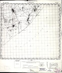
- Subject:
- Topical Subject: Soviet Union, Topical Subject: Maps, and Geographic Subject: Nova Zburyivka
- Publisher:
- Управление военных топографов РККА
- Language:
- Russian
- Identifier:
- VAC9619-001970
- Genre:
- Military Maps and Topographic Maps
- Geographic Location:
- Coordinates: 46, 32, 46.6667, 33
- Related URL:
- Catalog URL: https://iucat.iu.edu/catalog/5020129 and Download GeoTIFF: https://drive.google.com/open?id=1-thPgqtG-jaqsZByPZShVF3bGaZRmnrU
- Abstract:
- Modern area represented: Nova Zburyivka, Kherson oblast, Ukraine
- Call Number:
- G7000 s100 .S7 sheet L-36-53
- Copyright Holder:
- No Copyright - United States
- Country:
- СССР (USSR)
- Physical Description:
- Scale: 1:100,000
- Persistent URL:
- http://purl.dlib.indiana.edu/iudl/images/VAC9619/VAC9619-001970
- Provenance:
- CIA Map Library
-

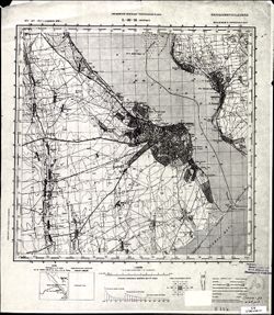
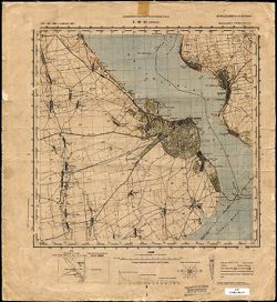
- Description:
- 1928
- Subject:
- Topical Subject: Soviet Union, Topical Subject: Maps, and Geographic Subject: Odessa
- Publisher:
- Управление военных топографов РККА
- Language:
- Russian
- Date Created:
- 1930
- Identifier:
- VAC9619-001904
- Genre:
- Military Maps and Topographic Maps
- Geographic Location:
- Coordinates: 46.3333, 30.5, 46.6667, 31
- Related URL:
- Catalog URL: https://iucat.iu.edu/catalog/5020129 and Download GeoTIFF: https://drive.google.com/file/d/1Uypmq-K0WjG7stanIyRYhQNFVayWvM9b/view?usp=sharing
- Abstract:
- Modern area represented: Odessa, Odessa oblast, Ukraine
- Call Number:
- G7000 s100 .S7 sheet L-36-50
- Caption:
- Не подлежит оглашению
- City:
- Одесса (Odessa)
- Copyright Holder:
- No Copyright - United States
- Country:
- СССР (USSR)
- State/Province:
- Украинская ССР (Ukrainian Soviet Socialist Republic) and Одесская область (Odessa oblast)
- Physical Description:
- Scale: 1:100,000
- Persistent URL:
- http://purl.dlib.indiana.edu/iudl/images/VAC9619/VAC9619-001904
- Provenance:
- DMA Topographic Center, Army Map Service Library, OMAHA
-
- Description:
- 1929
- Subject:
- Topical Subject: Maps, Topical Subject: Soviet Union, and Geographic Subject: Ivanivka
- Publisher:
- Управление военных топографов РККА
- Language:
- Russian
- Identifier:
- VAC9619-000110
- Genre:
- Topographic Maps and Military Maps
- Geographic Location:
- Coordinates: 46.8333, 30.25, 47, 30.5
- Related URL:
- Download GeoTIFF: https://drive.google.com/open?id=1sNqiezUwVXZA-XqdRV2ZAzgcoG64w9q6 and Catalog URL: http://iucat.iu.edu/catalog/5020131
- Abstract:
- Modern area represented: Ivanivka, Odessa oblast, Ukraine
- Call Number:
- G7000 s50 .S68 sheet L-36-37-B
- Caption:
- Не подлежит оглашению
- City:
- Яновка (Yanovka)
- Copyright Holder:
- No Copyright - United States
- Country:
- СССР (USSR)
- State/Province:
- Одесская область (Odessa oblast) and Украинская ССР (Ukrainian Soviet Socialist Republic)
- Physical Description:
- Scale: 1:50,000
- Persistent URL:
- http://purl.dlib.indiana.edu/iudl/images/VAC9619/VAC9619-000110
- Provenance:
- DMA Topographic Center, Army Map Service Library, OMAHA, Library of Congress Geography & Map Division
-
- Subject:
- Geographic Subject: Mykolayiv, Topical Subject: Soviet Union, and Topical Subject: Maps
- Publisher:
- Управление военных топографов РККА
- Language:
- Russian
- Identifier:
- VAC9619-001969
- Genre:
- Military Maps and Topographic Maps
- Geographic Location:
- Coordinates: 46.6667, 32, 47.3333, 33
- Related URL:
- Catalog URL: https://iucat.iu.edu/catalog/5020129 and Download GeoTIFF: https://drive.google.com/open?id=1_-3xSjRAfYvs-ydj1w3WLbf9VqAmWehB
- Abstract:
- Modern area represented: Mykolayiv, Mykolayiv oblast, Ukraine
- Call Number:
- G7000 s100 .S7 sheet L-36-29
- Copyright Holder:
- No Copyright - United States
- Country:
- СССР (USSR)
- Physical Description:
- Scale: 1:100,000
- Persistent URL:
- http://purl.dlib.indiana.edu/iudl/images/VAC9619/VAC9619-001969
- Provenance:
- CIA Map Library
-
- Description:
- 1929
- Subject:
- Topical Subject: Soviet Union, Geographic Subject: Berezivka, and Topical Subject: Maps
- Publisher:
- Управление военных топографов РККА
- Language:
- Russian
- Date Created:
- 1930
- Identifier:
- VAC9619-001874
- Genre:
- Topographic Maps and Military Maps
- Geographic Location:
- Coordinates: 47, 30.5, 47.3333, 31
- Related URL:
- Catalog URL: https://iucat.iu.edu/catalog/5020129 and Download GeoTIFF: https://drive.google.com/open?id=1tjPZZpubs6FnCKvxrgC4b9CZsV8yHLrS
- Abstract:
- Modern area represented: Berezivka, Odessa oblast, Ukraine
- Call Number:
- G7000 s100 .S7 sheet L-36-26
- Caption:
- Не подлежит оглашению
- City:
- Березовка (Berezivka)
- Copyright Holder:
- No Copyright - United States
- Country:
- СССР (USSR)
- State/Province:
- Одесская область (Odessa oblast) and Украинская ССР (Ukrainian Soviet Socialist Republic)
- Physical Description:
- Scale: 1:100,000
- Persistent URL:
- http://purl.dlib.indiana.edu/iudl/images/VAC9619/VAC9619-001874
- Provenance:
- DMA Topographic Center, Army Map Service Library, Library of Congress Geography & Map Division
-

- Description:
- 1929
- Subject:
- Geographic Subject: Petrovirivka, Topical Subject: Maps, and Topical Subject: Soviet Union
- Publisher:
- Управление военных топографов РККА
- Language:
- Russian
- Date Created:
- 1933
- Identifier:
- VAC9619-001872
- Genre:
- Military Maps and Topographic Maps
- Geographic Location:
- Coordinates: 47, 30, 47.3333, 30.5
- Related URL:
- Catalog URL: https://iucat.iu.edu/catalog/5020129 and Download GeoTIFF: https://drive.google.com/open?id=1Yp0PmoQ_FhFSY9xYe9Mdj5WFZQ1lZ9L8
- Abstract:
- Modern area represented: Petrovirivka, Odessa oblast, Ukraine
- Call Number:
- G7000 s100 .S7 sheet L-36-25
- Caption:
- Не подлежит оглашению
- City:
- Жовтнево (Zhovtnevo)
- Copyright Holder:
- No Copyright - United States
- Country:
- СССР (USSR)
- State/Province:
- Одесская область (Odessa oblast) and Украинская ССР (Ukrainian Soviet Socialist Republic)
- Physical Description:
- Scale: 1:100,000
- Persistent URL:
- http://purl.dlib.indiana.edu/iudl/images/VAC9619/VAC9619-001872
- Provenance:
- DMA Topographic Center, Atlasblatt, Library of Congress Geography & Map Division, Army Map Service Library
-
- Description:
- 1894
- Subject:
- Geographic Subject: Târgu Frumos, Topical Subject: Maps, and Topical Subject: Soviet Union
- Publisher:
- Управление военных топографов РККА
- Language:
- Russian
- Date Created:
- 1895
- Identifier:
- VAC9619-001513
- Genre:
- Topographic Maps and Military Maps
- Geographic Location:
- Coordinates: 47, 27, 47.3333, 27.5
- Related URL:
- Catalog URL: https://iucat.iu.edu/catalog/5020129 and Download GeoTIFF: https://drive.google.com/open?id=1LC0U4QZ-lg_KQMIgNHXryuR7uKbf-_vN
- Abstract:
- Modern area represented: Târgu Frumos, Iași county, Romania
- Call Number:
- G7000 s100 .S7 sheet L-35-31
- City:
- Тыргул Фрумос (Târgu Frumos)
- Copyright Holder:
- No Copyright - United States
- Country:
- Румыния (Romania)
- Physical Description:
- Scale: 1:100,000
- Persistent URL:
- http://purl.dlib.indiana.edu/iudl/images/VAC9619/VAC9619-001513
- Provenance:
- DMA Topographic Center, Army Map Service Library, Library of Congress Geography & Map Division
-
- Description:
- 1914
- Subject:
- Topical Subject: Maps, Topical Subject: Soviet Union, and Geographic Subject: Podilsk
- Publisher:
- Управление военных топографов РККА
- Language:
- Russian
- Date Created:
- 1932
- Identifier:
- VAC9619-001503
- Genre:
- Topographic Maps and Military Maps
- Geographic Location:
- Coordinates: 47.6667, 29.5, 48, 30
- Related URL:
- Catalog URL: https://iucat.iu.edu/catalog/5020129 and Download GeoTIFF: https://drive.google.com/open?id=1GY1T_2cRAKuBJomRz9ZEfhqJTuF0vfG8
- Abstract:
- Modern area represented: Podilsk, Odessa oblast, Ukraine
- Call Number:
- G7000 s100 .S7 sheet L-35-12
- Caption:
- Не подлежит оглашению
- City:
- Котовск (Kotovsk)
- Copyright Holder:
- No Copyright - United States
- Country:
- СССР (USSR)
- State/Province:
- Одесская область (Odessa oblast), Украинская ССР (Ukrainian Soviet Socialist Republic), and Молдавская АССР (Moldavian Autonomous Soviet Socialist Republic)
- Physical Description:
- Scale: 1:100,000
- Persistent URL:
- http://purl.dlib.indiana.edu/iudl/images/VAC9619/VAC9619-001503
- Provenance:
- CIA Map Library, Auswärtiges Amt. Geographischer Dienst
