
Search Constraints
You searched for:
Subject
Topical Subject: Caves
Remove constraint Subject: Topical Subject: Caves
1 - 7 of 7
Search Results
-
- Subject:
- Topical Subject: Caves, Topical Subject: IGS Annual Reports, Topical Subject: Speleothems, and Geographic Subject: Wyandotte Cave (Ind.)
- Creator:
- Collett, John, 1828-1899
- Publisher:
- Indiana. Geological Survey
- Date Created:
- 1879
- Identifier:
- VAC3073-M-01552
- Genre:
- Drawings, Pictorial works, Tables (Data), and Thematic maps
- Geographic Location:
- Coordinates: W0861746 W0861746 N0381341 N0381341
- Related URL:
- Catalog URL: https://iucat.iu.edu/catalog/18372653
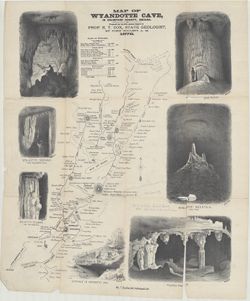
- Abstract:
- Prepared for the 10th Annual Report of Prof. E. T. Cox, State Geologist, by John Collett, A. M. Relief shown by hachures. Includes sketches of some cave feat...
- Call Number:
- G4093.C7C23 1878 .C6
- Caption:
- Imprint: [Indianapolis] : [Indianapolis Journal Company, State printers], [1879] and Imprint: [Indianapolis] : [Geological Survey of Indiana], [1879]
- Physical Description:
- Dimensions: on sheet 54 x 46 cm and Scale: Approximately 1:11,000
- Alternate Identifier:
- Alternate ID: 390723IP and Title Control Number: a18372653
- Persistent URL:
- https://purl.dlib.indiana.edu/iudl/images/VAC3073/VAC3073-M-01552
- Provenance:
- 8th, 9th, and 10th Annual Reports (1876, 1877, 1878) / Indiana. Geological Survey.
-
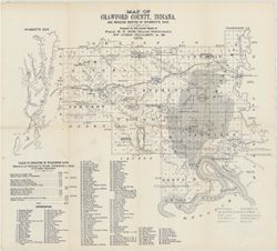
- Subject:
- Topical Subject: IGS Annual Reports, Topical Subject: Coal mines and mining, Geographic Subject: Crawford County (Ind.), Geographic Subject: Wyandotte Cave (...
- Creator:
- Collett, John, 1828-1899
- Publisher:
- Indiana. Geological Survey
- Date Created:
- 1879
- Identifier:
- VAC3073-M-01546
- Genre:
- Thematic maps
- Geographic Location:
- Coordinates: W0863746 W0861445 N0382324 N0380600
- Related URL:
- Catalog URL: https://iucat.iu.edu/catalog/18349479
- Abstract:
- Prepared for 10th annual report of Prof. E.T. Cox, State Geologist by John Collett, 1878. Relief shown by hachures. Shows cities and towns, railroads, cavern...
- Call Number:
- G4093.C7C5 1878 .C6
- Caption:
- Imprint: [Indianapolis] : [Geological Survey of Indiana], [1879] and Imprint: [Indianapolis] : [Indianapolis Journal Company, State printers], [1879]
- Physical Description:
- Scale: Approximately 1:125,000 and Dimensions: on sheet 39 x 44 cm
- Alternate Identifier:
- Title Control Number: a18349479 and Alternate ID: 390723IP
- Persistent URL:
- https://purl.dlib.indiana.edu/iudl/images/VAC3073/VAC3073-M-01546
- Provenance:
- 8th, 9th, and 10th Annual Reports (1876, 1877, 1878) / Indiana. Geological Survey.
-
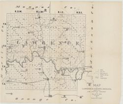
- Subject:
- Topical Subject: Mines and mineral resources, Topical Subject: Caves, Geographic Subject: Lawrence County (Ind.), Topical Subject: Geology, and Topical Subje...
- Creator:
- Collett, John, 1828-1899 and Cox, E. T. (Edward Travers), 1821-1907
- Publisher:
- Indiana. Geological Survey
- Date Created:
- 1874
- Identifier:
- VAC3073-M-01544
- Genre:
- Thematic maps
- Geographic Location:
- Coordinates: W0864107 W0861630 N0385938 N0384112
- Related URL:
- Catalog URL: https://iucat.iu.edu/catalog/18318621
- Abstract:
- Prepared for the 5th Annual Report of Prof. E.T. Cox. 1873. Geology by John Collett. Relief shown by hachures. Shows cities and towns, railroads, mills, cave...
- Call Number:
- G4093.L5C5 1873 .C6
- Caption:
- Imprint: [Indianapolis] : [Sentinel Co., printers], [1874] and Imprint: [Indianapolis] : [Geological Survey of Indiana], [1874]
- Physical Description:
- Scale: Approximately 1:120,000 and Dimensions: on sheet 37 x 44 cm
- Alternate Identifier:
- Title Control Number: a18318621 and Alternate ID: 390723IP
- Persistent URL:
- https://purl.dlib.indiana.edu/iudl/images/VAC3073/VAC3073-M-01544
- Provenance:
- 5th Annual Report (1873) / Indiana. Geological Survey.
-
![Indiana Bloomington quadrangle [1946 reprint with 21 indexed cave locations]](https://iiif.uits.iu.edu/iiif/2/dz011t645%2Ffiles%2Fbb3033b6-3144-4af2-a6c7-a5710771ff06/full/250,/0/default.jpg)
- Subject:
- Geographic Subject: Owen County (Ind.), Geographic Subject: Monroe County (Ind.), Topical Subject: Caves, and Geographic Subject: Greene County (Ind.)
- Creator:
- Griffin, W. H. (William H.), Marshall, R. B. (Robert Bradford), 1867-1949, Sadler, C. L., and Herron, W. H. (William Harrison), 1865-
- Publisher:
- Geological Survey (U.S.)
- Date Created:
- 1946
- Identifier:
- VAC3073-M-01218
- Genre:
- Topographic maps, Quadrangle maps, and 15 minute topographic maps
- Geographic Location:
- Coordinates: W0864500 W0863000 N0391500 N0390000
- Related URL:
- Catalog URL: https://iucat.iu.edu/catalog/18406221
- Abstract:
- R. B. Marshall, chief geographer , W. H. Herron, Geographer in charge , topography by W. H. Griffin and C. L. Sandler , Control by J. R. Ellis and C. H. Semp...
- Call Number:
- G4090 s62 .G4 Bloomington 1910 R1946
- Caption:
- Imprint: [Washington, D.C.] : United States, Department of the Interior, Geological Survey, [1946]
- Physical Description:
- Scale: 1:62,500 and Dimensions: 45 x 42 cm or smaller
- Alternate Identifier:
- Title Control Number: a18406221
- Persistent URL:
- https://purl.dlib.indiana.edu/iudl/images/VAC3073/VAC3073-M-01218
- Provenance:
- Part of Geological Survey (U.S.). Indiana 1:62,500.
-
- Subject:
- Topical Subject: Karst, Topical Subject: Caves, and Geographic Subject: Van Buren (Monroe County, Ind. : Township)
- Creator:
- Powell, Richard L.
- Publisher:
- [publisher not identified]
- Date Created:
- 1968
- Identifier:
- VAC3073-M-00797
- Genre:
- Thematic maps
- Geographic Location:
- Coordinates: W0864058 W0863422 N0390956 N0390443
- Related URL:
- Catalog URL: https://iucat.iu.edu/catalog/5327209
- Abstract:
- Blue line print. _x000d_ "Base prepared from Bloomington, Clear Creek, Stanford and Whitehall topographic quadrangles, U.S.G.S, by the Indiana Geolog...
- Call Number:
- G4094.V28 C23 1968 .P69
- Caption:
- Imprint: [Place of publication not identified] : [publisher not identified], [1968?]
- Physical Description:
- Scale: 1:6,000 and Dimensions: 91 x 92 cm
- Alternate Identifier:
- Title Control Number: a5327209
- Persistent URL:
- https://purl.dlib.indiana.edu/iudl/images/VAC3073/VAC3073-M-00797
-
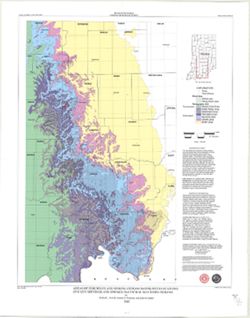
- Subject:
- Topical Subject: Karst, Topical Subject: Sinkholes, Geographic Subject: Indiana, and Topical Subject: Caves
- Creator:
- Powell, Richard L.
- Publisher:
- Indiana. Geological Survey
- Date Created:
- 2002
- Identifier:
- VAC3073-M-00789
- Genre:
- Geological maps
- Geographic Location:
- Coordinates: W0854940 W0845820 N0392712 N0384033
- Related URL:
- Catalog URL: https://iucat.iu.edu/catalog/5325528
- Abstract:
- "This map data was compiled in 1997 from information available at the time, but was unpublished until until 2002, the map does not reflect any changes i...
- Call Number:
- G4091.C28 1997 .P694
- Caption:
- Imprint: [Bloomington, Ind.] : Indiana Geological Survey, 2002.
- Physical Description:
- Dimensions: 54 x 49 cm and Scale: 1:250,000
- Alternate Identifier:
- Title Control Number: a5325528
- Persistent URL:
- https://purl.dlib.indiana.edu/iudl/images/VAC3073/VAC3073-M-00789
-
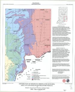
- Subject:
- Topical Subject: Caves, Geographic Subject: Indiana, Topical Subject: Springs, Topical Subject: Sinkholes, and Topical Subject: Karst
- Creator:
- Powell, Richard L.
- Publisher:
- Indiana. Geological Survey
- Date Created:
- 2002
- Identifier:
- VAC3073-M-00135
- Genre:
- Geological maps
- Geographic Location:
- Coordinates: W0870002 W0854608 N0394722 N0375826
- Related URL:
- Catalog URL: https://iucat.iu.edu/catalog/5325676
- Abstract:
- "This map data was compiled in 1997 from information available at the time, but was unpublished until until 2002, the map does not reflect any changes i...
- Call Number:
- G4091.C28 1997 .P69
- Caption:
- Imprint: [Bloomington, Ind.] : Indiana Geological Survey, 2002.
- Physical Description:
- Scale: 1:250,000 and Dimensions: 82 x 42 cm
- Alternate Identifier:
- Title Control Number: a5325676
- Persistent URL:
- https://purl.dlib.indiana.edu/iudl/images/VAC3073/VAC3073-M-00135
