
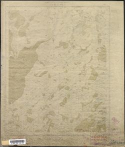
Search Constraints
Search Results
-
- Description:
- 1930
- Subject:
- Topical Subject: Maps, Geographic Subject: Zábřeh, and Topical Subject: Soviet Union
- Publisher:
- Генеральный штаб Красной Армии
- Language:
- Russian
- Date Created:
- 1940
- Identifier:
- VAC9619-002709
- Genre:
- Military Maps and Topographic Maps
- Geographic Location:
- Coordinates: 49.667, 16.5, 50, 17
- Related URL:
- Download GeoTIFF: https://drive.google.com/file/d/1CjzX8Dyvms5C72UF_C4UuUXEF5fI8WuI/view?usp=sharing and Catalog URL: https://iucat.iu.edu/catalog/5020129
- Abstract:
- Modern area represented: Zábřeh, Olomouc region, Czech Republic
- Call Number:
- G7000 s100 .S7 sheet M-33-82
- City:
- Хоенштадт (Hohenstadt)
- Copyright Holder:
- No Copyright - United States
- Country:
- Германия (Germany)
- State/Province:
- Протекторат Богемии и Моравии (Protectorate of Bohemia and Moravia)
- Physical Description:
- Scale: 1:100,000
- Persistent URL:
- http://purl.dlib.indiana.edu/iudl/images/VAC9619/VAC9619-002709
- Provenance:
- DMA Topographic Center, Library of Congress Geography & Map Division, Army Map Service Library, OMAHA
-
- Description:
- 1941
- Subject:
- Topical Subject: Soviet Union, Topical Subject: Maps, and Geographic Subject: Chrudim
- Publisher:
- Генеральный штаб Красной Армии
- Language:
- Russian
- Identifier:
- VAC9619-002707
- Genre:
- Military Maps and Topographic Maps
- Geographic Location:
- Coordinates: 49.667, 15.5, 50, 16
- Related URL:
- Catalog URL: https://iucat.iu.edu/catalog/5020129 and Download GeoTIFF: https://drive.google.com/file/d/1O0DJjm6JDfvtT2QlNV1ejYlQqOy4W6ga/view?usp=sharing
- Abstract:
- Modern area represented: Chrudim, Pardubice region, Czech Republic
- Call Number:
- G7000 s100 .S7 sheet M-33-80
- City:
- Хрудим (Chrudim)
- Copyright Holder:
- No Copyright - United States
- State/Province:
- Протекторат Богемии и Моравии (Protectorate of Bohemia and Moravia)
- Physical Description:
- Scale: 1:100,000
- Persistent URL:
- http://purl.dlib.indiana.edu/iudl/images/VAC9619/VAC9619-002707
- Provenance:
- DMA Topographic Center, Library of Congress Geography & Map Division, Army Map Service Library, OMAHA
-
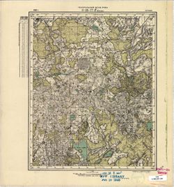
- Description:
- 1869
- Subject:
- Topical Subject: Soviet Union, Topical Subject: Maps, and Geographic Subject: Vysoké Mýto
- Publisher:
- Генеральный штаб Красной Армии
- Language:
- Russian
- Date Created:
- 1941
- Identifier:
- VAC9619-002708
- Genre:
- Military Maps and Topographic Maps
- Geographic Location:
- Coordinates: 49.667, 16, 50, 16.5
- Related URL:
- Download GeoTIFF: https://drive.google.com/file/d/1bxbg0QA-Bm4ku60mqvTMMgwr5Qr1bXw2/view?usp=sharing and Catalog URL: https://iucat.iu.edu/catalog/5020129
- Abstract:
- Modern area represented: Vysoké Mýto, Pardubice region, Czech Republic
- Call Number:
- G7000 s100 .S7 sheet M-33-81
- City:
- Високе Мито (Vysoké Mýto)
- Copyright Holder:
- No Copyright - United States
- Country:
- Германия (Germany)
- State/Province:
- Протекторат Богемии и Моравии (Protectorate of Bohemia and Moravia)
- Physical Description:
- Scale: 1:100,000
- Persistent URL:
- http://purl.dlib.indiana.edu/iudl/images/VAC9619/VAC9619-002708
- Provenance:
- DMA Topographic Center, Army Map Service Library, Library of Congress Geography & Map Division, Auswärtiges Amt. Geographischer Dienst, OMAHA
-
- Description:
- 1912
- Subject:
- Geographic Subject: Lüllemäe, Topical Subject: Maps, and Topical Subject: Soviet Union
- Publisher:
- Генеральный штаб РККА
- Language:
- Russian
- Identifier:
- VAC9619-002705
- Genre:
- Military Maps and Topographic Maps
- Geographic Location:
- Coordinates: 57.667, 26.25, 57.833, 26.5
- Related URL:
- Download GeoTIFF: https://drive.google.com/file/d/1I0hh8ls78tx_LZntneFn7mC5PKtFTZGi/view?usp=sharing and Catalog URL: http://iucat.iu.edu/catalog/5020131
- Abstract:
- Modern area represented: Lüllemäe, Karula vald, Estonia
- Call Number:
- GM G7000 s50 .S68 sheet O-35-77-D
- City:
- Каролен (Karolen)
- Copyright Holder:
- No Copyright - United States
- Country:
- Эстония (Estonia)
- Physical Description:
- Scale: 1:50,000
- Persistent URL:
- http://purl.dlib.indiana.edu/iudl/images/VAC9619/VAC9619-002705
- Provenance:
- M. I. Map Library, Reichsamt für Landesaufnahme, Kartensammlung
-
- Description:
- 1913
- Subject:
- Topical Subject: Maps, Geographic Subject: Antsla, and Topical Subject: Soviet Union
- Publisher:
- Генеральный штаб РККА
- Language:
- Russian
- Identifier:
- VAC9619-002706
- Genre:
- Military Maps and Topographic Maps
- Geographic Location:
- Coordinates: 57.667, 26.5, 57.833, 26.75
- Related URL:
- Download GeoTIFF: https://drive.google.com/file/d/1Lo3MNtysgIEs29nv5842VybcD2wQgKdS/view?usp=sharing and Catalog URL: http://iucat.iu.edu/catalog/5020131
- Abstract:
- Modern area represented: Antsla, Estonia
- Call Number:
- GM G7000 s50 .S68 sheet O-35-78-C
- City:
- Гаука (Gauka)
- Copyright Holder:
- No Copyright - United States
- Country:
- Эстония (Estonia)
- Physical Description:
- Scale: 1:50,000
- Persistent URL:
- http://purl.dlib.indiana.edu/iudl/images/VAC9619/VAC9619-002706
- Provenance:
- M. I. Map Library
-
- Description:
- 1912
- Subject:
- Topical Subject: Maps, Topical Subject: Soviet Union, and Geographic Subject: Tagula
- Publisher:
- Генеральный штаб РККА
- Language:
- Russian
- Identifier:
- VAC9619-002704
- Genre:
- Military Maps and Topographic Maps
- Geographic Location:
- Coordinates: 57.833, 26.25, 58, 26.5
- Related URL:
- Download GeoTIFF: https://drive.google.com/file/d/1aFlAMSYRsLVIV08Eq_btvXIYorT0tYU_/view?usp=sharing and Catalog URL: http://iucat.iu.edu/catalog/5020131
- Abstract:
- Modern area represented: Tagula, Estonia
- Call Number:
- GM G7000 s50 .S68 sheet O-35-77-B
- City:
- Тагула (Tagula)
- Copyright Holder:
- No Copyright - United States
- Country:
- Эстония (Estonia)
- Physical Description:
- Scale: 1:50,000
- Persistent URL:
- http://purl.dlib.indiana.edu/iudl/images/VAC9619/VAC9619-002704
- Provenance:
- CIA Map Library, FEM Austria
-
- Subject:
- Geographic Subject: Priipalu, Topical Subject: Maps, and Topical Subject: Soviet Union
- Publisher:
- Генеральный штаб РККА
- Language:
- Russian
- Identifier:
- VAC9619-002703
- Genre:
- Topographic Maps and Military Maps
- Geographic Location:
- Coordinates: 57.833, 26, 58, 26.25
- Related URL:
- Download GeoTIFF: https://drive.google.com/file/d/1ADEJvKwz69luR84II9placS_C_E0Tjvj/view?usp=sharing and Catalog URL: http://iucat.iu.edu/catalog/5020131
- Abstract:
- Modern area represented: Priipalu, Estonia
- Call Number:
- GM G7000 s50 .S68 sheet O-35-77-A
- City:
- Прийпало (Priipalu)
- Copyright Holder:
- No Copyright - United States
- Country:
- Латвия (Latvia) and Эстония (Estonia)
- Physical Description:
- Scale: 1:50,000
- Persistent URL:
- http://purl.dlib.indiana.edu/iudl/images/VAC9619/VAC9619-002703
- Provenance:
- CIA Map Library
-
- Description:
- 1936
- Subject:
- Topical Subject: Maps, Geographic Subject: Gverzdon', and Topical Subject: Soviet Union
- Publisher:
- Генеральный штаб РККА
- Language:
- Russian
- Identifier:
- VAC9619-002701
- Genre:
- Topographic Maps and Military Maps
- Geographic Location:
- Coordinates: 58, 28.25, 58.167, 28.5
- Related URL:
- Download GeoTIFF: https://drive.google.com/file/d/1CP-E2i8ApPidjwpZuUS6pyjTpk00XKO4/view?usp=sharing and Catalog URL: http://iucat.iu.edu/catalog/5020131
- Abstract:
- Modern area represented: Гверздонь (Gverzdon'), Псковская область (Pskovskaya oblast), Russia
- Call Number:
- GM G7000 s50 .S68 sheet O-35-69-D
- Caption:
- Не подлежит оглашению and Captured map
- City:
- Гверздонь (Gverzdon')
- Copyright Holder:
- No Copyright - United States
- Country:
- СССР (USSR)
- State/Province:
- Ленинградская область (Leningrad oblast) and РСФСР (RSFSR)
- Physical Description:
- Scale: 1:50,000
- Persistent URL:
- http://purl.dlib.indiana.edu/iudl/images/VAC9619/VAC9619-002701
- Provenance:
- Army Map Service Library, OMAHA, Library of Congress Geography & Map Division
-
- Description:
- 1907
- Subject:
- Topical Subject: Maps, Geographic Subject: Matīši, and Topical Subject: Soviet Union
- Publisher:
- Генеральный штаб РККА
- Language:
- Russian
- Identifier:
- VAC9619-002702
- Genre:
- Topographic Maps and Military Maps
- Geographic Location:
- Coordinates: 57.667, 25, 57.833, 25.25
- Related URL:
- Catalog URL: http://iucat.iu.edu/catalog/5020131 and Download GeoTIFF: https://drive.google.com/file/d/12Smxs7znU38TIQM6SbFCUuPZ7FkSPkpG/view?usp=sharing
- Abstract:
- Modern area represented: Matīši, Latvia
- Call Number:
- GM G7000 s50 .S68 sheet O-35-75-C
- Caption:
- Captured map
- City:
- Матиа (Matīši)
- Copyright Holder:
- No Copyright - United States
- Country:
- Латвия (Latvia)
- Physical Description:
- Scale: 1:50,000
- Persistent URL:
- http://purl.dlib.indiana.edu/iudl/images/VAC9619/VAC9619-002702
- Provenance:
- Army Map Service Library, OMAHA, Library of Congress Geography & Map Division
-
- Description:
- 1889
- Subject:
- Topical Subject: Maps, Topical Subject: Soviet Union, and Geographic Subject: Leszno
- Publisher:
- Генеральный штаб Красной Армии
- Language:
- Russian
- Date Created:
- 1940
- Identifier:
- VAC9619-002600
- Genre:
- Topographic Maps and Military Maps
- Geographic Location:
- Coordinates: 51.667, 16.5, 52, 17
- Related URL:
- Download GeoTIFF: https://drive.google.com/file/d/1qcz3KhHAqPFsX6CtdfiqqCVVuuFvfkOb/view?usp=sharing and Catalog URL: https://iucat.iu.edu/catalog/5020129
- Abstract:
- Modern area represented: Leszno, Greater Poland province, Poland
- Call Number:
- G7000 s100 .S7 sheet M-33-10
- City:
- Лисса (Lissa)
- Copyright Holder:
- No Copyright - United States
- Country:
- Германия (Germany)
- Physical Description:
- Scale: 1:100,000
- Persistent URL:
- http://purl.dlib.indiana.edu/iudl/images/VAC9619/VAC9619-002600
- Provenance:
- DMA Topographic Center, Library of Congress G & M Division, Army Map Service Library, OMAHA
