
Search Constraints
You searched for:
State/Province
Украинская ССР (Ukrainian Soviet Socialist Republic)
Remove constraint State/Province: Украинская ССР (Ukrainian Soviet Socialist Republic)
State/Province
Черниговская область (Chernihiv oblast)
Remove constraint State/Province: Черниговская область (Chernihiv oblast)
1 - 33 of 33
Search Results
-

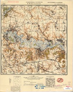
- Description:
- 1938
- Subject:
- Geographic Subject: Novhorod-Siverskyy, Topical Subject: Maps, and Topical Subject: Soviet Union
- Publisher:
- Главное Управление Геодезии и Картографии при СНК СССР
- Language:
- Russian
- Date Created:
- 1941
- Identifier:
- VAC9619-004216
- Genre:
- Military Maps and Topographic Maps
- Geographic Location:
- Coordinates: 52, 33, 52.333, 33.5
- Related URL:
- Download GeoTIFF: https://drive.google.com/file/d/1kaJZgYyUS6Hj_BGfB5UeL-vO4ElM_lO7/view?usp=sharing and Catalog URL: https://iucat.iu.edu/catalog/5020129
- Abstract:
- Modern area represented: Novhorod-Siverskyy, Chernihiv oblast, Ukraine
- Call Number:
- G7000 s100 .S7 sheet N-36-139
- Caption:
- Для служебного пользования
- City:
- Новгород-Северский (Novhorod-Siverskyy)
- Copyright Holder:
- No Copyright - United States
- Country:
- СССР (USSR)
- State/Province:
- Черниговская область (Chernihiv oblast), Украинская ССР (Ukrainian Soviet Socialist Republic), Сумская область (Sumy oblast), РСФСР (RSFSR), and Орловская об...
- Physical Description:
- Scale: 1:100,000
- Persistent URL:
- http://purl.dlib.indiana.edu/iudl/images/VAC9619/VAC9619-004216
- Provenance:
- DMA Topographic Center, Army Map Service Library, OMAHA, Library of Congress Geography & Map Division
-
- Description:
- 1938
- Subject:
- Topical Subject: Maps, Topical Subject: Soviet Union, and Geographic Subject: Semënovka
- Publisher:
- Главное Управление Геодезии и Картографии при СНК СССР
- Language:
- Russian
- Identifier:
- VAC9619-004215
- Genre:
- Military Maps and Topographic Maps
- Geographic Location:
- Coordinates: 52, 32.5, 52.333, 33
- Related URL:
- Download GeoTIFF: https://drive.google.com/file/d/1fV1jj8bxfosoNzFaEIgOetNrQvRV5gum/view?usp=sharing and Catalog URL: https://iucat.iu.edu/catalog/5020129
- Abstract:
- Modern area represented: Semënovka, Russia
- Call Number:
- G7000 s100 .S7 sheet N-36-138
- Caption:
- Для служебного пользования
- City:
- Семеновка (Semënovka)
- Copyright Holder:
- No Copyright - United States
- Country:
- СССР (USSR)
- State/Province:
- Украинская ССР (Ukrainian Soviet Socialist Republic), Орловская область (Oryol oblast), РСФСР (RSFSR), and Черниговская область (Chernihiv oblast)
- Physical Description:
- Scale: 1:100,000
- Persistent URL:
- http://purl.dlib.indiana.edu/iudl/images/VAC9619/VAC9619-004215
- Provenance:
- DMA Topographic Center, Army Map Service Library, OMAHA, Atlasblatt, Library of Congress Geography & Map Division, Geographic Names Branch
-

- Description:
- 1930
- Subject:
- Topical Subject: Soviet Union, Topical Subject: Maps, and Geographic Subject: Novyy Ropsk
- Publisher:
- Генеральный штаб Красной Армии
- Language:
- Russian
- Identifier:
- VAC9619-004214
- Genre:
- Military Maps and Topographic Maps
- Geographic Location:
- Coordinates: 52, 32, 52.333, 32.5
- Related URL:
- Catalog URL: https://iucat.iu.edu/catalog/5020129 and Download GeoTIFF: https://drive.google.com/file/d/1ygDvmMikKrimtW0Ij306dCFLQr69wqQR/view?usp=sharing
- Abstract:
- Modern area represented: Novyy Ropsk, Bryansk oblast, Russia
- Call Number:
- G7000 s100 .S7 sheet N-36-137
- City:
- Новый Ропск (Novyy Ropsk)
- Copyright Holder:
- No Copyright - United States
- Country:
- СССР (USSR)
- State/Province:
- Украинская ССР (Ukrainian Soviet Socialist Republic), РСФСР (RSFSR), Орловская область (Oryol oblast), and Черниговская область (Chernihiv oblast)
- Physical Description:
- Scale: 1:100,000
- Persistent URL:
- http://purl.dlib.indiana.edu/iudl/images/VAC9619/VAC9619-004214
- Provenance:
- DMA Topographic Center, Army Map Service Library, OMAHA, Library of Congress Geography & Map Division
-

- Description:
- 1923
- Subject:
- Topical Subject: Maps, Topical Subject: Soviet Union, and Geographic Subject: Ogorodnya
- Publisher:
- Генеральный штаб Красной Армии
- Language:
- Russian
- Date Created:
- 1941
- Identifier:
- VAC9619-004213
- Genre:
- Topographic Maps and Military Maps
- Geographic Location:
- Coordinates: 52, 31.5, 52.333, 32
- Related URL:
- Download GeoTIFF: https://drive.google.com/file/d/1MuU_oyIyusePmX5IlnPsAE4zUOKWaE3e/view?usp=sharing and Catalog URL: https://iucat.iu.edu/catalog/5020129
- Abstract:
- Modern area represented: Ogorodnya, Homyel voblasc, Belarus
- Call Number:
- G7000 s100 .S7 sheet N-36-136
- City:
- Огородня-Гомельская (Ogorodnya-Gomelskaya)
- Copyright Holder:
- No Copyright - United States
- Country:
- СССР (USSR)
- State/Province:
- Орловская область (Oryol oblast), Украинская ССР (Ukrainian Soviet Socialist Republic), Белорусская ССР (Byelorussian Soviet Socialist Republic), Черниговска...
- Physical Description:
- Scale: 1:100,000
- Persistent URL:
- http://purl.dlib.indiana.edu/iudl/images/VAC9619/VAC9619-004213
- Provenance:
- DMA Topographic Center, Army Map Service Library
-

- Description:
- 1940
- Subject:
- Geographic Subject: Pogar, Topical Subject: Soviet Union, and Topical Subject: Maps
- Publisher:
- Генеральный штаб Красной Армии
- Language:
- Russian
- Date Created:
- 1941
- Identifier:
- VAC9619-004205
- Genre:
- Military Maps and Topographic Maps
- Geographic Location:
- Coordinates: 52.333, 33, 52.667, 33.5
- Related URL:
- Download GeoTIFF: https://drive.google.com/file/d/1-kvEoKectn1YvqFHYD5S7pgdDRdK7MO_/view?usp=sharing and Catalog URL: https://iucat.iu.edu/catalog/5020129
- Abstract:
- Modern area represented: Pogar, bryansk Oblast, Russia
- Call Number:
- G7000 s100 .S7 sheet N-36-127
- City:
- Погар (Pogar)
- Copyright Holder:
- No Copyright - United States
- Country:
- СССР (USSR)
- State/Province:
- Орловская область (Oryol oblast), Украинская ССР (Ukrainian Soviet Socialist Republic), РСФСР (RSFSR), Черниговская область (Chernihiv oblast), and Сумская о...
- Physical Description:
- Scale: 1:100,000
- Persistent URL:
- http://purl.dlib.indiana.edu/iudl/images/VAC9619/VAC9619-004205
- Provenance:
- DMA Topographic Center, Army Map Service Library, OMAHA
-

- Description:
- 1928
- Subject:
- Topical Subject: Soviet Union, Geographic Subject: Yahotyn, and Topical Subject: Maps
- Publisher:
- Генеральный штаб Красной Армии
- Language:
- Russian
- Date Created:
- 1941
- Identifier:
- VAC9619-003293
- Genre:
- Topographic Maps and Military Maps
- Geographic Location:
- Coordinates: 50, 31.5, 50.333, 32
- Related URL:
- Catalog URL: https://iucat.iu.edu/catalog/5020129 and Download GeoTIFF: https://drive.google.com/file/d/1LHmrE7SLHHk3jOpjngs2HIPoYbavjsT9/view?usp=sharing
- Abstract:
- Modern area represented: Yahotyn, Kiev oblast, Ukraine
- Call Number:
- G7000 s100 .S7 sheet M-36-64
- City:
- Яготин (Yahotyn)
- Copyright Holder:
- No Copyright - United States
- Country:
- СССР (USSR)
- State/Province:
- Черниговская область (Chernihiv oblast), Киевская область (Kyiv oblast), Украинская ССР (Ukrainian Soviet Socialist Republic), and Полтавская область (Poltav...
- Physical Description:
- Scale: 1:100,000
- Persistent URL:
- http://purl.dlib.indiana.edu/iudl/images/VAC9619/VAC9619-003293
- Provenance:
- DMA Topographic Center, Army Map Service Library, OMAHA, Library of Congress Geography & Map Division
-
- Description:
- 1931
- Subject:
- Topical Subject: Maps, Topical Subject: Soviet Union, and Geographic Subject: Lokhvytsya
- Publisher:
- Генеральный штаб Красной Армии
- Language:
- Russian
- Date Created:
- 1941
- Identifier:
- VAC9619-003289
- Genre:
- Military Maps and Topographic Maps
- Geographic Location:
- Coordinates: 50.333, 33, 50.667, 33.5
- Related URL:
- Catalog URL: https://iucat.iu.edu/catalog/5020129 and Download GeoTIFF: https://drive.google.com/file/d/1vQ4TVNti6c1j_gpBtUWit3JYm7KLx1sT/view?usp=sharing
- Abstract:
- Modern area represented: Lokhvytsya, Poltava oblast, Ukraine
- Call Number:
- G7000 s100 .S7 sheet M-36-55
- City:
- Лохвица (Lokhvytsya)
- Copyright Holder:
- No Copyright - United States
- Country:
- СССР (USSR)
- State/Province:
- Полтавская область (Poltava oblast), Украинская ССР (Ukrainian Soviet Socialist Republic), Сумская область (Sumy oblast), and Черниговская область (Chernihiv...
- Physical Description:
- Scale: 1:100,000
- Persistent URL:
- http://purl.dlib.indiana.edu/iudl/images/VAC9619/VAC9619-003289
- Provenance:
- DMA Topographic Center, Army Map Service Library, OMAHA, Library of Congress Geography & Map Division
-
- Description:
- 1931
- Subject:
- Topical Subject: Soviet Union, Geographic Subject: Varva, and Topical Subject: Maps
- Publisher:
- Генеральный штаб Красной Армии
- Language:
- Russian
- Date Created:
- 1941
- Identifier:
- VAC9619-003288
- Genre:
- Topographic Maps and Military Maps
- Geographic Location:
- Coordinates: 50.333, 32.5, 50.667, 33
- Related URL:
- Catalog URL: https://iucat.iu.edu/catalog/5020129 and Download GeoTIFF: https://drive.google.com/file/d/1pUKue2pn01xmXAeW2Qd77ZzV9hkBaf5f/view?usp=sharing
- Abstract:
- Modern area represented: Varva, Chernihiv oblast, Ukraine
- Call Number:
- G7000 s100 .S7 sheet M-36-54
- City:
- Варва (Varva)
- Copyright Holder:
- No Copyright - United States
- Country:
- СССР (USSR)
- State/Province:
- Украинская ССР (Ukrainian Soviet Socialist Republic), Черниговская область (Chernihiv oblast), and Полтавская область (Poltava oblast)
- Physical Description:
- Scale: 1:100,000
- Persistent URL:
- http://purl.dlib.indiana.edu/iudl/images/VAC9619/VAC9619-003288
- Provenance:
- DMA Topographic Center, Army Map Service Library, OMAHA, Library of Congress Geography & Map Division
-
- Description:
- 1931
- Subject:
- Topical Subject: Soviet Union, Geographic Subject: Romny, and Topical Subject: Maps
- Publisher:
- Генеральный штаб Красной Армии
- Language:
- Russian
- Date Created:
- 1941
- Identifier:
- VAC9619-003285
- Genre:
- Military Maps and Topographic Maps
- Geographic Location:
- Coordinates: 50.667, 33, 51, 33.5
- Related URL:
- Download GeoTIFF: https://drive.google.com/file/d/1FW6CWXi29eADIbfLr_jJTfo851suSqQs/view?usp=sharing and Catalog URL: https://iucat.iu.edu/catalog/5020129
- Abstract:
- Modern area represented: Romny, Sumy oblast, Ukraine
- Call Number:
- G7000 s100 .S7 sheet M-36-43
- City:
- Ромны (Romny)
- Copyright Holder:
- No Copyright - United States
- Country:
- СССР (USSR)
- State/Province:
- Черниговская область (Chernihiv oblast), Сумская область (Sumy oblast), and Украинская ССР (Ukrainian Soviet Socialist Republic)
- Physical Description:
- Scale: 1:100,000
- Persistent URL:
- http://purl.dlib.indiana.edu/iudl/images/VAC9619/VAC9619-003285
- Provenance:
- DMA Topographic Center, Army Map Service Library, OMAHA, Library of Congress Geography & Map Division
-

- Description:
- 1931
- Subject:
- Geographic Subject: Ivanitsa, Topical Subject: Soviet Union, and Topical Subject: Maps
- Publisher:
- Генеральный штаб Красной Армии
- Language:
- Russian
- Date Created:
- 1941
- Identifier:
- VAC9619-003284
- Genre:
- Topographic Maps and Military Maps
- Geographic Location:
- Coordinates: 50.667, 32.5, 51, 33
- Related URL:
- Download GeoTIFF: https://drive.google.com/file/d/1gP3A56Jcp0_cOWputIwelkHJ5U_WsUb0/view?usp=sharing and Catalog URL: https://iucat.iu.edu/catalog/5020129
- Abstract:
- Modern area represented: Ivanitsa, Chernihiv oblast, Ukraine
- Call Number:
- G7000 s100 .S7 sheet M-36-42
- City:
- Иваница (Ivanitsa)
- Copyright Holder:
- No Copyright - United States
- Country:
- СССР (USSR)
- State/Province:
- Сумская область (Sumy oblast), Украинская ССР (Ukrainian Soviet Socialist Republic), and Черниговская область (Chernihiv oblast)
- Physical Description:
- Scale: 1:100,000
- Persistent URL:
- http://purl.dlib.indiana.edu/iudl/images/VAC9619/VAC9619-003284
- Provenance:
- DMA Topographic Center, Army Map Service Library, OMAHA, Library of Congress Geography & Map Division
-
- Description:
- 1928
- Subject:
- Topical Subject: Maps, Topical Subject: Soviet Union, and Geographic Subject: Ichnya
- Publisher:
- Генеральный штаб Красной Армии
- Language:
- Russian
- Date Created:
- 1941
- Identifier:
- VAC9619-003283
- Genre:
- Topographic Maps and Military Maps
- Geographic Location:
- Coordinates: 50.667, 32, 51, 32.5
- Related URL:
- Catalog URL: https://iucat.iu.edu/catalog/5020129 and Download GeoTIFF: https://drive.google.com/file/d/1Ac29ODFpGjgWmzV6weqS5xHNFSvVVWYm/view?usp=sharing
- Abstract:
- Modern area represented: Ichnya, Chernihiv oblast, Ukraine
- Call Number:
- G7000 s100 .S7 sheet M-36-41
- City:
- Ичня (Ichnya)
- Copyright Holder:
- No Copyright - United States
- Country:
- СССР (USSR)
- State/Province:
- Украинская ССР (Ukrainian Soviet Socialist Republic) and Черниговская область (Chernihiv oblast)
- Physical Description:
- Scale: 1:100,000
- Persistent URL:
- http://purl.dlib.indiana.edu/iudl/images/VAC9619/VAC9619-003283
- Provenance:
- DMA Topographic Center, Army Map Service Library
-
- Description:
- 1928
- Subject:
- Topical Subject: Maps, Geographic Subject: Nosivka, and Topical Subject: Soviet Union
- Publisher:
- Генеральный штаб Красной Армии
- Language:
- Russian
- Date Created:
- 1941
- Identifier:
- VAC9619-003282
- Genre:
- Topographic Maps and Military Maps
- Geographic Location:
- Coordinates: 50.667, 31.5, 51, 32
- Related URL:
- Download GeoTIFF: https://drive.google.com/file/d/10MygBybi2xuqc14bonfjkweaMqUlhu2F/view?usp=sharing and Catalog URL: https://iucat.iu.edu/catalog/5020129
- Abstract:
- Modern area represented: Nosivka, Chernihiv oblast, Ukraine
- Call Number:
- G7000 s100 .S7 sheet M-36-40
- City:
- Носовка (Nosivka)
- Copyright Holder:
- No Copyright - United States
- Country:
- СССР (USSR)
- State/Province:
- Черниговская область (Chernihiv oblast) and Украинская ССР (Ukrainian Soviet Socialist Republic)
- Physical Description:
- Scale: 1:100,000
- Persistent URL:
- http://purl.dlib.indiana.edu/iudl/images/VAC9619/VAC9619-003282
- Provenance:
- DMA Topographic Center, Army Map Service Library, Geographic Names Branch
-
- Description:
- 1928
- Subject:
- Geographic Subject: Kozelets, Topical Subject: Soviet Union, and Topical Subject: Maps
- Publisher:
- Генеральный штаб Красной Армии
- Language:
- Russian
- Date Created:
- 1941
- Identifier:
- VAC9619-003281
- Genre:
- Topographic Maps and Military Maps
- Geographic Location:
- Coordinates: 50.667, 31, 51, 31.5
- Related URL:
- Catalog URL: https://iucat.iu.edu/catalog/5020129 and Download GeoTIFF: https://drive.google.com/file/d/1bdLuMKmcu_wAyoVyB1BdVrrGMEDr-I9g/view?usp=sharing
- Abstract:
- Modern area represented: Kozelets, Chernihiv oblast, Ukraine
- Call Number:
- G7000 s100 .S7 sheet M-36-39
- Caption:
- Для служебного пользования
- City:
- Козелец (Kozelets)
- Copyright Holder:
- No Copyright - United States
- Country:
- СССР (USSR)
- State/Province:
- Черниговская область (Chernihiv oblast) and Украинская ССР (Ukrainian Soviet Socialist Republic)
- Physical Description:
- Scale: 1:100,000
- Persistent URL:
- http://purl.dlib.indiana.edu/iudl/images/VAC9619/VAC9619-003281
- Provenance:
- DMA Topographic Center, Army Map Service Library, OMAHA, Atlasblatt, Library of Congress Geography & Map Division
-
- Description:
- 1931
- Subject:
- Geographic Subject: Konotop, Topical Subject: Soviet Union, and Topical Subject: Maps
- Publisher:
- Генеральный штаб Красной Армии
- Language:
- Russian
- Date Created:
- 1941
- Identifier:
- VAC9619-003275
- Genre:
- Military Maps and Topographic Maps
- Geographic Location:
- Coordinates: 51, 33, 51.333, 33.5
- Related URL:
- Catalog URL: https://iucat.iu.edu/catalog/5020129 and Download GeoTIFF: https://drive.google.com/file/d/1r8ohms6j7-oroetF4RNsMqiHtG6Ch7pC/view?usp=sharing
- Abstract:
- Modern area represented: Konotop, Sumy oblast, Ukraine
- Call Number:
- G7000 s100 .S7 sheet M-36-31
- City:
- Конотоп (Konotop)
- Copyright Holder:
- No Copyright - United States
- Country:
- СССР (USSR)
- State/Province:
- Сумская область (Sumy oblast), Украинская ССР (Ukrainian Soviet Socialist Republic), and Черниговская область (Chernihiv oblast)
- Physical Description:
- Scale: 1:100,000
- Persistent URL:
- http://purl.dlib.indiana.edu/iudl/images/VAC9619/VAC9619-003275
- Provenance:
- DMA Topographic Center, Auswärtiges Amt. Geographischer Dienst, Army Map Service Library
-
- Description:
- 1929
- Subject:
- Topical Subject: Maps, Geographic Subject: Bakhmach, and Topical Subject: Soviet Union
- Publisher:
- Генеральный штаб Красной Армии
- Language:
- Russian
- Date Created:
- 1941
- Identifier:
- VAC9619-003274
- Genre:
- Topographic Maps and Military Maps
- Geographic Location:
- Coordinates: 51, 32.5, 51.333, 33
- Related URL:
- Download GeoTIFF: https://drive.google.com/file/d/1umoYAQWJnajCte-zrkNIKjSDraw3Xa0p/view?usp=sharing and Catalog URL: https://iucat.iu.edu/catalog/5020129
- Abstract:
- Modern area represented: Bakhmach, Chernihiv oblast, Ukraine
- Call Number:
- G7000 s100 .S7 sheet M-36-30
- City:
- Бахмач (Bakhmach)
- Copyright Holder:
- No Copyright - United States
- Country:
- СССР (USSR)
- State/Province:
- Украинская ССР (Ukrainian Soviet Socialist Republic) and Черниговская область (Chernihiv oblast)
- Physical Description:
- Scale: 1:100,000
- Persistent URL:
- http://purl.dlib.indiana.edu/iudl/images/VAC9619/VAC9619-003274
- Provenance:
- DMA Topographic Center, Army Map Service Library
-
- Description:
- 1928
- Subject:
- Geographic Subject: Borzna, Topical Subject: Maps, and Topical Subject: Soviet Union
- Publisher:
- Генеральный штаб Красной Армии
- Language:
- Russian
- Date Created:
- 1941
- Identifier:
- VAC9619-003273
- Genre:
- Military Maps and Topographic Maps
- Geographic Location:
- Coordinates: 51, 32, 51.333, 32.5
- Related URL:
- Download GeoTIFF: https://drive.google.com/file/d/13YqIm9xaOOdjoo3fARgPJiTT8XKQoa22/view?usp=sharing and Catalog URL: https://iucat.iu.edu/catalog/5020129
- Abstract:
- Modern area represented: Borzna, Chernihiv oblast, Ukraine
- Call Number:
- G7000 s100 .S7 sheet M-36-29
- City:
- Борзна (Borzna)
- Copyright Holder:
- No Copyright - United States
- Country:
- СССР (USSR)
- State/Province:
- Черниговская область (Chernihiv oblast) and Украинская ССР (Ukrainian Soviet Socialist Republic)
- Physical Description:
- Scale: 1:100,000
- Persistent URL:
- http://purl.dlib.indiana.edu/iudl/images/VAC9619/VAC9619-003273
- Provenance:
- DMA Topographic Center, Army Map Service Library, OMAHA, Library of Congress Geography & Map Division
-
- Description:
- 1928
- Subject:
- Geographic Subject: Olishëvka, Topical Subject: Maps, and Topical Subject: Soviet Union
- Publisher:
- Генеральный штаб Красной Армии
- Language:
- Russian
- Date Created:
- 1941
- Identifier:
- VAC9619-003272
- Genre:
- Military Maps and Topographic Maps
- Geographic Location:
- Coordinates: 51, 31, 51.333, 31.5
- Related URL:
- Catalog URL: https://iucat.iu.edu/catalog/5020129 and Download GeoTIFF: https://drive.google.com/file/d/1gDn0qrpzVUse2_HrwBAGXhhsuSxCOu6I/view?usp=sharing
- Abstract:
- Modern area represented: Olishëvka, Chernihiv oblast, Ukraine
- Call Number:
- G7000 s100 .S7 sheet M-36-27
- Caption:
- Для служебного пользования
- City:
- Олишевка (Olishëvka)
- Copyright Holder:
- No Copyright - United States
- Country:
- СССР (USSR)
- State/Province:
- Черниговская область (Chernihiv oblast) and Украинская ССР (Ukrainian Soviet Socialist Republic)
- Physical Description:
- Scale: 1:100,000
- Persistent URL:
- http://purl.dlib.indiana.edu/iudl/images/VAC9619/VAC9619-003272
- Provenance:
- DMA Topographic Center, Army Map Service Library
-
- Description:
- 1924
- Subject:
- Topical Subject: Maps, Topical Subject: Soviet Union, and Geographic Subject: Sorokoshichi
- Publisher:
- Генеральный штаб Красной Армии
- Language:
- Russian
- Date Created:
- 1941
- Identifier:
- VAC9619-003271
- Genre:
- Topographic Maps and Military Maps
- Geographic Location:
- Coordinates: 51, 30.5, 51.333, 31
- Related URL:
- Download GeoTIFF: https://drive.google.com/file/d/1KxaQ7Xoh_2tWdxEvMRNheFDM8vAmtddO/view?usp=sharing and Catalog URL: https://iucat.iu.edu/catalog/5020129
- Abstract:
- Modern area represented: Sorokoshichi, Chernihiv oblast, Ukraine
- Call Number:
- G7000 s100 .S7 sheet M-36-26
- Caption:
- Для служебного пользования
- City:
- Сорокошичи (Sorokoshichi)
- Copyright Holder:
- No Copyright - United States
- Country:
- СССР (USSR)
- State/Province:
- Полесская область (Polesia oblast), Белорусская ССР (Byelorussian Soviet Socialist Republic), Украинская ССР (Ukrainian Soviet Socialist Republic), and Черни...
- Physical Description:
- Scale: 1:100,000
- Persistent URL:
- http://purl.dlib.indiana.edu/iudl/images/VAC9619/VAC9619-003271
- Provenance:
- DMA Topographic Center, Army Map Service Library
-
- Description:
- 1929
- Subject:
- Topical Subject: Maps, Topical Subject: Soviet Union, and Geographic Subject: Chornobyl
- Publisher:
- Генеральный штаб РККА
- Language:
- Russian
- Date Created:
- 1932
- Identifier:
- VAC9619-003270
- Genre:
- Military Maps and Topographic Maps
- Geographic Location:
- Coordinates: 51, 30, 51.333, 30.5
- Related URL:
- Catalog URL: https://iucat.iu.edu/catalog/5020129 and Download GeoTIFF: https://drive.google.com/file/d/1yIQsvVJLXuA-9oO1lvbl2PPyyofDIkua/view?usp=sharing
- Abstract:
- Modern area represented: Chornobyl, Kiev oblast, Ukraine
- Call Number:
- G7000 s100 .S7 sheet M-36-25
- Caption:
- Не подлежит оглашению
- City:
- Чернобыль (Chornobyl)
- Copyright Holder:
- No Copyright - United States
- Country:
- СССР (USSR)
- State/Province:
- Украинская ССР (Ukrainian Soviet Socialist Republic), Черниговская область (Chernihiv oblast), Полесская область (Polesia oblast), Белорусская ССР (Byeloruss...
- Physical Description:
- Scale: 1:100,000
- Persistent URL:
- http://purl.dlib.indiana.edu/iudl/images/VAC9619/VAC9619-003270
- Provenance:
- DMA Topographic Center, Army Map Service Library, OMAHA, Library of Congress Geography & Map Division
-
- Description:
- 1928
- Subject:
- Geographic Subject: Mena, Topical Subject: Maps, and Topical Subject: Soviet Union
- Publisher:
- Генеральный штаб Красной Армии
- Language:
- Russian
- Date Created:
- 1941
- Identifier:
- VAC9619-003267
- Genre:
- Topographic Maps and Military Maps
- Geographic Location:
- Coordinates: 51.333, 32, 51.667, 32.5
- Related URL:
- Download GeoTIFF: https://drive.google.com/file/d/1phkCWfZcewvaUbgcNfhmuGCrKQ8b1AQV/view?usp=sharing and Catalog URL: https://iucat.iu.edu/catalog/5020129
- Abstract:
- Modern area represented: Mena, Chernihiv oblast, Ukraine
- Call Number:
- G7000 s100 .S7 sheet M-36-17
- City:
- Мена (Mena)
- Copyright Holder:
- No Copyright - United States
- Country:
- СССР (USSR)
- State/Province:
- Украинская ССР (Ukrainian Soviet Socialist Republic) and Черниговская область (Chernihiv oblast)
- Physical Description:
- Scale: 1:100,000
- Persistent URL:
- http://purl.dlib.indiana.edu/iudl/images/VAC9619/VAC9619-003267
- Provenance:
- Army Map Service Library, Library of Congress G & M Division
-
- Description:
- 1928
- Subject:
- Geographic Subject: Berezna, Topical Subject: Maps, and Topical Subject: Soviet Union
- Publisher:
- Генеральный штаб Красной Армии
- Language:
- Russian
- Date Created:
- 1941
- Identifier:
- VAC9619-003266
- Genre:
- Military Maps and Topographic Maps
- Geographic Location:
- Coordinates: 51.333, 31.5, 51.667, 32
- Related URL:
- Catalog URL: https://iucat.iu.edu/catalog/5020129 and Download GeoTIFF: https://drive.google.com/file/d/1FLzzsNWznVVtjxEYHYJBOazbHuJiKN2f/view?usp=sharing
- Abstract:
- Modern area represented: Berezna, Chernihiv oblast, Ukraine
- Call Number:
- G7000 s100 .S7 sheet M-36-16
- Caption:
- Для служебного пользования
- City:
- Березка (Berezna)
- Copyright Holder:
- No Copyright - United States
- Country:
- СССР (USSR)
- State/Province:
- Украинская ССР (Ukrainian Soviet Socialist Republic) and Черниговская область (Chernihiv oblast)
- Physical Description:
- Scale: 1:100,000
- Persistent URL:
- http://purl.dlib.indiana.edu/iudl/images/VAC9619/VAC9619-003266
- Provenance:
- DMA Topographic Center, Army Map Service Library, OMAHA, Geographic Names Branch
-
- Description:
- 1929
- Subject:
- Topical Subject: Soviet Union, Geographic Subject: Chernihiv, and Topical Subject: Maps
- Publisher:
- Генеральный штаб Красной Армии
- Language:
- Russian
- Date Created:
- 1941
- Identifier:
- VAC9619-003265
- Genre:
- Military Maps and Topographic Maps
- Geographic Location:
- Coordinates: 51.333, 31, 51.667, 31.5
- Related URL:
- Download GeoTIFF: https://drive.google.com/file/d/1BO_uFzmTT3oWS-h7opNBfatVzgRF59jx/view?usp=sharing and Catalog URL: https://iucat.iu.edu/catalog/5020129
- Abstract:
- Modern area represented: Chernihiv, Chernihiv oblast, Ukraine
- Call Number:
- G7000 s100 .S7 sheet M-36-15
- Caption:
- Для служебного пользования
- City:
- Чернигов (Chernihiv)
- Copyright Holder:
- No Copyright - United States
- Country:
- СССР (USSR)
- State/Province:
- Украинская ССР (Ukrainian Soviet Socialist Republic) and Черниговская область (Chernihiv oblast)
- Physical Description:
- Scale: 1:100,000
- Persistent URL:
- http://purl.dlib.indiana.edu/iudl/images/VAC9619/VAC9619-003265
- Provenance:
- DMA Topographic Center, Army Map Service Library, OMAHA, Geographic Names Branch
-
- Description:
- 1939
- Subject:
- Topical Subject: Soviet Union, Topical Subject: Maps, and Geographic Subject: Voronezh
- Publisher:
- Главное управление геодезии и картографии при СНК СССР
- Language:
- Russian
- Date Created:
- 1941
- Identifier:
- VAC9619-003259
- Genre:
- Topographic Maps and Military Maps
- Geographic Location:
- Coordinates: 51.667, 33, 52, 33.5
- Related URL:
- Catalog URL: https://iucat.iu.edu/catalog/5020129 and Download GeoTIFF: https://drive.google.com/file/d/1wkzHfaQ0hqJWsSKZl0nr7EeOORHorj2j/view?usp=sharing
- Abstract:
- Modern area represented: Voronezh, Sumy oblast, Ukraine
- Call Number:
- G7000 s100 .S7 sheet M-36-7
- City:
- Воронеж (Voronezh)
- Copyright Holder:
- No Copyright - United States
- Country:
- СССР (USSR)
- State/Province:
- Украинская ССР (Ukrainian Soviet Socialist Republic), Сумская область (Sumy oblast), and Черниговская область (Chernihiv oblast)
- Physical Description:
- Scale: 1:100,000
- Persistent URL:
- http://purl.dlib.indiana.edu/iudl/images/VAC9619/VAC9619-003259
- Provenance:
- DMA Topographic Center, Army Map Service Library, OMAHA, Atlasblatt
-
- Description:
- 1938
- Subject:
- Topical Subject: Soviet Union, Topical Subject: Maps, and Geographic Subject: Ponornitsa
- Publisher:
- Главное управление геодезии и картографии при СНК СССР
- Language:
- Russian
- Date Created:
- 1941
- Identifier:
- VAC9619-003258
- Genre:
- Topographic Maps and Military Maps
- Geographic Location:
- Coordinates: 51.667, 32.5, 52, 33
- Related URL:
- Download GeoTIFF: https://drive.google.com/file/d/1jcMqiw4doviC_niimFRwaVdI-Gcl6YTQ/view?usp=sharing and Catalog URL: https://iucat.iu.edu/catalog/5020129
- Abstract:
- Modern area represented: Ponornitsa, Chernihiv oblast, Ukraine
- Call Number:
- G7000 s100 .S7 sheet M-36-6
- City:
- Понорница (Ponornitsa)
- Copyright Holder:
- No Copyright - United States
- Country:
- СССР (USSR)
- State/Province:
- Черниговская область (Chernihiv oblast) and Украинская ССР (Ukrainian Soviet Socialist Republic)
- Physical Description:
- Scale: 1:100,000
- Persistent URL:
- http://purl.dlib.indiana.edu/iudl/images/VAC9619/VAC9619-003258
- Provenance:
- DMA Topographic Center, Army Map Service Library, OMAHA, Auswärtiges Amt. Geographischer Dienst
-
- Description:
- 1930
- Subject:
- Topical Subject: Soviet Union, Topical Subject: Maps, and Geographic Subject: Koryukivka
- Publisher:
- Генеральный штаб Красной Армии
- Language:
- Russian
- Date Created:
- 1941
- Identifier:
- VAC9619-003257
- Genre:
- Military Maps and Topographic Maps
- Geographic Location:
- Coordinates: 51.667, 32, 52, 32.5
- Related URL:
- Catalog URL: https://iucat.iu.edu/catalog/5020129 and Download GeoTIFF: https://drive.google.com/file/d/1K3jDpaldJvEyjHgmBYxt-MGTAO3FqX7R/view?usp=sharing
- Abstract:
- Modern area represented: Koryukivka, Chernihiv oblast, Ukraine
- Call Number:
- G7000 s100 .S7 sheet M-36-5
- City:
- Корюковка (Koryukivka)
- Copyright Holder:
- No Copyright - United States
- Country:
- СССР (USSR)
- State/Province:
- Черниговская область (Chernihiv oblast) and Украинская ССР (Ukrainian Soviet Socialist Republic)
- Physical Description:
- Scale: 1:100,000
- Persistent URL:
- http://purl.dlib.indiana.edu/iudl/images/VAC9619/VAC9619-003257
- Provenance:
- DMA Topographic Center, Army Map Service Library, OMAHA, Auswärtiges Amt. Geographischer Dienst
-
- Description:
- 1929
- Subject:
- Geographic Subject: Shchors, Topical Subject: Maps, and Topical Subject: Soviet Union
- Publisher:
- Генеральный штаб Красной Армии
- Language:
- Russian
- Date Created:
- 1941
- Identifier:
- VAC9619-003256
- Genre:
- Topographic Maps and Military Maps
- Geographic Location:
- Coordinates: 51.667, 31.5, 52, 32
- Related URL:
- Catalog URL: https://iucat.iu.edu/catalog/5020129 and Download GeoTIFF: https://drive.google.com/file/d/15aLZJEOvApmI3BbvTqmPUr7GE_MwSXw2/view?usp=sharing
- Abstract:
- Modern area represented: Shchors, Chernihiv oblast, Ukraine
- Call Number:
- G7000 s100 .S7 sheet M-36-4
- City:
- Щорс (Shchors)
- Copyright Holder:
- No Copyright - United States
- Country:
- СССР (USSR)
- State/Province:
- Украинская ССР (Ukrainian Soviet Socialist Republic) and Черниговская область (Chernihiv oblast)
- Physical Description:
- Scale: 1:100,000
- Persistent URL:
- http://purl.dlib.indiana.edu/iudl/images/VAC9619/VAC9619-003256
- Provenance:
- DMA Topographic Center, Army Map Service Library, OMAHA
-
- Description:
- 1928
- Subject:
- Topical Subject: Soviet Union, Topical Subject: Maps, and Geographic Subject: Ripky
- Publisher:
- Генеральный штаб Красной Армии
- Language:
- Russian
- Date Created:
- 1941
- Identifier:
- VAC9619-003255
- Genre:
- Topographic Maps and Military Maps
- Geographic Location:
- Coordinates: 51.667, 31, 52, 31.5
- Related URL:
- Catalog URL: https://iucat.iu.edu/catalog/5020129 and Download GeoTIFF: https://drive.google.com/file/d/10P935UlXmDuSi-VJYY_5DmCufRo7zhm3/view?usp=sharing
- Abstract:
- Modern area represented: Ripky, Chernihiv oblast, Ukraine
- Call Number:
- G7000 s100 .S7 sheet M-36-3
- Caption:
- Для служебного пользования
- City:
- Репки (Ripky)
- Copyright Holder:
- No Copyright - United States
- Country:
- СССР (USSR)
- State/Province:
- Черниговская область (Chernihiv oblast) and Украинская ССР (Ukrainian Soviet Socialist Republic)
- Physical Description:
- Scale: 1:100,000
- Persistent URL:
- http://purl.dlib.indiana.edu/iudl/images/VAC9619/VAC9619-003255
- Provenance:
- DMA Topographic Center, Army Map Service Library, OMAHA, Geographic Names Branch, Atlasblatt
-
- Description:
- 1929
- Subject:
- Topical Subject: Maps, Geographic Subject: Loyew, and Topical Subject: Soviet Union
- Publisher:
- Генеральный штаб Красной Армии
- Language:
- Russian
- Date Created:
- 1941
- Identifier:
- VAC9619-003254
- Genre:
- Topographic Maps and Military Maps
- Geographic Location:
- Coordinates: 51.667, 30.5, 52, 31
- Related URL:
- Catalog URL: https://iucat.iu.edu/catalog/5020129 and Download GeoTIFF: https://drive.google.com/file/d/1pts7bgzSOMFuWGK1hGOGVJSjwKFOPf_0/view?usp=sharing
- Abstract:
- Modern area represented: Loyew, Gomel oblast, Belarus
- Call Number:
- G7000 s100 .S7 sheet M-36-2
- Caption:
- Для служебного пользования
- City:
- Лоев (Loyew)
- Copyright Holder:
- No Copyright - United States
- Country:
- СССР (USSR)
- State/Province:
- Полесская область (Polesia oblast), Гомельская область (Homyel oblast), Украинская ССР (Ukrainian Soviet Socialist Republic), Белорусская ССР (Byelorussian S...
- Physical Description:
- Scale: 1:100,000
- Persistent URL:
- http://purl.dlib.indiana.edu/iudl/images/VAC9619/VAC9619-003254
- Provenance:
- DMA Topographic Center, Army Map Service Library, OMAHA
-
- Description:
- 1931
- Subject:
- Geographic Subject: Romny, Topical Subject: Maps, and Topical Subject: Soviet Union
- Publisher:
- Управление военных топографов РККА
- Language:
- Russian
- Date Created:
- 1937
- Identifier:
- VAC9619-000955
- Genre:
- Military Maps and Topographic Maps
- Geographic Location:
- Coordinates: 50.666667, 33.5, 50.833333, 33.75
- Related URL:
- Download GeoTIFF: https://drive.google.com/open?id=1rnfkKiB1ABVQkI-6sNsQc61EBpY-hEs5 and Catalog URL: http://iucat.iu.edu/catalog/5020131
- Abstract:
- Modern area represented: Romny, Sumy oblast, Ukraine
- Call Number:
- G7000 s50 .S68 sheet M-36-44-C
- Caption:
- Не подлежит оглашению
- City:
- Засулье (Zasulye)
- Copyright Holder:
- No Copyright - United States
- Country:
- СССР (USSR)
- State/Province:
- Украинская ССР (Ukrainian Soviet Socialist Republic) and Черниговская область (Chernihiv oblast)
- Physical Description:
- Scale: 1:50,000
- Persistent URL:
- http://purl.dlib.indiana.edu/iudl/images/VAC9619/VAC9619-000955
- Provenance:
- DMA Topographic Center, Army Map Service Library, Library of Congress Geography & Map Division
-
- Description:
- 1931
- Subject:
- Topical Subject: Soviet Union, Geographic Subject: Terny, and Topical Subject: Maps
- Publisher:
- Управление военных топографов РККА
- Language:
- Russian
- Identifier:
- VAC9619-000954
- Genre:
- Topographic Maps and Military Maps
- Geographic Location:
- Coordinates: 50.83333, 33.75, 51.0, 34.0
- Related URL:
- Catalog URL: http://iucat.iu.edu/catalog/5020131 and Download GeoTIFF: https://drive.google.com/open?id=13OXcKvBOdgaCwqxa6E9aF935ZUS4bLKc
- Abstract:
- Modern area represented: Terny, Sumy oblast, Ukraine
- Call Number:
- G7000 s50 .S68 sheet M-36-44-B
- Caption:
- Не подлежит оглашению,Captured map
- City:
- Терны (Terny)
- Copyright Holder:
- No Copyright - United States
- Country:
- СССР (USSR)
- State/Province:
- Украинская ССР (Ukrainian Soviet Socialist Republic), Черниговская область (Chernihiv oblast), and Харьковская область (Kharkiv oblast)
- Physical Description:
- Scale: 1:50,000
- Persistent URL:
- http://purl.dlib.indiana.edu/iudl/images/VAC9619/VAC9619-000954
- Provenance:
- DMA Topographic Center, Army Map Service Library, OMAHA, Library of Congress Geography & Map Division
-
- Description:
- 1931
- Subject:
- Geographic Subject: Smile, Topical Subject: Soviet Union, and Topical Subject: Maps
- Publisher:
- Управление военных топографов РККА
- Language:
- Russian
- Identifier:
- VAC9619-000953
- Genre:
- Military Maps and Topographic Maps
- Geographic Location:
- Coordinates: 50.833333, 33.5, 51.0, 33.75
- Related URL:
- Download GeoTIFF: https://drive.google.com/open?id=1XoB9WQl3FPMl5P3yWDsRRibyqOqwwoKT and Catalog URL: http://iucat.iu.edu/catalog/5020131
- Abstract:
- Modern area represented: Smile, Sumy oblast, Ukraine
- Call Number:
- G7000 s50 .S68 sheet M-36-44-A
- Caption:
- Не подлежит оглашению
- City:
- Смиле (Smile)
- Copyright Holder:
- No Copyright - United States
- Country:
- СССР (USSR)
- State/Province:
- Черниговская область (Chernihiv oblast) and Украинская ССР (Ukrainian Soviet Socialist Republic)
- Physical Description:
- Scale: 1:50,000
- Persistent URL:
- http://purl.dlib.indiana.edu/iudl/images/VAC9619/VAC9619-000953
- Provenance:
- DMA Topographic Center, Army Map Service Library, OMAHA, Library of Congress Geography & Map Division
-
- Description:
- 1931
- Subject:
- Topical Subject: Maps, Topical Subject: Soviet Union, and Geographic Subject: Krasnyi Kolyadyn
- Publisher:
- Управление военных топографов РККА
- Language:
- Russian
- Identifier:
- VAC9619-000952
- Genre:
- Topographic Maps and Military Maps
- Geographic Location:
- Coordinates: 50.83333, 33.0, 51.0, 33.25
- Related URL:
- Download GeoTIFF: https://drive.google.com/open?id=187ehuuXYbkhUIR_mdoQdc0mgHkdXNwe5 and Catalog URL: http://iucat.iu.edu/catalog/5020131
- Abstract:
- Modern area represented: Krasnyi Kolyadyn, Chernihiv oblast, Ukraine
- Call Number:
- G7000 s50 .S68 sheet M-36-43-A
- Caption:
- Не подлежит оглашению
- City:
- Красный Колядин (Krasnyi Kolyadyn)
- Copyright Holder:
- No Copyright - United States
- Country:
- СССР (USSR)
- State/Province:
- Украинская ССР (Ukrainian Soviet Socialist Republic) and Черниговская область (Chernihiv oblast)
- Physical Description:
- Scale: 1:50,000
- Persistent URL:
- http://purl.dlib.indiana.edu/iudl/images/VAC9619/VAC9619-000952
- Provenance:
- M. I. Map Library, G000-30, GS, RA, Atlasblatt, Library of Congress Geography & Map Division
-
- Description:
- 1932
- Subject:
- Topical Subject: Maps, Topical Subject: Soviet Union, and Geographic Subject: Косачiвка (Kosachivka)
- Publisher:
- Управление военных топографов
- Language:
- Russian
- Identifier:
- VAC9619-000932
- Genre:
- Topographic Maps and Military Maps
- Geographic Location:
- Coordinates: 51, 30.5, 51.167, 30.75
- Related URL:
- Catalog URL: http://iucat.iu.edu/catalog/5020131 and Download GeoTIFF: https://drive.google.com/open?id=1W8pk1GaK1iEZXUpe28w9WuX_hTl66a5j
- Abstract:
- Modern area represented: Косачiвка (Kosachivka), Chernihiv oblast, Ukraine
- Call Number:
- G7000 s50 .S68 sheet M-36-26-B
- Caption:
- Не подлежит оглашению
- City:
- Косачевка (Kosachevka)
- Copyright Holder:
- No Copyright - United States
- Country:
- СССР (USSR)
- State/Province:
- Киевская область (Kyiv oblast), Черниговская область (Chernihiv oblast), and Украинская ССР (Ukrainian Soviet Socialist Republic)
- Physical Description:
- Scale: 1:50,000
- Persistent URL:
- http://purl.dlib.indiana.edu/iudl/images/VAC9619/VAC9619-000932
- Provenance:
- Army Map Service Library, OMAHA, Library of Congress Geography & Map Division
