
Search Constraints
Search Results
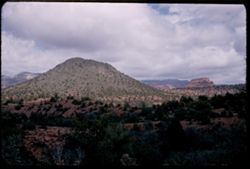
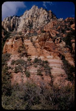
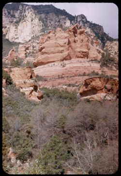
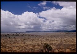
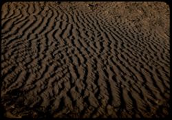
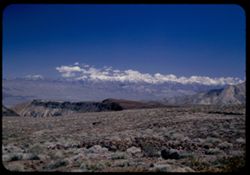
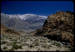
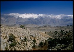
-
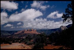
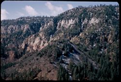
- Description:
- 25 f 9 Pola
- Subject:
- Canyons, Roads, Barbed wire, Trees, Tree limbs, Mountains, Fences, Shrubs, Clouds, Oak Creek Canyon (Ariz.), and Rock formations
- Series:
- 16-52
- Creator:
- Cushman, Charles W., 1896-1972
- Date Created:
- 1952-04-12
- Genre:
- Landscape photographs
- Frame Number:
- 33
- Street Address:
- United States Highway 89A
- County:
- Coconino
- Call Number:
- P06091
- City:
- Flagstaff
- Country:
- United States
- State/Province:
- Arizona
- Physical Description:
- Image was originally mounted in a glass enclosure. Before digitization, the image was removed and placed in a Wess Plastic, Inc. brand, 2" x 2", pl...
- Alternate Identifier:
- 1652.33
- Persistent URL:
- http://purl.dlib.indiana.edu/iudl/archives/cushman/P06091
- Holding Location:
- Bloomington - University Archives
Wells Library E460
1320 E 10th St.
Bloomington, IN 47405
Contact at archives@indiana.edu, 812-855-1127
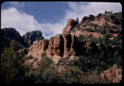
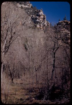
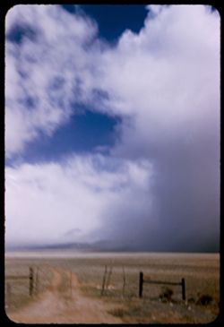
-
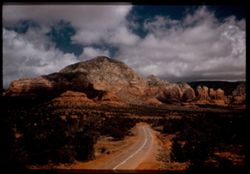
- Description:
- 25 f 9 Pola
- Subject:
- Roads, Trees, Mountains, Rock formations, Clouds, and Cliffs
- Series:
- 16-52
- Creator:
- Cushman, Charles W., 1896-1972
- Date Created:
- 1952-04-12
- Genre:
- Landscape photographs
- Frame Number:
- 32
- Street Address:
- United States Highway 89A
- County:
- Coconino
- Persons Pictured:
- Cushman, Charles W. (Charles Weever), 1896-1972
- Abstract:
- from same pt.
- Call Number:
- P06089
- City:
- Sedona
- Country:
- United States
- State/Province:
- Arizona
- Physical Description:
- Image was originally mounted in a glass enclosure. Before digitization, the image was removed and placed in a Wess Plastic, Inc. brand, 2" x 2", pl...
- Alternate Identifier:
- 1652.32
- Persistent URL:
- http://purl.dlib.indiana.edu/iudl/archives/cushman/P06089
- Holding Location:
- Bloomington - University Archives
Wells Library E460
1320 E 10th St.
Bloomington, IN 47405
Contact at archives@indiana.edu, 812-855-1127
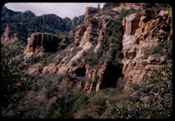
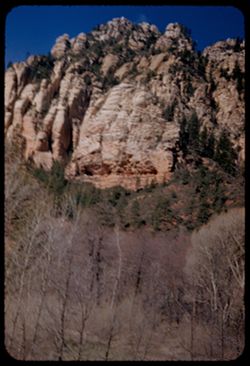
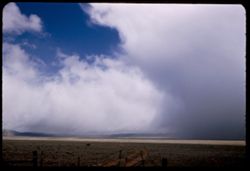
-
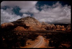
- Description:
- 25 f 9 Pola
- Subject:
- Cliffs, Trees, Mountains, Rock formations, Clouds, and Roads
- Series:
- 16-52
- Creator:
- Cushman, Charles W., 1896-1972
- Date Created:
- 1952-04-12
- Genre:
- Landscape photographs
- Frame Number:
- 32
- Street Address:
- United States Highway 89A
- County:
- Coconino
- Persons Pictured:
- Cushman, Charles W. (Charles Weever), 1896-1972
- Abstract:
- from same pt
- Call Number:
- P06090
- City:
- Sedona
- Country:
- United States
- State/Province:
- California
- Alternate Identifier:
- 1652.32
- Persistent URL:
- http://purl.dlib.indiana.edu/iudl/archives/cushman/P06090
- Holding Location:
- Bloomington - University Archives
Wells Library E460
1320 E 10th St.
Bloomington, IN 47405
Contact at archives@indiana.edu, 812-855-1127
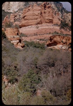
-
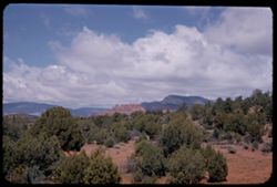
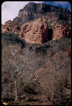
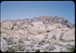
- Description:
- 25 f 11
- Subject:
- Canyons, Cliffs, Trees, Mountains, Shrubs, Clouds, Junipers, Rock formations, and Oak Creek Canyon (Ariz.)
- Series:
- 16-52
- Creator:
- Cushman, Charles W., 1896-1972
- Date Created:
- 1952-04-12
- Genre:
- Landscape photographs
- Frame Number:
- 30
- County:
- Coconino
- Abstract:
- Across the Juniper tops toward red
- Call Number:
- P06088
- City:
- Flagstaff
- Country:
- United States
- State/Province:
- Arizona
- Alternate Identifier:
- 1652.30
- Persistent URL:
- http://purl.dlib.indiana.edu/iudl/archives/cushman/P06088
- Holding Location:
- Bloomington - University Archives
Wells Library E460
1320 E 10th St.
Bloomington, IN 47405
Contact at archives@indiana.edu, 812-855-1127
-
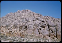
- Description:
- 25 f 11
- Subject:
- Canyons, Cliffs, Trees, Mountains, Shrubs, Clouds, Hills, Oak Creek Canyon (Ariz.), and Rock formations
- Series:
- 16-52
- Creator:
- Cushman, Charles W., 1896-1972
- Date Created:
- 1952-04-12
- Genre:
- Landscape photographs
- Frame Number:
- 29
- County:
- Coconino
- Abstract:
- Green pyramid
- Call Number:
- P06087
- Country:
- United States
- State/Province:
- Arizona
- Alternate Identifier:
- 1652.29
- Persistent URL:
- http://purl.dlib.indiana.edu/iudl/archives/cushman/P06087
- Holding Location:
- Bloomington - University Archives
Wells Library E460
1320 E 10th St.
Bloomington, IN 47405
Contact at archives@indiana.edu, 812-855-1127
-
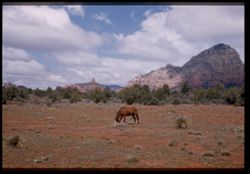
- Description:
- 25 f 11
- Subject:
- Cliffs, Horses, Trees, Mountains, Saddle Rock Ranch (Sedona, Calif.), Shrubs, and Rock formations
- Series:
- 16-52
- Creator:
- Cushman, Charles W., 1896-1972
- Date Created:
- 1952-04-12
- Genre:
- Landscape photographs
- Frame Number:
- 28
- Street Address:
- United States Highway 89A
- County:
- Coconino
- Persons Pictured:
- Cushman, Charles W. (Charles Weever), 1896-1972
- Abstract:
- Horse grazing at Saddle Rock ranch
- Call Number:
- P06086
- City:
- Sedona
- Country:
- United States
- State/Province:
- Arizona
- Physical Description:
- Image was originally mounted in a glass enclosure. Before digitization, the image was removed and placed in a Wess Plastic, Inc. brand, 2" x 2", pl...
- Alternate Identifier:
- 1652.28
- Persistent URL:
- http://purl.dlib.indiana.edu/iudl/archives/cushman/P06086
- Holding Location:
- Bloomington - University Archives
Wells Library E460
1320 E 10th St.
Bloomington, IN 47405
Contact at archives@indiana.edu, 812-855-1127
-
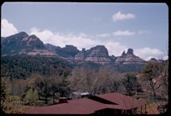
- Description:
- 25 f 10
- Subject:
- Canyons, Trees, Tree limbs, Mountains, Buildings, Rock formations, Hills, and Oak Creek Canyon (Ariz.)
- Series:
- 16-52
- Creator:
- Cushman, Charles W., 1896-1972
- Date Created:
- 1952-04-12
- Genre:
- Landscape photographs
- Frame Number:
- 27
- County:
- Coconino
- Abstract:
- Red monuments Spots
- Call Number:
- P06085
- Country:
- United States
- State/Province:
- Arizona
- Alternate Identifier:
- 1652.27
- Persistent URL:
- http://purl.dlib.indiana.edu/iudl/archives/cushman/P06085
- Holding Location:
- Bloomington - University Archives
Wells Library E460
1320 E 10th St.
Bloomington, IN 47405
Contact at archives@indiana.edu, 812-855-1127
-
- Description:
- 25 f 10
- Subject:
- Canyons, Cliffs, Trees, Mountains, Shrubs, Oak Creek Canyon (Ariz.), Sycamores, and Rock formations
- Series:
- 16-52
- Creator:
- Cushman, Charles W., 1896-1972
- Date Created:
- 1952-04-12
- Genre:
- Landscape photographs
- Frame Number:
- 26
- County:
- Coconino
- Abstract:
- Sycamore tops & red rocks Spots
- Call Number:
- P06084
- Country:
- United States
- State/Province:
- Arizona
- Alternate Identifier:
- 1652.26
- Persistent URL:
- http://purl.dlib.indiana.edu/iudl/archives/cushman/P06084
- Holding Location:
- Bloomington - University Archives
Wells Library E460
1320 E 10th St.
Bloomington, IN 47405
Contact at archives@indiana.edu, 812-855-1127
-
- Description:
- 25 f 13
- Subject:
- Oak Creek Canyon (Ariz.), Tree limbs, Canyons, Cliffs, Mountains, and Shrubs
- Series:
- 16-52
- Creator:
- Cushman, Charles W., 1896-1972
- Date Created:
- 1952-04-12
- Genre:
- Landscape photographs
- Frame Number:
- 25
- County:
- Coconino
- Abstract:
- [P] Spots
- Call Number:
- P06083
- Country:
- United States
- State/Province:
- Arizona
- Alternate Identifier:
- 1652.25
- Persistent URL:
- http://purl.dlib.indiana.edu/iudl/archives/cushman/P06083
- Holding Location:
- Bloomington - University Archives
Wells Library E460
1320 E 10th St.
Bloomington, IN 47405
Contact at archives@indiana.edu, 812-855-1127
-
- Description:
- 25 f 11
- Subject:
- Canyons, Cliffs, Trees, Mountains, Rock formations, Oak Creek Canyon (Ariz.), and Shrubs
- Series:
- 16-52
- Creator:
- Cushman, Charles W., 1896-1972
- Date Created:
- 1952-04-12
- Genre:
- Landscape photographs
- Frame Number:
- 24
- County:
- Coconino
- Abstract:
- [L] Spots
- Call Number:
- P06082
- City:
- Flagstaff
- Country:
- United States
- State/Province:
- Arizona
- Alternate Identifier:
- 1652.24
- Persistent URL:
- http://purl.dlib.indiana.edu/iudl/archives/cushman/P06082
- Holding Location:
- Bloomington - University Archives
Wells Library E460
1320 E 10th St.
Bloomington, IN 47405
Contact at archives@indiana.edu, 812-855-1127
-
- Description:
- 25 f 11
- Subject:
- Canyons, Roads, Trees, Tree limbs, Mountains, Tunnels, Oak Creek Canyon (Ariz.), Cliffs, Shrubs, and Rock formations
- Series:
- 16-52
- Creator:
- Cushman, Charles W., 1896-1972
- Date Created:
- 1952-04-12
- Genre:
- Landscape photographs
- Frame Number:
- 23
- County:
- Coconino
- Abstract:
- Across canyon Spots
- Call Number:
- P06081
- Country:
- United States
- State/Province:
- Arizona
- Alternate Identifier:
- 1652.23
- Persistent URL:
- http://purl.dlib.indiana.edu/iudl/archives/cushman/P06081
- Holding Location:
- Bloomington - University Archives
Wells Library E460
1320 E 10th St.
Bloomington, IN 47405
Contact at archives@indiana.edu, 812-855-1127
-
- Description:
- 25 f 11
- Subject:
- Canyons, Cliffs, Trees, Mountains, Rock formations, and Oak Creek Canyon (Ariz.)
- Series:
- 16-52
- Creator:
- Cushman, Charles W., 1896-1972
- Date Created:
- 1952-04-12
- Genre:
- Landscape photographs
- Frame Number:
- 22
- County:
- Coconino
- Abstract:
- Same at 25 f 11
- Call Number:
- P06080
- Country:
- United States
- State/Province:
- Arizona
- Alternate Identifier:
- 1652.22
- Persistent URL:
- http://purl.dlib.indiana.edu/iudl/archives/cushman/P06080
- Holding Location:
- Bloomington - University Archives
Wells Library E460
1320 E 10th St.
Bloomington, IN 47405
Contact at archives@indiana.edu, 812-855-1127
-
- Description:
- 25 f 8
- Subject:
- Oak Tree Canyon (Ariz.), Cliffs, Mountains, Trees, and Rock formations
- Series:
- 16-52
- Creator:
- Cushman, Charles W., 1896-1972
- Date Created:
- 1952-04-12
- Genre:
- Landscape photographs
- Frame Number:
- 21
- Abstract:
- High red jutting rock 25 f 8 by error
- Call Number:
- P06079
- Country:
- United States
- State/Province:
- Arizona
- Alternate Identifier:
- 1652.21
- Persistent URL:
- http://purl.dlib.indiana.edu/iudl/archives/cushman/P06079
- Holding Location:
- Bloomington - University Archives
Wells Library E460
1320 E 10th St.
Bloomington, IN 47405
Contact at archives@indiana.edu, 812-855-1127
-
- Description:
- 25 f 11
- Subject:
- Canyons, Cliffs, Trees, Mountains, Rock formations, and Oak Creek Canyon (Ariz.)
- Series:
- 16-52
- Creator:
- Cushman, Charles W., 1896-1972
- Date Created:
- 1952-04-12
- Genre:
- Landscape photographs
- Frame Number:
- 20
- County:
- Coconino
- Abstract:
- Trees & high oak
- Call Number:
- P06078
- Country:
- United States
- State/Province:
- Arizona
- Alternate Identifier:
- 1652.20
- Persistent URL:
- http://purl.dlib.indiana.edu/iudl/archives/cushman/P06078
- Holding Location:
- Bloomington - University Archives
Wells Library E460
1320 E 10th St.
Bloomington, IN 47405
Contact at archives@indiana.edu, 812-855-1127
-
- Description:
- 25 f 12
- Subject:
- Canyons, Cliffs, Trees, Mountains, Rock formations, and Oak Creek Canyon (Ariz.)
- Series:
- 16-52
- Creator:
- Cushman, Charles W., 1896-1972
- Date Created:
- 1952-04-12
- Genre:
- Landscape photographs
- Frame Number:
- 19
- County:
- Coconino
- Abstract:
- Colored rock across canyon
- Call Number:
- P06077
- Country:
- United States
- State/Province:
- Arizona
- Alternate Identifier:
- 1652.19
- Persistent URL:
- http://purl.dlib.indiana.edu/iudl/archives/cushman/P06077
- Holding Location:
- Bloomington - University Archives
Wells Library E460
1320 E 10th St.
Bloomington, IN 47405
Contact at archives@indiana.edu, 812-855-1127
-
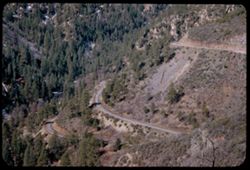
- Description:
- 50 f 6
- Subject:
- Canyons, Roads, Trees, Mountains, Shrubs, and Oak Creek Canyon (Ariz.)
- Series:
- 16-52
- Creator:
- Cushman, Charles W., 1896-1972
- Date Created:
- 1952-04-12
- Genre:
- Landscape photographs
- Frame Number:
- 18
- Street Address:
- United States Highway 89A
- County:
- Coconino
- Abstract:
- Road down into canyon
- Call Number:
- P06076
- Country:
- United States
- State/Province:
- Arizona
- Alternate Identifier:
- 1652.18
- Persistent URL:
- http://purl.dlib.indiana.edu/iudl/archives/cushman/P06076
- Holding Location:
- Bloomington - University Archives
Wells Library E460
1320 E 10th St.
Bloomington, IN 47405
Contact at archives@indiana.edu, 812-855-1127
-
- Description:
- 50 f 6.3
- Subject:
- Snow, Canyons, Cliffs, Trees, Mountains, and Oak Tree Canyon (Ariz.)
- Series:
- 16-52
- Creator:
- Cushman, Charles W., 1896-1972
- Date Created:
- 1952-04-12
- Genre:
- Landscape photographs
- Frame Number:
- 17
- County:
- Pima
- Abstract:
- Entering Oak Tree canyon from north
- Call Number:
- P06075
- Country:
- United States
- State/Province:
- Arizona
- Alternate Identifier:
- 1652.17
- Persistent URL:
- http://purl.dlib.indiana.edu/iudl/archives/cushman/P06075
- Holding Location:
- Bloomington - University Archives
Wells Library E460
1320 E 10th St.
Bloomington, IN 47405
Contact at archives@indiana.edu, 812-855-1127
-
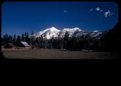
- Description:
- 50 f 6.3 Pola
- Subject:
- Snow, Barns, San Francisco Peaks (Ariz.), Farms, Trees, Croplands, and Mountains
- Series:
- 16-52
- Creator:
- Cushman, Charles W., 1896-1972
- Date Created:
- 1952-04-12
- Genre:
- Landscape photographs
- Frame Number:
- 16
- Street Address:
- Snow Bool Road
- County:
- Coconino
- Abstract:
- San Francisco Pks from Snow Bool road
- Call Number:
- P06074
- City:
- Flagstaff
- Country:
- United States
- State/Province:
- Arizona
- Physical Description:
- masked.
- Alternate Identifier:
- 1652.16
- Persistent URL:
- http://purl.dlib.indiana.edu/iudl/archives/cushman/P06074
- Holding Location:
- Bloomington - University Archives
Wells Library E460
1320 E 10th St.
Bloomington, IN 47405
Contact at archives@indiana.edu, 812-855-1127
-
- Description:
- 25 f 13
- Subject:
- Snow, Puddles, San Francisco Peaks (Ariz.), Trees, Mountains, Clouds, Hills, Rocks, Mud, Electric lines, and Bodies of water
- Series:
- 16-52
- Creator:
- Cushman, Charles W., 1896-1972
- Date Created:
- 1952-04-11
- Genre:
- Landscape photographs
- Frame Number:
- 15
- Street Address:
- United States Highway 66
- County:
- Coconino
- Abstract:
- San Francisco Pks-from 5 mi west of Flagstaff on 66
- Call Number:
- P06073
- City:
- Flagstaff
- Country:
- United States
- State/Province:
- Arizona
- Alternate Identifier:
- 1652.15
- Persistent URL:
- http://purl.dlib.indiana.edu/iudl/archives/cushman/P06073
- Holding Location:
- Bloomington - University Archives
Wells Library E460
1320 E 10th St.
Bloomington, IN 47405
Contact at archives@indiana.edu, 812-855-1127
-
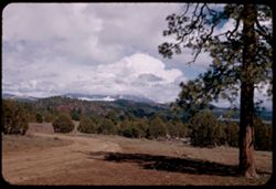
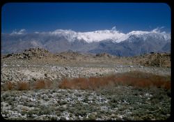
- Description:
- 25 f 13
- Subject:
- San Francisco Peaks (Ariz.), Dirt roads, Trees, Shadows, Tree limbs, Mountains, Clouds, Hills, and Roads
- Series:
- 16-52
- Creator:
- Cushman, Charles W., 1896-1972
- Date Created:
- 1952-04-11
- Genre:
- Landscape photographs
- Frame Number:
- 14
- County:
- Coconino
- Abstract:
- White cloud mass covers San Francisco Pks.(from 20 mi away)
- Call Number:
- P06072
- City:
- Flagstaff
- Country:
- United States
- State/Province:
- Arizona
- Alternate Identifier:
- 1652.14
- Persistent URL:
- http://purl.dlib.indiana.edu/iudl/archives/cushman/P06072
- Holding Location:
- Bloomington - University Archives
Wells Library E460
1320 E 10th St.
Bloomington, IN 47405
Contact at archives@indiana.edu, 812-855-1127
-
- Description:
- 25 f 8 Pola
- Subject:
- Plains, Hills, Barbed wire, Shrubs, Clouds, Mists, and Fences
- Series:
- 16-52
- Creator:
- Cushman, Charles W., 1896-1972
- Date Created:
- 1952-04-11
- Genre:
- Landscape photographs
- Frame Number:
- 13
- Street Address:
- United States Highway 66
- County:
- Yavapai
- Abstract:
- View SW from US 66 east of Seligman-showing rare mist formation
- Call Number:
- P06071
- City:
- Seligman
- Country:
- United States
- State/Province:
- Arizona
- Physical Description:
- Image was originally mounted in a glass enclosure. Before digitization, the image was removed and placed in a Wess Plastic, Inc. brand, 2" x 2", pl...
- Alternate Identifier:
- 1652.13
- Persistent URL:
- http://purl.dlib.indiana.edu/iudl/archives/cushman/P06071
- Holding Location:
- Bloomington - University Archives
Wells Library E460
1320 E 10th St.
Bloomington, IN 47405
Contact at archives@indiana.edu, 812-855-1127
-
- Description:
- 25 f 8 Pola
- Subject:
- Snow, Weather, Rain, Roads, Plains, Fences, Shrubs, and Clouds
- Series:
- 16-52
- Creator:
- Cushman, Charles W., 1896-1972
- Date Created:
- 1952-04-11
- Genre:
- Landscape photographs
- Frame Number:
- 12
- Street Address:
- United States Highway 66
- County:
- Yavapai and Mohave
- Abstract:
- Edge of snow or rain cloud ene of US 66 70 mi east of Kingman Ariz
- Call Number:
- P06070
- City:
- Kingman and Seligman
- Country:
- United States
- State/Province:
- Arizona
- Alternate Identifier:
- 1652.12
- Persistent URL:
- http://purl.dlib.indiana.edu/iudl/archives/cushman/P06070
- Holding Location:
- Bloomington - University Archives
Wells Library E460
1320 E 10th St.
Bloomington, IN 47405
Contact at archives@indiana.edu, 812-855-1127
-
- Description:
- 25 f 8 Pola
- Subject:
- Snow, Weather, Rain, Roads, Plains, Mountains, Fences, Shrubs, and Clouds
- Series:
- 16-52
- Creator:
- Cushman, Charles W., 1896-1972
- Date Created:
- 1952-04-11
- Genre:
- Landscape photographs
- Frame Number:
- 11
- Street Address:
- United States Highway 66
- County:
- Yavapai
- Abstract:
- Snow cloud-low east of US 66 near Seligman
- Call Number:
- P06069
- City:
- Seligman
- Country:
- United States
- State/Province:
- Arizona
- Alternate Identifier:
- 1652.11
- Persistent URL:
- http://purl.dlib.indiana.edu/iudl/archives/cushman/P06069
- Holding Location:
- Bloomington - University Archives
Wells Library E460
1320 E 10th St.
Bloomington, IN 47405
Contact at archives@indiana.edu, 812-855-1127
-
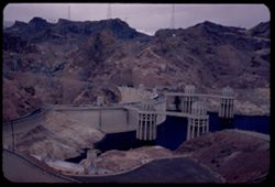
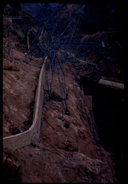
- Description:
- 25 f 5.6
- Subject:
- Towers, Hydraulic facilities, Canyons, Boulder Canyon (Ariz. and Nev.), Roads, Hydroelectric power, Hoover Dam (Ariz. and Nev.), Mountains, Lakes & pond...
- Series:
- 16-52
- Creator:
- Cushman, Charles W., 1896-1972
- Date Created:
- 1952-04-10
- Genre:
- Snapshots and Views
- Frame Number:
- 10
- Abstract:
- The Dam above on Arizona side
- Call Number:
- P06068
- Country:
- United States
- State/Province:
- Arizona
- Alternate Identifier:
- 1652.10
- Persistent URL:
- http://purl.dlib.indiana.edu/iudl/archives/cushman/P06068
- Holding Location:
- Bloomington - University Archives
Wells Library E460
1320 E 10th St.
Bloomington, IN 47405
Contact at archives@indiana.edu, 812-855-1127
-
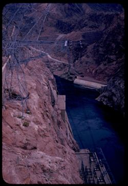
- Description:
- 25 f 5.6
- Subject:
- Lakes & ponds, Canyons, Dams, Walls, Black Canyon (Ariz. and Nev.), Hydroelectric generators, Boulder Canyon (Ariz. and Nev.), Hydraulic facilities, Mou...
- Series:
- 16-52
- Creator:
- Cushman, Charles W., 1896-1972
- Date Created:
- 1952-04-10
- Genre:
- Snapshots and Views
- Frame Number:
- 9
- Abstract:
- The Dam from above on Arizona side
- Call Number:
- P06067
- Country:
- United States
- State/Province:
- Arizona
- Alternate Identifier:
- 1652.9
- Persistent URL:
- http://purl.dlib.indiana.edu/iudl/archives/cushman/P06067
- Holding Location:
- Bloomington - University Archives
Wells Library E460
1320 E 10th St.
Bloomington, IN 47405
Contact at archives@indiana.edu, 812-855-1127
-

- Description:
- 25 f 5.6
- Subject:
- Lakes & ponds, Dams, Bodies of water, Hydroelectric generators, Cliffs, Hydraulic facilities, Electric lines, Hoover Dam (Ariz. and Nev.), Black Canyon (...
- Series:
- 16-52
- Creator:
- Cushman, Charles W., 1896-1972
- Date Created:
- 1952-04-10
- Genre:
- Snapshots
- Frame Number:
- 8
- Abstract:
- Wall on Nevada side
- Call Number:
- P06066
- Country:
- United States
- State/Province:
- Nevada
- Alternate Identifier:
- 1652.8
- Persistent URL:
- http://purl.dlib.indiana.edu/iudl/archives/cushman/P06066
- Holding Location:
- Bloomington - University Archives
Wells Library E460
1320 E 10th St.
Bloomington, IN 47405
Contact at archives@indiana.edu, 812-855-1127
-
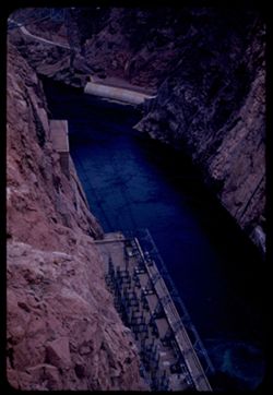
- Description:
- 25 f 4
- Subject:
- Mead, Lake (Ariz. and Nev.), Hydraulic facilities, Canyons, Boulder Canyon (Ariz. and Nev.), Cliffs, Hydroelectric power, Hoover Dam (Ariz. and Nev.), Lakes...
- Series:
- 16-52
- Creator:
- Cushman, Charles W., 1896-1972
- Date Created:
- 1952-04-10
- Genre:
- Snapshots and Views
- Frame Number:
- 7
- Abstract:
- Looking down into canyon below dam
- Call Number:
- P06065
- Country:
- United States
- State/Province:
- Arizona and Nevada
- Alternate Identifier:
- 1652.7
- Persistent URL:
- http://purl.dlib.indiana.edu/iudl/archives/cushman/P06065
- Holding Location:
- Bloomington - University Archives
Wells Library E460
1320 E 10th St.
Bloomington, IN 47405
Contact at archives@indiana.edu, 812-855-1127
-
- Description:
- 25 f 4.5
- Subject:
- Lakes & ponds, Canyons, Dams, Black Canyon (Ariz. and Nev.), Mead, Lake (Ariz. and Nev.), Hydroelectric generators, Boulder Canyon (Ariz. and Nev.), Ele...
- Series:
- 16-52
- Creator:
- Cushman, Charles W., 1896-1972
- Date Created:
- 1952-04-10
- Genre:
- Snapshots and Views
- Frame Number:
- 6
- Abstract:
- Looking down into canyon below dam
- Call Number:
- P06064
- Country:
- United States
- State/Province:
- Nevada and Arizona
- Alternate Identifier:
- 1652.6
- Persistent URL:
- http://purl.dlib.indiana.edu/iudl/archives/cushman/P06064
- Holding Location:
- Bloomington - University Archives
Wells Library E460
1320 E 10th St.
Bloomington, IN 47405
Contact at archives@indiana.edu, 812-855-1127
-
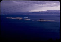
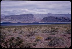
- Description:
- 25 f 6.3
- Subject:
- Mead, Lake (Ariz. and Nev.), Electric lines, Boats, Mountains, Lakes & ponds, and Islands
- Series:
- 16-52
- Creator:
- Cushman, Charles W., 1896-1972
- Date Created:
- 1952-04-10
- Genre:
- Landscape photographs and Seascapes
- Frame Number:
- 4
- County:
- Clark
- Abstract:
- Small boat in Lake Mead
- Call Number:
- P06063
- Country:
- United States
- State/Province:
- Nevada
- Alternate Identifier:
- 1652.4
- Persistent URL:
- http://purl.dlib.indiana.edu/iudl/archives/cushman/P06063
- Holding Location:
- Bloomington - University Archives
Wells Library E460
1320 E 10th St.
Bloomington, IN 47405
Contact at archives@indiana.edu, 812-855-1127
-
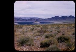
- Description:
- 50 f 11
- Subject:
- Rocks, Mead, Lake (Ariz. and Nev.), Mountains, Shrubs, Lakes & ponds, Islands, and Wildflowers
- Series:
- 16-52
- Creator:
- Cushman, Charles W., 1896-1972
- Date Created:
- 1952-04-10
- Genre:
- Landscape photographs
- Frame Number:
- 2
- Abstract:
- Lake Mead-an arm
- Call Number:
- P06062
- Country:
- United States
- State/Province:
- Arizona and Nevada
- Alternate Identifier:
- 1652.2
- Persistent URL:
- http://purl.dlib.indiana.edu/iudl/archives/cushman/P06062
- Holding Location:
- Bloomington - University Archives
Wells Library E460
1320 E 10th St.
Bloomington, IN 47405
Contact at archives@indiana.edu, 812-855-1127
-
- Description:
- 50 f 9
- Subject:
- Wildflowers, Bays (Bodies of water), Hoover Dam (Ariz. and Nev.), Mountains, Shrubs, Lakes & ponds, Islands, Hills, and Mead, Lake (Ariz. and Nev.)
- Series:
- 16-52
- Creator:
- Cushman, Charles W., 1896-1972
- Date Created:
- 1952-04-10
- Genre:
- Landscape photographs
- Frame Number:
- 1
- County:
- Clark
- Abstract:
- Mtn top in bay of L. Mead.
- Call Number:
- P06061
- Country:
- United States
- State/Province:
- Nevada
- Physical Description:
- masked.
- Alternate Identifier:
- 1652.1
- Persistent URL:
- http://purl.dlib.indiana.edu/iudl/archives/cushman/P06061
- Holding Location:
- Bloomington - University Archives
Wells Library E460
1320 E 10th St.
Bloomington, IN 47405
Contact at archives@indiana.edu, 812-855-1127
-
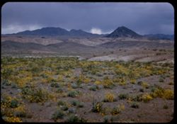
- Description:
- 25 f 8
- Subject:
- Wildflowers, Mead, Lake (Ariz. and Nev.), Mountains, Rock formations, Clouds, Hills, Deserts, Pyramidal mountain, and Shrubs
- Series:
- 15-52
- Creator:
- Cushman, Charles W., 1896-1972
- Date Created:
- 1952-04-10
- Genre:
- Landscape photographs
- Frame Number:
- 41
- County:
- Clark
- Abstract:
- Yellow desert flowers + pyramidal mtn. near Lake Mead.
- Call Number:
- P06060
- Country:
- United States
- State/Province:
- Nevada
- Alternate Identifier:
- 1542.41
- Persistent URL:
- http://purl.dlib.indiana.edu/iudl/archives/cushman/P06060
- Holding Location:
- Bloomington - University Archives
Wells Library E460
1320 E 10th St.
Bloomington, IN 47405
Contact at archives@indiana.edu, 812-855-1127
-
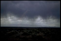
- Description:
- 25 f 6.3 Pola
- Subject:
- Weather, Rain, Hoover Dam (Ariz. and Nev.), Storms, Shrubs, Clouds, Utility poles, Electric lines, and Boulder Canyon (Ariz. and Nev.)
- Series:
- 15-52
- Creator:
- Cushman, Charles W., 1896-1972
- Date Created:
- 1952-04-09
- Genre:
- Landscape photographs
- Frame Number:
- 40
- County:
- Clark
- Abstract:
- Storm cloud near Hoover Dam.
- Call Number:
- P06059
- Country:
- United States
- State/Province:
- Nevada
- Physical Description:
- Image was originally mounted in a glass enclosure. Before digitization, the image was removed and placed in a Wess Plastic, Inc. brand, 2" x 2", pl...
- Alternate Identifier:
- 1542.40
- Persistent URL:
- http://purl.dlib.indiana.edu/iudl/archives/cushman/P06059
- Holding Location:
- Bloomington - University Archives
Wells Library E460
1320 E 10th St.
Bloomington, IN 47405
Contact at archives@indiana.edu, 812-855-1127
-
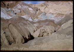
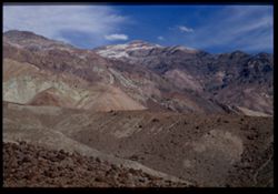
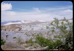
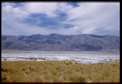
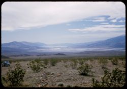
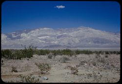
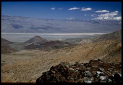
- Description:
- 25 f 16
- Subject:
- Deserts, Valleys, Cliffs, Shadows, Mountains, Rock formations, Death Valley (Calif. and Nev.), and Hills
- Series:
- 15-52
- Creator:
- Cushman, Charles W., 1896-1972
- Date Created:
- 1952-04-09
- Genre:
- Landscape photographs
- Frame Number:
- 39
- Street Address:
- Artists Drive
- Abstract:
- From top of Artists Drive. Kaleidoscopic view.
- Call Number:
- P06058
- Country:
- United States
- State/Province:
- California
- Physical Description:
- Image was originally mounted in a glass enclosure. Before digitization, the image was removed and placed in a Wess Plastic, Inc. brand, 2" x 2", pl...
- Alternate Identifier:
- 1552.39
- Persistent URL:
- http://purl.dlib.indiana.edu/iudl/archives/cushman/P06058
- Holding Location:
- Bloomington - University Archives
Wells Library E460
1320 E 10th St.
Bloomington, IN 47405
Contact at archives@indiana.edu, 812-855-1127
-

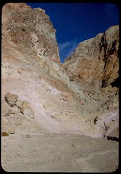
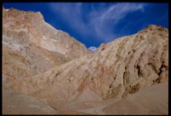
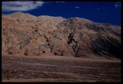
- Description:
- 25 f 13
- Subject:
- Rocks, Colored mountains, Valleys, Cliffs, Mountains, Rock formations, Death Valley (Calif. and Nev.), Deserts, and Hills
- Series:
- 15-52
- Creator:
- Cushman, Charles W., 1896-1972
- Date Created:
- 1952-04-09
- Genre:
- Landscape photographs
- Frame Number:
- 38
- Street Address:
- Artists Drive
- County:
- Inyo
- Abstract:
- From top of Artists Drive. Off Artists Drive.
- Call Number:
- P06057
- Country:
- United States
- State/Province:
- California
- Alternate Identifier:
- 1552.38
- Persistent URL:
- http://purl.dlib.indiana.edu/iudl/archives/cushman/P06057
- Holding Location:
- Bloomington - University Archives
Wells Library E460
1320 E 10th St.
Bloomington, IN 47405
Contact at archives@indiana.edu, 812-855-1127
-
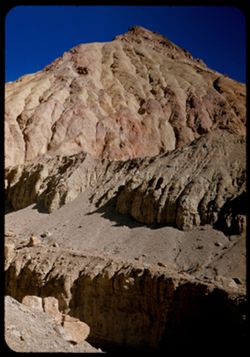
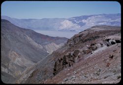
- Description:
- 25 f 16
- Subject:
- Rocks, Valleys, Cliffs, Boulders, Mountains, Death Valley (Calif. and Nev.), and Deserts
- Series:
- 15-52
- Creator:
- Cushman, Charles W., 1896-1972
- Date Created:
- 1952-04-09
- Genre:
- Landscape photographs
- Frame Number:
- 37
- Street Address:
- Artists Drive
- County:
- Inyo
- Abstract:
- From top of Artists Drive. Up from Artists Dr.
- Call Number:
- P06056
- Country:
- United States
- State/Province:
- California
- Alternate Identifier:
- 1552.37
- Persistent URL:
- http://purl.dlib.indiana.edu/iudl/archives/cushman/P06056
- Holding Location:
- Bloomington - University Archives
Wells Library E460
1320 E 10th St.
Bloomington, IN 47405
Contact at archives@indiana.edu, 812-855-1127
-
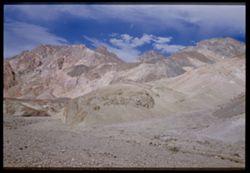
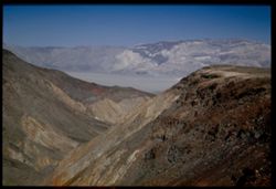
- Description:
- 25 f 16
- Subject:
- Deserts, Valleys, Cliffs, Mountains, Rock formations, and Death Valley (Calif. and Nev.)
- Series:
- 15-52
- Creator:
- Cushman, Charles W., 1896-1972
- Date Created:
- 1952-04-09
- Genre:
- Snapshots
- Frame Number:
- 36
- Street Address:
- Artists Drive
- County:
- Inyo
- Abstract:
- From top of Artists Drive. Up from Artists Dr.
- Call Number:
- P06055
- Country:
- United States
- State/Province:
- California
- Alternate Identifier:
- 1552.36
- Persistent URL:
- http://purl.dlib.indiana.edu/iudl/archives/cushman/P06055
- Holding Location:
- Bloomington - University Archives
Wells Library E460
1320 E 10th St.
Bloomington, IN 47405
Contact at archives@indiana.edu, 812-855-1127
-
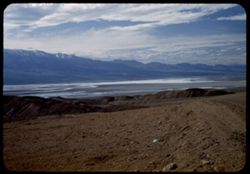
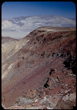
- Description:
- 25 f 8 Pola
- Subject:
- Deserts, Valleys, Hills, Death Valley (Calif. and Nev.), Mountains, Rocks, and Clouds
- Series:
- 15-52
- Creator:
- Cushman, Charles W., 1896-1972
- Date Created:
- 1952-04-09
- Genre:
- Landscape photographs
- Frame Number:
- 35
- Street Address:
- Artists Drive
- County:
- Inyo
- Abstract:
- From top of Artists Drive. Back across valley.
- Call Number:
- P06054
- Country:
- United States
- State/Province:
- California
- Alternate Identifier:
- 1552.35
- Persistent URL:
- http://purl.dlib.indiana.edu/iudl/archives/cushman/P06054
- Holding Location:
- Bloomington - University Archives
Wells Library E460
1320 E 10th St.
Bloomington, IN 47405
Contact at archives@indiana.edu, 812-855-1127
-
- Description:
- 25 f 16
- Subject:
- Deserts, Valleys, Cliffs, Mountains, Hills, and Death Valley (Calif. and Nev.)
- Series:
- 15-52
- Creator:
- Cushman, Charles W., 1896-1972
- Date Created:
- 1952-04-09
- Genre:
- Landscape photographs
- Frame Number:
- 34
- Street Address:
- Artists Drive
- County:
- Inyo
- Abstract:
- From top of Artists Drive. Up.
- Call Number:
- P06053
- Country:
- United States
- State/Province:
- California
- Physical Description:
- Image was originally mounted in a glass enclosure. Before digitization, the image was removed and placed in a Wess Plastic, Inc. brand, 2" x 2", pl...
- Alternate Identifier:
- 1552.34
- Persistent URL:
- http://purl.dlib.indiana.edu/iudl/archives/cushman/P06053
- Holding Location:
- Bloomington - University Archives
Wells Library E460
1320 E 10th St.
Bloomington, IN 47405
Contact at archives@indiana.edu, 812-855-1127
-
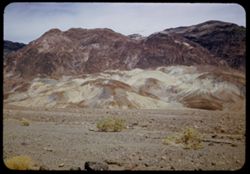
- Description:
- 25 f 13
- Subject:
- Rocks, Colored mountains, Valleys, Cliffs, Boulders, Mountains, Rock formations, Death Valley (Calif. and Nev.), Deserts, and Hills
- Series:
- 15-52
- Creator:
- Cushman, Charles W., 1896-1972
- Date Created:
- 1952-04-09
- Genre:
- Landscape photographs
- Frame Number:
- 33
- Street Address:
- Artists Drive
- County:
- Inyo
- Abstract:
- Colored mtns from Artists Drive.
- Call Number:
- P06052
- Country:
- United States
- State/Province:
- California
- Physical Description:
- Image was originally mounted in a glass enclosure. Before digitization, the image was removed and placed in a Wess Plastic, Inc. brand, 2" x 2", pl...
- Alternate Identifier:
- 1552.33
- Persistent URL:
- http://purl.dlib.indiana.edu/iudl/archives/cushman/P06052
- Holding Location:
- Bloomington - University Archives
Wells Library E460
1320 E 10th St.
Bloomington, IN 47405
Contact at archives@indiana.edu, 812-855-1127
-
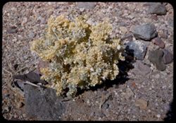
- Description:
- 25 f 16
- Subject:
- Valleys, Rocks, Death Valley (Calif. and Nev.), Deserts, and Shrubs
- Series:
- 15-52
- Creator:
- Cushman, Charles W., 1896-1972
- Date Created:
- 1952-04-09
- Genre:
- Identification photographs
- Frame Number:
- 32
- County:
- Inyo
- Abstract:
- Desert holly.
- Call Number:
- P06051
- Country:
- United States
- State/Province:
- California
- Alternate Identifier:
- 1552.32
- Persistent URL:
- http://purl.dlib.indiana.edu/iudl/archives/cushman/P06051
- Holding Location:
- Bloomington - University Archives
Wells Library E460
1320 E 10th St.
Bloomington, IN 47405
Contact at archives@indiana.edu, 812-855-1127
-
- Description:
- 25 f 13
- Subject:
- Deserts, Valleys, Mountains, Hills, Rocks, and Death Valley (Calif. and Nev.)
- Series:
- 15-52
- Creator:
- Cushman, Charles W., 1896-1972
- Date Created:
- 1952-04-09
- Genre:
- Landscape photographs
- Frame Number:
- 31
- Street Address:
- Artists Drive
- County:
- Inyo
- Abstract:
- Mtns from Atrists Drive.
- Call Number:
- P06050
- Country:
- United States
- State/Province:
- California
- Physical Description:
- Image was originally mounted in a glass enclosure. Before digitization, the image was removed and placed in a Wess Plastic, Inc. brand, 2" x 2", pl...
- Alternate Identifier:
- 1552.31
- Persistent URL:
- http://purl.dlib.indiana.edu/iudl/archives/cushman/P06050
- Holding Location:
- Bloomington - University Archives
Wells Library E460
1320 E 10th St.
Bloomington, IN 47405
Contact at archives@indiana.edu, 812-855-1127
-
- Description:
- 25 f 9 Pola
- Subject:
- Lakes & ponds, Deserts, Valleys, Death Valley (Calif. and Nev.), Roads, Cliffs, Mountains, Boulders, and Rocks
- Series:
- 15-52
- Creator:
- Cushman, Charles W., 1896-1972
- Date Created:
- 1952-04-09
- Genre:
- Snapshots
- Frame Number:
- 29
- County:
- Inyo
- Abstract:
- Mtns at Bad Water, 279.6 ft. below
- Call Number:
- P06049
- City:
- Badwater
- Country:
- United States
- State/Province:
- California
- Alternate Identifier:
- 1552.29
- Persistent URL:
- http://purl.dlib.indiana.edu/iudl/archives/cushman/P06049
- Holding Location:
- Bloomington - University Archives
Wells Library E460
1320 E 10th St.
Bloomington, IN 47405
Contact at archives@indiana.edu, 812-855-1127
-
- Description:
- 25 f 13
- Subject:
- Lakes & ponds, Deserts, Reflections, Valleys, Death Valley (Calif. and Nev.), Roads, Cliffs, Mountains, Women, Boulders, and Rocks
- Series:
- 15-52
- Creator:
- Cushman, Charles W., 1896-1972
- Date Created:
- 1952-04-09
- Genre:
- Portraits and Snapshots
- Frame Number:
- 28
- County:
- Inyo
- Persons Pictured:
- Cushman, Jean
- Abstract:
- Mtns at Bad Water, 279.6 ft. below.
- Call Number:
- P06048
- City:
- Badwater
- Country:
- United States
- State/Province:
- California
- Alternate Identifier:
- 1552.28
- Persistent URL:
- http://purl.dlib.indiana.edu/iudl/archives/cushman/P06048
- Holding Location:
- Bloomington - University Archives
Wells Library E460
1320 E 10th St.
Bloomington, IN 47405
Contact at archives@indiana.edu, 812-855-1127
-
- Description:
- 25 f 11 Pola
- Subject:
- Deserts, Amargosa Range (Nev. and Calif.), Valleys, Death Valley (Calif. and Nev.), Mountains, and Rocks
- Series:
- 15-52
- Creator:
- Cushman, Charles W., 1896-1972
- Date Created:
- 1952-04-09
- Genre:
- Landscape photographs
- Frame Number:
- 27
- County:
- Inyo
- Abstract:
- Amargosa Mtns near Bad Water.
- Call Number:
- P06047
- City:
- Badwater
- Country:
- United States
- State/Province:
- California
- Physical Description:
- Image was originally mounted in a glass enclosure. Before digitization, the image was removed and placed in a Wess Plastic, Inc. brand, 2" x 2", pl...
- Alternate Identifier:
- 1552.27
- Persistent URL:
- http://purl.dlib.indiana.edu/iudl/archives/cushman/P06047
- Holding Location:
- Bloomington - University Archives
Wells Library E460
1320 E 10th St.
Bloomington, IN 47405
Contact at archives@indiana.edu, 812-855-1127
-
- Description:
- 25 f 8 Pola
- Subject:
- Bodies of water, Telescope Peak (Inyo County, Calif.), Hills, Mountains, Death Valley (Calif. and Nev.), Deserts, Shrubs, Valleys, and Snow
- Series:
- 15-52
- Creator:
- Cushman, Charles W., 1896-1972
- Date Created:
- 1952-04-09
- Genre:
- Landscape photographs
- Frame Number:
- 25
- County:
- Inyo
- Abstract:
- Telescope Pk. from Bad Water. 280 ft. below sea level.
- Call Number:
- P06045
- City:
- Badwater
- Country:
- United States
- State/Province:
- California
- Physical Description:
- Image was originally mounted in a glass enclosure. Before digitization, the image was removed and placed in a Wess Plastic, Inc. brand, 2" x 2", pl...
- Alternate Identifier:
- 1552.25
- Persistent URL:
- http://purl.dlib.indiana.edu/iudl/archives/cushman/P06045
- Holding Location:
- Bloomington - University Archives
Wells Library E460
1320 E 10th St.
Bloomington, IN 47405
Contact at archives@indiana.edu, 812-855-1127
-
- Description:
- 25 f 9 Pola
- Subject:
- Deserts, Valleys, Mountains, Death Valley (Calif. and Nev.), Amargosa Range (Nev. and Calif.), and Rocks
- Series:
- 15-52
- Creator:
- Cushman, Charles W., 1896-1972
- Date Created:
- 1952-04-09
- Genre:
- Landscape photographs
- Frame Number:
- 26
- County:
- Inyo
- Abstract:
- Amargosa Mtns near Bad Water.
- Call Number:
- P06046
- City:
- Badwater
- Country:
- United States
- State/Province:
- California
- Physical Description:
- Image was originally mounted in a glass enclosure. Before digitization, the image was removed and placed in a Wess Plastic, Inc. brand, 2" x 2", pl...
- Alternate Identifier:
- 1552.26
- Persistent URL:
- http://purl.dlib.indiana.edu/iudl/archives/cushman/P06046
- Holding Location:
- Bloomington - University Archives
Wells Library E460
1320 E 10th St.
Bloomington, IN 47405
Contact at archives@indiana.edu, 812-855-1127
-
- Description:
- 25 f 9 Pola
- Subject:
- Deserts, Valleys, Salt pools, Mountains, Shrubs, Hills, Black Mountains (Inyo County, Calif.), Rocks, and Death Valley (Calif. and Nev.)
- Series:
- 15-52
- Creator:
- Cushman, Charles W., 1896-1972
- Date Created:
- 1952-04-09
- Genre:
- Landscape photographs
- Frame Number:
- 24
- County:
- Inyo
- Abstract:
- Colored Mtns. The Black Mtns - near Salt Pools this time.
- Call Number:
- P06044
- Country:
- United States
- State/Province:
- California
- Alternate Identifier:
- 1552.24
- Persistent URL:
- http://purl.dlib.indiana.edu/iudl/archives/cushman/P06044
- Holding Location:
- Bloomington - University Archives
Wells Library E460
1320 E 10th St.
Bloomington, IN 47405
Contact at archives@indiana.edu, 812-855-1127
-

- Description:
- 25 f 9 Pola
- Subject:
- Deserts, Valleys, Hills, Death Valley (Calif. and Nev.), Mountains, Colored mountains, Rocks, Rock formations, and Black Mountains (Inyo County, Calif.)
- Series:
- 15-52
- Creator:
- Cushman, Charles W., 1896-1972
- Date Created:
- 1952-04-09
- Genre:
- Landscape photographs
- Frame Number:
- 23
- County:
- Inyo
- Abstract:
- Colored Mtns. The Black Mtns.
- Call Number:
- P06043
- Country:
- United States
- State/Province:
- California
- Alternate Identifier:
- 1552.23
- Persistent URL:
- http://purl.dlib.indiana.edu/iudl/archives/cushman/P06043
- Holding Location:
- Bloomington - University Archives
Wells Library E460
1320 E 10th St.
Bloomington, IN 47405
Contact at archives@indiana.edu, 812-855-1127
-
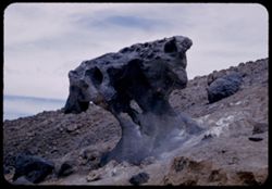
- Description:
- 25 f 10
- Subject:
- Deserts, Mushroom Rock (Inyo County, Calif.), Boulders, Rock formations, Hills, Rocks, Valleys, and Death Valley (Calif. and Nev.)
- Series:
- 15-52
- Creator:
- Cushman, Charles W., 1896-1972
- Date Created:
- 1952-04-09
- Genre:
- Snapshots
- Frame Number:
- 22
- County:
- Inyo
- Abstract:
- Mushroom rock.
- Call Number:
- P06042
- City:
- Furnace Creek
- Country:
- United States
- State/Province:
- California
- Alternate Identifier:
- 1552.22
- Persistent URL:
- http://purl.dlib.indiana.edu/iudl/archives/cushman/P06042
- Holding Location:
- Bloomington - University Archives
Wells Library E460
1320 E 10th St.
Bloomington, IN 47405
Contact at archives@indiana.edu, 812-855-1127
-

- Description:
- 25 f 14
- Subject:
- Deserts, Amargosa Range (Nev. and Calif.), Valleys, Hills, Death Valley (Calif. and Nev.), Cliffs, Mountains, Shrubs, Rocks, Canyons, and Desolation Canyon (...
- Series:
- 15-52
- Creator:
- Cushman, Charles W., 1896-1972
- Date Created:
- 1952-04-09
- Genre:
- Landscape photographs
- Frame Number:
- 21
- Street Address:
- Bad Water Road
- County:
- Inyo
- Abstract:
- Approx. same.
- Call Number:
- P06041
- City:
- Furnace Creek
- Country:
- United States
- State/Province:
- California
- Alternate Identifier:
- 1552.21
- Persistent URL:
- http://purl.dlib.indiana.edu/iudl/archives/cushman/P06041
- Holding Location:
- Bloomington - University Archives
Wells Library E460
1320 E 10th St.
Bloomington, IN 47405
Contact at archives@indiana.edu, 812-855-1127
-
- Description:
- 25 f 9 Pola
- Subject:
- Deserts, Valleys, Mountains, Death Valley (Calif. and Nev.), Canyons, Hills, and Desolation Canyon (Calif.)
- Series:
- 15-52
- Creator:
- Cushman, Charles W., 1896-1972
- Date Created:
- 1952-04-09
- Genre:
- Landscape photographs
- Frame Number:
- 20
- County:
- Inyo
- Abstract:
- From road to Bad Water toward Desolation Canyon.
- Call Number:
- P06040
- City:
- Furnace Creek and Badwater
- Country:
- United States
- State/Province:
- California
- Alternate Identifier:
- 1552.20
- Persistent URL:
- http://purl.dlib.indiana.edu/iudl/archives/cushman/P06040
- Holding Location:
- Bloomington - University Archives
Wells Library E460
1320 E 10th St.
Bloomington, IN 47405
Contact at archives@indiana.edu, 812-855-1127
-
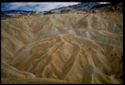
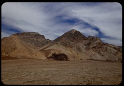
- Description:
- 25 f 11 Pola
- Subject:
- Deserts, Valleys, Mountains, Rock formations, Zabriskie Point (Calif.), and Death Valley (Calif. and Nev.)
- Series:
- 15-52
- Creator:
- Cushman, Charles W., 1896-1972
- Date Created:
- 1952-04-09
- Genre:
- Landscape photographs
- Frame Number:
- 19
- County:
- Inyo
- Abstract:
- East + down from Zab. Pt.
- Call Number:
- P06039
- City:
- Furnace Creek
- Country:
- United States
- State/Province:
- California
- Physical Description:
- Image was originally mounted in a glass enclosure. Before digitization, the image was removed and placed in a Wess Plastic, Inc. brand, 2" x 2", pl...
- Alternate Identifier:
- 1552.19
- Persistent URL:
- http://purl.dlib.indiana.edu/iudl/archives/cushman/P06039
- Holding Location:
- Bloomington - University Archives
Wells Library E460
1320 E 10th St.
Bloomington, IN 47405
Contact at archives@indiana.edu, 812-855-1127
-
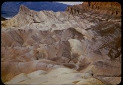
- Description:
- 25 f 9 Pola
- Subject:
- Deserts, Valleys, Mountains, Rock formations, Zabriskie Point (Calif.), and Death Valley (Calif. and Nev.)
- Series:
- 15-52
- Creator:
- Cushman, Charles W., 1896-1972
- Date Created:
- 1952-04-09
- Genre:
- Landscape photographs
- Frame Number:
- 18
- County:
- Inyo
- Abstract:
- NW from out on shoulder.
- Call Number:
- P06038
- City:
- Furnace Creek
- Country:
- United States
- State/Province:
- California
- Alternate Identifier:
- 1552.18
- Persistent URL:
- http://purl.dlib.indiana.edu/iudl/archives/cushman/P06038
- Holding Location:
- Bloomington - University Archives
Wells Library E460
1320 E 10th St.
Bloomington, IN 47405
Contact at archives@indiana.edu, 812-855-1127
-
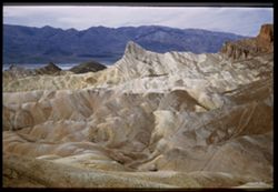
- Description:
- 25 f 8 Pola
- Subject:
- Deserts, Valleys, Cliffs, Mountains, Rock formations, Zabriskie Point (Calif.), and Death Valley (Calif. and Nev.)
- Series:
- 15-52
- Creator:
- Cushman, Charles W., 1896-1972
- Date Created:
- 1952-04-09
- Genre:
- Landscape photographs
- Frame Number:
- 17
- County:
- Inyo
- Abstract:
- West from north of Pt.
- Call Number:
- P06037
- City:
- Furnace Creek
- Country:
- United States
- State/Province:
- California
- Physical Description:
- Image was originally mounted in a glass enclosure. Before digitization, the image was removed and placed in a Wess Plastic, Inc. brand, 2" x 2", pl...
- Alternate Identifier:
- 1552.17
- Persistent URL:
- http://purl.dlib.indiana.edu/iudl/archives/cushman/P06037
- Holding Location:
- Bloomington - University Archives
Wells Library E460
1320 E 10th St.
Bloomington, IN 47405
Contact at archives@indiana.edu, 812-855-1127
-
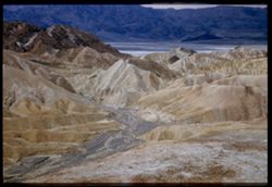
- Description:
- 25 f 9 Pola
- Subject:
- Deserts, Valleys, Cliffs, Mountains, Zabriskie Point (Calif.), Death Valley (Calif. and Nev.), Streams, and Hills
- Series:
- 15-52
- Creator:
- Cushman, Charles W., 1896-1972
- Date Created:
- 1952-04-09
- Genre:
- Landscape photographs
- Frame Number:
- 16
- County:
- Inyo
- Abstract:
- West from Zabriskie Pt.
- Call Number:
- P06036
- City:
- Furnace Creek
- Country:
- United States
- State/Province:
- California
- Physical Description:
- Image was originally mounted in a glass enclosure. Before digitization, the image was removed and placed in a Wess Plastic, Inc. brand, 2" x 2", pl...
- Alternate Identifier:
- 1552.16
- Persistent URL:
- http://purl.dlib.indiana.edu/iudl/archives/cushman/P06036
- Holding Location:
- Bloomington - University Archives
Wells Library E460
1320 E 10th St.
Bloomington, IN 47405
Contact at archives@indiana.edu, 812-855-1127
-
- Description:
- 25 f 13
- Subject:
- Rocks, Mesquite, Valleys, Cliffs, Women, Mountains, Shrubs, Death Valley (Calif. and Nev.), Utility poles, Furnace Creek (Calif.), and Hills
- Series:
- 15-52
- Creator:
- Cushman, Charles W., 1896-1972
- Date Created:
- 1952-04-09
- Genre:
- Landscape photographs and Portraits
- Frame Number:
- 14
- County:
- Inyo
- Persons Pictured:
- Cushman, Jean
- Abstract:
- Mesquite and green rocks. (near Furnace Creek)
- Call Number:
- P06035
- Country:
- United States
- State/Province:
- California
- Alternate Identifier:
- 1552.14
- Persistent URL:
- http://purl.dlib.indiana.edu/iudl/archives/cushman/P06035
- Holding Location:
- Bloomington - University Archives
Wells Library E460
1320 E 10th St.
Bloomington, IN 47405
Contact at archives@indiana.edu, 812-855-1127
-
- Description:
- 25 f 8 Pola
- Subject:
- Deserts, Valleys, Mountains, Shrubs, and Death Valley (Calif. and Nev.)
- Series:
- 15-52
- Creator:
- Cushman, Charles W., 1896-1972
- Date Created:
- 1952-04-09
- Genre:
- Landscape photographs
- Frame Number:
- 13
- County:
- Inyo
- Abstract:
- View WSW across valley.
- Call Number:
- P06034
- Country:
- United States
- State/Province:
- California
- Physical Description:
- Image was originally mounted in a glass enclosure. Before digitization, the image was removed and placed in a Wess Plastic, Inc. brand, 2" x 2", pl...
- Alternate Identifier:
- 1552.13
- Persistent URL:
- http://purl.dlib.indiana.edu/iudl/archives/cushman/P06034
- Holding Location:
- Bloomington - University Archives
Wells Library E460
1320 E 10th St.
Bloomington, IN 47405
Contact at archives@indiana.edu, 812-855-1127
-
- Description:
- 25 f 6.3 Pola
- Subject:
- Deserts, Valleys, Hills, Automobiles, Death Valley (Calif. and Nev.), Roads, Mountains, Shrubs, and Rocks
- Series:
- 15-52
- Creator:
- Cushman, Charles W., 1896-1972
- Date Created:
- 1952-04-09
- Genre:
- Landscape photographs
- Frame Number:
- 12
- County:
- Inyo
- Abstract:
- Death Valley from north.
- Call Number:
- P06033
- City:
- Beatty Junction
- Country:
- United States
- State/Province:
- California
- Alternate Identifier:
- 1552.12
- Persistent URL:
- http://purl.dlib.indiana.edu/iudl/archives/cushman/P06033
- Holding Location:
- Bloomington - University Archives
Wells Library E460
1320 E 10th St.
Bloomington, IN 47405
Contact at archives@indiana.edu, 812-855-1127
-
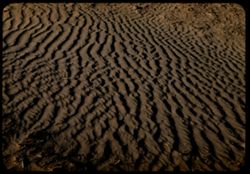
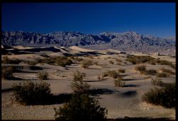
- Description:
- 25 f 8 Pola
- Subject:
- Deserts, Ripples, Valleys, Sand, Dunes, and Death Valley (Calif. and Nev.)
- Series:
- 15-52
- Creator:
- Cushman, Charles W., 1896-1972
- Date Created:
- 1952-04-08
- Genre:
- Snapshots
- Frame Number:
- 11
- County:
- Inyo
- Abstract:
- Sand ripples.
- Call Number:
- P06032
- City:
- Stovepipe Wells
- Country:
- United States
- State/Province:
- California
- Alternate Identifier:
- 1552.11
- Persistent URL:
- http://purl.dlib.indiana.edu/iudl/archives/cushman/P06032
- Holding Location:
- Bloomington - University Archives
Wells Library E460
1320 E 10th St.
Bloomington, IN 47405
Contact at archives@indiana.edu, 812-855-1127
-
- Description:
- 25 f 8 Pola (with screen turned)
- Subject:
- Deserts, Ripples, Valleys, Sand, Dunes, and Death Valley (Calif. and Nev.)
- Series:
- 15-52
- Creator:
- Cushman, Charles W., 1896-1972
- Date Created:
- 1952-04-08
- Genre:
- Snapshots
- Frame Number:
- 10
- County:
- Inyo
- Abstract:
- Sand ripples.
- Call Number:
- P06031
- City:
- Stovepipe Wells
- Country:
- United States
- State/Province:
- California
- Alternate Identifier:
- 1552.10
- Persistent URL:
- http://purl.dlib.indiana.edu/iudl/archives/cushman/P06031
- Holding Location:
- Bloomington - University Archives
Wells Library E460
1320 E 10th St.
Bloomington, IN 47405
Contact at archives@indiana.edu, 812-855-1127
-
- Description:
- 25 f 8 Pola
- Subject:
- Deserts, Valleys, Sand, Dunes, Mountains, Shrubs, and Death Valley (Calif. and Nev.)
- Series:
- 15-52
- Creator:
- Cushman, Charles W., 1896-1972
- Date Created:
- 1952-04-01
- Genre:
- Landscape photographs
- Frame Number:
- 9
- County:
- Inyo
- Abstract:
- Sand Dunes near Stovepipe Wells.
- Call Number:
- P06030
- City:
- Stovepipe Wells
- Country:
- United States
- State/Province:
- California
- Physical Description:
- Image was originally mounted in a glass enclosure. Before digitization, the image was removed and placed in a Wess Plastic, Inc. brand, 2" x 2", pl...
- Alternate Identifier:
- 1552.9
- Persistent URL:
- http://purl.dlib.indiana.edu/iudl/archives/cushman/P06030
- Holding Location:
- Bloomington - University Archives
Wells Library E460
1320 E 10th St.
Bloomington, IN 47405
Contact at archives@indiana.edu, 812-855-1127
-
- Description:
- 25 f 13
- Subject:
- Rocks, Valleys, Panamint Range (Calif.), Panamint Mountains (Calif.), Argus Range (Calif.), Boulders, Mountains, Rock Candy Mountain (Calif.), Shrubs, Panami...
- Series:
- 15-52
- Creator:
- Cushman, Charles W., 1896-1972
- Date Created:
- 1952-04-08
- Genre:
- Landscape photographs
- Frame Number:
- 7
- Street Address:
- California State Highway 190
- County:
- Inyo
- Abstract:
- Red earth at Rock Candy mtn. (Panamint).
- Call Number:
- P06028
- City:
- Panamint
- Country:
- United States
- State/Province:
- California
- Alternate Identifier:
- 1552.7
- Persistent URL:
- http://purl.dlib.indiana.edu/iudl/archives/cushman/P06028
- Holding Location:
- Bloomington - University Archives
Wells Library E460
1320 E 10th St.
Bloomington, IN 47405
Contact at archives@indiana.edu, 812-855-1127
-
- Description:
- 25 f 9 Pola
- Subject:
- Panamint Mountains (Calif.), Valleys, Panamint Valley (Calif.), Panamint Range (Calif.), Shrubs, Rocks, and Mountains
- Series:
- 15-52
- Creator:
- Cushman, Charles W., 1896-1972
- Date Created:
- 1952-04-08
- Genre:
- Landscape photographs
- Frame Number:
- 8
- County:
- Inyo
- Abstract:
- Across Panamint Valley to Panamint Mtns from Panamint Springs.
- Call Number:
- P06029
- City:
- Panamint Springs
- Country:
- United States
- State/Province:
- California
- Alternate Identifier:
- 1552.8
- Persistent URL:
- http://purl.dlib.indiana.edu/iudl/archives/cushman/P06029
- Holding Location:
- Bloomington - University Archives
Wells Library E460
1320 E 10th St.
Bloomington, IN 47405
Contact at archives@indiana.edu, 812-855-1127
-
- Description:
- 25 f 8 Pola
- Subject:
- Deserts, Valleys, Roads, Mountains, Shrubs, Panamint Valley (Calif.), Hills, Rocks, Panamint Range (Calif.), and Death Valley (Calif. and Nev.)
- Series:
- 15-52
- Creator:
- Cushman, Charles W., 1896-1972
- Date Created:
- 1952-04-08
- Genre:
- Landscape photographs
- Frame Number:
- 6
- County:
- Inyo
- Abstract:
- Road is straight across Panamint Valley.
- Call Number:
- P06027
- Country:
- United States
- State/Province:
- California
- Physical Description:
- Image was originally mounted in a glass enclosure. Before digitization, the image was removed and placed in a Wess Plastic, Inc. brand, 2" x 2", pl...
- Alternate Identifier:
- 1552.6
- Persistent URL:
- http://purl.dlib.indiana.edu/iudl/archives/cushman/P06027
- Holding Location:
- Bloomington - University Archives
Wells Library E460
1320 E 10th St.
Bloomington, IN 47405
Contact at archives@indiana.edu, 812-855-1127
-
- Description:
- 25 f 13
- Subject:
- Rocks, Valleys, Panamint Range (Calif.), Argus Range (Calif.), Boulders, Mountains, Shrubs, Panamint Valley (Calif.), Canyons, and Cliffs
- Series:
- 15-52
- Creator:
- Cushman, Charles W., 1896-1972
- Date Created:
- 1952-04-08
- Genre:
- Landscape photographs
- Frame Number:
- 5
- County:
- Inyo
- Abstract:
- Flatbed of Panamint Valley from same pt. A gap in Argus Range.
- Call Number:
- P06026
- Country:
- United States
- State/Province:
- California
- Alternate Identifier:
- 1552.5
- Persistent URL:
- http://purl.dlib.indiana.edu/iudl/archives/cushman/P06026
- Holding Location:
- Bloomington - University Archives
Wells Library E460
1320 E 10th St.
Bloomington, IN 47405
Contact at archives@indiana.edu, 812-855-1127
-
- Description:
- 25 f 9
- Subject:
- Panamint Mountains (Calif.), Deserts, Canyons, Valleys, Death Valley (Calif. and Nev.), Panamint Valley (Calif.), Mountains, Cliffs, and Panamint Range (Calif.)
- Series:
- 15-52
- Creator:
- Cushman, Charles W., 1896-1972
- Date Created:
- 1952-04-01
- Genre:
- Landscape photographs
- Frame Number:
- 3
- County:
- Inyo
- Abstract:
- Mouth of Canyon into Panamint Valley - Panamint Mtns in distance.
- Call Number:
- P06024
- Country:
- United States
- State/Province:
- California
- Physical Description:
- Image was originally mounted in a glass enclosure. Before digitization, the image was removed and placed in a Wess Plastic, Inc. brand, 2" x 2", pl...
- Alternate Identifier:
- 1552.3
- Persistent URL:
- http://purl.dlib.indiana.edu/iudl/archives/cushman/P06024
- Holding Location:
- Bloomington - University Archives
Wells Library E460
1320 E 10th St.
Bloomington, IN 47405
Contact at archives@indiana.edu, 812-855-1127
-
- Description:
- 25 f 8 Pola
- Subject:
- Deserts, Valleys, Panamint Range (Calif.), Panamint Mountains (Calif.), Argus Range (Calif.), Mountains, Shrubs, Panamint Valley (Calif.), Death Valley (Cali...
- Series:
- 15-52
- Creator:
- Cushman, Charles W., 1896-1972
- Date Created:
- 1952-04-08
- Genre:
- Landscape photographs
- Frame Number:
- 4
- County:
- Inyo
- Abstract:
- Same [P]
- Call Number:
- P06025
- Country:
- United States
- State/Province:
- California
- Alternate Identifier:
- 1552.4
- Persistent URL:
- http://purl.dlib.indiana.edu/iudl/archives/cushman/P06025
- Holding Location:
- Bloomington - University Archives
Wells Library E460
1320 E 10th St.
Bloomington, IN 47405
Contact at archives@indiana.edu, 812-855-1127
-
- Description:
- 25 f 8 Pola
- Subject:
- Snow, Panamint Range (Calif.), Mountains, Shrubs, Clouds, Hills, and Rocks
- Series:
- 15-52
- Creator:
- Cushman, Charles W., 1896-1972
- Date Created:
- 1952-04-08
- Genre:
- Landscape photographs
- Frame Number:
- 2
- Street Address:
- California State Highway 190
- County:
- Inyo
- Abstract:
- Snow-covered Panamints from Hwy 190 40 mi. from Lone Pine.
- Call Number:
- P06023
- City:
- Lone Pine
- Country:
- United States
- State/Province:
- California
- Alternate Identifier:
- 1552.2
- Persistent URL:
- http://purl.dlib.indiana.edu/iudl/archives/cushman/P06023
- Holding Location:
- Bloomington - University Archives
Wells Library E460
1320 E 10th St.
Bloomington, IN 47405
Contact at archives@indiana.edu, 812-855-1127
-
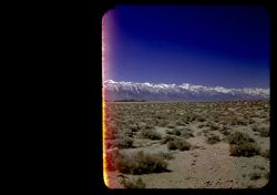
- Description:
- 25 f 8 Pola
- Subject:
- Snow, Mountains, Shrubs, Sierra Nevada (Calif. and Nev.), and Hills
- Series:
- 15-52
- Creator:
- Cushman, Charles W., 1896-1972
- Date Created:
- 1952-04-08
- Genre:
- Landscape photographs
- Frame Number:
- 1
- Street Address:
- California State Highway 190
- County:
- Inyo
- Abstract:
- The very high Sierras from Hwy 190 twenty five miles east of Lone Pine.
- Call Number:
- P06022
- City:
- Lone Pine
- Country:
- United States
- State/Province:
- California
- Physical Description:
- masked.
- Alternate Identifier:
- 1552.1
- Persistent URL:
- http://purl.dlib.indiana.edu/iudl/archives/cushman/P06022
- Holding Location:
- Bloomington - University Archives
Wells Library E460
1320 E 10th St.
Bloomington, IN 47405
Contact at archives@indiana.edu, 812-855-1127
-
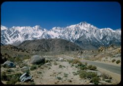
- Description:
- 25 f 8 Pola
- Subject:
- Snow, Roads, Boulders, Mountains, Rock formations, Whitney, Mount (Calif.), Sierra Nevada (Calif. and Nev.), Hills, Rocks, Lone Pine Peak (Calif.), and Shrubs
- Series:
- 14-52
- Creator:
- Cushman, Charles W., 1896-1972
- Date Created:
- 1952-04-08
- Genre:
- Landscape photographs
- Frame Number:
- 37
- County:
- Inyo
- Abstract:
- Whitney's neighbors + the south again.
- Call Number:
- P06020
- Country:
- United States
- State/Province:
- California
- Alternate Identifier:
- 1452.37
- Persistent URL:
- http://purl.dlib.indiana.edu/iudl/archives/cushman/P06020
- Holding Location:
- Bloomington - University Archives
Wells Library E460
1320 E 10th St.
Bloomington, IN 47405
Contact at archives@indiana.edu, 812-855-1127
-
- Description:
- 25 f 8 Pola
- Subject:
- Snow, Grasses, Barbed wire, Trees, Mountains, Fences, Shrubs, and Inyo Mountains (Calif.)
- Series:
- 14-52
- Creator:
- Cushman, Charles W., 1896-1972
- Date Created:
- 1952-04-08
- Genre:
- Landscape photographs
- Frame Number:
- 38
- County:
- Inyo
- Abstract:
- Inyo Mtns from Lone Pine.
- Call Number:
- P06021
- City:
- Lone Pine
- Country:
- United States
- State/Province:
- California
- Physical Description:
- Image was originally mounted in a glass enclosure. Before digitization, the image was removed and placed in a Wess Plastic, Inc. brand, 2" x 2", pl...
- Alternate Identifier:
- 1452.38
- Persistent URL:
- http://purl.dlib.indiana.edu/iudl/archives/cushman/P06021
- Holding Location:
- Bloomington - University Archives
Wells Library E460
1320 E 10th St.
Bloomington, IN 47405
Contact at archives@indiana.edu, 812-855-1127
-
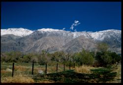
- Description:
- 25 f 8 Pola
- Subject:
- Snow, Valleys, Inyo Mountains (Calif.), Boulders, Owens Valley (Calif.), Mountains, Shrubs, Hills, Rocks, Alabama Hills (Calif.), and Rock formations
- Series:
- 14-52
- Creator:
- Cushman, Charles W., 1896-1972
- Date Created:
- 1952-04-08
- Genre:
- Landscape photographs
- Frame Number:
- 36
- Street Address:
- Mount Whitney Road
- County:
- Inyo
- Abstract:
- View across valley weird rock at it.
- Call Number:
- P06019
- Country:
- United States
- State/Province:
- California
- Alternate Identifier:
- 1452.36
- Persistent URL:
- http://purl.dlib.indiana.edu/iudl/archives/cushman/P06019
- Holding Location:
- Bloomington - University Archives
Wells Library E460
1320 E 10th St.
Bloomington, IN 47405
Contact at archives@indiana.edu, 812-855-1127
-
- Description:
- 25 f 11
- Subject:
- Rocks, Boulders, Alabama Hills (Calif.), Hills, Shrubs, and Rock formations
- Series:
- 14-52
- Creator:
- Cushman, Charles W., 1896-1972
- Date Created:
- 1952-04-08
- Genre:
- Landscape photographs
- Frame Number:
- 35
- County:
- Inyo
- Abstract:
- Gorilla + shark.
- Call Number:
- P06018
- City:
- Lone Pine
- Country:
- United States
- State/Province:
- California
- Alternate Identifier:
- 1452.35
- Persistent URL:
- http://purl.dlib.indiana.edu/iudl/archives/cushman/P06018
- Holding Location:
- Bloomington - University Archives
Wells Library E460
1320 E 10th St.
Bloomington, IN 47405
Contact at archives@indiana.edu, 812-855-1127
-
- Description:
- 25 f 11
- Subject:
- Hills, Shrubs, Boulders, Alabama Hills (Calif.), Rock formations, and Rocks
- Series:
- 14-52
- Creator:
- Cushman, Charles W., 1896-1972
- Date Created:
- 1952-04-08
- Genre:
- Snapshots
- Frame Number:
- 34
- County:
- Inyo
- Abstract:
- Same from dif. angle.
- Call Number:
- P06017
- City:
- Lone Pine
- Country:
- United States
- State/Province:
- California
- Alternate Identifier:
- 1452.34
- Persistent URL:
- http://purl.dlib.indiana.edu/iudl/archives/cushman/P06017
- Holding Location:
- Bloomington - University Archives
Wells Library E460
1320 E 10th St.
Bloomington, IN 47405
Contact at archives@indiana.edu, 812-855-1127
-

- Description:
- 25 f 11
- Subject:
- Hills, Mountains, Shrubs, Boulders, Rocks, Rock formations, and Crazy rocks
- Series:
- 14-52
- Creator:
- Cushman, Charles W., 1896-1972
- Date Created:
- 1952-04-08
- Genre:
- Landscape photographs
- Frame Number:
- 33
- Street Address:
- Mount Whitney Road
- County:
- Inyo
- Abstract:
- Crazy rocks along lower Mt. Whitney rd.
- Call Number:
- P06016
- City:
- Lone Pine
- Country:
- United States
- State/Province:
- California
- Alternate Identifier:
- 1452.33
- Persistent URL:
- http://purl.dlib.indiana.edu/iudl/archives/cushman/P06016
- Holding Location:
- Bloomington - University Archives
Wells Library E460
1320 E 10th St.
Bloomington, IN 47405
Contact at archives@indiana.edu, 812-855-1127
-
- Description:
- 25 f 8 Pola
- Subject:
- Rocks, Inyo Mountains (Calif.), Boulders, Owens Valley (Calif.), Mountains, Shrubs, Hills, and Snow
- Series:
- 14-52
- Creator:
- Cushman, Charles W., 1896-1972
- Date Created:
- 1952-04-08
- Genre:
- Landscape photographs
- Frame Number:
- 32
- Street Address:
- Mount Whitney Road
- County:
- Inyo
- Abstract:
- Across Owens Valley to Inyo Mtns.
- Call Number:
- P06015
- City:
- Lone Pine
- Country:
- United States
- State/Province:
- California
- Alternate Identifier:
- 1452.32
- Persistent URL:
- http://purl.dlib.indiana.edu/iudl/archives/cushman/P06015
- Holding Location:
- Bloomington - University Archives
Wells Library E460
1320 E 10th St.
Bloomington, IN 47405
Contact at archives@indiana.edu, 812-855-1127
-
- Description:
- 25 f 8 Pola
- Subject:
- Rocks, Valleys, Inyo Mountains (Calif.), Trees, Boulders, Owens Valley (Calif.), Mountains, Shrubs, Hills, and Snow
- Series:
- 14-52
- Creator:
- Cushman, Charles W., 1896-1972
- Date Created:
- 1952-04-08
- Genre:
- Landscape photographs
- Frame Number:
- 31
- Street Address:
- Mount Whitney Road
- County:
- Inyo
- Abstract:
- Owens Valley from Mt. Whitney Rd.
- Call Number:
- P06014
- Country:
- United States
- State/Province:
- California
- Physical Description:
- Image was originally mounted in a glass enclosure. Before digitization, the image was removed and placed in a Wess Plastic, Inc. brand, 2" x 2", pl...
- Alternate Identifier:
- 1452.31
- Persistent URL:
- http://purl.dlib.indiana.edu/iudl/archives/cushman/P06014
- Holding Location:
- Bloomington - University Archives
Wells Library E460
1320 E 10th St.
Bloomington, IN 47405
Contact at archives@indiana.edu, 812-855-1127
-
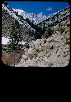
- Description:
- 25 f 9 Pola
- Subject:
- Whitney, Mount (Calif.), Mountains, Shrubs, Snow, Trees, Rocks, Portal station, Rock formations, and Boulders
- Series:
- 14-52
- Creator:
- Cushman, Charles W., 1896-1972
- Date Created:
- 1952-04-08
- Genre:
- Landscape photographs
- Frame Number:
- 29
- County:
- Inyo
- Abstract:
- Whitney from Portal Station.
- Call Number:
- P06013
- Country:
- United States
- State/Province:
- California
- Physical Description:
- masked.
- Alternate Identifier:
- 1452.29
- Persistent URL:
- http://purl.dlib.indiana.edu/iudl/archives/cushman/P06013
- Holding Location:
- Bloomington - University Archives
Wells Library E460
1320 E 10th St.
Bloomington, IN 47405
Contact at archives@indiana.edu, 812-855-1127
-
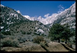
- Description:
- 25 f 13
- Subject:
- Snow, Roads, Trees, Mountains, Rock formations, Whitney, Mount (Calif.), Sierra Nevada (Calif. and Nev.), Shrubs, and Clouds
- Series:
- 14-52
- Creator:
- Cushman, Charles W., 1896-1972
- Date Created:
- 1952-04-08
- Genre:
- Landscape photographs
- Frame Number:
- 28
- County:
- Inyo
- Abstract:
- Mt. Whitney + spires.
- Call Number:
- P06012
- Country:
- United States
- State/Province:
- California
- Physical Description:
- Image was originally mounted in a glass enclosure. Before digitization, the image was removed and placed in a Wess Plastic, Inc. brand, 2" x 2", pl...
- Alternate Identifier:
- 1452.28
- Persistent URL:
- http://purl.dlib.indiana.edu/iudl/archives/cushman/P06012
- Holding Location:
- Bloomington - University Archives
Wells Library E460
1320 E 10th St.
Bloomington, IN 47405
Contact at archives@indiana.edu, 812-855-1127
-
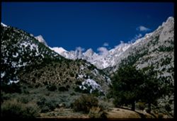
- Description:
- 25 f 9 Pola
- Subject:
- Snow, Trees, Mountains, Shrubs, Whitney, Mount (Calif.), Sierra Nevada (Calif. and Nev.), Rock formations, and Clouds
- Series:
- 14-52
- Creator:
- Cushman, Charles W., 1896-1972
- Date Created:
- 1952-04-08
- Genre:
- Landscape photographs
- Frame Number:
- 27
- Street Address:
- Lone Pine-Whitney Road
- County:
- Placer and Inyo
- Abstract:
- Mt. Whitney + spires.
- Call Number:
- P06011
- City:
- Lone Pine
- Country:
- United States
- State/Province:
- California
- Physical Description:
- Image was originally mounted in a glass enclosure. Before digitization, the image was removed and placed in a Wess Plastic, Inc. brand, 2" x 2", pl...
- Alternate Identifier:
- 1452.27
- Persistent URL:
- http://purl.dlib.indiana.edu/iudl/archives/cushman/P06011
- Holding Location:
- Bloomington - University Archives
Wells Library E460
1320 E 10th St.
Bloomington, IN 47405
Contact at archives@indiana.edu, 812-855-1127
-
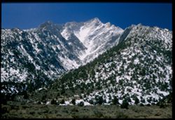
- Description:
- 25 f 6.3 Pola
- Subject:
- Snow, Trees, Mountains, Shrubs, Whitney, Mount (Calif.), Sierra Nevada (Calif. and Nev.), and Langley, Mount (Calif.)
- Series:
- 14-52
- Creator:
- Cushman, Charles W., 1896-1972
- Date Created:
- 1952-04-08
- Genre:
- Landscape photographs
- Frame Number:
- 26
- County:
- Inyo
- Abstract:
- Whitney's SE neighbor again. Mt. Langley, 14,042.
- Call Number:
- P06010
- City:
- Lone Pine
- Country:
- United States
- State/Province:
- California
- Physical Description:
- Image was originally mounted in a glass enclosure. Before digitization, the image was removed and placed in a Wess Plastic, Inc. brand, 2" x 2", pl...
- Alternate Identifier:
- 1452.26
- Persistent URL:
- http://purl.dlib.indiana.edu/iudl/archives/cushman/P06010
- Holding Location:
- Bloomington - University Archives
Wells Library E460
1320 E 10th St.
Bloomington, IN 47405
Contact at archives@indiana.edu, 812-855-1127
-
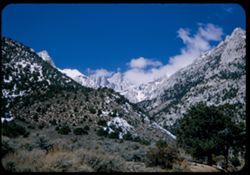
- Description:
- 25 f 13
- Subject:
- Snow, Trees, Mountains, Shrubs, Whitney, Mount (Calif.), Sierra Nevada (Calif. and Nev.), and Clouds
- Series:
- 14-52
- Creator:
- Cushman, Charles W., 1896-1972
- Date Created:
- 1952-04-08
- Genre:
- Landscape photographs
- Frame Number:
- 25
- County:
- Inyo
- Abstract:
- Whitney's peak.
- Call Number:
- P06009
- Country:
- United States
- State/Province:
- California
- Alternate Identifier:
- 1452.25
- Persistent URL:
- http://purl.dlib.indiana.edu/iudl/archives/cushman/P06009
- Holding Location:
- Bloomington - University Archives
Wells Library E460
1320 E 10th St.
Bloomington, IN 47405
Contact at archives@indiana.edu, 812-855-1127
-
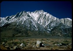
- Description:
- 25 f 9 Pola
- Subject:
- Rocks, Lone Pine Peak (Calif.), Mountains, Shrubs, Sierra Nevada (Calif. and Nev.), Langley, Mount (Calif.), Snow, and Boulders
- Series:
- 14-52
- Creator:
- Cushman, Charles W., 1896-1972
- Date Created:
- 1952-04-08
- Genre:
- Landscape photographs
- Frame Number:
- 24
- County:
- Inyo
- Abstract:
- Same high peak - Langley, 14,042.
- Call Number:
- P06008
- Country:
- United States
- State/Province:
- California
- Alternate Identifier:
- 1452.24
- Persistent URL:
- http://purl.dlib.indiana.edu/iudl/archives/cushman/P06008
- Holding Location:
- Bloomington - University Archives
Wells Library E460
1320 E 10th St.
Bloomington, IN 47405
Contact at archives@indiana.edu, 812-855-1127
-
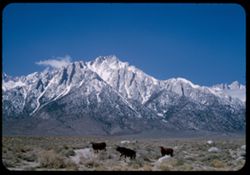
- Description:
- 50 f 10
- Subject:
- Lone Pine Peak (Calif.), Cows, Langley, Mount (Calif.), Whitney, Mount (Calif.), Mountains, Shrubs, Snow, Rocks, Farms, and Sierra Nevada (Calif. and Nev.)
- Series:
- 14-52
- Creator:
- Cushman, Charles W., 1896-1972
- Date Created:
- 1953-04-08
- Genre:
- Landscape photographs
- Frame Number:
- 23
- County:
- Inyo
- Abstract:
- 3 cows + high peak. SE of Whitney. Langley, 14,042.
- Call Number:
- P06007
- City:
- Lone Pine
- Country:
- United States
- State/Province:
- California
- Alternate Identifier:
- 1452.23
- Persistent URL:
- http://purl.dlib.indiana.edu/iudl/archives/cushman/P06007
- Holding Location:
- Bloomington - University Archives
Wells Library E460
1320 E 10th St.
Bloomington, IN 47405
Contact at archives@indiana.edu, 812-855-1127
-
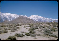
- Description:
- 50 f 10
- Subject:
- Snow, Boulders, Mountains, Shrubs, Whitney, Mount (Calif.), Sierra Nevada (Calif. and Nev.), and Hills
- Series:
- 14-52
- Creator:
- Cushman, Charles W., 1896-1972
- Date Created:
- 1952-04-08
- Genre:
- Landscape photographs
- Frame Number:
- 22
- Street Address:
- Mount Whitney Road
- County:
- Inyo
- Abstract:
- And those to north.
- Call Number:
- P06006
- City:
- Lone Pine
- Country:
- United States
- State/Province:
- California
- Alternate Identifier:
- 1452.22
- Persistent URL:
- http://purl.dlib.indiana.edu/iudl/archives/cushman/P06006
- Holding Location:
- Bloomington - University Archives
Wells Library E460
1320 E 10th St.
Bloomington, IN 47405
Contact at archives@indiana.edu, 812-855-1127
-
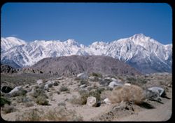
- Description:
- 50 f 9
- Subject:
- Hills, Roads, Whitney, Mount (Calif.), Mountains, Shrubs, Sierra Nevada (Calif. and Nev.), Boulders, Rocks, Rock formations, and Snow
- Series:
- 14-52
- Creator:
- Cushman, Charles W., 1896-1972
- Date Created:
- 1952-04-08
- Genre:
- Landscape photographs
- Frame Number:
- 21
- County:
- Inyo
- Abstract:
- Whitney's neighbors to the South.
- Call Number:
- P06005
- Country:
- United States
- State/Province:
- California
- Alternate Identifier:
- 1452.21
- Persistent URL:
- http://purl.dlib.indiana.edu/iudl/archives/cushman/P06005
- Holding Location:
- Bloomington - University Archives
Wells Library E460
1320 E 10th St.
Bloomington, IN 47405
Contact at archives@indiana.edu, 812-855-1127
-
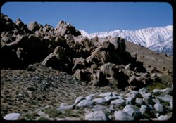
- Description:
- 50 f 9
- Subject:
- Hills, Mountains, Shrubs, Sierra Nevada (Calif. and Nev.), Boulders, Rocks, Rock formations, Snow, and Alabama Hills (Calif.)
- Series:
- 14-52
- Creator:
- Cushman, Charles W., 1896-1972
- Date Created:
- 1952-04-08
- Genre:
- Landscape photographs
- Frame Number:
- 20
- County:
- Inyo
- Abstract:
- Big bad rocks of Alabama hills.
- Call Number:
- P06004
- City:
- Lone Pine
- Country:
- United States
- State/Province:
- California
- Alternate Identifier:
- 1452.20
- Persistent URL:
- http://purl.dlib.indiana.edu/iudl/archives/cushman/P06004
- Holding Location:
- Bloomington - University Archives
Wells Library E460
1320 E 10th St.
Bloomington, IN 47405
Contact at archives@indiana.edu, 812-855-1127
-
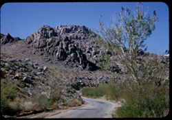
- Description:
- 50 f 8
- Subject:
- Rocks, Roads, Trees, Boulders, Alabama Hills (Calif.), Whitney, Mount (Calif.), Hills, Shrubs, and Rock formations
- Series:
- 14-52
- Creator:
- Cushman, Charles W., 1896-1972
- Date Created:
- 1952-04-08
- Genre:
- Landscape photographs
- Frame Number:
- 19
- Street Address:
- Mount Whitney Road
- County:
- Inyo
- Abstract:
- One of the Alabama Hills on Mt. Whitney Rd.
- Call Number:
- P06003
- City:
- Lone Pine
- Country:
- United States
- State/Province:
- California
- Alternate Identifier:
- 1452.19
- Persistent URL:
- http://purl.dlib.indiana.edu/iudl/archives/cushman/P06003
- Holding Location:
- Bloomington - University Archives
Wells Library E460
1320 E 10th St.
Bloomington, IN 47405
Contact at archives@indiana.edu, 812-855-1127
-

- Description:
- 50 f 9
- Subject:
- Hills, Roads, Whitney, Mount (Calif.), Mountains, Shrubs, Sierra Nevada (Calif. and Nev.), Trees, Rocks, Fences, Snow, Boulders, and Buildings
- Series:
- 14-52
- Creator:
- Cushman, Charles W., 1896-1972
- Date Created:
- 1952-04-08
- Genre:
- Landscape photographs
- Frame Number:
- 18
- County:
- Inyo
- Abstract:
- Mt. Whitney at dead center.
- Call Number:
- P06002
- Country:
- United States
- State/Province:
- California
- Alternate Identifier:
- 1452.18
- Persistent URL:
- http://purl.dlib.indiana.edu/iudl/archives/cushman/P06002
- Holding Location:
- Bloomington - University Archives
Wells Library E460
1320 E 10th St.
Bloomington, IN 47405
Contact at archives@indiana.edu, 812-855-1127
-
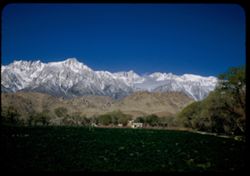
- Description:
- 25 f 8 Pola
- Subject:
- Croplands, Hills, Whitney, Mount (Calif.), Mountains, Shrubs, Snow, Trees, Farms, Clouds, Agricultural facilities, and Sierra Nevada (Calif. and Nev.)
- Series:
- 14-52
- Creator:
- Cushman, Charles W., 1896-1972
- Date Created:
- 1952-04-08
- Genre:
- Landscape photographs
- Frame Number:
- 17
- County:
- Inyo
- Abstract:
- Mt. Whitney this time.
- Call Number:
- P06001
- City:
- Lone Pine
- Country:
- United States
- State/Province:
- California
- Alternate Identifier:
- 1452.17
- Persistent URL:
- http://purl.dlib.indiana.edu/iudl/archives/cushman/P06001
- Holding Location:
- Bloomington - University Archives
Wells Library E460
1320 E 10th St.
Bloomington, IN 47405
Contact at archives@indiana.edu, 812-855-1127
-
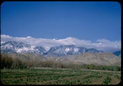
- Description:
- 50 f 9
- Subject:
- Snow, Trees, Croplands, Clouds, Sierra Nevada (Calif. and Nev.), Hills, Mountains, and Whitney, Mount (Calif.)
- Series:
- 14-52
- Creator:
- Cushman, Charles W., 1896-1972
- Date Created:
- 1952-04-08
- Genre:
- Landscape photographs
- Frame Number:
- 16
- County:
- Inyo
- Abstract:
- Mt. Whitney et al. Behind cloud.
- Call Number:
- P06000
- City:
- Lone Pine
- Country:
- United States
- State/Province:
- California
- Alternate Identifier:
- 1452.16
- Persistent URL:
- http://purl.dlib.indiana.edu/iudl/archives/cushman/P06000
- Holding Location:
- Bloomington - University Archives
Wells Library E460
1320 E 10th St.
Bloomington, IN 47405
Contact at archives@indiana.edu, 812-855-1127
-

- Description:
- 50 f 9
- Subject:
- Snow, Houses, Farms, Trees, Croplands, Fences, Whitney, Mount (Calif.), Sierra Nevada (Calif. and Nev.), Hills, Agricultural facilities, Mountains, Williamso...
- Series:
- 14-52
- Creator:
- Cushman, Charles W., 1896-1972
- Date Created:
- 1952-04-08
- Genre:
- Landscape photographs
- Frame Number:
- 15
- County:
- Inyo
- Abstract:
- Mt. Whitney et al. Behind cloud.
- Call Number:
- P05999
- City:
- Lone Pine
- Country:
- United States
- State/Province:
- California
- Alternate Identifier:
- 1452.15
- Persistent URL:
- http://purl.dlib.indiana.edu/iudl/archives/cushman/P05999
- Holding Location:
- Bloomington - University Archives
Wells Library E460
1320 E 10th St.
Bloomington, IN 47405
Contact at archives@indiana.edu, 812-855-1127
-
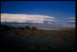
- Description:
- 25 f 9
- Subject:
- Panamint Mountains (Calif.), Deserts, Panamint Range (Calif.), Rocks, Rock formations, Mountains, and Clouds
- Series:
- 14-52
- Creator:
- Cushman, Charles W., 1896-1972
- Date Created:
- 1952-04-07
- Genre:
- Landscape photographs
- Frame Number:
- 14
- County:
- Inyo and San Bernardino
- Abstract:
- White cloud + distant Panamint Mtns. from few miles south of Trona.
- Call Number:
- P05998
- City:
- Trona
- Country:
- United States
- State/Province:
- California
- Physical Description:
- Image was originally mounted in a glass enclosure. Before digitization, the image was removed and placed in a Wess Plastic, Inc. brand, 2" x 2", pl...
- Alternate Identifier:
- 1452.14
- Persistent URL:
- http://purl.dlib.indiana.edu/iudl/archives/cushman/P05998
- Holding Location:
- Bloomington - University Archives
Wells Library E460
1320 E 10th St.
Bloomington, IN 47405
Contact at archives@indiana.edu, 812-855-1127
-
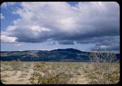
- Description:
- 25 f 11
- Subject:
- Deserts, Mojave Desert (Calif.), Shadows, Mountains, Shrubs, and Clouds
- Series:
- 14-52
- Creator:
- Cushman, Charles W., 1896-1972
- Date Created:
- 1952-04-07
- Genre:
- Landscape photographs
- Frame Number:
- 12
- Street Address:
- United States Highway 6
- County:
- Kern
- Abstract:
- Low dark mtn east of US 6. 10 mi. north of Ricardo.
- Call Number:
- P05996
- City:
- Ricardo
- Country:
- United States
- State/Province:
- California
- Alternate Identifier:
- 1452.12
- Persistent URL:
- http://purl.dlib.indiana.edu/iudl/archives/cushman/P05996
- Holding Location:
- Bloomington - University Archives
Wells Library E460
1320 E 10th St.
Bloomington, IN 47405
Contact at archives@indiana.edu, 812-855-1127
-
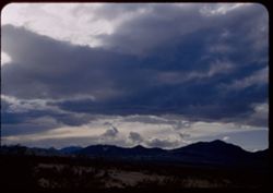
- Description:
- 25 f 8 Pola
- Subject:
- Mountains, Shrubs, Sierra Nevada (Calif. and Nev.), Shadows, and Clouds
- Series:
- 14-52
- Creator:
- Cushman, Charles W., 1896-1972
- Date Created:
- 1952-04-07
- Genre:
- Landscape photographs
- Frame Number:
- 13
- Street Address:
- Ridgecrest-Trona Road
- County:
- Kern and San Bernardino
- Abstract:
- Clouds + mtns in western sky from Ridgecrest-Trona road.
- Call Number:
- P05997
- City:
- Ridgecrest and Trona
- Country:
- United States
- State/Province:
- California
- Alternate Identifier:
- 1452.13
- Persistent URL:
- http://purl.dlib.indiana.edu/iudl/archives/cushman/P05997
- Holding Location:
- Bloomington - University Archives
Wells Library E460
1320 E 10th St.
Bloomington, IN 47405
Contact at archives@indiana.edu, 812-855-1127
-
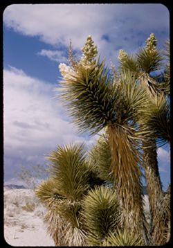
- Description:
- 25 f 11
- Subject:
- Deserts, Mojave Desert (Calif.), Sand, Flowers, Joshua trees, Tree limbs, Shrubs, and Clouds
- Series:
- 14-52
- Creator:
- Cushman, Charles W., 1896-1972
- Date Created:
- 1952-04-07
- Genre:
- Identification photographs
- Frame Number:
- 11
- County:
- Kern
- Abstract:
- Joshua tree near Ricardo.
- Call Number:
- P05995
- City:
- Ricardo
- Country:
- United States
- State/Province:
- California
- Alternate Identifier:
- 1452.11
- Persistent URL:
- http://purl.dlib.indiana.edu/iudl/archives/cushman/P05995
- Holding Location:
- Bloomington - University Archives
Wells Library E460
1320 E 10th St.
Bloomington, IN 47405
Contact at archives@indiana.edu, 812-855-1127
-
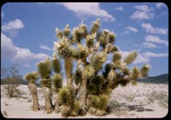
- Description:
- 25 f 11
- Subject:
- Deserts, Mojave Desert (Calif.), Sand, Trees, Joshua trees, Shrubs, Clouds, and Hills
- Series:
- 14-52
- Creator:
- Cushman, Charles W., 1896-1972
- Date Created:
- 1952-04-07
- Genre:
- Identification photographs
- Frame Number:
- 10
- Street Address:
- United States Highway 6
- County:
- Kern
- Abstract:
- Joshua tree near Ricardo.
- Call Number:
- P05994
- City:
- Ricardo
- Country:
- United States
- State/Province:
- California
- Alternate Identifier:
- 1452.10
- Persistent URL:
- http://purl.dlib.indiana.edu/iudl/archives/cushman/P05994
- Holding Location:
- Bloomington - University Archives
Wells Library E460
1320 E 10th St.
Bloomington, IN 47405
Contact at archives@indiana.edu, 812-855-1127
-
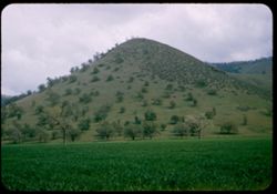
- Description:
- 25 f 9
- Subject:
- Croplands, Meadows, Tehachapi Pass (Calif.), Hills, Shrubs, Trees, Grasses, and Fences
- Series:
- 14-52
- Creator:
- Cushman, Charles W., 1896-1972
- Date Created:
- 1952-04-07
- Genre:
- Landscape photographs
- Frame Number:
- 9
- Street Address:
- United States Highway 466
- County:
- Kern
- Abstract:
- Peaked foothill between Bakersfield and Tehachapi.
- Call Number:
- P05993
- City:
- Tehachapi and Bakersfield
- Country:
- United States
- State/Province:
- California
- Alternate Identifier:
- 1452.9
- Persistent URL:
- http://purl.dlib.indiana.edu/iudl/archives/cushman/P05993
- Holding Location:
- Bloomington - University Archives
Wells Library E460
1320 E 10th St.
Bloomington, IN 47405
Contact at archives@indiana.edu, 812-855-1127
-
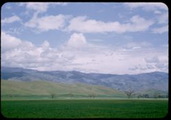
- Description:
- 25 f 11
- Subject:
- Grasses, Tehachapi Mountains (Calif.), Trees, Meadows, Croplands, Clouds, Hills, and Mountains
- Series:
- 14-52
- Creator:
- Cushman, Charles W., 1896-1972
- Date Created:
- 1952-04-07
- Genre:
- Landscape photographs
- Frame Number:
- 8
- Street Address:
- United States Highway 466
- County:
- Kern
- Abstract:
- Along Hwy 466 between Bakersfield and Tehachapi.
- Call Number:
- P05992
- City:
- Tehachapi and Bakersfield
- Country:
- United States
- State/Province:
- California
- Alternate Identifier:
- 1452.8
- Persistent URL:
- http://purl.dlib.indiana.edu/iudl/archives/cushman/P05992
- Holding Location:
- Bloomington - University Archives
Wells Library E460
1320 E 10th St.
Bloomington, IN 47405
Contact at archives@indiana.edu, 812-855-1127