
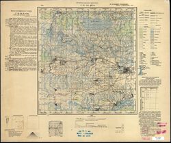
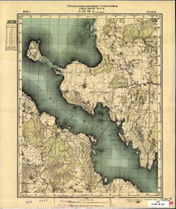
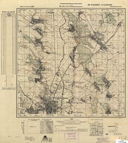
Search Constraints
You searched for:
Publisher
Управление военных топографов
Remove constraint Publisher: Управление военных топографов
« Previous |
1 - 50 of 465
|
Next »
Search Results
-
- Subject:
- Topical Subject: Maps, Geographic Subject: Lyuboml, and Topical Subject: Soviet Union
- Publisher:
- Управление военных топографов
- Language:
- Russian
- Date Created:
- 1891
- Identifier:
- VAC9619-000193
- Genre:
- Military Maps and Topographic Maps
- Geographic Location:
- Coordinates: 51.167, 24, 51.333, 24.25
- Related URL:
- Download GeoTIFF: https://drive.google.com/open?id=1w8ShRr1XZdo9wBCMn-f1ckMGagGqPeY0 and Catalog URL: http://iucat.iu.edu/catalog/5020131
- Abstract:
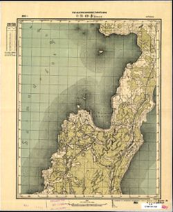
- Modern area represented: Lyuboml, Ukraine
- Call Number:
- G7000 s50 .S68 sheet M-35-25-A
- City:
- Любомль (Lyuboml)
- Copyright Holder:
- No Copyright - United States
- Country:
- Польша (Poland)
- Physical Description:
- Scale: 1:50,000
- Persistent URL:
- http://purl.dlib.indiana.edu/iudl/images/VAC9619/VAC9619-000193
- Provenance:
- DMA Topographic Center, Army Map Service Library, OMAHA
-
- Description:
- 1931
- Subject:
- Geographic Subject: Prigarovka, Topical Subject: Soviet Union, and Topical Subject: Maps
- Publisher:
- Управление военных топографов
- Language:
- Russian
- Date Created:
- 1932
- Identifier:
- VAC9619-001075
- Genre:
- Military Maps and Topographic Maps
- Geographic Location:
- Coordinates: 49, 33.75, 49.167, 34
- Related URL:
- Catalog URL: http://iucat.iu.edu/catalog/5020131 and Download GeoTIFF: https://drive.google.com/open?id=1f6wjuPrc3Ux9DrlosAXfFGB4gFxqmSmk
- Abstract:
- Modern area represented: Prigarovka, Poltava oblast, Ukraine
- Call Number:
- G7000 s50 .S68 М-36-104-Г
- Caption:
- Не подлежит оглашению
- City:
- Пригаривка (Prigarovka)
- Copyright Holder:
- No Copyright - United States
- Country:
- СССР (USSR)
- State/Province:
- Украинская ССР (Ukrainian Soviet Socialist Republic) and Харьковская область (Kharkiv oblast)
- Physical Description:
- Scale: 1:50,000
- Persistent URL:
- http://purl.dlib.indiana.edu/iudl/images/VAC9619/VAC9619-001075
- Provenance:
- DMA Topographic Center, Army Map Service Library, OMAHA, Library of Congress Geography & Map Division
-
- Description:
- 1891
- Subject:
- Topical Subject: Maps, Geographic Subject: St Petersburg, and Topical Subject: Soviet Union
- Publisher:
- Управление военных топографов
- Language:
- Russian
- Date Created:
- 1931
- Identifier:
- VAC9619-000897
- Genre:
- Military Maps and Topographic Maps
- Geographic Location:
- Coordinates: 59.8333, 30.25, 60, 30.5
- Related URL:
- Catalog URL: http://iucat.iu.edu/catalog/5020131 and Download GeoTIFF: https://drive.google.com/open?id=1FPa_YDmAVR2_-WZKluZAz2kowpTjWoSH
- Abstract:
- Modern area represented: St Petersburg, Russia
- Call Number:
- G7000 s50 .S68 sheet О-36-1-Б
- Caption:
- Не подлежит оглашению
- City:
- Ленинград (Leningrad)
- Copyright Holder:
- No Copyright - United States
- Country:
- СССР (USSR)
- State/Province:
- Ленинградская область (Leningrad oblast) and РСФСР (RSFSR)
- Physical Description:
- Scale: 1:50,000
- Persistent URL:
- http://purl.dlib.indiana.edu/iudl/images/VAC9619/VAC9619-000897
- Provenance:
- DMA Topographic Center, Army Map Service Library, OMAHA, Library of Congress Geography & Map Division
-
- Description:
- 1929
- Subject:
- Topical Subject: Soviet Union, Geographic Subject: Бабровічы (Babrovichy), and Topical Subject: Maps
- Publisher:
- Управление военных топографов
- Language:
- Russian
- Identifier:
- VAC9619-000829
- Genre:
- Military Maps and Topographic Maps
- Geographic Location:
- Coordinates: 52.167, 29.25, 52.333, 29.5
- Related URL:
- Download GeoTIFF: https://drive.google.com/open?id=138VirzeCDx88qbGqK4C2xzo0WKf9yBLV and Catalog URL: http://iucat.iu.edu/catalog/5020131
- Abstract:
- Modern area represented: Бабровічы (Babrovichy), Homyel' oblast, Belarus
- Call Number:
- g7000 s50 .S68 sheet N-35-143-B
- Caption:
- Не подлежит оглашению and Captured map
- City:
- Бобровичи (Bobrovichi)
- Copyright Holder:
- No Copyright - United States
- Country:
- СССР (USSR)
- State/Province:
- Белорусская ССР (Byelorussian Soviet Socialist Republic)
- Physical Description:
- Scale: 1:50,000
- Persistent URL:
- http://purl.dlib.indiana.edu/iudl/images/VAC9619/VAC9619-000829
- Provenance:
- Army Map Service Library, OMAHA, Library of Congress Geography & Map Division
-
- Subject:
- Geographic Subject: Mlyniv, Topical Subject: Soviet Union, and Topical Subject: Maps
- Publisher:
- Управление военных топографов
- Language:
- Russian
- Date Created:
- 1937
- Identifier:
- VAC9619-000218
- Genre:
- Military Maps and Topographic Maps
- Geographic Location:
- Coordinates: 50.5, 25.5, 50.667, 25.75
- Related URL:
- Download GeoTIFF: https://drive.google.com/open?id=13uyKeOnyHt_42-Dl3iUUZgFJz7RZ1yEB and Catalog URL: http://iucat.iu.edu/catalog/5020131
- Abstract:
- Modern area represented: Mlyniv, Ukraine
- Call Number:
- G7000 s50 .S68 sheet M-35-52-A
- City:
- Млынув (Mlynuv)
- Copyright Holder:
- No Copyright - United States
- Country:
- Польша (Poland)
- Physical Description:
- Scale: 1:50,000
- Persistent URL:
- http://purl.dlib.indiana.edu/iudl/images/VAC9619/VAC9619-000218
- Provenance:
- DMA Topographic Center, Army Map Service Library, OMAHA, Library of Congress Geography & Map Division
-
- Description:
- 1873
- Subject:
- Topical Subject: Soviet Union, Geographic Subject: Joniškis, and Topical Subject: Maps
- Publisher:
- Управление военных топографов
- Language:
- Russian
- Date Created:
- 1898
- Identifier:
- VAC9619-001766
- Genre:
- Topographic Maps and Military Maps
- Geographic Location:
- Coordinates: 56.167, 23.5, 56.333, 23.75
- Related URL:
- Catalog URL: http://iucat.iu.edu/catalog/5020131 and Download GeoTIFF: https://drive.google.com/open?id=1OdRsbGC2STlWvnO5t7Q5u04OLoHAWgjo
- Abstract:
- Modern area represented: Joniškis, Lithuania
- Call Number:
- G7000 s50 .S68 sheet O-34-144-A
- City:
- Янишки (Joniškis)
- Copyright Holder:
- No Copyright - United States
- Country:
- Литва (Lithuania)
- Physical Description:
- Scale: 1:50,000
- Persistent URL:
- http://purl.dlib.indiana.edu/iudl/images/VAC9619/VAC9619-001766
- Provenance:
- M. I. Map Library
-
- Description:
- 1932
- Subject:
- Topical Subject: Maps, Geographic Subject: Озаринці (Ozaryntsi), and Topical Subject: Soviet Union
- Publisher:
- Управление военных топографов
- Language:
- Russian
- Identifier:
- VAC9619-000885
- Genre:
- Topographic Maps and Military Maps
- Geographic Location:
- Coordinates: 48.5, 27.75, 48.6667, 28
- Related URL:
- Download GeoTIFF: https://drive.google.com/open?id=1clJyxxJUBFb2ek9BOTxSGPGM9AB6GFfx and Catalog URL: http://iucat.iu.edu/catalog/5020131
- Abstract:
- Modern area represented: Озаринці (Ozaryntsi), Vinnytsia Oblast, Ukraine
- Call Number:
- G7000 s50 .S68 sheet M-35-128-B
- Caption:
- Captured map and Не подлежит оглашению
- City:
- Озаринцы (Ozarintsy)
- Copyright Holder:
- No Copyright - United States
- Country:
- СССР (USSR)
- State/Province:
- Украинская ССР (Ukrainian Soviet Socialist Republic) and Винницкая область (Vinnytsia oblast)
- Physical Description:
- Scale: 1:50,000
- Persistent URL:
- http://purl.dlib.indiana.edu/iudl/images/VAC9619/VAC9619-000885
- Provenance:
- DMA Topographic Center, Army Map Service Library, OMAHA, Library of Congress Geography & Map Division
-
- Description:
- 1929
- Subject:
- Topical Subject: Soviet Union, Topical Subject: Maps, and Geographic Subject: Vasyutyntsi
- Publisher:
- Управление военных топографов
- Language:
- Russian
- Identifier:
- VAC9619-001034
- Genre:
- Topographic Maps and Military Maps
- Geographic Location:
- Coordinates: 49.3333, 32.25, 49.5, 32.5
- Related URL:
- Catalog URL: http://iucat.iu.edu/catalog/5020131 and Download GeoTIFF: https://drive.google.com/open?id=160E9TKQjJHKCc_oTkIq5sN78-OifQaYB
- Abstract:
- Modern area represented: Васютинці (Vasyutyntsi), Cherkasy oblast, Ukraine
- Call Number:
- G7000 s50 .S68 sheet M-36-89-D
- Caption:
- Не подлежит оглашению (crossed out) and Рассекречено
- City:
- Васютинцы (Vasyutintsy)
- Copyright Holder:
- No Copyright - United States
- Country:
- СССР (USSR)
- State/Province:
- Украинская ССР (Ukrainian Soviet Socialist Republic)
- Physical Description:
- Scale: 1:50,000
- Persistent URL:
- http://purl.dlib.indiana.edu/iudl/images/VAC9619/VAC9619-001034
- Provenance:
- DMA Topographic Center, Army Map Service Library, OMAHA, Library of Congress Geography & Map Division
-
- Description:
- 1932
- Subject:
- Topical Subject: Soviet Union, Topical Subject: Maps, and Geographic Subject: Parevichi
- Publisher:
- Управление военных топографов
- Language:
- Russian
- Date Created:
- 1935
- Identifier:
- VAC9619-003528
- Genre:
- Topographic Maps and Military Maps
- Geographic Location:
- Coordinates: 57.3333, 30.25, 57.5, 30.5
- Related URL:
- Download GeoTIFF: https://drive.google.com/file/d/1XoJ_B73bclp0wAy4LtwTrHbzPBWOIEMp/view?usp=sharing and Catalog URL: http://iucat.iu.edu/catalog/5020131
- Abstract:
- Modern area represented: Паревичи (Parevichi), Pskovskaya oblast, Russia
- Call Number:
- GM G7000 s50 .S68 sheet O-36-85-D
- Caption:
- Не подлежит оглашению
- City:
- Паревичи (Parevichi)
- Copyright Holder:
- No Copyright - United States
- Country:
- СССР (USSR)
- State/Province:
- Ленинградская область (Leningrad oblast) and РСФСР (RSFSR)
- Physical Description:
- Scale: 1:50,000
- Persistent URL:
- http://purl.dlib.indiana.edu/iudl/images/VAC9619/VAC9619-003528
- Provenance:
- Army Map Service Library, OMAHA, Library of Congress Geography & Map Division
-
- Description:
- 1931
- Subject:
- Geographic Subject: Радалівка, Topical Subject: Soviet Union, Geographic Subject: Radalivka, and Topical Subject: Maps
- Publisher:
- Управление военных топографов
- Language:
- Russian
- Identifier:
- VAC9619-001040
- Genre:
- Topographic Maps and Military Maps
- Geographic Location:
- Coordinates: 49.5, 33.25, 49.6667, 33.5
- Related URL:
- Download GeoTIFF: https://drive.google.com/open?id=1Enk3MnyFeez4uCvtZQPGS3OzXGkZjL06 and Catalog URL: http://iucat.iu.edu/catalog/5020131
- Abstract:
- Modern area represented: Радалівка (Radalivka), Poltava oblast, Ukraine
- Call Number:
- G7000 s50 .S68 sheet M-36-91-B
- Caption:
- Не подлежит оглашению
- City:
- Радоловка (Radolovka)
- Copyright Holder:
- No Copyright - United States
- Country:
- СССР (USSR)
- State/Province:
- Украинская ССР (Ukrainian Soviet Socialist Republic)
- Physical Description:
- Scale: 1:50,000
- Persistent URL:
- http://purl.dlib.indiana.edu/iudl/images/VAC9619/VAC9619-001040
- Provenance:
- DMA Topographic Center, Army Map Service Library, OMAHA, Library of Congress Geography & Map Division
-
- Description:
- 1928
- Subject:
- Topical Subject: Maps, Topical Subject: Soviet Union, and Geographic Subject: Studenyky
- Publisher:
- Управление военных топографов
- Language:
- Russian
- Identifier:
- VAC9619-000978
- Genre:
- Military Maps and Topographic Maps
- Geographic Location:
- Coordinates: 50.167, 31.5, 50.333, 31.75
- Related URL:
- Download GeoTIFF: https://drive.google.com/open?id=1mFkjs4ZwqSZ_EiIAg_830EoD5IaKv275 and Catalog URL: http://iucat.iu.edu/catalog/5020131
- Abstract:
- Modern area represented: Студеники (Studenyky), Kyiv oblast, Ukraine
- Call Number:
- G7000 s50 .S68 sheet M-36-64-A
- Caption:
- Не подлежит оглашению
- City:
- Студеники (Studeniki)
- Copyright Holder:
- No Copyright - United States
- Country:
- СССР (USSR)
- State/Province:
- Украинская ССР (Ukrainian Soviet Socialist Republic)
- Physical Description:
- Scale: 1:50,000
- Persistent URL:
- http://purl.dlib.indiana.edu/iudl/images/VAC9619/VAC9619-000978
- Provenance:
- DMA Topographic Center, Army Map Service Library, Library of Congress Geography & Map Division
-
- Description:
- 1896
- Subject:
- Topical Subject: Maps, Topical Subject: Soviet Union, and Geographic Subject: Mažeikiai
- Publisher:
- Управление военных топографов
- Language:
- Russian
- Date Created:
- 1897
- Identifier:
- VAC9619-001764
- Genre:
- Topographic Maps and Military Maps
- Geographic Location:
- Coordinates: 56, 23, 56.167, 23.25
- Related URL:
- Catalog URL: http://iucat.iu.edu/catalog/5020131 and Download GeoTIFF: https://drive.google.com/open?id=1UzmO7gBvQAKv4GTAk8ecuNHfpnVwNalA
- Abstract:
- Modern area represented: Mažeikiai, Lithuania
- Call Number:
- G7000 s50 .S68 sheet O-34-143-C
- City:
- Можейки (Mažeikiai)
- Copyright Holder:
- No Copyright - United States
- Country:
- Литва (Lithuania)
- Physical Description:
- Scale: 1:50,000
- Persistent URL:
- http://purl.dlib.indiana.edu/iudl/images/VAC9619/VAC9619-001764
- Provenance:
- M. I. Map Library
-
- Description:
- 1928
- Subject:
- Geographic Subject: Борзна (Borzna), Topical Subject: Maps, and Topical Subject: Soviet Union
- Publisher:
- Управление военных топографов
- Language:
- Russian
- Identifier:
- VAC9619-000936
- Genre:
- Military Maps and Topographic Maps
- Geographic Location:
- Coordinates: 51.167, 32.25, 51.333, 32.5
- Related URL:
- Download GeoTIFF: https://drive.google.com/open?id=18xhNg6LcpIBkHFZKIxvC99q6RO41c9kY and Catalog URL: http://iucat.iu.edu/catalog/5020131
- Abstract:
- Modern area represented: Борзна (Borzna), Chernihiv oblast, Ukraine
- Call Number:
- G7000 s50 .S68 sheet M-36-27-B
- Caption:
- Не подлежит оглашению
- City:
- Борзна (Borzna)
- Copyright Holder:
- No Copyright - United States
- Country:
- СССР (USSR)
- State/Province:
- Украинская ССР (Ukrainian Soviet Socialist Republic)
- Physical Description:
- Scale: 1:50,000
- Persistent URL:
- http://purl.dlib.indiana.edu/iudl/images/VAC9619/VAC9619-000936
- Provenance:
- DMA Topographic Center, Army Map Service Library, OMAHA, Library of Congress Geography & Map Division
-
- Description:
- 1932
- Subject:
- Topical Subject: Soviet Union, Topical Subject: Maps, and Geographic Subject: Zapolye
- Publisher:
- Управление военных топографов
- Language:
- Russian
- Identifier:
- VAC9619-000056
- Genre:
- Topographic Maps and Military Maps
- Geographic Location:
- Coordinates: 57.3333, 30.5, 57.5, 30.75
- Related URL:
- Download GeoTIFF: https://drive.google.com/open?id=17_x28_Z_BDVfOkrBbY4QTkM7htZCIsu8 and Catalog URL: http://iucat.iu.edu/catalog/5020131
- Abstract:
- Modern area represented: Zapolye, Novgorod oblast, Russia
- Call Number:
- G7000 s50 .S68 sheet O-36-86-C
- Caption:
- Не подлежит оглашению
- City:
- Заполье (Zapolye)
- Copyright Holder:
- No Copyright - United States
- Country:
- СССР (USSR)
- State/Province:
- Ленинградская область (Leningrad oblast) and РСФСР (RSFSR)
- Physical Description:
- Scale: 1:50,000
- Persistent URL:
- http://purl.dlib.indiana.edu/iudl/images/VAC9619/VAC9619-000056
- Provenance:
- DMA Topographic Center, Army Map Service Library, OMAHA, Library of Congress Geography & Map Division
-
- Subject:
- Topical Subject: Soviet Union, Topical Subject: Maps, and Geographic Subject: Holoby
- Publisher:
- Управление военных топографов
- Language:
- Russian
- Identifier:
- VAC9619-000202
- Genre:
- Military Maps and Topographic Maps
- Geographic Location:
- Coordinates: 51, 25, 51.167, 25.25
- Related URL:
- Download GeoTIFF: https://drive.google.com/open?id=1adw_ENZ7am6VKEQzlA9qtW5NtHq3Iljx and Catalog URL: http://iucat.iu.edu/catalog/5020131
- Abstract:
- Modern area represented: Holoby, Volyn oblast, Ukraine
- Call Number:
- G7000 s50 .S68 sheet M-35-27-C
- City:
- Голобы (Hołoby)
- Copyright Holder:
- No Copyright - United States
- Country:
- Польша (Poland)
- Physical Description:
- Scale: 1:50,000
- Persistent URL:
- http://purl.dlib.indiana.edu/iudl/images/VAC9619/VAC9619-000202
- Provenance:
- DMA Topographic Center, Army Map Service Library, Library of Congress Geography & Map Division, OMAHA
-
- Description:
- 1923
- Subject:
- Topical Subject: Soviet Union, Geographic Subject: Lyëzna, and Topical Subject: Maps
- Publisher:
- Управление военных топографов
- Language:
- Russian
- Date Created:
- 1929
- Identifier:
- VAC9619-001259
- Genre:
- Military Maps and Topographic Maps
- Geographic Location:
- Coordinates: 55, 30.75, 55.167, 31
- Related URL:
- Catalog URL: http://iucat.iu.edu/catalog/5020131 and Download GeoTIFF: https://drive.google.com/open?id=1wwJUum2HZbDty6oLkHIQqNQllsH-yzXj
- Abstract:
- Modern area represented: Lyëzna, Vitebsk oblast, Belarus
- Call Number:
- GM G7000 S50 .S68 N-36-26-D
- Caption:
- Не подлежит оглашению
- City:
- Лиозно (Lyëzna)
- Copyright Holder:
- No Copyright - United States
- Country:
- СССР (USSR)
- State/Province:
- РСФСР (RSFSR), Западная область (Western oblast), and Белорусская ССР (Byelorussian Soviet Socialist Republic)
- Physical Description:
- Scale: 1:50,000
- Persistent URL:
- http://purl.dlib.indiana.edu/iudl/images/VAC9619/VAC9619-001259
- Provenance:
- Army Map Service Library, Library of Congress Geography & Map Division, OMAHA
-
- Description:
- 1931
- Subject:
- Geographic Subject: Lyudzyanyevichy, Topical Subject: Soviet Union, and Topical Subject: Maps
- Publisher:
- Управление военных топографов
- Language:
- Russian
- Identifier:
- VAC9619-000805
- Genre:
- Military Maps and Topographic Maps
- Geographic Location:
- Coordinates: 52.167, 27.5, 52.333, 27.75
- Related URL:
- Download GeoTIFF: https://drive.google.com/open?id=1Iz6igjqfubylUvJDRkPnaNLvnw66JNjs and Catalog URL: http://iucat.iu.edu/catalog/5020131
- Abstract:
- Modern area represented: Lyudzyanyevichy, Homyel oblast, Belarus
- Call Number:
- G7000 s50 .s68 sheet N-35-140-A
- Caption:
- Не подлежит оглашению
- City:
- Люденевичи (Lyudenevichi)
- Copyright Holder:
- No Copyright - United States
- Country:
- Польша (Poland) and СССР (USSR)
- State/Province:
- Белорусская ССР (Byelorussian Soviet Socialist Republic)
- Physical Description:
- Scale: 1:50,000
- Persistent URL:
- http://purl.dlib.indiana.edu/iudl/images/VAC9619/VAC9619-000805
- Provenance:
- DMA Topographic Center, Army Map Service Library, OMAHA, Library of Congress Geography & Map Division
-
- Description:
- 1891
- Subject:
- Topical Subject: Maps, Geographic Subject: Lopukhinka, and Topical Subject: Soviet Union
- Publisher:
- Управление военных топографов
- Language:
- Russian
- Date Created:
- 1930
- Identifier:
- VAC9619-001778
- Genre:
- Topographic Maps and Military Maps
- Geographic Location:
- Coordinates: 59.667, 29.25, 59.833, 29.5
- Related URL:
- Catalog URL: http://iucat.iu.edu/catalog/5020131 and Download GeoTIFF: https://drive.google.com/open?id=1ZRH4l3tn8j7xBdShk0pD3V3dk8MFcq7H
- Abstract:
- Modern area represented: Lopukhinka, Leningrad oblast, Russia
- Call Number:
- G7000 s50 .S68 sheet O-35-11-Г
- Caption:
- Не подлежит оглашению
- City:
- Лопухинка (Lopukhinka)
- Copyright Holder:
- No Copyright - United States
- Country:
- СССР (USSR)
- State/Province:
- РСФСР (RSFSR) and Ленинградская область (Leningrad oblast)
- Physical Description:
- Scale: 1:50,000
- Persistent URL:
- http://purl.dlib.indiana.edu/iudl/images/VAC9619/VAC9619-001778
- Provenance:
- Army Map Service Library, Library of Congress Geography & Map Division, OMAHA
-
- Description:
- 1929
- Subject:
- Geographic Subject: Якімавічы (Yakimavichy), Topical Subject: Soviet Union, and Topical Subject: Maps
- Publisher:
- Управление военных топографов
- Language:
- Russian
- Identifier:
- VAC9619-000828
- Genre:
- Military Maps and Topographic Maps
- Geographic Location:
- Coordinates: 52.167, 29, 52.333, 29.25
- Related URL:
- Catalog URL: http://iucat.iu.edu/catalog/5020131 and Download GeoTIFF: https://drive.google.com/open?id=1hW0JVK_txFGDjpfXu8G4PvC7QH-R8TTL
- Abstract:
- Modern area represented: Якімавічы (Yakimavichy), Homyel' oblast, Belarus
- Call Number:
- g7000 s50 .S68 sheet N-35-143-A
- Caption:
- Не подлежит оглашению
- City:
- Якимовичи (Yakimovichi)
- Copyright Holder:
- No Copyright - United States
- Country:
- СССР (USSR)
- State/Province:
- Белорусская ССР (Byelorussian Soviet Socialist Republic)
- Physical Description:
- Scale: 1:50,000
- Persistent URL:
- http://purl.dlib.indiana.edu/iudl/images/VAC9619/VAC9619-000828
- Provenance:
- Army Map Service Library, OMAHA, Library of Congress Geography & Map Division
-
- Subject:
- Topical Subject: Maps, Topical Subject: Soviet Union, and Geographic Subject: Şıxzahırlı
- Publisher:
- Управление военных топографов
- Language:
- Russian
- Identifier:
- VAC9619-000102
- Genre:
- Topographic Maps and Military Maps
- Geographic Location:
- Coordinates: 40.3333, 49, 40.5, 49.25
- Related URL:
- Catalog URL: http://iucat.iu.edu/catalog/5020131 and Download GeoTIFF: https://drive.google.com/open?id=1whAXNIk9XmsAjVmpnbtT68C6DFI6K3M5
- Abstract:
- Modern area represented: Şıxzahırlı, Azerbaijan
- Call Number:
- G7000 s50 .S68 sheet K-39-123-C
- Caption:
- Не подлежит оглашению
- City:
- Ших-Загирли (Shikh-Zagirli)
- Copyright Holder:
- No Copyright - United States
- Country:
- СССР (USSR)
- State/Province:
- Азербайджанская ССР (Azerbaijan Soviet Socialist Republic)
- Physical Description:
- Scale: 1:50,000
- Persistent URL:
- http://purl.dlib.indiana.edu/iudl/images/VAC9619/VAC9619-000102
- Provenance:
- DMA Topographic Center, Army Map Service Library, OMAHA, Library of Congress Geography & Map Division
-
- Description:
- 1931
- Subject:
- Geographic Subject: Тураў (Turow), Topical Subject: Soviet Union, and Topical Subject: Maps
- Publisher:
- Управление военных топографов
- Language:
- Russian
- Identifier:
- VAC9619-000807
- Genre:
- Military Maps and Topographic Maps
- Geographic Location:
- Coordinates: 52, 27.5, 52.167, 27.75
- Related URL:
- Catalog URL: http://iucat.iu.edu/catalog/5020131 and Download GeoTIFF: https://drive.google.com/open?id=1XSod-am5pw3wlcn9E8g_3g3WtxOdNnyD
- Abstract:
- Modern area represented: Тураў (Turow), Homyel' oblast, Belarus
- Call Number:
- G7000 s50 .s68 sheet N-35-140-C
- Caption:
- Не подлежит оглашению
- City:
- Туров (Turov)
- Copyright Holder:
- No Copyright - United States
- Country:
- Польша (Poland) and СССР (USSR)
- State/Province:
- Белорусская ССР (Byelorussian Soviet Socialist Republic)
- Physical Description:
- Scale: 1:50,000
- Persistent URL:
- http://purl.dlib.indiana.edu/iudl/images/VAC9619/VAC9619-000807
- Provenance:
- M. I. Map Library
-
- Description:
- 1929
- Subject:
- Topical Subject: Maps, Geographic Subject: Калинкавичы (Kalinkavichy), and Topical Subject: Soviet Union
- Publisher:
- Управление военных топографов
- Language:
- Russian
- Identifier:
- VAC9619-000830
- Genre:
- Military Maps and Topographic Maps
- Geographic Location:
- Coordinates: 52.0, 29.25, 52.16667, 29.5
- Related URL:
- Download GeoTIFF: https://drive.google.com/open?id=1nb3LExZESDZr6-VZkFqWAOPiKKhs5k7X and Catalog URL: http://iucat.iu.edu/catalog/5020131
- Abstract:
- Modern area represented: Калинкавичы (Kalinkavichy), Homyel' oblast, Belarus
- Call Number:
- G7000 s50 .S68 sheet N-35-143-D
- Caption:
- Не подлежит оглашению
- City:
- Калинковичи (Kalinkovichi)
- Copyright Holder:
- No Copyright - United States
- Country:
- СССР (USSR)
- State/Province:
- Белорусская ССР (Byelorussian Soviet Socialist Republic)
- Physical Description:
- Scale: 1:50,000
- Persistent URL:
- http://purl.dlib.indiana.edu/iudl/images/VAC9619/VAC9619-000830
- Provenance:
- Army Map Service Library, OMAHA, Library of Congress Geography & Map Division
-
- Description:
- 1903
- Subject:
- Geographic Subject: Olgina, Topical Subject: Maps, and Topical Subject: Soviet Union
- Publisher:
- Управление военных топографов
- Language:
- Russian
- Identifier:
- VAC9619-001698
- Genre:
- Military Maps and Topographic Maps
- Geographic Location:
- Coordinates: 58.5, 22.5, 58.667, 22.75
- Related URL:
- Catalog URL: http://iucat.iu.edu/catalog/5020131 and Download GeoTIFF: https://drive.google.com/open?id=1rgBwmA1B25Zp0e6VvKGO3Dbg0vq2ayfI
- Abstract:
- Modern area represented: Olgina, Ida-Viru county, Estonia
- Call Number:
- G7000 s50 .S68 sheet O-34-58-A
- City:
- Ольгино (Olgina)
- Copyright Holder:
- No Copyright - United States
- Country:
- Эстония (Estonia)
- Physical Description:
- Scale: 1:50,000
- Persistent URL:
- http://purl.dlib.indiana.edu/iudl/images/VAC9619/VAC9619-001698
- Provenance:
- Army Map Service Library, Library of Congress Geography & Map Division, OMAHA
-
- Description:
- 1927
- Subject:
- Topical Subject: Soviet Union, Geographic Subject: Kovali, and Topical Subject: Maps
- Publisher:
- Управление военных топографов
- Language:
- Russian
- Identifier:
- VAC9619-003494
- Genre:
- Topographic Maps and Military Maps
- Geographic Location:
- Coordinates: 56.0, 31.75, 56.16667, 32.0
- Related URL:
- Download GeoTIFF: https://drive.google.com/file/d/1aUs01744U8z9WJUyVwJHJ7uEfI1G5EIX/view?usp=sharing and Catalog URL: http://iucat.iu.edu/catalog/5020131
- Abstract:
- Modern area represented: Ковали (Kovali), Tverskaya oblast, Russia
- Call Number:
- G7000 s50 .S68 sheet O-36-136-D
- Caption:
- Не подлежит оглашению
- City:
- Ковали (Kovali)
- Copyright Holder:
- No Copyright - United States
- Country:
- СССР (USSR)
- State/Province:
- РСФСР (RSFSR) and Западная область (Western oblast)
- Physical Description:
- Scale: 1:50,000
- Persistent URL:
- http://purl.dlib.indiana.edu/iudl/images/VAC9619/VAC9619-003494
- Provenance:
- M. I. Map Library
-
- Description:
- 1929
- Subject:
- Geographic Subject: Moshny, Topical Subject: Soviet Union, and Topical Subject: Maps
- Publisher:
- Управление военных топографов
- Language:
- Russian
- Date Created:
- 1932
- Identifier:
- VAC9619-001027
- Genre:
- Military Maps and Topographic Maps
- Geographic Location:
- Coordinates: 49.5, 31.5, 49.6667, 31.75
- Related URL:
- Catalog URL: http://iucat.iu.edu/catalog/5020131 and Download GeoTIFF: https://drive.google.com/open?id=1YDdnSgfHB6iMpwwVJPx9zoDfBiEx-g7S
- Abstract:
- Modern area represented: Мошни (Moshny), Cherkasy oblast, Ukraine
- Call Number:
- G7000 s50 .S68 sheet M-36-88-A
- Caption:
- Рассекречено and Не подлежит оглашению
- City:
- Мошны (Moshny)
- Copyright Holder:
- No Copyright - United States
- Country:
- СССР (USSR)
- State/Province:
- Украинская ССР (Ukrainian Soviet Socialist Republic)
- Physical Description:
- Scale: 1:50,000
- Persistent URL:
- http://purl.dlib.indiana.edu/iudl/images/VAC9619/VAC9619-001027
- Provenance:
- M. I. Map Library, Library of Congress Geography & Map Division
-
- Description:
- 1928
- Subject:
- Topical Subject: Maps, Geographic Subject: Nosivka, and Topical Subject: Soviet Union
- Publisher:
- Управление военных топографов
- Language:
- Russian
- Identifier:
- VAC9619-000945
- Genre:
- Topographic Maps and Military Maps
- Geographic Location:
- Coordinates: 50.83333, 31.5, 51.0, 31.75
- Related URL:
- Download GeoTIFF: https://drive.google.com/open?id=1HU1BEWPgZ8qd6bHAah_zz9Gs1-CumXii and Catalog URL: http://iucat.iu.edu/catalog/5020131
- Abstract:
- Modern area represented: Nosivka, Chernihiv oblast, Ukraine
- Call Number:
- G7000 s50 .S68 sheet M-36-40-A
- Caption:
- Не подлежит оглашению
- City:
- Носовка (Nosovka)
- Copyright Holder:
- No Copyright - United States
- Country:
- СССР (USSR)
- State/Province:
- Украинская ССР (Ukrainian Soviet Socialist Republic)
- Physical Description:
- Scale: 1:50,000
- Persistent URL:
- http://purl.dlib.indiana.edu/iudl/images/VAC9619/VAC9619-000945
- Provenance:
- DMA Topographic Center, Army Map Service Library, Library of Congress Geography & Map Division
-
- Description:
- 1904
- Subject:
- Topical Subject: Soviet Union, Topical Subject: Maps, and Geographic Subject: Stepan
- Publisher:
- Управление военных топографов
- Language:
- Russian
- Identifier:
- VAC9619-000207
- Genre:
- Military Maps and Topographic Maps
- Geographic Location:
- Coordinates: 51, 26.25, 51.167, 26.5
- Related URL:
- Download GeoTIFF: https://drive.google.com/open?id=1bTwttJKED6XJW9TmdPkYHDE5HlwYpswi and Catalog URL: http://iucat.iu.edu/catalog/5020131
- Abstract:
- Modern area represented: Stepan, Rivne oblast, Ukraine
- Call Number:
- G7000 s50 .S68 sheet M-35-29-D
- City:
- Степань (Stepań)
- Copyright Holder:
- No Copyright - United States
- Country:
- Польша (Poland)
- Physical Description:
- Scale: 1:50,000
- Persistent URL:
- http://purl.dlib.indiana.edu/iudl/images/VAC9619/VAC9619-000207
- Provenance:
- M. I. Map Library, G000-30
-
- Description:
- 1921
- Subject:
- Topical Subject: Soviet Union, Topical Subject: Maps, and Geographic Subject: Великі Копані (Velyki Kopani)
- Publisher:
- Управление военных топографов
- Language:
- Russian
- Date Created:
- 1933
- Identifier:
- VAC9619-000122
- Genre:
- Military Maps and Topographic Maps
- Geographic Location:
- Coordinates: 46.3333, 32.75, 46.5, 33
- Related URL:
- https://drive.google.com/open?id=1YVaxNwv9dRB21t0pKObSeHn__dPVCw7l, Download GeoTIFF: https://drive.google.com/open?id=1PpCBrQtUKhwRBcPpZgQf3aNkYSHRD9F5, and...
- Abstract:
- Modern area represented: Velyki Kopani, Kherson oblast, Ukraine
- Call Number:
- G7000 s50 .S68 sheet L-36-54-D
- Caption:
- Не подлежит оглашению,Секретно
- City:
- Большие Копани (Bolshiye Kopani)
- Copyright Holder:
- No Copyright - United States
- Country:
- СССР (USSR)
- State/Province:
- Украинская ССР (Ukrainian Soviet Socialist Republic)
- Physical Description:
- Scale: 1:50,000
- Persistent URL:
- http://purl.dlib.indiana.edu/iudl/images/VAC9619/VAC9619-000122
- Provenance:
- DMA Topographic Center, Army Map Service Library, OMAHA
-
- Subject:
- Topical Subject: Maps, Topical Subject: Soviet Union, and Geographic Subject: Pavoloch
- Publisher:
- Управление военных топографов
- Language:
- Russian
- Identifier:
- VAC9619-000848
- Genre:
- Military Maps and Topographic Maps
- Geographic Location:
- Coordinates: 49.8333, 29.25, 50, 29.5
- Related URL:
- Download GeoTIFF: https://drive.google.com/open?id=1rClY9QwrPg534wZKiLiyAW-wSoq55sEd and Catalog URL: http://iucat.iu.edu/catalog/5020131
- Abstract:
- Modern area represented: Pavoloch, Zhytomyr oblast, Ukraine
- Call Number:
- G7000 s50 .S68 sheet M-35-83-B
- Caption:
- Не подлежит оглашению
- City:
- Паволочь (Pavoloch)
- Copyright Holder:
- No Copyright - United States
- Country:
- СССР (USSR)
- State/Province:
- Украинская ССР (Ukrainian Soviet Socialist Republic) and Киевская область (Kyiv oblast)
- Physical Description:
- Scale: 1:50,000
- Persistent URL:
- http://purl.dlib.indiana.edu/iudl/images/VAC9619/VAC9619-000848
- Provenance:
- CIA Map Branch -- Received
-
- Description:
- 1929
- Subject:
- Geographic Subject: Azarychy, Topical Subject: Maps, and Topical Subject: Soviet Union
- Publisher:
- Управление военных топографов
- Language:
- Russian
- Identifier:
- VAC9619-000790
- Genre:
- Military Maps and Topographic Maps
- Geographic Location:
- Coordinates: 52.333, 29.25, 52.5, 29.5
- Related URL:
- Download GeoTIFF: https://drive.google.com/open?id=1Uqe7-WXNazdS1P1xaQVm59gXsGcZNwg- and Catalog URL: http://iucat.iu.edu/catalog/5020131
- Abstract:
- Modern area represented: Azarychy, Homyel oblast, Belarus
- Call Number:
- G7000 s50 .s68 sheet N-35-131-D
- Caption:
- Не подлежит оглашению
- City:
- Озаричи (Ozarichi)
- Copyright Holder:
- No Copyright - United States
- Country:
- СССР (USSR)
- State/Province:
- Белорусская ССР (Byelorussian Soviet Socialist Republic)
- Physical Description:
- Scale: 1:50,000
- Persistent URL:
- http://purl.dlib.indiana.edu/iudl/images/VAC9619/VAC9619-000790
- Provenance:
- CIA Map Branch -- Received
-
- Description:
- 1900
- Subject:
- Topical Subject: Maps, Geographic Subject: Nurste, and Topical Subject: Soviet Union
- Publisher:
- Управление военных топографов
- Language:
- Russian
- Identifier:
- VAC9619-001676
- Genre:
- Military Maps and Topographic Maps
- Geographic Location:
- Coordinates: 58.667, 22.25, 58.833, 22.5
- Related URL:
- Download GeoTIFF: https://drive.google.com/open?id=1m91JPw35pvoO7zI0BurSZl5Jn1rjRURH and Catalog URL: http://iucat.iu.edu/catalog/5020131
- Abstract:
- Modern area represented: Nurste, Hiiumaa county, Estonia
- Call Number:
- G7000 s50 .S68 sheet O-34-45-Г
- City:
- Нурсте (Nurste)
- Copyright Holder:
- No Copyright - United States
- Country:
- Эстония (Estonia)
- Physical Description:
- Scale: 1:50,000
- Persistent URL:
- http://purl.dlib.indiana.edu/iudl/images/VAC9619/VAC9619-001676
- Provenance:
- Army Map Service Library, OMAHA
-
- Description:
- 1909
- Subject:
- Topical Subject: Soviet Union, Topical Subject: Maps, and Geographic Subject: Horodets
- Publisher:
- Управление военных топографов
- Language:
- Russian
- Identifier:
- VAC9619-000205
- Genre:
- Topographic Maps and Military Maps
- Geographic Location:
- Coordinates: 51.167, 26.25, 51.333, 26.5
- Related URL:
- Download GeoTIFF: https://drive.google.com/open?id=1tx_3wEalMcWWEu9yHQWgaoe6iOcYVQAt and Catalog URL: http://iucat.iu.edu/catalog/5020131
- Abstract:
- Modern area represented: Horodets, Rivne oblast, Ukraine
- Call Number:
- G7000 s50 .S68 sheet M-35-29-B
- City:
- Городец (Horodziec)
- Copyright Holder:
- No Copyright - United States
- Country:
- Польша (Poland)
- Physical Description:
- Scale: 1:50,000
- Persistent URL:
- http://purl.dlib.indiana.edu/iudl/images/VAC9619/VAC9619-000205
- Provenance:
- CIA Map Branch -- Received, FEM Austria
-
- Description:
- 1900
- Subject:
- Geographic Subject: Jausa, Topical Subject: Soviet Union, and Topical Subject: Maps
- Publisher:
- Управление военных топографов
- Language:
- Russian
- Identifier:
- VAC9619-001680
- Genre:
- Topographic Maps and Military Maps
- Geographic Location:
- Coordinates: 58.667, 22.5, 58.833, 22.75
- Related URL:
- Catalog URL: http://iucat.iu.edu/catalog/5020131 and Download GeoTIFF: https://drive.google.com/open?id=1iXG1lS7-Lqd7d4zH3KQUtofqmtG3KL74
- Abstract:
- Modern area represented: Jausa, Hiiumaa county, Estonia
- Call Number:
- G7000 s50 .S68 sheet O-34-46-C
- City:
- Яусте (Jausa)
- Copyright Holder:
- No Copyright - United States
- Country:
- Эстония (Estonia)
- Physical Description:
- Scale: 1:50,000
- Persistent URL:
- http://purl.dlib.indiana.edu/iudl/images/VAC9619/VAC9619-001680
- Provenance:
- Army Map Service Library, Library of Congress Geography & Map Division, OMAHA
-
- Description:
- 1928
- Subject:
- Geographic Subject: Monastyryshche, Topical Subject: Soviet Union, and Topical Subject: Maps
- Publisher:
- Управление военных топографов
- Language:
- Russian
- Date Created:
- 1934
- Identifier:
- VAC9619-000950
- Genre:
- Topographic Maps and Military Maps
- Geographic Location:
- Coordinates: 50.66667, 32.0, 50.83333, 32.25
- Related URL:
- Download GeoTIFF: https://drive.google.com/open?id=1osXpm-MYY-r77zS8l33PrM8YxdBG8aOy and Catalog URL: http://iucat.iu.edu/catalog/5020131
- Abstract:
- Modern area represented: Monastyryshche, Chernihiv oblast, Ukraine
- Call Number:
- G7000 s50 .S68 sheet M-36-41-B
- Caption:
- Не подлежит оглашению
- City:
- Монастырище (Monastyrishche)
- Copyright Holder:
- No Copyright - United States
- Country:
- СССР (USSR)
- State/Province:
- Украинская ССР (Ukrainian Soviet Socialist Republic)
- Physical Description:
- Scale: 1:50,000
- Persistent URL:
- http://purl.dlib.indiana.edu/iudl/images/VAC9619/VAC9619-000950
- Provenance:
- DMA Topographic Center, Army Map Service Library, OMAHA, Library of Congress Geography & Map Division
-
- Description:
- 1932
- Subject:
- Topical Subject: Soviet Union, Topical Subject: Maps, and Geographic Subject: Sosnitsa
- Publisher:
- Управление военных топографов
- Language:
- Russian
- Identifier:
- VAC9619-003527
- Genre:
- Topographic Maps and Military Maps
- Geographic Location:
- Coordinates: 57.5, 30.25, 57.66667, 30.5
- Related URL:
- Download GeoTIFF: https://drive.google.com/file/d/1otfh7tEJGovjTG1kBgOUSPykGF2A9kj3/view?usp=sharing and Catalog URL: http://iucat.iu.edu/catalog/5020131
- Abstract:
- Modern area represented: Сосница (Sosnitsa), Pskovskaya oblast, Russia
- Call Number:
- GM G7000 s50 .S68 sheet O-36-85-B
- Caption:
- Не подлежит оглашению and Captured map
- City:
- Сосницы (Sosnitsy)
- Copyright Holder:
- No Copyright - United States
- Country:
- СССР (USSR)
- State/Province:
- Ленинградская область (Leningrad oblast) and РСФСР (RSFSR)
- Physical Description:
- Scale: 1:50,000
- Persistent URL:
- http://purl.dlib.indiana.edu/iudl/images/VAC9619/VAC9619-003527
- Provenance:
- Army Map Service Library, OMAHA
-
- Description:
- 1939
- Subject:
- Topical Subject: Soviet Union, Geographic Subject: Vorobyevo, and Topical Subject: Maps
- Publisher:
- Управление военных топографов
- Language:
- Russian
- Identifier:
- VAC9619-001284
- Genre:
- Military Maps and Topographic Maps
- Geographic Location:
- Coordinates: 55.1667, 34.75, 55.3333, 35
- Related URL:
- Download GeoTIFF: https://drive.google.com/open?id=1LayhulUP8SrFFvp-1eSPl0T8NZqOu58p and Catalog URL: http://iucat.iu.edu/catalog/5020131
- Abstract:
- Modern area represented: Vorobyevo, Smolensk oblast, Russia
- Call Number:
- GM G7000 S50 .S68 N-36-34-Б
- City:
- Воробьево (Vorobyevo)
- Copyright Holder:
- No Copyright - United States
- Country:
- СССР (USSR)
- State/Province:
- РСФСР (RSFSR) and Смоленская область (Smolensk oblast)
- Physical Description:
- Scale: 1:50,000
- Persistent URL:
- http://purl.dlib.indiana.edu/iudl/images/VAC9619/VAC9619-001284
- Provenance:
- DMA Topographic Center, Army Map Service Library, Library of Congress Geography & Map Division
-
- Description:
- 1931
- Subject:
- Topical Subject: Maps, Geographic Subject: Deriyivka, and Topical Subject: Soviet Union
- Publisher:
- Управление военных топографов
- Language:
- Russian
- Date Created:
- 1932
- Identifier:
- VAC9619-001096
- Genre:
- Topographic Maps and Military Maps
- Geographic Location:
- Coordinates: 48.833, 33.75, 49, 34
- Related URL:
- Catalog URL: http://iucat.iu.edu/catalog/5020131 and Download GeoTIFF: https://drive.google.com/open?id=1LN7i_LoBas4-BCPYShFOW-PILcYQ7657
- Abstract:
- Modern area represented: Deriyivka, Kirovohrad oblast, Ukraine
- Call Number:
- G7000 s50 .S68 М-36-116-Б
- Caption:
- Не подлежит оглашению
- City:
- Дериевка (Deriyivka)
- Copyright Holder:
- No Copyright - United States
- Country:
- СССР (USSR)
- State/Province:
- Киевская область (Kyiv oblast) and Украинская ССР (Ukrainian Soviet Socialist Republic)
- Physical Description:
- Scale: 1:50,000
- Persistent URL:
- http://purl.dlib.indiana.edu/iudl/images/VAC9619/VAC9619-001096
- Provenance:
- DMA Topographic Center, Army Map Service Library, OMAHA, Library of Congress Geography & Map Division
-
- Description:
- 1929
- Subject:
- Geographic Subject: Gradizhsk, Topical Subject: Maps, and Topical Subject: Soviet Union
- Publisher:
- Управление военных топографов
- Language:
- Russian
- Identifier:
- VAC9619-001068
- Genre:
- Topographic Maps and Military Maps
- Geographic Location:
- Coordinates: 49.1667, 33, 49.3333, 33.25
- Related URL:
- Catalog URL: http://iucat.iu.edu/catalog/5020131 and Download GeoTIFF: https://drive.google.com/open?id=1hNyCscjm1bobH1TzuIHo28gmdGxAQ5VV
- Abstract:
- Modern area represented: Gradizhsk, Poltava oblast, Ukraine
- Call Number:
- G7000 s50 .S68 М-36-103-А
- Caption:
- Не подлежит оглашению,Рассекречено
- City:
- М. Градижск (Gradizhsk)
- Copyright Holder:
- No Copyright - United States
- Country:
- СССР (USSR)
- State/Province:
- Украинская ССР (Ukrainian Soviet Socialist Republic)
- Physical Description:
- Scale: 1:50,000
- Persistent URL:
- http://purl.dlib.indiana.edu/iudl/images/VAC9619/VAC9619-001068
- Provenance:
- DMA Topographic Center, Army Map Service Library, OMAHA, Library of Congress Geography & Map Division
-
- Description:
- 1932
- Subject:
- Topical Subject: Maps, Geographic Subject: Vidzha, and Topical Subject: Soviet Union
- Publisher:
- Управление военных топографов
- Language:
- Russian
- Identifier:
- VAC9619-003524
- Genre:
- Military Maps and Topographic Maps
- Geographic Location:
- Coordinates: 57.66667, 31.0, 57.83333, 31.25
- Related URL:
- Download GeoTIFF: https://drive.google.com/file/d/1HLU6T17I6ZF-MnPAtxH0sQA-VXBqJxji/view?usp=sharing and Catalog URL: http://iucat.iu.edu/catalog/5020131
- Abstract:
- Modern area represented: Виджа (Vidzha), Novgorodskaya oblast, Russia
- Call Number:
- GM G7000 s50 .S68 sheet O-36-75-C
- Caption:
- Не подлежит оглашению and Captured map
- City:
- Виджа (Vidzha)
- Copyright Holder:
- No Copyright - United States
- Country:
- СССР (USSR)
- State/Province:
- Ленинградская область (Leningrad oblast) and РСФСР (RSFSR)
- Physical Description:
- Scale: 1:50,000
- Persistent URL:
- http://purl.dlib.indiana.edu/iudl/images/VAC9619/VAC9619-003524
- Provenance:
- DMA Topographic Center, Army Map Service Library, OMAHA, Library of Congress Geography & Map Division
-
- Description:
- 1932
- Subject:
- Geographic Subject: Soltsy, Topical Subject: Maps, and Topical Subject: Soviet Union
- Publisher:
- Управление военных топографов
- Language:
- Russian
- Identifier:
- VAC9619-000050
- Genre:
- Military Maps and Topographic Maps
- Geographic Location:
- Coordinates: 58, 30.25, 58.1667, 30.5
- Related URL:
- Download GeoTIFF: https://drive.google.com/open?id=1aCY_0sUJK5QGDTJ4vTdtMjEjlQPQo3PE and Catalog URL: http://iucat.iu.edu/catalog/5020131
- Abstract:
- Modern area represented: Soltsy, Novgorod oblast, Russia
- Call Number:
- G7000 s50 .S68 sheet O-36-61-D
- Caption:
- Не подлежит оглашению
- City:
- Сольцы (Soltsy)
- Copyright Holder:
- No Copyright - United States
- Country:
- СССР (USSR)
- State/Province:
- Ленинградская область (Leningrad oblast) and РСФСР (RSFSR)
- Physical Description:
- Scale: 1:50,000
- Persistent URL:
- http://purl.dlib.indiana.edu/iudl/images/VAC9619/VAC9619-000050
- Provenance:
- Army Map Service Library, OMAHA, Library of Congress Geography & Map Division
-
- Description:
- 1903
- Subject:
- Topical Subject: Soviet Union, Topical Subject: Maps, and Geographic Subject: Orissaare
- Publisher:
- Управление военных топографов
- Language:
- Russian
- Identifier:
- VAC9619-001703
- Genre:
- Topographic Maps and Military Maps
- Geographic Location:
- Coordinates: 58.5, 23, 58.667, 23.25
- Related URL:
- Download GeoTIFF: https://drive.google.com/open?id=15Z9ED5ZxVlWt8gOyKaaqJE25iyBmGXrZ and Catalog URL: http://iucat.iu.edu/catalog/5020131
- Abstract:
- Modern area represented: Orissaare, Saare county, Estonia
- Call Number:
- G7000 s50 .S68 sheet O-34-58-A
- City:
- Оррисаар (Orissaare)
- Copyright Holder:
- No Copyright - United States
- Country:
- Эстония (Estonia)
- Physical Description:
- Scale: 1:50,000
- Persistent URL:
- http://purl.dlib.indiana.edu/iudl/images/VAC9619/VAC9619-001703
- Provenance:
- CIA Map Branch -- Received, CIA Map Library
-
- Subject:
- Topical Subject: Soviet Union, Geographic Subject: Zarasai, and Topical Subject: Maps
- Publisher:
- Управление военных топографов
- Language:
- Russian
- Date Created:
- 1931
- Identifier:
- VAC9619-000401
- Genre:
- Military Maps and Topographic Maps
- Geographic Location:
- Coordinates: 55.667, 26, 55.833, 26.25
- Related URL:
- Catalog URL: http://iucat.iu.edu/catalog/5020131 and Download GeoTIFF: https://drive.google.com/open?id=15qAUErdyJ7fb_ELG4IgoI3gxwnYVLlQT
- Abstract:
- Modern area represented: Zarasai, Lithuania
- Call Number:
- G7000 s50 .S68 sheet N-35-5-C
- City:
- Зарасай (Zarasai)
- Copyright Holder:
- No Copyright - United States
- Country:
- Литва (Lithuania) and Латвия (Latvia)
- Physical Description:
- Scale: 1:50,000
- Persistent URL:
- http://purl.dlib.indiana.edu/iudl/images/VAC9619/VAC9619-000401
- Provenance:
- Army Map Service Library, OMAHA, Library of Congress Geography & Map Division
-
- Description:
- 1892
- Subject:
- Topical Subject: Soviet Union, Topical Subject: Maps, and Geographic Subject: Nikolskoye
- Publisher:
- Управление военных топографов
- Language:
- Russian
- Date Created:
- 1931
- Identifier:
- VAC9619-001817
- Genre:
- Military Maps and Topographic Maps
- Geographic Location:
- Coordinates: 59.333, 29.75, 59.5, 30
- Related URL:
- Catalog URL: http://iucat.iu.edu/catalog/5020131 and Download GeoTIFF: https://drive.google.com/open?id=1cHrwPdCyhzYjoUpJAQ4-XJHAXl03VHl8
- Abstract:
- Modern area represented: Nikolskoye, Leningrad oblast, Russia
- Call Number:
- G7000 s50 .S68 sheet O-35-24-Г
- Caption:
- Не подлежит оглашению
- City:
- Сиворицы (Sivoritsy)
- Copyright Holder:
- No Copyright - United States
- Country:
- СССР (USSR)
- State/Province:
- Ленинградская область (Leningrad oblast) and РСФСР (RSFSR)
- Physical Description:
- Scale: 1:50,000
- Persistent URL:
- http://purl.dlib.indiana.edu/iudl/images/VAC9619/VAC9619-001817
- Provenance:
- Army Map Service Library, Library of Congress Geography & Map Division, OMAHA
-
- Subject:
- Geographic Subject: Krāslava, Topical Subject: Soviet Union, and Topical Subject: Maps
- Publisher:
- Управление военных топографов
- Language:
- Russian
- Identifier:
- VAC9619-000407
- Genre:
- Military Maps and Topographic Maps
- Geographic Location:
- Coordinates: 55.833, 27, 56, 27.25
- Related URL:
- Catalog URL: http://iucat.iu.edu/catalog/5020131 and Download GeoTIFF: https://drive.google.com/open?id=1usZIkyV3inrjIj0i5v0i9LHGzhuPLiuk
- Abstract:
- Modern area represented: Krāslava, Latvia
- Call Number:
- G7000 s50 .S68 sheet N-35-7-A
- City:
- Креславль (Kreslavl)
- Copyright Holder:
- No Copyright - United States
- Country:
- Латвия (Latvia) and Польша (Poland)
- Physical Description:
- Scale: 1:50,000
- Persistent URL:
- http://purl.dlib.indiana.edu/iudl/images/VAC9619/VAC9619-000407
- Provenance:
- Army Map Service Library, OMAHA, Library of Congress Geography & Map Division
-
- Subject:
- Topical Subject: Maps, Geographic Subject: Камянець-Подільський (Kamianets-Podilskyi), and Topical Subject: Soviet Union
- Publisher:
- Управление военных топографов
- Language:
- Russian
- Identifier:
- VAC9619-000878
- Genre:
- Military Maps and Topographic Maps
- Geographic Location:
- Coordinates: 48.6667, 26.5, 48.8333, 26.75
- Related URL:
- Download GeoTIFF: https://drive.google.com/open?id=1d9zmDF1aOMAqfbDt_Z1j4-1yPA9Wetkx and Catalog URL: http://iucat.iu.edu/catalog/5020131
- Abstract:
- Modern area represented: Камянець-Подільський (Kamianets-Podilskyi), Khmelnytskyi Oblast, Ukraine
- Call Number:
- G7000 s50 .S68 sheet M-35-114-C
- Caption:
- Не подлежит оглашению
- City:
- Каменец-Подольск (Kamenets-Podol’sk)
- Copyright Holder:
- No Copyright - United States
- Country:
- СССР (USSR)
- State/Province:
- Украинская ССР (Ukrainian Soviet Socialist Republic) and Винницкая область (Vinnytsia oblast)
- Physical Description:
- Scale: 1:50,000
- Persistent URL:
- http://purl.dlib.indiana.edu/iudl/images/VAC9619/VAC9619-000878
- Provenance:
- CIA Map Branch -- Received
-
- Subject:
- Topical Subject: Soviet Union, Topical Subject: Maps, and Geographic Subject: Fedorovskoye
- Publisher:
- Управление военных топографов
- Language:
- Russian
- Date Created:
- 1931
- Identifier:
- VAC9619-000031
- Genre:
- Topographic Maps and Military Maps
- Geographic Location:
- Coordinates: 59.5, 30.5, 59.6667, 30.75
- Related URL:
- Catalog URL: http://iucat.iu.edu/catalog/5020131 and Download GeoTIFF: https://drive.google.com/open?id=1cLSn16Q8KPWQftMST4_HFC_KJUUvTmp-
- Abstract:
- Modern area represented: Fedorovskoye, Leningrad oblast, Russia
- Call Number:
- G7000 s50 .S68 sheet O-36-14-A
- Caption:
- Не подлежит оглашению,Captured map
- City:
- Федоровский (Fedorovskiy)
- Copyright Holder:
- No Copyright - United States
- Country:
- СССР (USSR)
- State/Province:
- РСФСР (RSFSR) and Ленинградская область (Leningrad oblast)
- Physical Description:
- Scale: 1:50,000
- Persistent URL:
- http://purl.dlib.indiana.edu/iudl/images/VAC9619/VAC9619-000031
- Provenance:
- DMA Topographic Center, Army Map Service Library, OMAHA, Library of Congress Geography & Map Division
-
- Description:
- 1903
- Subject:
- Topical Subject: Soviet Union, Geographic Subject: Lõupõllu, and Topical Subject: Maps
- Publisher:
- Управление военных топографов
- Language:
- Russian
- Identifier:
- VAC9619-001716
- Genre:
- Military Maps and Topographic Maps
- Geographic Location:
- Coordinates: 58, 22, 58.167, 22.25
- Related URL:
- Catalog URL: http://iucat.iu.edu/catalog/5020131 and Download GeoTIFF: https://drive.google.com/open?id=11lJfJHVkbZq4tdtFpuMRnRt9Le89XSLS
- Abstract:
- Modern area represented: Lõupõllu, Saare county, Estonia
- Call Number:
- G7000 s50 .S68 sheet O-34-69-C
- City:
- Леопелло (Lõupõllu)
- Copyright Holder:
- No Copyright - United States
- Country:
- Эстония (Estonia)
- Physical Description:
- Scale: 1:50,000
- Persistent URL:
- http://purl.dlib.indiana.edu/iudl/images/VAC9619/VAC9619-001716
- Provenance:
- CIA Map Branch -- Received
-
- Description:
- 1928
- Subject:
- Geographic Subject: Sasynivka, Topical Subject: Maps, and Topical Subject: Soviet Union
- Publisher:
- Управление военных топографов
- Language:
- Russian
- Identifier:
- VAC9619-000979
- Genre:
- Topographic Maps and Military Maps
- Geographic Location:
- Coordinates: 50.167, 32.25, 50.333, 32.5
- Related URL:
- Catalog URL: http://iucat.iu.edu/catalog/5020131 and Download GeoTIFF: https://drive.google.com/open?id=1N9Hsz89WqixwzzCZzdetmUZeAejXTjuQ
- Abstract:
- Modern area represented: Сасинівка (Sasynivka), Poltava oblast, Ukraine
- Call Number:
- G7000 s50 .S68 sheet M-36-65-B
- Caption:
- Не подлежит оглашению
- City:
- Сосиновка (Sosinovka)
- Copyright Holder:
- No Copyright - United States
- Country:
- СССР (USSR)
- State/Province:
- Украинская ССР (Ukrainian Soviet Socialist Republic) and Харьковская область (Kharkiv oblast)
- Physical Description:
- Scale: 1:50,000
- Persistent URL:
- http://purl.dlib.indiana.edu/iudl/images/VAC9619/VAC9619-000979
- Provenance:
- DMA Topographic Center, Army Map Service Library, OMAHA
-
- Description:
- 1932
- Subject:
- Topical Subject: Soviet Union, Topical Subject: Maps, and Geographic Subject: Шаргород (Sharhorod)
- Publisher:
- Управление военных топографов
- Language:
- Russian
- Identifier:
- VAC9619-000881
- Genre:
- Topographic Maps and Military Maps
- Geographic Location:
- Coordinates: 48.6667, 28, 48.8333, 28.25
- Related URL:
- Catalog URL: http://iucat.iu.edu/catalog/5020131 and Download GeoTIFF: https://drive.google.com/open?id=1ygm0JEUYpVVJQessRLJVJKRdG5pstVeX
- Abstract:
- Modern area represented: Шаргород (Sharhorod), Vinnytsia Oblast, Ukraine
- Call Number:
- G7000 s50 .S68 sheet M-35-117-C
- Caption:
- Не подлежит оглашению
- City:
- Шаргород (Shargorod)
- Copyright Holder:
- No Copyright - United States
- Country:
- СССР (USSR)
- State/Province:
- Украинская ССР (Ukrainian Soviet Socialist Republic) and Винницкая область (Vinnytsia oblast)
- Physical Description:
- Scale: 1:50,000
- Persistent URL:
- http://purl.dlib.indiana.edu/iudl/images/VAC9619/VAC9619-000881
- Provenance:
- DMA Topographic Center, Army Map Service Library, OMAHA, Library of Congress Geography & Map Division
-
- Description:
- 1932
- Subject:
- Topical Subject: Soviet Union, Geographic Subject: Івча (Ivcha), and Topical Subject: Maps
- Publisher:
- Управление военных топографов
- Language:
- Russian
- Identifier:
- VAC9619-000874
- Genre:
- Topographic Maps and Military Maps
- Geographic Location:
- Coordinates: 49.3333, 28, 49.5, 28.25
- Related URL:
- Catalog URL: http://iucat.iu.edu/catalog/5020131 and Download GeoTIFF: https://drive.google.com/open?id=1YF-mtb4lGMe_qsgVpnb8P3STt24vWNxJ
- Abstract:
- Modern area represented: Івча (Ivcha), Vinnytsia Oblast, Ukraine
- Call Number:
- G7000 s50 .S68 sheet M-35-93-C
- Caption:
- Не подлежит оглашению
- City:
- Ивча (Ivcha)
- Copyright Holder:
- No Copyright - United States
- Country:
- СССР (USSR)
- State/Province:
- Украинская ССР (Ukrainian Soviet Socialist Republic) and Винницкая область (Vinnytsia oblast)
- Physical Description:
- Scale: 1:50,000
- Persistent URL:
- http://purl.dlib.indiana.edu/iudl/images/VAC9619/VAC9619-000874
- Provenance:
- DMA Topographic Center, Army Map Service Library, OMAHA, Library of Congress Geography & Map Division
