
Search Constraints
You searched for:
Provenance
CIA Map Library
Remove constraint Provenance: CIA Map Library
Search Results
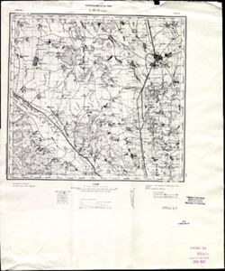
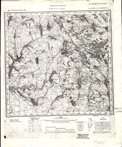
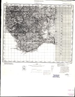
-
- Description:
- 1894
- Subject:
- Topical Subject: Maps, Topical Subject: Soviet Union, Geographic Subject: Zuya, and Geographic Subject: Republic of Crimea
- Publisher:
- Генеральный штаб Красной Армии
- Language:
- Russian
- Date Created:
- 1941
- Identifier:
- VAC9619-001957
- Genre:
- Military Maps and Topographic Maps
- Geographic Location:
- Coordinates: 45, 34, 45.3333, 34.5
- Related URL:
- Catalog URL: https://iucat.iu.edu/catalog/5020129 and Download GeoTIFF: https://drive.google.com/open?id=1OnZgZa5AYScso5JZKHdHoMlUXdIKTLCN
- Abstract:
- Modern area represented: Зуя (Zuya), Republic of Crimea, Ukraine
- Call Number:
- G7000 s100 .S7 sheet L-36-105
- Caption:
- Для cлужебного пользования
- City:
- Зуя (Zuya)
- Copyright Holder:
- No Copyright - United States
- Country:
- СССР (USSR)
- State/Province:
- РСФСР (RSFSR) and Крымская АССР (Crimean Autonomous Soviet Socialist Republic)
- Physical Description:
- Scale: 1:100,000
- Persistent URL:
- http://purl.dlib.indiana.edu/iudl/images/VAC9619/VAC9619-001957
- Provenance:
- CIA Map Library
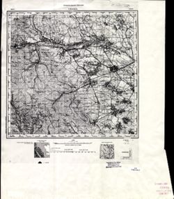
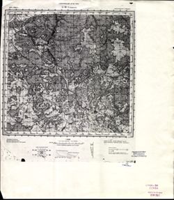
-
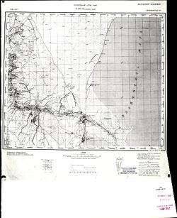
- Description:
- 1895
- Subject:
- Geographic Subject: Republic of Crimea, Geographic Subject: Saki, Topical Subject: Soviet Union, and Topical Subject: Maps
- Publisher:
- Генеральный штаб Красной Армии
- Language:
- Russian
- Date Created:
- 1941
- Identifier:
- VAC9619-001956
- Genre:
- Topographic Maps and Military Maps
- Geographic Location:
- Coordinates: 45, 33.5, 45.3333, 34
- Related URL:
- Download GeoTIFF: https://drive.google.com/open?id=1KeZQMnq0svWW8sbbr2gRu_IXfdHE5Zod and Catalog URL: https://iucat.iu.edu/catalog/5020129
- Abstract:
- Modern area represented: Саки (Saki), Republic of Crimea, Ukraine
- Call Number:
- G7000 s100 .S7 sheet L-36-104
- Caption:
- Для cлужебного пользования
- City:
- Саки (Saki)
- Copyright Holder:
- No Copyright - United States
- Country:
- СССР (USSR)
- State/Province:
- РСФСР (RSFSR)
- Physical Description:
- Scale: 1:100,000
- Persistent URL:
- http://purl.dlib.indiana.edu/iudl/images/VAC9619/VAC9619-001956
- Provenance:
- CIA Map Library
-
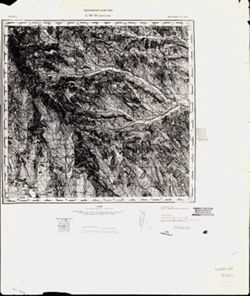
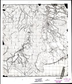
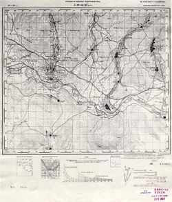
- Description:
- 1926
- Subject:
- Topical Subject: Maps, Geographic Subject: Tomakivka, and Topical Subject: Soviet Union
- Publisher:
- Генеральный штаб Красной Армии
- Language:
- Russian
- Date Created:
- 1941
- Identifier:
- VAC9619-001823
- Genre:
- Topographic Maps and Military Maps
- Geographic Location:
- Coordinates: 47.6667, 34.5, 48, 35
- Related URL:
- Download GeoTIFF: https://drive.google.com/file/d/14Nyu2PujbMSA_GYJjeQF3P2MPNH2zV-g/view?usp=sharing and Catalog URL: https://iucat.iu.edu/catalog/5020129
- Abstract:
- Modern area represented: Tomakivka, Dnipropetrovsk oblast, Ukraine
- Call Number:
- G7000 s100 .S7 sheet L-36-10
- Caption:
- Для служебного пользования
- City:
- Томаковка (Tomakivka)
- Copyright Holder:
- No Copyright - United States
- Country:
- СССР (USSR)
- State/Province:
- Запорожская область (Zaporizhia oblast) and Украинская ССР (Ukrainian Soviet Socialist Republic)
- Physical Description:
- Scale: 1:100,000
- Persistent URL:
- http://purl.dlib.indiana.edu/iudl/images/VAC9619/VAC9619-001823
- Provenance:
- CIA Map Library
-
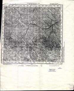
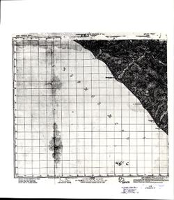
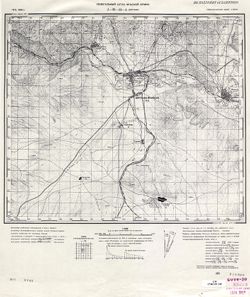
- Description:
- 1875
- Subject:
- Topical Subject: Maps, Topical Subject: Soviet Union, and Geographic Subject: Berezyne
- Publisher:
- Генеральный штаб РККА
- Language:
- Russian
- Date Created:
- 1916
- Identifier:
- VAC9619-001629
- Genre:
- Military Maps and Topographic Maps
- Geographic Location:
- Coordinates: 46, 29, 46.3333, 29.5
- Related URL:
- Catalog URL: https://iucat.iu.edu/catalog/5020129 and Download GeoTIFF: https://drive.google.com/open?id=1C3sEntFJccgyBICFoDtKC-3pwp46wFsk
- Abstract:
- Modern area represented: Berezyne, Odessa oblast, Ukraine.
- Call Number:
- G7000 s100 .S7 sheet L-35-71
- City:
- Березина (Berezyne)
- Copyright Holder:
- No Copyright - United States
- Country:
- СССР (USSR)
- State/Province:
- Бессарабия (Bessarabia)
- Physical Description:
- Scale: 1:100,000
- Persistent URL:
- http://purl.dlib.indiana.edu/iudl/images/VAC9619/VAC9619-001629
- Provenance:
- CIA Map Library
-
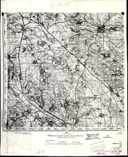
- Description:
- 1893
- Subject:
- Topical Subject: Maps, Topical Subject: Soviet Union, and Geographic Subject: Adjud
- Publisher:
- Генеральный штаб РККА
- Language:
- Russian
- Date Created:
- 1896
- Identifier:
- VAC9619-001612
- Genre:
- Topographic Maps and Military Maps
- Geographic Location:
- Coordinates: 46, 27, 46.3333, 27.5
- Related URL:
- Catalog URL: https://iucat.iu.edu/catalog/5020129 and Download GeoTIFF: https://drive.google.com/file/d/1-KZEpM-IuVFk53H5qXK4isCnJ-3W7KMJ/view?usp=sharing
- Abstract:
- Modern area represented: Adjud, Vrancea county, Romania
- Call Number:
- G7000 s100 .S7 sheet L-35-67
- City:
- Аджуд Ноуа (Adjudu Nou)
- Copyright Holder:
- No Copyright - United States
- Country:
- Румыния (Romania)
- Physical Description:
- Scale: 1:100,000
- Persistent URL:
- http://purl.dlib.indiana.edu/iudl/images/VAC9619/VAC9619-001612
- Provenance:
- CIA Map Library
-
- Description:
- 1891
- Subject:
- Topical Subject: Soviet Union, Topical Subject: Maps, and Geographic Subject: Dragomireşti
- Publisher:
- Генеральный штаб Красной Армии
- Language:
- Russian
- Date Created:
- 1940
- Identifier:
- VAC9619-001755
- Genre:
- Military Maps and Topographic Maps
- Geographic Location:
- Coordinates: 46.3333, 27, 46.6667, 27.5
- Related URL:
- Download GeoTIFF: https://drive.google.com/file/d/1hCPO_hgwRlOoKYWPQdYYSitq_p-y_Ezx/view?usp=sharing and Catalog URL: https://iucat.iu.edu/catalog/5020129
- Abstract:
- Modern area represented: Dragomireşti, Vaslui county, Romania
- Call Number:
- G7000 s100 .S7 sheet L-35-55
- City:
- Драгомирешти (Dragomireşti)
- Copyright Holder:
- No Copyright - United States
- Country:
- Румыния (Romania)
- Physical Description:
- Scale: 1:100,000
- Persistent URL:
- http://purl.dlib.indiana.edu/iudl/images/VAC9619/VAC9619-001755
- Provenance:
- CIA Map Library
-
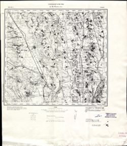
- Subject:
- Topical Subject: Maps, Topical Subject: Soviet Union, and Geographic Subject: Dorohoi
- Language:
- Russian
- Identifier:
- VAC9619-001484
- Genre:
- Military Maps and Topographic Maps
- Geographic Location:
- Coordinates: 47.6667, 26, 48, 26.5
- Related URL:
- Download GeoTIFF: https://drive.google.com/open?id=1_okPkJQP2ytUi_A9hy_wDuSNNnN_6zmt and Catalog URL: https://iucat.iu.edu/catalog/5020129
- Abstract:
- Modern area represented: Dorohoi, Botoşani county, Romania
- Call Number:
- G7000 s100 .S7 sheet L-35-5
- Copyright Holder:
- No Copyright - United States
- Physical Description:
- Scale: 1:100,000
- Persistent URL:
- http://purl.dlib.indiana.edu/iudl/images/VAC9619/VAC9619-001484
- Provenance:
- CIA Map Library
-
- Description:
- 1875
- Subject:
- Topical Subject: Soviet Union, Geographic Subject: Tiraspol, and Topical Subject: Maps
- Publisher:
- Генеральный штаб РККА
- Language:
- Russian
- Date Created:
- 1929
- Identifier:
- VAC9619-001718
- Genre:
- Military Maps and Topographic Maps
- Geographic Location:
- Coordinates: 46.6667, 29.5, 47, 30
- Related URL:
- Catalog URL: https://iucat.iu.edu/catalog/5020129 and Download GeoTIFF: https://drive.google.com/open?id=1-hf6LeF3eCsdwqOwg-k3BLxRce9hfH9t
- Abstract:
- Modern area represented: Tiraspol, Stînga Nistrului, Moldova
- Call Number:
- G7000 s100 .S7 sheet L-35-48
- Caption:
- Не подлежит оглашению
- City:
- Тирасполь (Tiraspol)
- Copyright Holder:
- No Copyright - United States
- State/Province:
- Украинская ССР (Ukrainian Soviet Socialist Republic), Молдавская АССР (Moldavian Autonomous Soviet Socialist Republic), Бессарабия (Bessarabia), and Одесская...
- Physical Description:
- Scale: 1:100,000
- Persistent URL:
- http://purl.dlib.indiana.edu/iudl/images/VAC9619/VAC9619-001718
- Provenance:
- CIA Map Library
-
- Description:
- 1888
- Subject:
- Topical Subject: Maps, Geographic Subject: Roman, and Topical Subject: Soviet Union
- Publisher:
- Генеральный штаб РККА
- Language:
- Russian
- Date Created:
- 1940
- Identifier:
- VAC9619-001540
- Genre:
- Military Maps and Topographic Maps
- Geographic Location:
- Coordinates: 46.6667, 26.5, 47, 27
- Related URL:
- Download GeoTIFF: https://drive.google.com/open?id=1i2pvbe1wRYaxyTOVF2cgHePtUEz_ZnoF and Catalog URL: https://iucat.iu.edu/catalog/5020129
- Abstract:
- Modern area represented: Roman, Neamţ county, Romania
- Call Number:
- G7000 s100 .S7 sheet L-35-42
- City:
- Роман (Roman)
- Copyright Holder:
- No Copyright - United States
- Country:
- Румыния (Romania)
- Physical Description:
- Scale: 1:100,000
- Persistent URL:
- http://purl.dlib.indiana.edu/iudl/images/VAC9619/VAC9619-001540
- Provenance:
- CIA Map Library
-
- Description:
- 1894
- Subject:
- Geographic Subject: Radauti, Topical Subject: Maps, and Topical Subject: Soviet Union
- Publisher:
- Управление военных топографов
- Language:
- Russian
- Date Created:
- 1896
- Identifier:
- VAC9619-001476
- Genre:
- Military Maps and Topographic Maps
- Geographic Location:
- Coordinates: 47.6667, 25.5, 48, 26
- Related URL:
- Catalog URL: https://iucat.iu.edu/catalog/5020129 and Download GeoTIFF: https://drive.google.com/open?id=1Fs-EOKsTjzwn8kRjdd33KxXLufCNUkix
- Abstract:
- Modern area represented: Radauti, Suceava county, Romania
- Call Number:
- G7000 s100 .S7 sheet L-35-4
- Caption:
- Для служебного пользования
- City:
- Рэдэуци (Radauti)
- Copyright Holder:
- No Copyright - United States
- Country:
- Румыния (Romania)
- Physical Description:
- Scale: 1:100,000
- Persistent URL:
- http://purl.dlib.indiana.edu/iudl/images/VAC9619/VAC9619-001476
- Provenance:
- CIA Map Library
-
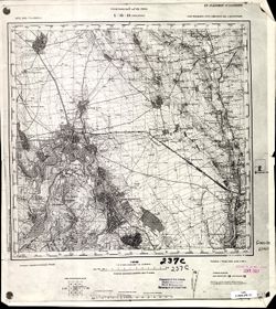
- Description:
- 1873
- Subject:
- Topical Subject: Soviet Union, Topical Subject: Maps, and Geographic Subject: Călărasi-Targ
- Publisher:
- Генеральный штаб РККА
- Language:
- Russian
- Date Created:
- 1940
- Identifier:
- VAC9619-001529
- Genre:
- Topographic Maps and Military Maps
- Geographic Location:
- Coordinates: 47, 28, 47.3333, 28.5
- Related URL:
- Download GeoTIFF: https://drive.google.com/open?id=1tChuAu9yqWs5ys8Z7tNhOEmgq69Apb3I and Catalog URL: https://iucat.iu.edu/catalog/5020129
- Abstract:
- Modern area represented: Călărasi-Targ, Călăraşi county, Moldova
- Call Number:
- G7000 s100 .S7 sheet L-35-33
- City:
- Калараш-Тырг (Călărasi-Targ)
- Copyright Holder:
- No Copyright - United States
- Country:
- Румыния (Romania)
- State/Province:
- Бессарабия (Bessarabia)
- Physical Description:
- Scale: 1:100,000
- Persistent URL:
- http://purl.dlib.indiana.edu/iudl/images/VAC9619/VAC9619-001529
- Provenance:
- CIA Map Library
-
- Description:
- 1873
- Subject:
- Geographic Subject: Selyatyn, Topical Subject: Maps, and Topical Subject: Soviet Union
- Publisher:
- Генеральный штаб Красной Армии
- Language:
- Russian
- Date Created:
- 1939
- Identifier:
- VAC9619-001472
- Genre:
- Military Maps and Topographic Maps
- Geographic Location:
- Coordinates: 47.6667, 25, 48, 25.5
- Related URL:
- Download GeoTIFF: https://drive.google.com/open?id=1v6zIUxpzw2mb5AD7jE4-hVpFfWBpe8B8 and Catalog URL: https://iucat.iu.edu/catalog/5020129
- Abstract:
- Modern area represented: Selyatyn, Chernivtsi oblast, Ukraine
- Call Number:
- G7000 s100 .S7 sheet L-35-3
- Caption:
- Для служебного пользования
- City:
- Селетин (Selyatyn)
- Copyright Holder:
- No Copyright - United States
- Country:
- Румыния (Romania)
- State/Province:
- Украинская ССР (Ukrainian Soviet Socialist Republic) and Черновицкая область (Chernivtsi oblast)
- Physical Description:
- Scale: 1:100,000
- Persistent URL:
- http://purl.dlib.indiana.edu/iudl/images/VAC9619/VAC9619-001472
- Provenance:
- CIA Map Library
-
- Description:
- 1873
- Subject:
- Topical Subject: Maps, Topical Subject: Soviet Union, and Geographic Subject: Slobidka
- Publisher:
- Генеральный штаб РККА
- Language:
- Russian
- Date Created:
- 1933
- Identifier:
- VAC9619-001502
- Genre:
- Military Maps and Topographic Maps
- Geographic Location:
- Coordinates: 47.6667, 29, 48, 29.5
- Related URL:
- Download GeoTIFF: https://drive.google.com/open?id=12hPOl2XNIpsYO7n4_yTuCA5VYkAUpSEV and Catalog URL: https://iucat.iu.edu/catalog/5020129
- Abstract:
- Modern area represented: Slobidka, Odessa oblast, Ukraine
- Call Number:
- G7000 s100 .S7 sheet L-35-11
- Caption:
- Не подлежит оглашению
- City:
- Пос. Слободка (Slobodka village)
- Copyright Holder:
- No Copyright - United States
- State/Province:
- Украинская ССР (Ukrainian Soviet Socialist Republic), Бессарабия (Bessarabia), and Молдавская АССР (Moldavian Autonomous Soviet Socialist Republic)
- Physical Description:
- Scale: 1:100,000
- Persistent URL:
- http://purl.dlib.indiana.edu/iudl/images/VAC9619/VAC9619-001502
- Provenance:
- CIA Map Library
-
- Description:
- 1874
- Subject:
- Topical Subject: Maps, Topical Subject: Soviet Union, and Geographic Subject: Velykyy Bychkiv
- Publisher:
- Генеральный штаб РККА
- Language:
- Russian
- Date Created:
- 1930
- Identifier:
- VAC9619-001463
- Genre:
- Topographic Maps and Military Maps
- Geographic Location:
- Coordinates: 47.6667, 24, 48, 24.5
- Related URL:
- Download GeoTIFF: https://drive.google.com/open?id=1-ZSf5C8bFAhpm68pW7TQgPOdfxwZluL5 and Catalog URL: https://iucat.iu.edu/catalog/5020129
- Abstract:
- Modern area represented: Velykyy Bychkiv, Transcarpathia oblast, Ukraine
- Call Number:
- G7000 s100 .S7 sheet L-35-1
- City:
- Над-Бочко (Nad-Bochko)
- Copyright Holder:
- No Copyright - United States
- Country:
- Чехословакия (Czechoslovakia) and Румыния (Romania)
- Physical Description:
- Scale: 1:100,000
- Persistent URL:
- http://purl.dlib.indiana.edu/iudl/images/VAC9619/VAC9619-001463
- Provenance:
- CIA Map Library
-
- Subject:
- Topical Subject: Maps, Geographic Subject: Aleksandriyskaya, and Topical Subject: Soviet Union
- Publisher:
- Генеральный штаб Красной Армии
- Language:
- Russian
- Identifier:
- VAC9619-000813
- Genre:
- Topographic Maps and Military Maps
- Related URL:
- Catalog URL: https://iucat.iu.edu/catalog/5020129
- Abstract:
- Modern area represented: Aleksandriyskaya, Dagestan republic, Russia
- Call Number:
- G7000 s100 .S7 sheet K-38-11
- Copyright Holder:
- No Copyright - United States
- Country:
- СССР (USSR)
- Physical Description:
- Scale: 1:100,000
- Persistent URL:
- http://purl.dlib.indiana.edu/iudl/images/VAC9619/VAC9619-000813
- Provenance:
- CIA Map Library
-
- Description:
- 1905
- Subject:
- Topical Subject: Maps, Topical Subject: Soviet Union, and Geographic Subject: Lazarevskoye
- Publisher:
- Генеральный штаб Красной Армии
- Language:
- Russian
- Date Created:
- 1942
- Identifier:
- VAC9619-000759
- Genre:
- Topographic Maps and Military Maps
- Geographic Location:
- Coordinates: 43.6667, 39, 44, 39.5
- Related URL:
- Catalog URL: https://iucat.iu.edu/catalog/5020129 and Download GeoTIFF: https://drive.google.com/open?id=1OcoSmUSM2ZO6HwjSl9T2sxJaHo8Fbzui
- Abstract:
- Modern area represented: Lazarevskoye, Krasnodar kray, Russia
- Call Number:
- G7000 s100 .S7 sheet K-37-7
- Caption:
- Для служебного пользования
- City:
- Лазаревская (Lazarevskoye)
- Copyright Holder:
- No Copyright - United States
- Country:
- СССР (USSR)
- State/Province:
- Краснодарская область (Krasnodar oblast) and РСФСР (RSFSR)
- Physical Description:
- Scale: 1:100,000
- Persistent URL:
- http://purl.dlib.indiana.edu/iudl/images/VAC9619/VAC9619-000759
- Provenance:
- CIA Map Library
-
- Description:
- 1937
- Subject:
- Topical Subject: Maps, Geographic Subject: Astara, and Topical Subject: Soviet Union
- Publisher:
- Генеральный штаб РККА
- Language:
- Russian
- Identifier:
- VAC9619-000725
- Genre:
- Topographic Maps and Military Maps
- Geographic Location:
- Coordinates: 38.3333, 48.5, 38.6667, 49
- Related URL:
- Download GeoTIFF: https://drive.google.com/open?id=1ajZ_qTkkt--5Ug3YN3kUgBsa3aGAOS3v and Catalog URL: https://iucat.iu.edu/catalog/5020129
- Abstract:
- Modern area represented: Astara, Astara district, Azerbaijan
- Call Number:
- G7000 s100 .S7 sheet J-39-50
- Caption:
- Не подлежит оглашению
- City:
- Аз.Астара (Astara)
- Copyright Holder:
- No Copyright - United States
- Country:
- Иран (Iran)
- State/Province:
- Азербайджанская ССР (Azerbaijan Soviet Socialist Republic)
- Physical Description:
- Scale: 1:100,000
- Persistent URL:
- http://purl.dlib.indiana.edu/iudl/images/VAC9619/VAC9619-000725
- Provenance:
- CIA Map Library
-
- Description:
- 1936
- Subject:
- Topical Subject: Soviet Union, Geographic Subject: Severo-Vostotchniy Bank, and Topical Subject: Maps
- Publisher:
- Генеральный штаб РККА
- Language:
- Russian
- Date Created:
- 1938
- Identifier:
- VAC9619-000703
- Genre:
- Military Maps and Topographic Maps
- Geographic Location:
- Coordinates: 39.3333, 49, 39.6667, 49.5
- Related URL:
- Download GeoTIFF: https://drive.google.com/open?id=1HOzW0uYJbq0-VXAANvgVEp_5GSg3IWt1 and Catalog URL: https://iucat.iu.edu/catalog/5020129
- Abstract:
- Modern area represented: Severo-Vostotchniy Bank, Neftçala district, Azerbaijan
- Call Number:
- G7000 s100 .S7 sheet J-39-15
- Caption:
- Не подлежит оглашению
- City:
- Сев. Вост. Банк (Severo-Vostotchnyi Bank)
- Copyright Holder:
- No Copyright - United States
- Country:
- СССР (USSR)
- State/Province:
- Азербайджанская ССР (Azerbaijan Soviet Socialist Republic)
- Physical Description:
- Scale: 1:100,000
- Persistent URL:
- http://purl.dlib.indiana.edu/iudl/images/VAC9619/VAC9619-000703
- Provenance:
- CIA Map Library
-
- Subject:
- Topical Subject: Maps, Geographic Subject: Dəstə, and Topical Subject: Soviet Union
- Publisher:
- Управление военных топографов РККА
- Language:
- Russian
- Identifier:
- VAC9619-000090
- Genre:
- Topographic Maps and Military Maps
- Geographic Location:
- Coordinates: 38.8333, 45.75, 39, 46
- Related URL:
- Catalog URL: http://iucat.iu.edu/catalog/5020131 and Download GeoTIFF: https://drive.google.com/open?id=1pFD5b_LTz9_uPfPztyc3ps6TCSBVhjob
- Abstract:
- Modern area represented: Dəstə, Azerbaijan
- Call Number:
- G7000 s50 .S68 sheet J-38-44-B
- Caption:
- Не подлежит оглашению
- City:
- Даста (Dasta)
- Copyright Holder:
- No Copyright - United States
- Country:
- СССР (USSR) and Иран (Iran)
- State/Province:
- Азербайджанская ССР (Azerbaijan Soviet Socialist Republic)
- Physical Description:
- Scale: 1:50,000
- Persistent URL:
- http://purl.dlib.indiana.edu/iudl/images/VAC9619/VAC9619-000090
- Provenance:
- CIA Map Library
-
- Subject:
- Topical Subject: Maps, Topical Subject: Soviet Union, and Geographic Subject: Julfa
- Publisher:
- Генеральный штаб Красной Армии
- Language:
- Russian
- Date Created:
- 1940
- Identifier:
- VAC9619-000089
- Genre:
- Topographic Maps and Military Maps
- Geographic Location:
- Coordinates: 38.8333, 45.5, 39, 45.75
- Related URL:
- Download GeoTIFF: https://drive.google.com/open?id=1fZhMoeilfY5E-PsoYnAeUMHJQW6GUmXx and Catalog URL: http://iucat.iu.edu/catalog/5020131
- Abstract:
- Modern area represented: Julfa, Azerbaijan
- Call Number:
- G7000 s50 .S68 sheet J-38-44-A
- Caption:
- Не подлежит оглашению
- City:
- Джульфа (Dzhulfa)
- Copyright Holder:
- No Copyright - United States
- Country:
- Иран (Iran) and СССР (USSR)
- State/Province:
- Нахичеванская АССР (Nakhichevan Autonomous Soviet Socialist Republic)
- Physical Description:
- Scale: 1:50,000
- Persistent URL:
- http://purl.dlib.indiana.edu/iudl/images/VAC9619/VAC9619-000089
- Provenance:
- CIA Map Library
