
Search Constraints
Search Results
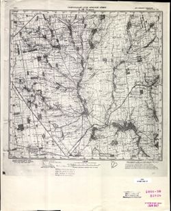
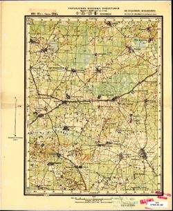
-
- Description:
- 1892
- Subject:
- Topical Subject: Soviet Union, Geographic Subject: Lisino, and Topical Subject: Maps
- Publisher:
- Управление военных топографов
- Language:
- Russian
- Date Created:
- 1930
- Identifier:
- VAC9619-001816
- Genre:
- Military Maps and Topographic Maps
- Geographic Location:
- Coordinates: 59.333, 29.5, 59.5, 29.75
- Related URL:
- Download GeoTIFF: https://drive.google.com/open?id=1OnfPVS9duvomkdlCn3AVO6GdNujFS7rQ and Catalog URL: http://iucat.iu.edu/catalog/5020131
- Abstract:
- Modern area represented: Lisino, Leningrad oblast, Russia
- Call Number:
- G7000 s50 .S68 sheet O-35-24-В
- Caption:
- Не подлежит оглашению
- City:
- Лисино (Lisino)
- Copyright Holder:
- No Copyright - United States
- Country:
- СССР (USSR)
- State/Province:
- РСФСР (RSFSR) and Ленинградская область (Leningrad oblast)
- Physical Description:
- Scale: 1:50,000
- Persistent URL:
- http://purl.dlib.indiana.edu/iudl/images/VAC9619/VAC9619-001816
- Provenance:
- Army Map Service Library, Library of Congress Geography & Map Division, OMAHA
-
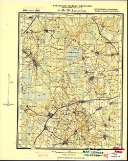
- Description:
- 1888
- Subject:
- Geographic Subject: Voyskovitsy, Topical Subject: Maps, and Topical Subject: Soviet Union
- Publisher:
- Управление военных топографов
- Language:
- Russian
- Date Created:
- 1931
- Identifier:
- VAC9619-001815
- Genre:
- Topographic Maps and Military Maps
- Geographic Location:
- Coordinates: 59.5, 29.75, 59.667, 30
- Related URL:
- Download GeoTIFF: https://drive.google.com/open?id=1SgkC34g9WUciNky8m09YCW5gMVy5ZYtm and Catalog URL: http://iucat.iu.edu/catalog/5020131
- Abstract:
- Modern area represented: Voyskovitsy, Leningrad oblast, Russia
- Call Number:
- G7000 s50 .S68 sheet O-35-24-B
- Caption:
- Не подлежит оглашению
- City:
- Ст. Войсковицы (Voyskovitsy)
- Copyright Holder:
- No Copyright - United States
- Country:
- СССР (USSR)
- State/Province:
- РСФСР (RSFSR) and Ленинградская область (Leningrad oblast)
- Physical Description:
- Scale: 1:50,000
- Persistent URL:
- http://purl.dlib.indiana.edu/iudl/images/VAC9619/VAC9619-001815
- Provenance:
- DMA Topographic Center, Army Map Service Library, OMAHA, Library of Congress Geography & Map Division
-
- Description:
- 1890
- Subject:
- Topical Subject: Maps, Topical Subject: Soviet Union, and Geographic Subject: Vitino
- Publisher:
- Управление военных топографов
- Language:
- Russian
- Date Created:
- 1931
- Identifier:
- VAC9619-001814
- Genre:
- Topographic Maps and Military Maps
- Geographic Location:
- Coordinates: 59.5, 29.5, 59.667, 29.75
- Related URL:
- Catalog URL: http://iucat.iu.edu/catalog/5020131 and Download GeoTIFF: https://drive.google.com/open?id=18aF5a2EXP4k7hMJ4kUjYbdjGZWY7_O2d
- Abstract:
- Modern area represented: Vitino, Leningrad oblast, Russia
- Call Number:
- G7000 s50 .S68 sheet O-35-24-A
- Caption:
- Не подлежит оглашению
- City:
- Витино (Vitino)
- Copyright Holder:
- No Copyright - United States
- Country:
- СССР (USSR)
- State/Province:
- РСФСР (RSFSR) and Ленинградская область (Leningrad oblast)
- Physical Description:
- Scale: 1:50,000
- Persistent URL:
- http://purl.dlib.indiana.edu/iudl/images/VAC9619/VAC9619-001814
- Provenance:
- DMA Topographic Center, Army Map Service Library, Library of Congress Geography & Map Division
-
- Description:
- 1925
- Subject:
- Topical Subject: Maps, Topical Subject: Soviet Union, and Geographic Subject: Kamenka
- Publisher:
- Генеральный штаб Красной Армии
- Language:
- Russian
- Date Created:
- 1941
- Identifier:
- VAC9619-001813
- Genre:
- Topographic Maps and Military Maps
- Geographic Location:
- Coordinates: 47.6667, 33.5, 48, 34
- Related URL:
- Catalog URL: https://iucat.iu.edu/catalog/5020129 and Download GeoTIFF: https://drive.google.com/open?id=1Znt6fiuoSKmhSW96ISNtk6soCbJclKeG
- Abstract:
- Modern area represented: Kamenka, Dnipropetrovsk oblast, Ukraine
- Call Number:
- G7000 s100 .S7 sheet L-36-8
- Caption:
- Для служебного пользования
- City:
- Каменка (Kamenka)
- Copyright Holder:
- No Copyright - United States
- Country:
- СССР (USSR)
- State/Province:
- Украинская ССР (Ukrainian Soviet Socialist Republic)
- Physical Description:
- Scale: 1:100,000
- Persistent URL:
- http://purl.dlib.indiana.edu/iudl/images/VAC9619/VAC9619-001813
- Provenance:
- CIA Map Library
-
- Description:
- 1891
- Subject:
- Topical Subject: Maps, Geographic Subject: Klopitsy, and Topical Subject: Soviet Union
- Publisher:
- Управление военных топографов
- Language:
- Russian
- Date Created:
- 1930
- Identifier:
- VAC9619-001812
- Genre:
- Military Maps and Topographic Maps
- Geographic Location:
- Coordinates: 59.5, 29.25, 59.667, 29.5
- Related URL:
- Catalog URL: http://iucat.iu.edu/catalog/5020131 and Download GeoTIFF: https://drive.google.com/open?id=11ODaCbSDHcjz8c7V4gk2zB2hdZHykvgZ
- Abstract:
- Modern area represented: Klopitsy, Leningrad oblast, Russia
- Call Number:
- G7000 s50 .S68 sheet O-35-23-B
- Caption:
- Не подлежит оглашению
- City:
- Клопицы (Klopitsy)
- Copyright Holder:
- No Copyright - United States
- Country:
- СССР (USSR)
- State/Province:
- РСФСР (RSFSR) and Ленинградская область (Leningrad oblast)
- Physical Description:
- Scale: 1:50,000
- Persistent URL:
- http://purl.dlib.indiana.edu/iudl/images/VAC9619/VAC9619-001812
- Provenance:
- M. I. Map Library, Atlasblatt
-
- Description:
- 1892
- Subject:
- Topical Subject: Maps, Topical Subject: Soviet Union, and Geographic Subject: Korchany
- Publisher:
- Управление военных топографов
- Language:
- Russian
- Date Created:
- 1930
- Identifier:
- VAC9619-001811
- Genre:
- Topographic Maps and Military Maps
- Geographic Location:
- Coordinates: 59.5, 29, 59.667, 29.25
- Related URL:
- Download GeoTIFF: https://drive.google.com/open?id=1kpilxBJamWXIvUXxCViAVHF-DrW5zjhE and Catalog URL: http://iucat.iu.edu/catalog/5020131
- Abstract:
- Modern area represented: Korchany, Leningrad oblast, Russia
- Call Number:
- G7000 s50 .S68 sheet O-35-23-A
- Caption:
- Не подлежит оглашению
- City:
- Бол. Карчаны (Bolshiye Karchany)
- Copyright Holder:
- No Copyright - United States
- Country:
- СССР (USSR)
- State/Province:
- РСФСР (RSFSR) and Ленинградская область (Leningrad oblast)
- Physical Description:
- Scale: 1:50,000
- Persistent URL:
- http://purl.dlib.indiana.edu/iudl/images/VAC9619/VAC9619-001811
- Provenance:
- M. I. Map Library, Atlasblatt, CIA Map Library
-

- Description:
- 1913
- Subject:
- Topical Subject: Maps, Topical Subject: Soviet Union, and Geographic Subject: Olteniţa
- Publisher:
- Генеральный штаб РККА
- Language:
- Russian
- Identifier:
- VAC9619-001810
- Genre:
- Topographic Maps and Military Maps
- Geographic Location:
- Coordinates: 44, 26.5, 44.3333, 27
- Related URL:
- Download GeoTIFF: https://drive.google.com/open?id=1K5wkGkvRkUeJl-5zDMfxLkj3JNBf0BuA and Catalog URL: https://iucat.iu.edu/catalog/5020129
- Abstract:
- Modern area represented: Olteniţa, Călăraşi county, Romania
- Call Number:
- G7000 s100 .S7 sheet L-35-138
- City:
- Олтеница (Olteniţa)
- Copyright Holder:
- No Copyright - United States
- Country:
- Румыния (Romania)
- Physical Description:
- Scale: 1:100,000
- Persistent URL:
- http://purl.dlib.indiana.edu/iudl/images/VAC9619/VAC9619-001810
- Provenance:
- DMA Topographic Center, Army Map Service Library, OMAHA, Atlasblatt, Library of Congress Geography & Map Division
-
- Description:
- 1893
- Subject:
- Topical Subject: Maps, Topical Subject: Soviet Union, and Geographic Subject: Budeşti
- Publisher:
- Генеральный штаб Красной Армии
- Language:
- Russian
- Date Created:
- 1940
- Identifier:
- VAC9619-001809
- Genre:
- Military Maps and Topographic Maps
- Geographic Location:
- Coordinates: 44, 26, 44.3333, 26.5
- Related URL:
- Catalog URL: https://iucat.iu.edu/catalog/5020129 and Download GeoTIFF: https://drive.google.com/open?id=1tDXhb1hBuYrOkSbvJmeKh7J1IEkm384b
- Abstract:
- Modern area represented: Budeşti, Giurgiu county, Romania
- Call Number:
- G7000 s100 .S7 sheet L-35-137
- City:
- Будешти (Budeşti)
- Copyright Holder:
- No Copyright - United States
- Country:
- Румыния (Romania) and Болгария (Bulgaria)
- Physical Description:
- Scale: 1:100,000
- Persistent URL:
- http://purl.dlib.indiana.edu/iudl/images/VAC9619/VAC9619-001809
- Provenance:
- DMA Topographic Center, Army Map Service Library, Library of Congress Geography & Map Division
-
- Description:
- 1883
- Subject:
- Topical Subject: Maps, Geographic Subject: Drăgăneşti-Vlaşca, and Topical Subject: Soviet Union
- Publisher:
- Генеральный штаб Красной Армии
- Language:
- Russian
- Date Created:
- 1940
- Identifier:
- VAC9619-001808
- Genre:
- Topographic Maps and Military Maps
- Geographic Location:
- Coordinates: 44, 25.5, 44.3333, 26
- Related URL:
- Download GeoTIFF: https://drive.google.com/open?id=1kk3WO5ndJeaX7rwmkETltz7GczrbyMJb and Catalog URL: https://iucat.iu.edu/catalog/5020129
- Abstract:
- Modern area represented: Drăgăneşti-Vlaşca, Giurgiu county, Romania
- Call Number:
- G7000 s100 .S7 sheet L-35-136
- City:
- Дрэгэнешти (Drăgăneşti)
- Copyright Holder:
- No Copyright - United States
- Country:
- Румыния (Romania)
- Physical Description:
- Scale: 1:100,000
- Persistent URL:
- http://purl.dlib.indiana.edu/iudl/images/VAC9619/VAC9619-001808
- Provenance:
- DMA Topographic Center, Army Map Service Library, Library of Congress Geography & Map Division
-
- Description:
- 1894
- Subject:
- Topical Subject: Soviet Union, Topical Subject: Maps, and Geographic Subject: Vaivara Parish
- Publisher:
- Управление военных топографов
- Language:
- Russian
- Date Created:
- 1939
- Identifier:
- VAC9619-001807
- Genre:
- Military Maps and Topographic Maps
- Geographic Location:
- Coordinates: 59.333, 27.75, 59.5, 28
- Related URL:
- Catalog URL: http://iucat.iu.edu/catalog/5020131 and Download GeoTIFF: https://drive.google.com/open?id=1xZRkvws2fTzTf7QBQ5p6dQ2m53SU1f7c
- Abstract:
- Modern area represented: Vaivara Parish, Ida-Viru county, Estonia
- Call Number:
- G7000 s50 .S68 sheet O-35-20-D
- City:
- Вайвара (Vaivara)
- Copyright Holder:
- No Copyright - United States
- Country:
- Эстония (Estonia)
- Physical Description:
- Scale: 1:50,000
- Persistent URL:
- http://purl.dlib.indiana.edu/iudl/images/VAC9619/VAC9619-001807
- Provenance:
- DMA Topographic Center, Army Map Service Library, OMAHA, Library of Congress Geography & Map Division
