
Search Constraints
You searched for:
Pages
0-99 pages
Remove constraint Pages: 0-99 pages
Provenance
CIA Map Library
Remove constraint Provenance: CIA Map Library
« Previous |
1 - 10 of 172
|
Next »
Search Results
-
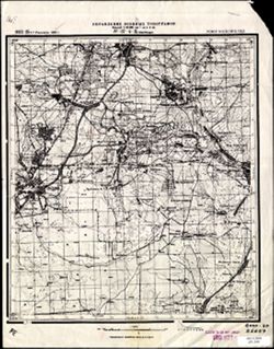
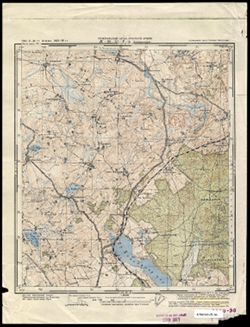
- Description:
- 1922
- Subject:
- Topical Subject: Soviet Union, Topical Subject: Maps, and Geographic Subject: Mytishchi
- Publisher:
- Управление военных топографов
- Language:
- Russian
- Date Created:
- 1929
- Identifier:
- VAC9619-001586
- Genre:
- Military Maps and Topographic Maps
- Geographic Location:
- Coordinates: 55.8667, 37.75, 56, 38
- Related URL:
- Catalog URL: http://iucat.iu.edu/catalog/5020131 and Download GeoTIFF: https://drive.google.com/open?id=1PxyJ7XDtUzjmwpjIlxN45-6k_XMUG50I
- Abstract:
- Modern area represented: Mytishchi, Moscow oblast, Russia
- Call Number:
- G7000 s50 .S68 sheet N-37-4-B
- City:
- Мытищи (Mytishchi)
- Copyright Holder:
- No Copyright - United States
- Country:
- СССР (USSR)
- State/Province:
- РСФСР (RSFSR) and Московская область (Moscow oblast)
- Physical Description:
- Scale: 1:50,000
- Persistent URL:
- http://purl.dlib.indiana.edu/iudl/images/VAC9619/VAC9619-001586
- Provenance:
- CIA Map Library
-
- Description:
- 1888
- Subject:
- Topical Subject: Maps, Geographic Subject: Roman, and Topical Subject: Soviet Union
- Publisher:
- Генеральный штаб РККА
- Language:
- Russian
- Date Created:
- 1940
- Identifier:
- VAC9619-001540
- Genre:
- Military Maps and Topographic Maps
- Geographic Location:
- Coordinates: 46.6667, 26.5, 47, 27
- Related URL:
- Download GeoTIFF: https://drive.google.com/open?id=1i2pvbe1wRYaxyTOVF2cgHePtUEz_ZnoF and Catalog URL: https://iucat.iu.edu/catalog/5020129
- Abstract:
- Modern area represented: Roman, Neamţ county, Romania
- Call Number:
- G7000 s100 .S7 sheet L-35-42
- City:
- Роман (Roman)
- Copyright Holder:
- No Copyright - United States
- Country:
- Румыния (Romania)
- Physical Description:
- Scale: 1:100,000
- Persistent URL:
- http://purl.dlib.indiana.edu/iudl/images/VAC9619/VAC9619-001540
- Provenance:
- CIA Map Library
-
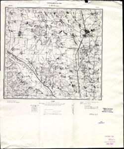
- Description:
- 1873
- Subject:
- Topical Subject: Soviet Union, Topical Subject: Maps, and Geographic Subject: Călărasi-Targ
- Publisher:
- Генеральный штаб РККА
- Language:
- Russian
- Date Created:
- 1940
- Identifier:
- VAC9619-001529
- Genre:
- Topographic Maps and Military Maps
- Geographic Location:
- Coordinates: 47, 28, 47.3333, 28.5
- Related URL:
- Download GeoTIFF: https://drive.google.com/open?id=1tChuAu9yqWs5ys8Z7tNhOEmgq69Apb3I and Catalog URL: https://iucat.iu.edu/catalog/5020129
- Abstract:
- Modern area represented: Călărasi-Targ, Călăraşi county, Moldova
- Call Number:
- G7000 s100 .S7 sheet L-35-33
- City:
- Калараш-Тырг (Călărasi-Targ)
- Copyright Holder:
- No Copyright - United States
- Country:
- Румыния (Romania)
- State/Province:
- Бессарабия (Bessarabia)
- Physical Description:
- Scale: 1:100,000
- Persistent URL:
- http://purl.dlib.indiana.edu/iudl/images/VAC9619/VAC9619-001529
- Provenance:
- CIA Map Library
-
- Description:
- 1873
- Subject:
- Topical Subject: Maps, Topical Subject: Soviet Union, and Geographic Subject: Slobidka
- Publisher:
- Генеральный штаб РККА
- Language:
- Russian
- Date Created:
- 1933
- Identifier:
- VAC9619-001502
- Genre:
- Military Maps and Topographic Maps
- Geographic Location:
- Coordinates: 47.6667, 29, 48, 29.5
- Related URL:
- Download GeoTIFF: https://drive.google.com/open?id=12hPOl2XNIpsYO7n4_yTuCA5VYkAUpSEV and Catalog URL: https://iucat.iu.edu/catalog/5020129
- Abstract:
- Modern area represented: Slobidka, Odessa oblast, Ukraine
- Call Number:
- G7000 s100 .S7 sheet L-35-11
- Caption:
- Не подлежит оглашению
- City:
- Пос. Слободка (Slobodka village)
- Copyright Holder:
- No Copyright - United States
- State/Province:
- Украинская ССР (Ukrainian Soviet Socialist Republic), Бессарабия (Bessarabia), and Молдавская АССР (Moldavian Autonomous Soviet Socialist Republic)
- Physical Description:
- Scale: 1:100,000
- Persistent URL:
- http://purl.dlib.indiana.edu/iudl/images/VAC9619/VAC9619-001502
- Provenance:
- CIA Map Library
-
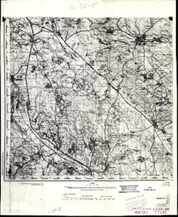
- Subject:
- Topical Subject: Maps, Topical Subject: Soviet Union, and Geographic Subject: Dorohoi
- Language:
- Russian
- Identifier:
- VAC9619-001484
- Genre:
- Military Maps and Topographic Maps
- Geographic Location:
- Coordinates: 47.6667, 26, 48, 26.5
- Related URL:
- Download GeoTIFF: https://drive.google.com/open?id=1_okPkJQP2ytUi_A9hy_wDuSNNnN_6zmt and Catalog URL: https://iucat.iu.edu/catalog/5020129
- Abstract:
- Modern area represented: Dorohoi, Botoşani county, Romania
- Call Number:
- G7000 s100 .S7 sheet L-35-5
- Copyright Holder:
- No Copyright - United States
- Physical Description:
- Scale: 1:100,000
- Persistent URL:
- http://purl.dlib.indiana.edu/iudl/images/VAC9619/VAC9619-001484
- Provenance:
- CIA Map Library
-
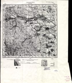
- Description:
- 1894
- Subject:
- Geographic Subject: Radauti, Topical Subject: Maps, and Topical Subject: Soviet Union
- Publisher:
- Управление военных топографов
- Language:
- Russian
- Date Created:
- 1896
- Identifier:
- VAC9619-001476
- Genre:
- Military Maps and Topographic Maps
- Geographic Location:
- Coordinates: 47.6667, 25.5, 48, 26
- Related URL:
- Catalog URL: https://iucat.iu.edu/catalog/5020129 and Download GeoTIFF: https://drive.google.com/open?id=1Fs-EOKsTjzwn8kRjdd33KxXLufCNUkix
- Abstract:
- Modern area represented: Radauti, Suceava county, Romania
- Call Number:
- G7000 s100 .S7 sheet L-35-4
- Caption:
- Для служебного пользования
- City:
- Рэдэуци (Radauti)
- Copyright Holder:
- No Copyright - United States
- Country:
- Румыния (Romania)
- Physical Description:
- Scale: 1:100,000
- Persistent URL:
- http://purl.dlib.indiana.edu/iudl/images/VAC9619/VAC9619-001476
- Provenance:
- CIA Map Library
-
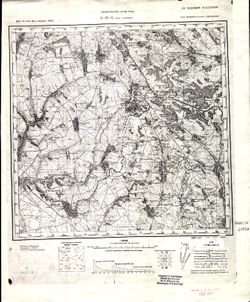
- Description:
- 1873
- Subject:
- Geographic Subject: Selyatyn, Topical Subject: Maps, and Topical Subject: Soviet Union
- Publisher:
- Генеральный штаб Красной Армии
- Language:
- Russian
- Date Created:
- 1939
- Identifier:
- VAC9619-001472
- Genre:
- Military Maps and Topographic Maps
- Geographic Location:
- Coordinates: 47.6667, 25, 48, 25.5
- Related URL:
- Download GeoTIFF: https://drive.google.com/open?id=1v6zIUxpzw2mb5AD7jE4-hVpFfWBpe8B8 and Catalog URL: https://iucat.iu.edu/catalog/5020129
- Abstract:
- Modern area represented: Selyatyn, Chernivtsi oblast, Ukraine
- Call Number:
- G7000 s100 .S7 sheet L-35-3
- Caption:
- Для служебного пользования
- City:
- Селетин (Selyatyn)
- Copyright Holder:
- No Copyright - United States
- Country:
- Румыния (Romania)
- State/Province:
- Украинская ССР (Ukrainian Soviet Socialist Republic) and Черновицкая область (Chernivtsi oblast)
- Physical Description:
- Scale: 1:100,000
- Persistent URL:
- http://purl.dlib.indiana.edu/iudl/images/VAC9619/VAC9619-001472
- Provenance:
- CIA Map Library
-
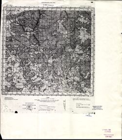
- Description:
- 1874
- Subject:
- Topical Subject: Maps, Topical Subject: Soviet Union, and Geographic Subject: Velykyy Bychkiv
- Publisher:
- Генеральный штаб РККА
- Language:
- Russian
- Date Created:
- 1930
- Identifier:
- VAC9619-001463
- Genre:
- Topographic Maps and Military Maps
- Geographic Location:
- Coordinates: 47.6667, 24, 48, 24.5
- Related URL:
- Download GeoTIFF: https://drive.google.com/open?id=1-ZSf5C8bFAhpm68pW7TQgPOdfxwZluL5 and Catalog URL: https://iucat.iu.edu/catalog/5020129
- Abstract:
- Modern area represented: Velykyy Bychkiv, Transcarpathia oblast, Ukraine
- Call Number:
- G7000 s100 .S7 sheet L-35-1
- City:
- Над-Бочко (Nad-Bochko)
- Copyright Holder:
- No Copyright - United States
- Country:
- Чехословакия (Czechoslovakia) and Румыния (Romania)
- Physical Description:
- Scale: 1:100,000
- Persistent URL:
- http://purl.dlib.indiana.edu/iudl/images/VAC9619/VAC9619-001463
- Provenance:
- CIA Map Library
-
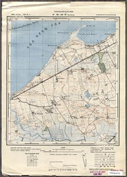
- Subject:
- Topical Subject: Maps, Geographic Subject: Kumiecie Małe, and Topical Subject: Soviet Union
- Publisher:
- Генеральный штаб Красной Армии
- Language:
- Russian
- Date Created:
- 1941
- Identifier:
- VAC9619-003778
- Genre:
- Topographic Maps and Military Maps
- Geographic Location:
- Coordinates: 54.33333, 22.25, 54.416667, 22.375
- Related URL:
- Catalog URL: https://iucat.iu.edu/catalog/14701157 and Download GeoTIFF: https://drive.google.com/file/d/1j12pjvPCePKzJkTpigHGtx5NAOBSbMzH/view?usp=sharing
- Abstract:
- Modern area represented: abandoned populated place. The nearest populated place is Kumiecie Małe (former Klein Kummetschen), Poland.
- Call Number:
- G7063.K2 s25 .S6 sheet N-34-57-D-c
- City:
- Ропонатшен (Roponatschen)
- Copyright Holder:
- No Copyright - United States
- Country:
- Германия (Восточная Пруссия) (Germany (East Prussia))
- Physical Description:
- Scale: 1:25,000
- Persistent URL:
- http://purl.dlib.indiana.edu/iudl/images/VAC9619/VAC9619-003778
- Provenance:
- CIA Map Library
-
- Subject:
- Geographic Subject: Ushakovo, Topical Subject: Soviet Union, and Topical Subject: Maps
- Publisher:
- Генеральный штаб РККА
- Language:
- Russian
- Date Created:
- 1940
- Identifier:
- VAC9619-003736
- Genre:
- Military Maps and Topographic Maps
- Geographic Location:
- Coordinates: 54.583333, 20.25, 54.6667, 20.375
- Related URL:
- Download GeoTIFF: https://drive.google.com/file/d/1PMPgJ10b_4v4k-6FjGMUeU0Jthiq58VT/view?usp=sharing and Catalog URL: https://iucat.iu.edu/catalog/14701157
- Abstract:
- Modern area represented: not marked on the map and the nearest populated place is Ушаково (Ushakovo), former Brandenburg, Kaliningradskaya oblast, Russia
- Call Number:
- G7063.K2 s25 .S6 sheet N-34-53-B-а
- City:
- Тенген (Tengen)
- Copyright Holder:
- No Copyright - United States
- Country:
- Германия (Восточная Пруссия) (Germany (East Prussia))
- Physical Description:
- Scale: 1:25,000
- Persistent URL:
- http://purl.dlib.indiana.edu/iudl/images/VAC9619/VAC9619-003736
- Provenance:
- CIA Map Library
