
Search Constraints
You searched for:
Date Created
1938
Remove constraint Date Created: 1938
Language
Russian
Remove constraint Language: Russian
Search Results
-
- Description:
- 1930
- Subject:
- Geographic Subject: Karaganda oblast, Topical Subject: Soviet Union, and Topical Subject: Maps
- Publisher:
- Главное управление государственной съемки и картографии НКВД СССР
- Language:
- Russian
- Date Created:
- 1938
- Identifier:
- VAC9619-002542
- Genre:
- Military Maps and Topographic Maps
- Geographic Location:
- Coordinates: 46, 73.5, 46.333, 74
- Related URL:
- Catalog URL: https://iucat.iu.edu/catalog/5020129 and Download GeoTIFF: https://drive.google.com/file/d/1G7EW-o_dMLmbj2FUpobeXkZDrJDT-tTc/view?usp=sharing
- Abstract:
- Modern area represented: Karaganda oblast, Kazakhstan
- Call Number:
- G7000 s100 .S7 sheet L-43-64
- Copyright Holder:
- No Copyright - United States
- Country:
- СССР (USSR)
- State/Province:
- Четский район (Shet district) and Карагандинская область (Karaganda oblast)
- Physical Description:
- Scale: 1:100,000
- Persistent URL:
- http://purl.dlib.indiana.edu/iudl/images/VAC9619/VAC9619-002542
- Provenance:
- DMA Topographic Center, Library of Congress G & M Division, Army Map Service Library, OMAHA
-
- Description:
- 1931
- Subject:
- Topical Subject: Soviet Union, Topical Subject: Maps, and Geographic Subject: Aktogay district
- Publisher:
- Главное управление государственной съемки и картографии НКВД СССР
- Language:
- Russian
- Date Created:
- 1938
- Identifier:
- VAC9619-002541
- Genre:
- Military Maps and Topographic Maps
- Geographic Location:
- Coordinates: 46.667, 75, 47, 75.5
- Related URL:
- Download GeoTIFF: https://drive.google.com/file/d/1hAvIa9wm1eERsTMs4wjdBTZH3QbaW5IC/view?usp=sharing and Catalog URL: https://iucat.iu.edu/catalog/5020129
- Abstract:
- Modern area represented: Aktogay district, Karaganda oblast, Kazakhstan
- Call Number:
- G7000 s100 .S7 sheet L-43-43
- Caption:
- Для служебного пользования
- Copyright Holder:
- No Copyright - United States
- Country:
- СССР (USSR)
- State/Province:
- Карагандинская область (Karaganda oblast) and Коунрадский район (Kounrad district)
- Physical Description:
- Scale: 1:100,000
- Persistent URL:
- http://purl.dlib.indiana.edu/iudl/images/VAC9619/VAC9619-002541
- Provenance:
- DMA Topographic Center, Library of Congress G & M Division, Army Map Service Library, OMAHA
-
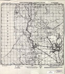
- Description:
- 1932
- Subject:
- Topical Subject: Maps, Geographic Subject: Shet district, and Topical Subject: Soviet Union
- Publisher:
- Главное управление государственной съемки и картографии НКВД СССР
- Language:
- Russian
- Date Created:
- 1938
- Identifier:
- VAC9619-002540
- Genre:
- Topographic Maps and Military Maps
- Geographic Location:
- Coordinates: 46.667, 73.5, 47, 74
- Related URL:
- Download GeoTIFF: https://drive.google.com/file/d/1yqXC6ldWLf-GiHEDmF9JIt2-KLB-xVzz/view?usp=sharing and Catalog URL: https://iucat.iu.edu/catalog/5020129
- Abstract:
- Modern area represented: Shet district, Karaganda oblast, Kazakhstan
- Call Number:
- G7000 s100 .S7 sheet L-43-40
- Copyright Holder:
- No Copyright - United States
- Country:
- СССР (USSR)
- State/Province:
- Четский район (Shet district) and Карагандинская область (Karaganda oblast)
- Physical Description:
- Scale: 1:100,000
- Persistent URL:
- http://purl.dlib.indiana.edu/iudl/images/VAC9619/VAC9619-002540
- Provenance:
- DMA Topographic Center, Library of Congress G & M Division, Army Map Service Library
-
- Description:
- 1932
- Subject:
- Topical Subject: Maps, Geographic Subject: Shet district, and Topical Subject: Soviet Union
- Publisher:
- Главное управление государственной съемки и картографии НКВД СССР
- Language:
- Russian
- Date Created:
- 1938
- Identifier:
- VAC9619-002539
- Genre:
- Military Maps and Topographic Maps
- Geographic Location:
- Coordinates: 46.667, 73, 47, 73.5
- Related URL:
- Catalog URL: https://iucat.iu.edu/catalog/5020129 and Download GeoTIFF: https://drive.google.com/file/d/1VFXA259FbiIixp0she4-S-AYr7CONug0/view?usp=sharing
- Abstract:
- Modern area represented: Shet district, Karaganda oblast, Kazakhstan
- Call Number:
- G7000 s100 .S7 sheet L-43-39
- Copyright Holder:
- No Copyright - United States
- Country:
- СССР (USSR)
- State/Province:
- Карагандинская область (Karaganda oblast) and Четский район (Shet district)
- Physical Description:
- Scale: 1:100,000
- Persistent URL:
- http://purl.dlib.indiana.edu/iudl/images/VAC9619/VAC9619-002539
- Provenance:
- DMA Topographic Center, Library of Congress G & M Division, Army Map Service Library, Auswärtiges Amt. Geographischer Dienst, OMAHA
-
- Description:
- 1932
- Subject:
- Topical Subject: Soviet Union, Geographic Subject: Shet district, and Topical Subject: Maps
- Publisher:
- Главное управление геодезии и картографии при СНК СССР
- Language:
- Russian
- Date Created:
- 1938
- Identifier:
- VAC9619-002538
- Genre:
- Military Maps and Topographic Maps
- Geographic Location:
- Coordinates: 47, 73, 47.333, 73.5
- Related URL:
- Download GeoTIFF: https://drive.google.com/file/d/1uXeGaN2zxNLtKfwoBfBpV2_ySLZ39Ola/view?usp=sharing and Catalog URL: https://iucat.iu.edu/catalog/5020129
- Abstract:
- Modern area represented: Shet district, Karaganda oblast, Kazakhstan
- Call Number:
- G7000 s100 .S7 sheet L-43-27
- Copyright Holder:
- No Copyright - United States
- Country:
- СССР (USSR)
- State/Province:
- Карагандинская область (Karaganda oblast) and Четский район (Shet district)
- Physical Description:
- Scale: 1:100,000
- Persistent URL:
- http://purl.dlib.indiana.edu/iudl/images/VAC9619/VAC9619-002538
- Provenance:
- DMA Topographic Center, Library of Congress G & M Division, Army Map Service Library, Auswärtiges Amt. Geographischer Dienst, OMAHA
-
- Description:
- 1934
- Subject:
- Topical Subject: Soviet Union, Topical Subject: Maps, and Geographic Subject: Aktogay district
- Publisher:
- Главное управление государственной съемки и картографии НКВД СССР
- Language:
- Russian
- Date Created:
- 1938
- Identifier:
- VAC9619-002537
- Genre:
- Military Maps and Topographic Maps
- Geographic Location:
- Coordinates: 47.333, 75, 47.667, 75.5
- Related URL:
- Download GeoTIFF: https://drive.google.com/file/d/1HvUN0cYNLD3PZs0CPw1JqQCCRNWdkeVH/view?usp=sharing and Catalog URL: https://iucat.iu.edu/catalog/5020129
- Abstract:
- Modern area represented: Aktogay district, Karaganda oblast, Kazakhstan
- Call Number:
- G7000 s100 .S7 sheet L-43-19
- Copyright Holder:
- No Copyright - United States
- Country:
- СССР (USSR)
- State/Province:
- Коунрадский район (Kounrad district) and Карагандинская область (Karaganda oblast)
- Physical Description:
- Scale: 1:100,000
- Persistent URL:
- http://purl.dlib.indiana.edu/iudl/images/VAC9619/VAC9619-002537
- Provenance:
- DMA Topographic Center, Library of Congress G & M Division, Army Map Service Library, Auswärtiges Amt. Geographischer Dienst, OMAHA
-
- Description:
- 1936
- Subject:
- Topical Subject: Soviet Union, Topical Subject: Maps, and Geographic Subject: Shet district
- Publisher:
- Главное управление геодезии и картографии при СНК СССР
- Language:
- Russian
- Date Created:
- 1938
- Identifier:
- VAC9619-002536
- Genre:
- Military Maps and Topographic Maps
- Geographic Location:
- Coordinates: 47.333, 73.5, 47.667, 74
- Related URL:
- Download GeoTIFF: https://drive.google.com/file/d/1y5IUZwmaLqyvAnApTOsei5GF9jgoacq1/view?usp=sharing and Catalog URL: https://iucat.iu.edu/catalog/5020129
- Abstract:
- Modern area represented: Shet district, Kazakhstan
- Call Number:
- G7000 s100 .S7 sheet L-43-16
- Copyright Holder:
- No Copyright - United States
- Country:
- СССР (USSR)
- State/Province:
- Четский район (Shet district) and Карагандинская область (Karaganda oblast)
- Physical Description:
- Scale: 1:100,000
- Persistent URL:
- http://purl.dlib.indiana.edu/iudl/images/VAC9619/VAC9619-002536
- Provenance:
- DMA Topographic Center, Library of Congress G & M Division, Army Map Service Library, Auswärtiges Amt. Geographischer Dienst
-
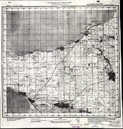
- Description:
- 1936
- Subject:
- Geographic Subject: Izobilniy, Topical Subject: Soviet Union, and Topical Subject: Maps
- Publisher:
- Главное управление геодезии и картографии при СНК СССР
- Language:
- Russian
- Date Created:
- 1938
- Identifier:
- VAC9619-002356
- Genre:
- Topographic Maps and Military Maps
- Geographic Location:
- Coordinates: 45.333, 41.5, 45.667, 42
- Related URL:
- Download GeoTIFF: https://drive.google.com/file/d/1vdDX-ouvmvAv4ARds6nqUHvSLaTrcMQP/view?usp=sharing and Catalog URL: https://iucat.iu.edu/catalog/5020129
- Abstract:
- Modern area represented: Izobilniy, Stavropol kray, Russia
- Call Number:
- G7000 s100 .S7 sheet L-37-96
- Caption:
- Для служебного пользования
- City:
- Изобильное (Izobilnoe)
- Copyright Holder:
- No Copyright - United States
- Country:
- СССР (USSR)
- State/Province:
- РСФСР (RSFSR) and Орджоникидзевский край (Ordzhonikidze kray)
- Physical Description:
- Scale: 1:100,000
- Persistent URL:
- http://purl.dlib.indiana.edu/iudl/images/VAC9619/VAC9619-002356
- Provenance:
- DMA Topographic Center, Army Map Service Library, OMAHA, Library of Congress Geography & Map Division
-
- Description:
- 1934
- Subject:
- Topical Subject: Maps, Topical Subject: Soviet Union, and Geographic Subject: Petrovskaya
- Publisher:
- Главное управление геодезии и картографии при СНК СССР
- Language:
- Russian
- Date Created:
- 1938
- Identifier:
- VAC9619-002347
- Genre:
- Topographic Maps and Military Maps
- Geographic Location:
- Coordinates: 45.333, 37.5, 45.667, 38
- Related URL:
- Catalog URL: https://iucat.iu.edu/catalog/5020129 and Download GeoTIFF: https://drive.google.com/file/d/1029Jux4cMhV7T-CDlD5yFWtEeQSL-8ab/view?usp=sharing
- Abstract:
- Modern area represented: Petrovskaya, Russia
- Call Number:
- G7000 s100 .S7 sheet L-37-88
- Caption:
- Для служебного пользования
- City:
- Петровская (Petrovskaya)
- Copyright Holder:
- No Copyright - United States
- Country:
- СССР (USSR)
- State/Province:
- РСФСР (RSFSR) and Краснодарский край (Krasnodar kray)
- Physical Description:
- Scale: 1:100,000
- Persistent URL:
- http://purl.dlib.indiana.edu/iudl/images/VAC9619/VAC9619-002347
- Provenance:
- CIA Map Library
-
- Description:
- 1935
- Subject:
- Topical Subject: Maps, Geographic Subject: Yeyskoye Ukrepleniye, and Topical Subject: Soviet Union
- Publisher:
- Генеральный штаб Красной Армии
- Language:
- Russian
- Date Created:
- 1938
- Identifier:
- VAC9619-002293
- Genre:
- Topographic Maps and Military Maps
- Geographic Location:
- Coordinates: 46.6667, 38.5, 47, 39
- Related URL:
- Catalog URL: https://iucat.iu.edu/catalog/5020129 and Download GeoTIFF: https://drive.google.com/file/d/1l8Y0gwYEf2tBKWG4raDsZHtB57IQK3rB/view?usp=sharing
- Abstract:
- Modern area represented: Yeyskoye Ukrepleniye, Krasnodar kray, Russia
- Call Number:
- G7000 s100 .S7 sheet L-37-42
- Caption:
- Для служебного пользования
- City:
- Ейское Укрепление (Yeyskoye Ukrepleniye)
- Copyright Holder:
- No Copyright - United States
- Country:
- СССР (USSR)
- State/Province:
- Краснодарский край (Krasnodar kray), РСФСР (RSFSR), and Ростовская область (Rostov oblast)
- Physical Description:
- Scale: 1:100,000
- Persistent URL:
- http://purl.dlib.indiana.edu/iudl/images/VAC9619/VAC9619-002293
- Provenance:
- CIA Map Library
