Indiana University
Indiana University
IU
Skip to Content
Digital Collections
Toggle navigation
Digital
Collections
Switch language
English
Switch language
Deutsch
English
Español
Français
Italiano
Português do Brasil
中文
Login
Home
About
Contact
Search Digital Collections
Go
×
Search Constraints
Start Over
You searched for:
Creator
Illinois State Geological Survey
Remove constraint Creator: Illinois State Geological Survey
« Previous |
1
-
10
of
24
|
Next »
Sort by relevance ▼
relevance ▼
recently updated
title ▲
title ▼
date created ▲
date created ▼
pages ▲
pages ▼
collection size ▲
collection size ▼
Number of results to display per page
10 per page
10
per page
20
per page
50
per page
100
per page
View results as:
List
Gallery
Masonry
Search Results
1.
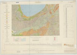
Geological map of the 1° x 2° Chicago Quadrangle, Indiana, Illinois, and Michigan, showing bedrock and unconsolidated deposits
2.
Indiana-Illinois, Vincennes quadrangle : topography [1944 printing without vegetation]
3.
Princeton quadrangle, Indiana-Illinois : 15 minute series (topographic) [1965 reprint with vegetation]
4.
Princeton quadrangle, Indiana-Illinois : 15 minute series (topographic) [1965 printing without vegetation]
5.
Indiana, 15 minute series (topographic), Vincennes quadrangle. [1915 printing with vegetation]
6.
Indiana-Illinois, Vincennes quadrangle : topography [1946 reprint with corrections and without vegetation]
7.
Indiana, 15 minute series (topographic), Vincennes quadrangle. [1934 reprint without vegetation]
8.
Illinois-Indiana, Ridge Farm quadrangle : 15-minute series [1947 printing]
9.
Princeton quadrangle, Indiana-Illinois : 15 minute series (topographic) [1965 reprint with vegetation]
10.
Princeton quadrangle, Indiana-Illinois : 15 minute series (topographic) [1964 printing with vegetation]
« Previous
Next »
1
2
3
Toggle facets
Limit your search
Type
Image
24
Creator
Illinois State Geological Survey
[remove]
24
Geological Survey (U.S.)
18
Herron, W. H. (William Harrison), 1865-
6
Marshall, R. B. (Robert Bradford), 1867-1949
6
U.S. Coast and Geodetic Survey
6
United States. Army Map Service
5
Indiana. Geological Survey
4
Tweedy, Frank, 1854-1937
4
United States. Army. Corps of Engineers
4
Lloyd, W. J. (Topographer)
3
more
Creators
»
Subject
Geographic Subject: Knox County (Ind.)
11
Geographic Subject: Gibson County (Ind.)
10
Topical Subject: Vegetation mapping
10
Geographic Subject: Wabash County (Ill.)
9
Geographic Subject: Crawford County (Ill.)
4
Geographic Subject: Illinois
4
Geographic Subject: Indiana
4
Geographic Subject: Lawrence County (Ill.)
4
Geographic Subject: Posey County (Ind.)
4
Geographic Subject: Sullivan County (Ind.)
4
more
Subjects
»
Publisher
Geological Survey (U.S.)
20
Indiana. Geological Survey
4
Date Created
1965
3
1943
2
1946
2
1964
2
1970
2
1915
1
1920
1
1924
1
1934
1
1944
1
more
Date Createds
»
Pages
0-99 pages
24
Collections
Indiana Historic Maps
24
State
deposited
24
Campus
IUB
24
Holding Location
B-WELLS
24
Provenance
Part of Geological Survey (U.S.). Indiana 1:62,500.
20
Indiana. Geological Survey. Regional geologic map , no. 1.
1
Indiana. Geological Survey. Regional geologic map , no. 2.
1
Indiana. Geological Survey. Regional geologic map , no. 3.
1
Indiana. Geological Survey. Regional geologic map , no. 4.
1

![Indiana-Illinois, Vincennes quadrangle : topography [1944 printing without vegetation]](https://iiif.uits.iu.edu/iiif/2/5425mf004%2Ffiles%2Fed25173c-f2ac-49e5-986c-99cf4220f9c3/full/250,/0/default.jpg)
![Princeton quadrangle, Indiana-Illinois : 15 minute series (topographic) [1965 reprint with vegetation]](https://iiif.uits.iu.edu/iiif/2/7m01cp47j%2Ffiles%2Fdc826735-24b7-4c3f-9d9b-87ad67efd7e8/full/250,/0/default.jpg)
![Princeton quadrangle, Indiana-Illinois : 15 minute series (topographic) [1965 printing without vegetation]](https://iiif.uits.iu.edu/iiif/2/70796d47m%2Ffiles%2Fedc5c6d4-9f41-4b7c-9447-a370bfe906e0/full/250,/0/default.jpg)
![Indiana, 15 minute series (topographic), Vincennes quadrangle. [1915 printing with vegetation]](https://iiif.uits.iu.edu/iiif/2/d791tm29s%2Ffiles%2F3ba9ccbe-8be1-48ce-9aac-c0c3b1eb0e6b/full/250,/0/default.jpg)
![Indiana-Illinois, Vincennes quadrangle : topography [1946 reprint with corrections and without vegetation]](https://iiif.uits.iu.edu/iiif/2/n009x521b%2Ffiles%2Fda21d6eb-ada6-4f1f-8c3c-8022f31eb1a9/full/250,/0/default.jpg)
![Indiana, 15 minute series (topographic), Vincennes quadrangle. [1934 reprint without vegetation]](https://iiif.uits.iu.edu/iiif/2/h702rb42n%2Ffiles%2Ff1e13118-9dbf-4ee1-a0ac-56cd2eb3a880/full/250,/0/default.jpg)
![Illinois-Indiana, Ridge Farm quadrangle : 15-minute series [1947 printing]](https://iiif.uits.iu.edu/iiif/2/s4656k47t%2Ffiles%2F1b742aea-c167-4972-8ac1-b0b7bb864c42/full/250,/0/default.jpg)
![Princeton quadrangle, Indiana-Illinois : 15 minute series (topographic) [1965 reprint with vegetation]](https://iiif.uits.iu.edu/iiif/2/sx61fr138%2Ffiles%2F603798b1-0337-482a-9bb7-934a41ad4b2b/full/250,/0/default.jpg)
![Princeton quadrangle, Indiana-Illinois : 15 minute series (topographic) [1964 printing with vegetation]](https://iiif.uits.iu.edu/iiif/2/m900px89p%2Ffiles%2Fe957c77d-db8c-42d6-aef0-05abd0d3301b/full/250,/0/default.jpg)