
Search Constraints
You searched for:
Publisher
Управление военных топографов РККА
Remove constraint Publisher: Управление военных топографов РККА
« Previous |
1 - 100 of 462
|
Next »
Search Results
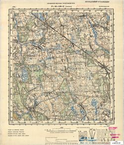
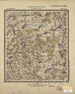
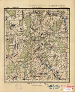
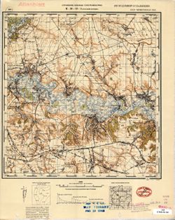
-
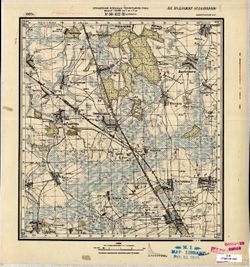
- Description:
- 1923
- Subject:
- Topical Subject: Maps, Geographic Subject: Yaromina, and Topical Subject: Soviet Union
- Publisher:
- Управление военных топографов РККА
- Language:
- Russian
- Identifier:
- VAC9619-001552
- Genre:
- Military Maps and Topographic Maps
- Geographic Location:
- Coordinates: 52.5, 30.75, 52.6667, 31
- Related URL:
- Download GeoTIFF: https://drive.google.com/open?id=1EwdH-g3Dx_6LD5AnhZVhdXQHoiUylwrg and Catalog URL: http://iucat.iu.edu/catalog/5020131
- Abstract:
- Modern area represented: Yaromina, Homyel oblast, Belarus
- Call Number:
- G7000 s50 .S68 sheet N-36-122-B
- Caption:
- Не подлежит оглашению
- City:
- Еремино (Yaromina)
- Copyright Holder:
- No Copyright - United States
- Country:
- СССР (USSR)
- State/Province:
- Белорусская ССР (Byelorussian Soviet Socialist Republic)
- Physical Description:
- Scale: 1:50,000
- Persistent URL:
- http://purl.dlib.indiana.edu/iudl/images/VAC9619/VAC9619-001552
- Provenance:
- M. I. Map Library, Atlasblatt
-

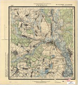
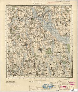
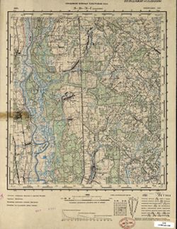
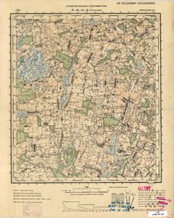
- Description:
- 1930
- Subject:
- Topical Subject: Soviet Union, Topical Subject: Maps, and Geographic Subject: Volodarsk
- Publisher:
- Управление военных топографов РККА
- Language:
- Russian
- Date Created:
- 1931
- Identifier:
- VAC9619-001550
- Genre:
- Military Maps and Topographic Maps
- Geographic Location:
- Coordinates: 52.3333, 30, 52.5, 30.25
- Related URL:
- Catalog URL: http://iucat.iu.edu/catalog/5020131 and Download GeoTIFF: https://drive.google.com/open?id=14iHQXU-g8T1RMvt81Kvfrqde3lXKwkh5
- Abstract:
- Modern area represented: Volodarsk, Homyel oblast, Belarus
- Call Number:
- G7000 s50 .S68 sheet N-36-121-C
- Caption:
- Не подлежит оглашению
- City:
- Гавеновичи (Gavenovichi)
- Copyright Holder:
- No Copyright - United States
- Country:
- СССР (USSR)
- State/Province:
- Белорусская ССР (Byelorussian Soviet Socialist Republic)
- Physical Description:
- Scale: 1:50,000
- Persistent URL:
- http://purl.dlib.indiana.edu/iudl/images/VAC9619/VAC9619-001550
- Provenance:
- Army Map Service Library, Library of Congress Geography & Map Division, OMAHA
-

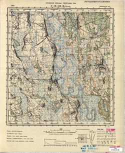
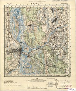
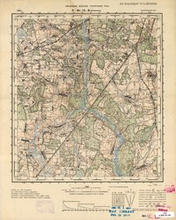
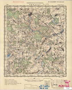
- Description:
- 1936
- Subject:
- Topical Subject: Maps, Topical Subject: Soviet Union, and Geographic Subject: Chebotovichi
- Publisher:
- Управление военных топографов РККА
- Language:
- Russian
- Identifier:
- VAC9619-001548
- Genre:
- Military Maps and Topographic Maps
- Geographic Location:
- Coordinates: 52.5, 30.25, 52.6667, 30.5
- Related URL:
- Download GeoTIFF: https://drive.google.com/open?id=1hEz-hZWO57SmZPvZbEaBzu7WJ1kcE6kz and Catalog URL: http://iucat.iu.edu/catalog/5020131
- Abstract:
- Modern area represented: Chebotovichi, Homyel oblast, Belarus
- Call Number:
- G7000 s50 .S68 sheet N-36-121-B
- Caption:
- Не подлежит оглашению
- City:
- Чеботовичи (Chebotovichi)
- Copyright Holder:
- No Copyright - United States
- Country:
- СССР (USSR)
- State/Province:
- Белорусская ССР (Byelorussian Soviet Socialist Republic)
- Physical Description:
- Scale: 1:50,000
- Persistent URL:
- http://purl.dlib.indiana.edu/iudl/images/VAC9619/VAC9619-001548
- Provenance:
- Army Map Service Library, Library of Congress Geography & Map Division, OMAHA
-

- Description:
- 1926
- Subject:
- Geographic Subject: Gorval, Topical Subject: Maps, and Topical Subject: Soviet Union
- Publisher:
- Управление военных топографов РККА
- Language:
- Russian
- Date Created:
- 1936
- Identifier:
- VAC9619-001547
- Genre:
- Military Maps and Topographic Maps
- Geographic Location:
- Coordinates: 52.5, 30, 52.6667, 30.25
- Related URL:
- Download GeoTIFF: https://drive.google.com/open?id=1SBp1cSyxbsOZzW87Z5z7xzVDLRHTxnom and Catalog URL: http://iucat.iu.edu/catalog/5020131
- Abstract:
- Modern area represented: Gorval, Homyel oblast, Belarus
- Call Number:
- G7000 s50 .S68 sheet N-36-121-A
- Caption:
- Не подлежит оглашению
- City:
- Горваль (Gorval)
- Copyright Holder:
- No Copyright - United States
- Country:
- СССР (USSR)
- State/Province:
- Белорусская ССР (Byelorussian Soviet Socialist Republic)
- Physical Description:
- Scale: 1:50,000
- Persistent URL:
- http://purl.dlib.indiana.edu/iudl/images/VAC9619/VAC9619-001547
- Provenance:
- Army Map Service Library, Library of Congress Geography & Map Division, OMAHA
-
- Description:
- 1928
- Subject:
- Topical Subject: Soviet Union, Geographic Subject: Lokot, and Topical Subject: Maps
- Publisher:
- Управление военных топографов РККА
- Language:
- Russian
- Identifier:
- VAC9619-001533
- Genre:
- Military Maps and Topographic Maps
- Geographic Location:
- Coordinates: 52.8667, 31, 53, 31.25
- Related URL:
- Download GeoTIFF: https://drive.google.com/open?id=1GxpBUovSd_cHLsCzQK6TDAseshOXH1ab and Catalog URL: http://iucat.iu.edu/catalog/5020131
- Abstract:
- Modern area represented: Lokot, Bryansk oblast, Russia
- Call Number:
- G7000 s50 .S68 sheet N-36-111-A
- Caption:
- Не подлежит оглашению
- City:
- Локоть (Lokot)
- Copyright Holder:
- No Copyright - United States
- Country:
- СССР (USSR)
- State/Province:
- Белорусская ССР (Byelorussian Soviet Socialist Republic)
- Physical Description:
- Scale: 1:50,000
- Persistent URL:
- http://purl.dlib.indiana.edu/iudl/images/VAC9619/VAC9619-001533
- Provenance:
- DMA Topographic Center, Army Map Service Library, OMAHA, Library of Congress Geography & Map Division
-
- Description:
- 1928
- Subject:
- Geographic Subject: Chachersk, Topical Subject: Soviet Union, and Topical Subject: Maps
- Publisher:
- Управление военных топографов РККА
- Language:
- Russian
- Identifier:
- VAC9619-001527
- Genre:
- Military Maps and Topographic Maps
- Geographic Location:
- Coordinates: 52.8667, 30.75, 53, 31
- Related URL:
- Download GeoTIFF: https://drive.google.com/open?id=1RPjzGng7eepaGYTUl-mzYLHkDbgHoeKH and Catalog URL: http://iucat.iu.edu/catalog/5020131
- Abstract:
- Modern area represented: Chachersk, Homyel oblast, Belarus
- Call Number:
- G7000 s50 .S68 sheet N-36-110-B
- Caption:
- Не подлежит оглашению
- City:
- Чечерск (Chachersk)
- Copyright Holder:
- No Copyright - United States
- Country:
- СССР (USSR)
- State/Province:
- Белорусская ССР (Byelorussian Soviet Socialist Republic)
- Physical Description:
- Scale: 1:50,000
- Persistent URL:
- http://purl.dlib.indiana.edu/iudl/images/VAC9619/VAC9619-001527
- Provenance:
- CIA Map Branch -- Received
-
- Description:
- 1936
- Subject:
- Topical Subject: Maps, Topical Subject: Soviet Union, and Geographic Subject: Streshin
- Publisher:
- Управление военных топографов РККА
- Language:
- Russian
- Identifier:
- VAC9619-001525
- Genre:
- Military Maps and Topographic Maps
- Geographic Location:
- Coordinates: 52.6667, 30, 52.8667, 30.25
- Related URL:
- Download GeoTIFF: https://drive.google.com/open?id=1POH65OMgnURYlMeEUDZP_BQqT3DVBuiW and Catalog URL: http://iucat.iu.edu/catalog/5020131
- Abstract:
- Modern area represented: Streshin, Homyel oblast, Belarus
- Call Number:
- G7000 s50 .S68 sheet N-36-109-В
- Caption:
- Не подлежит оглашению
- City:
- Стрешин (Streshin)
- Copyright Holder:
- No Copyright - United States
- Country:
- СССР (USSR)
- State/Province:
- Белорусская ССР (Byelorussian Soviet Socialist Republic)
- Physical Description:
- Scale: 1:50,000
- Persistent URL:
- http://purl.dlib.indiana.edu/iudl/images/VAC9619/VAC9619-001525
- Provenance:
- M. I. Map Library, G000-30, GS, RA
-
- Description:
- 1936
- Subject:
- Topical Subject: Maps, Topical Subject: Soviet Union, and Geographic Subject: Pirevichi
- Publisher:
- Управление военных топографов РККА
- Language:
- Russian
- Identifier:
- VAC9619-001526
- Genre:
- Military Maps and Topographic Maps
- Geographic Location:
- Coordinates: 52.6667, 30.25, 52.8667, 30.5
- Related URL:
- Catalog URL: http://iucat.iu.edu/catalog/5020131 and Download GeoTIFF: https://drive.google.com/open?id=1SuiL1h908k5bv94WoCYDQGl9cO2COwsi
- Abstract:
- Modern area represented: Pirevichi, Homyel oblast, Belarus
- Call Number:
- G7000 s50 .S68 sheet N-36-109-D
- Caption:
- Не подлежит оглашению
- City:
- Пиревичи (Pirevichi)
- Copyright Holder:
- No Copyright - United States
- Country:
- СССР (USSR)
- State/Province:
- Белорусская ССР (Byelorussian Soviet Socialist Republic)
- Physical Description:
- Scale: 1:50,000
- Persistent URL:
- http://purl.dlib.indiana.edu/iudl/images/VAC9619/VAC9619-001526
- Provenance:
- M. I. Map Library, G000-30, Atlasblatt
-
- Description:
- 1936
- Subject:
- Geographic Subject: Haradzyets, Topical Subject: Maps, and Topical Subject: Soviet Union
- Publisher:
- Управление военных топографов РККА
- Language:
- Russian
- Identifier:
- VAC9619-001524
- Genre:
- Military Maps and Topographic Maps
- Geographic Location:
- Coordinates: 52.8667, 30.25, 53, 30.5
- Related URL:
- Catalog URL: http://iucat.iu.edu/catalog/5020131 and Download GeoTIFF: https://drive.google.com/open?id=1VRkMyY6QsSsD6dvSqS6d99enfzkd3eZr
- Abstract:
- Modern area represented: Haradzyets, Homyel oblast, Belarus
- Call Number:
- G7000 s50 .S68 sheet N-36-109-B
- Caption:
- Не подлежит оглашению
- City:
- Городец (Haradzyets)
- Copyright Holder:
- No Copyright - United States
- Country:
- СССР (USSR)
- State/Province:
- Белорусская ССР (Byelorussian Soviet Socialist Republic)
- Physical Description:
- Scale: 1:50,000
- Persistent URL:
- http://purl.dlib.indiana.edu/iudl/images/VAC9619/VAC9619-001524
- Provenance:
- M. I. Map Library, Atlasblatt
-
- Description:
- 1931
- Subject:
- Geographic Subject: Zhlobin, Topical Subject: Soviet Union, and Topical Subject: Maps
- Publisher:
- Управление военных топографов РККА
- Language:
- Russian
- Date Created:
- 1936
- Identifier:
- VAC9619-001523
- Genre:
- Topographic Maps and Military Maps
- Geographic Location:
- Coordinates: 52.8667, 30, 53, 30.25
- Related URL:
- Download GeoTIFF: https://drive.google.com/open?id=1fegM38JGNEzEvDxv5geRA4ZAE-L4Nox_ and Catalog URL: http://iucat.iu.edu/catalog/5020131
- Abstract:
- Modern area represented: Zhlobin, Homyel oblast, Belarus
- Call Number:
- G7000 s50 .S68 sheet N-36-109-A
- Caption:
- Не подлежит оглашению
- City:
- Жлобин (Zhlobin)
- Copyright Holder:
- No Copyright - United States
- Country:
- СССР (USSR)
- State/Province:
- Белорусская ССР (Byelorussian Soviet Socialist Republic)
- Physical Description:
- Scale: 1:50,000
- Persistent URL:
- http://purl.dlib.indiana.edu/iudl/images/VAC9619/VAC9619-001523
- Provenance:
- CIA Map Branch -- Received
-
- Description:
- 1894
- Subject:
- Geographic Subject: Târgu Frumos, Topical Subject: Maps, and Topical Subject: Soviet Union
- Publisher:
- Управление военных топографов РККА
- Language:
- Russian
- Date Created:
- 1895
- Identifier:
- VAC9619-001513
- Genre:
- Topographic Maps and Military Maps
- Geographic Location:
- Coordinates: 47, 27, 47.3333, 27.5
- Related URL:
- Catalog URL: https://iucat.iu.edu/catalog/5020129 and Download GeoTIFF: https://drive.google.com/open?id=1LC0U4QZ-lg_KQMIgNHXryuR7uKbf-_vN
- Abstract:
- Modern area represented: Târgu Frumos, Iași county, Romania
- Call Number:
- G7000 s100 .S7 sheet L-35-31
- City:
- Тыргул Фрумос (Târgu Frumos)
- Copyright Holder:
- No Copyright - United States
- Country:
- Румыния (Romania)
- Physical Description:
- Scale: 1:100,000
- Persistent URL:
- http://purl.dlib.indiana.edu/iudl/images/VAC9619/VAC9619-001513
- Provenance:
- DMA Topographic Center, Army Map Service Library, Library of Congress Geography & Map Division
-
- Description:
- 1914
- Subject:
- Geographic Subject: Podilsk, Topical Subject: Maps, and Topical Subject: Soviet Union
- Publisher:
- Управление военных топографов РККА
- Language:
- Russian
- Date Created:
- 1932
- Identifier:
- VAC9619-001507
- Genre:
- Topographic Maps and Military Maps
- Geographic Location:
- Coordinates: 47.6667, 29.5, 48, 30
- Related URL:
- Download GeoTIFF: https://drive.google.com/file/d/1yoB4gIhyBxqMxVG2YSUt4dy0IT4GLUCb/view?usp=sharing and Catalog URL: https://iucat.iu.edu/catalog/5020129
- Abstract:
- Modern area represented: Podilsk, Odessa oblast, Ukraine
- Call Number:
- G7000 s100 .S7 sheet L-35-12
- Caption:
- Не подлежит оглашению
- City:
- Котовск (Kotovsk)
- Copyright Holder:
- No Copyright - United States
- Country:
- СССР (USSR)
- State/Province:
- Украинская ССР (Ukrainian Soviet Socialist Republic), Одесская область (Odessa oblast), and Молдавская АССР (Moldavian Autonomous Soviet Socialist Republic)
- Physical Description:
- Scale: 1:100,000
- Persistent URL:
- http://purl.dlib.indiana.edu/iudl/images/VAC9619/VAC9619-001507
- Provenance:
- DMA Topographic Center, Army Map Service Library, OMAHA, Library of Congress Geography & Map Division, Auswärtiges Amt. Geographischer Dienst
-
- Description:
- 1914
- Subject:
- Topical Subject: Maps, Topical Subject: Soviet Union, and Geographic Subject: Podilsk
- Publisher:
- Управление военных топографов РККА
- Language:
- Russian
- Date Created:
- 1932
- Identifier:
- VAC9619-001503
- Genre:
- Topographic Maps and Military Maps
- Geographic Location:
- Coordinates: 47.6667, 29.5, 48, 30
- Related URL:
- Catalog URL: https://iucat.iu.edu/catalog/5020129 and Download GeoTIFF: https://drive.google.com/open?id=1GY1T_2cRAKuBJomRz9ZEfhqJTuF0vfG8
- Abstract:
- Modern area represented: Podilsk, Odessa oblast, Ukraine
- Call Number:
- G7000 s100 .S7 sheet L-35-12
- Caption:
- Не подлежит оглашению
- City:
- Котовск (Kotovsk)
- Copyright Holder:
- No Copyright - United States
- Country:
- СССР (USSR)
- State/Province:
- Одесская область (Odessa oblast), Украинская ССР (Ukrainian Soviet Socialist Republic), and Молдавская АССР (Moldavian Autonomous Soviet Socialist Republic)
- Physical Description:
- Scale: 1:100,000
- Persistent URL:
- http://purl.dlib.indiana.edu/iudl/images/VAC9619/VAC9619-001503
- Provenance:
- CIA Map Library, Auswärtiges Amt. Geographischer Dienst
-
- Description:
- 1928
- Subject:
- Topical Subject: Maps, Topical Subject: Soviet Union, and Geographic Subject: Sidorovichi
- Publisher:
- Управление военных топографов РККА
- Language:
- Russian
- Identifier:
- VAC9619-001491
- Genre:
- Topographic Maps and Military Maps
- Geographic Location:
- Coordinates: 53, 31, 53.1667, 31.25
- Related URL:
- Download GeoTIFF: https://drive.google.com/open?id=14CtH2oyA5T83uZvToRCwUrheXc4a-Sp8 and Catalog URL: http://iucat.iu.edu/catalog/5020131
- Abstract:
- Modern area represented: Sidorovichi, Homyel oblast, Belarus
- Call Number:
- G7000 s50 .S68 sheet N-36-99-C
- Caption:
- Не подлежит оглашению
- City:
- Сидоровичи (Sidorovichi)
- Copyright Holder:
- No Copyright - United States
- Country:
- СССР (USSR)
- State/Province:
- Белорусская ССР (Byelorussian Soviet Socialist Republic)
- Physical Description:
- Scale: 1:50,000
- Persistent URL:
- http://purl.dlib.indiana.edu/iudl/images/VAC9619/VAC9619-001491
- Provenance:
- DMA Topographic Center, Army Map Service Library, OMAHA, Library of Congress Geography & Map Division
-
- Description:
- 1928
- Subject:
- Geographic Subject: Byerazyaki Pyershyya, Topical Subject: Maps, and Topical Subject: Soviet Union
- Publisher:
- Управление военных топографов РККА
- Language:
- Russian
- Identifier:
- VAC9619-001489
- Genre:
- Military Maps and Topographic Maps
- Geographic Location:
- Coordinates: 53.1667, 31, 53.3333, 31.25
- Related URL:
- Download GeoTIFF: https://drive.google.com/open?id=1DipC2Cg7TG5Yl2MoUucSxI-zQTjRu3Xt and Catalog URL: http://iucat.iu.edu/catalog/5020131
- Abstract:
- Modern area represented: Byerazyaki Pyershyya, Mogilev, Belarus
- Call Number:
- G7000 s50 .S68 sheet N-36-99-A
- Caption:
- Не подлежит оглашению
- City:
- Березяки (Berezyaki)
- Copyright Holder:
- No Copyright - United States
- Country:
- СССР (USSR)
- State/Province:
- Белорусская ССР (Byelorussian Soviet Socialist Republic)
- Physical Description:
- Scale: 1:50,000
- Persistent URL:
- http://purl.dlib.indiana.edu/iudl/images/VAC9619/VAC9619-001489
- Provenance:
- Army Map Service Library, Library of Congress Geography & Map Division, OMAHA
-
- Description:
- 1928
- Subject:
- Geographic Subject: Karma, Topical Subject: Soviet Union, and Topical Subject: Maps
- Publisher:
- Управление военных топографов РККА
- Language:
- Russian
- Identifier:
- VAC9619-001488
- Genre:
- Military Maps and Topographic Maps
- Geographic Location:
- Coordinates: 53, 30.75, 53.1667, 31
- Related URL:
- Catalog URL: http://iucat.iu.edu/catalog/5020131 and Download GeoTIFF: https://drive.google.com/open?id=1auewxECG5RQCc2MxiN6jXOxm43MRlEyj
- Abstract:
- Modern area represented: Karma, Homyel oblast, Belarus
- Call Number:
- G7000 s50 .S68 sheet N-36-98-D
- Caption:
- Не подлежит оглашению
- City:
- Корма (Korma)
- Copyright Holder:
- No Copyright - United States
- Country:
- СССР (USSR)
- State/Province:
- Белорусская ССР (Byelorussian Soviet Socialist Republic)
- Physical Description:
- Scale: 1:50,000
- Persistent URL:
- http://purl.dlib.indiana.edu/iudl/images/VAC9619/VAC9619-001488
- Provenance:
- DMA Topographic Center, Army Map Service Library, OMAHA, Library of Congress Geography & Map Division
-
- Description:
- 1926
- Subject:
- Geographic Subject: Zhuravichy, Topical Subject: Maps, and Topical Subject: Soviet Union
- Publisher:
- Управление военных топографов РККА
- Language:
- Russian
- Identifier:
- VAC9619-001486
- Genre:
- Topographic Maps and Military Maps
- Geographic Location:
- Coordinates: 53.1667, 30.5, 53.3333, 30.75
- Related URL:
- Catalog URL: http://iucat.iu.edu/catalog/5020131 and Download GeoTIFF: https://drive.google.com/open?id=1lUprQCQcIfCsvdXgirNCirw6aNhFuzMO
- Abstract:
- Modern area represented: Zhuravichy, Homyel oblast, Belarus
- Call Number:
- G7000 s50 .S68 sheet N-36-98-A
- Caption:
- Не подлежит оглашению
- City:
- Журавичи (Zhuravichy)
- Copyright Holder:
- No Copyright - United States
- Country:
- СССР (USSR)
- State/Province:
- Белорусская ССР (Byelorussian Soviet Socialist Republic)
- Physical Description:
- Scale: 1:50,000
- Persistent URL:
- http://purl.dlib.indiana.edu/iudl/images/VAC9619/VAC9619-001486
- Provenance:
- Army Map Service Library, Library of Congress Geography & Map Division, OMAHA
-
- Description:
- 1936
- Subject:
- Geographic Subject: Gadilovichi, Topical Subject: Maps, and Topical Subject: Soviet Union
- Publisher:
- Управление военных топографов РККА
- Language:
- Russian
- Identifier:
- VAC9619-001485
- Genre:
- Topographic Maps and Military Maps
- Geographic Location:
- Coordinates: 53, 30.25, 53.1667, 30.5
- Related URL:
- Catalog URL: http://iucat.iu.edu/catalog/5020131 and Download GeoTIFF: https://drive.google.com/open?id=1brXddhg0G6bGWPjqapYFWje60ePNOC1r
- Abstract:
- Modern area represented: Gadilovichi, Homyel oblast, Belarus
- Call Number:
- G7000 s50 .S68 sheet N-36-97-D
- Caption:
- Не подлежит оглашению
- City:
- Гадиловичи (Gadilovichi)
- Copyright Holder:
- No Copyright - United States
- Country:
- СССР (USSR)
- State/Province:
- Белорусская ССР (Byelorussian Soviet Socialist Republic)
- Physical Description:
- Scale: 1:50,000
- Persistent URL:
- http://purl.dlib.indiana.edu/iudl/images/VAC9619/VAC9619-001485
- Provenance:
- DMA Topographic Center, Army Map Service Library, OMAHA, Library of Congress Geography & Map Division
-
- Description:
- 1936
- Subject:
- Topical Subject: Soviet Union, Geographic Subject: Zvonets, and Topical Subject: Maps
- Publisher:
- Управление военных топографов РККА
- Language:
- Russian
- Identifier:
- VAC9619-001482
- Genre:
- Military Maps and Topographic Maps
- Geographic Location:
- Coordinates: 53.1667, 30.25, 53.3333, 30.5
- Related URL:
- Download GeoTIFF: https://drive.google.com/open?id=1r2DMZh2mjVq3AyPIe8qc-uOASC2UD_rt and Catalog URL: http://iucat.iu.edu/catalog/5020131
- Abstract:
- Modern area represented: Zvonets, Homyel oblast, Belarus
- Call Number:
- G7000 s50 .S68 sheet N-36-97-B
- Caption:
- Не подлежит оглашению
- City:
- Звонец (Zvonets)
- Copyright Holder:
- No Copyright - United States
- Country:
- СССР (USSR)
- State/Province:
- Белорусская ССР (Byelorussian Soviet Socialist Republic)
- Physical Description:
- Scale: 1:50,000
- Persistent URL:
- http://purl.dlib.indiana.edu/iudl/images/VAC9619/VAC9619-001482
- Provenance:
- DMA Topographic Center, Army Map Service Library, OMAHA, Library of Congress Geography & Map Division
-

- Description:
- 1936
- Subject:
- Topical Subject: Maps, Topical Subject: Soviet Union, and Geographic Subject: Toshchitsa
- Publisher:
- Управление военных топографов РККА
- Language:
- Russian
- Identifier:
- VAC9619-001483
- Genre:
- Topographic Maps and Military Maps
- Geographic Location:
- Coordinates: 53.1667, 30, 53.3333, 30.25
- Related URL:
- Download GeoTIFF: https://drive.google.com/open?id=1_FYtD0RS3xN9iUCIS0n9c-h7tZVOzuti and Catalog URL: http://iucat.iu.edu/catalog/5020131
- Abstract:
- Modern area represented: Toshchitsa, Mogilev, Belarus
- Call Number:
- G7000 s50 .S68 sheet N-36-97-A
- Caption:
- Не подлежит оглашению
- City:
- Тощица (Toshchitsa)
- Copyright Holder:
- No Copyright - United States
- Country:
- СССР (USSR)
- State/Province:
- Белорусская ССР (Byelorussian Soviet Socialist Republic)
- Physical Description:
- Scale: 1:50,000
- Persistent URL:
- http://purl.dlib.indiana.edu/iudl/images/VAC9619/VAC9619-001483
- Provenance:
- Army Map Service Library, Library of Congress Geography & Map Division, OMAHA
-
- Description:
- 1938
- Subject:
- Topical Subject: Soviet Union, Geographic Subject: Rahachow, and Topical Subject: Maps
- Publisher:
- Управление военных топографов РККА
- Language:
- Russian
- Identifier:
- VAC9619-001480
- Genre:
- Military Maps and Topographic Maps
- Geographic Location:
- Coordinates: 53, 30, 53.1667, 30.25
- Related URL:
- Catalog URL: http://iucat.iu.edu/catalog/5020131 and Download GeoTIFF: https://drive.google.com/open?id=1MFbzEarSW1uw7S4tQoMKJtGj4hkW7fHv
- Abstract:
- Modern area represented: Rahachow, Homyel oblast, Belarus
- Call Number:
- G7000 s50 .S68 sheet N-36-97-C
- Caption:
- Не подлежит оглашению
- City:
- Рогачев (Rahachow)
- Copyright Holder:
- No Copyright - United States
- Country:
- СССР (USSR)
- State/Province:
- Белорусская ССР (Byelorussian Soviet Socialist Republic)
- Physical Description:
- Scale: 1:50,000
- Persistent URL:
- http://purl.dlib.indiana.edu/iudl/images/VAC9619/VAC9619-001480
- Provenance:
- Army Map Service Library, Library of Congress Geography & Map Division, OMAHA
-
- Description:
- 1928
- Subject:
- Topical Subject: Soviet Union, Geographic Subject: Rzhavka, and Topical Subject: Maps
- Publisher:
- Управление военных топографов РККА
- Language:
- Russian
- Identifier:
- VAC9619-001439
- Genre:
- Topographic Maps and Military Maps
- Geographic Location:
- Coordinates: 53.3333, 30.75, 53.5, 31
- Related URL:
- Catalog URL: http://iucat.iu.edu/catalog/5020131 and Download GeoTIFF: https://drive.google.com/open?id=1DuHwcD1ih1-jlT7sJcCQxgPSmL1eQ0r0
- Abstract:
- Modern area represented: Rzhavka, Belarus
- Call Number:
- GM G7000 S50 .S68 N-36-86-Г
- Caption:
- Не подлежит оглашению
- City:
- Ржавка (Rzhavka)
- Copyright Holder:
- No Copyright - United States
- Country:
- СССР (USSR)
- State/Province:
- Белорусская ССР (Byelorussian Soviet Socialist Republic)
- Physical Description:
- Scale: 1:50,000
- Persistent URL:
- http://purl.dlib.indiana.edu/iudl/images/VAC9619/VAC9619-001439
- Provenance:
- DMA Topographic Center, Army Map Service Library, OMAHA, Library of Congress Geography & Map Division
-
- Description:
- 1928
- Subject:
- Geographic Subject: Rabovichi, Topical Subject: Soviet Union, and Topical Subject: Maps
- Publisher:
- Управление военных топографов РККА
- Language:
- Russian
- Identifier:
- VAC9619-001437
- Genre:
- Military Maps and Topographic Maps
- Geographic Location:
- Coordinates: 53.5, 30.75, 53.6667, 31
- Related URL:
- Download GeoTIFF: https://drive.google.com/open?id=1kevSVzLgjqK9itw71fxkheyN5ntxB-L6 and Catalog URL: http://iucat.iu.edu/catalog/5020131
- Abstract:
- Modern area represented: Rabovichi, Mogilev oblast, Belarus
- Call Number:
- GM G7000 S50 .S68 N-36-86-Б
- Caption:
- Не подлежит оглашению
- City:
- Рабовичи (Rabovichi)
- Copyright Holder:
- No Copyright - United States
- Country:
- СССР (USSR)
- State/Province:
- Белорусская ССР (Byelorussian Soviet Socialist Republic)
- Physical Description:
- Scale: 1:50,000
- Persistent URL:
- http://purl.dlib.indiana.edu/iudl/images/VAC9619/VAC9619-001437
- Provenance:
- DMA Topographic Center, Army Map Service Library, OMAHA, Library of Congress Geography & Map Division
-
- Description:
- 1936
- Subject:
- Topical Subject: Soviet Union, Geographic Subject: Noviy Bykhov, and Topical Subject: Maps
- Publisher:
- Управление военных топографов РККА
- Language:
- Russian
- Identifier:
- VAC9619-001435
- Genre:
- Military Maps and Topographic Maps
- Geographic Location:
- Coordinates: 53.3333, 30.25, 53.5, 30.5
- Related URL:
- Download GeoTIFF: https://drive.google.com/open?id=1YpmLZJo4Y9OsYLwcwKsyHhgGnXMUDjYr and Catalog URL: http://iucat.iu.edu/catalog/5020131
- Abstract:
- Modern area represented: Noviy Bykhov, Mogilev oblasst, Belarus
- Call Number:
- GM G7000 S50 .S68 N-36-85-Г
- Caption:
- Не подлежит оглашению
- City:
- Нов.Быхов (Noviy Bykhov)
- Copyright Holder:
- No Copyright - United States
- Country:
- СССР (USSR)
- State/Province:
- Белорусская ССР (Byelorussian Soviet Socialist Republic)
- Physical Description:
- Scale: 1:50,000
- Persistent URL:
- http://purl.dlib.indiana.edu/iudl/images/VAC9619/VAC9619-001435
- Provenance:
- DMA Topographic Center, Army Map Service Library, OMAHA, Library of Congress Geography & Map Division
-
- Description:
- 1936
- Subject:
- Geographic Subject: Ludchytsy, Topical Subject: Maps, and Topical Subject: Soviet Union
- Publisher:
- Управление военных топографов РККА
- Language:
- Russian
- Identifier:
- VAC9619-001434
- Genre:
- Military Maps and Topographic Maps
- Geographic Location:
- Coordinates: 53.3333, 30, 53.5, 30.25
- Related URL:
- Catalog URL: http://iucat.iu.edu/catalog/5020131 and Download GeoTIFF: https://drive.google.com/open?id=1bj1iFsVPR0DCUs139aNWM1VgtHomgrCh
- Abstract:
- Modern area represented: Ludchytsy, Mogilev oblast, Belarus
- Call Number:
- GM G7000 S50 .S68 N-36-85-C
- Caption:
- Не подлежит оглашению
- City:
- Лудчица (Ludchytsy)
- Copyright Holder:
- No Copyright - United States
- Country:
- СССР (USSR)
- State/Province:
- Белорусская ССР (Byelorussian Soviet Socialist Republic)
- Physical Description:
- Scale: 1:50,000
- Persistent URL:
- http://purl.dlib.indiana.edu/iudl/images/VAC9619/VAC9619-001434
- Provenance:
- DMA Topographic Center, Army Map Service Library, OMAHA, Library of Congress Geography & Map Division
-
- Description:
- 1936
- Subject:
- Topical Subject: Soviet Union, Topical Subject: Maps, and Geographic Subject: Mokroye
- Publisher:
- Управление военных топографов РККА
- Language:
- Russian
- Identifier:
- VAC9619-001432
- Genre:
- Topographic Maps and Military Maps
- Geographic Location:
- Coordinates: 53.5, 30, 53.6667, 30.25
- Related URL:
- Download GeoTIFF: https://drive.google.com/open?id=1zKP_AP6w61BUYEJWfVOfsyeYbLW1ZAZ- and Catalog URL: http://iucat.iu.edu/catalog/5020131
- Abstract:
- Modern area represented: Mokroye, Mogilev oblast, Belarus
- Call Number:
- GM G7000 S50 .S68 N-36-85-A
- Caption:
- Не подлежит оглашению
- City:
- Мокрое (Mokroye)
- Copyright Holder:
- No Copyright - United States
- Country:
- СССР (USSR)
- State/Province:
- Белорусская ССР (Byelorussian Soviet Socialist Republic)
- Physical Description:
- Scale: 1:50,000
- Persistent URL:
- http://purl.dlib.indiana.edu/iudl/images/VAC9619/VAC9619-001432
- Provenance:
- DMA Topographic Center, Army Map Service Library, OMAHA, Library of Congress Geography & Map Division
-
- Description:
- 1928
- Subject:
- Topical Subject: Soviet Union, Topical Subject: Maps, and Geographic Subject: Gubinshchina
- Publisher:
- Управление военных топографов РККА
- Language:
- Russian
- Identifier:
- VAC9619-001405
- Genre:
- Military Maps and Topographic Maps
- Geographic Location:
- Coordinates: 53.667, 31.25, 53.833, 31.5
- Related URL:
- Download GeoTIFF: https://drive.google.com/open?id=1FfCYB1nIHIlZ1jVTEZ7WWXl6WsO3i5Nb and Catalog URL: http://iucat.iu.edu/catalog/5020131
- Abstract:
- Modern area represented: Gubinshchina, Mogilev oblast, Belarus
- Call Number:
- GM G7000 S50 .S68 N-36-75-Г
- Caption:
- Не подлежит оглашению
- City:
- Губенщина (Gubinshchina)
- Copyright Holder:
- No Copyright - United States
- Country:
- СССР (USSR)
- State/Province:
- Белорусская ССР (Byelorussian Soviet Socialist Republic)
- Physical Description:
- Scale: 1:50,000
- Persistent URL:
- http://purl.dlib.indiana.edu/iudl/images/VAC9619/VAC9619-001405
- Provenance:
- DMA Topographic Center, Army Map Service Library, OMAHA, Library of Congress Geography & Map Division
-
- Description:
- 1923
- Subject:
- Geographic Subject: Blagovichi, Topical Subject: Soviet Union, and Topical Subject: Maps
- Publisher:
- Управление военных топографов РККА
- Language:
- Russian
- Identifier:
- VAC9619-001400
- Genre:
- Military Maps and Topographic Maps
- Geographic Location:
- Coordinates: 53.883, 30.75, 54, 31
- Related URL:
- Catalog URL: http://iucat.iu.edu/catalog/5020131 and Download GeoTIFF: https://drive.google.com/open?id=1eiadXmLwaEhWybKU439VJC33Y76Dz8bl
- Abstract:
- Modern area represented: Blagovichi, Mogilev oblast, Belarus
- Call Number:
- GM G7000 S50 .S68 N-36-74-Б
- Caption:
- Не подлежит оглашению
- City:
- Благовичи (Blagovichi)
- Copyright Holder:
- No Copyright - United States
- Country:
- СССР (USSR)
- State/Province:
- Белорусская ССР (Byelorussian Soviet Socialist Republic)
- Physical Description:
- Scale: 1:50,000
- Persistent URL:
- http://purl.dlib.indiana.edu/iudl/images/VAC9619/VAC9619-001400
- Provenance:
- Library of Congress Geography & Map Division, Army Map Service Library, OMAHA
-
- Description:
- 1923
- Subject:
- Geographic Subject: Sukhary, Topical Subject: Maps, and Topical Subject: Soviet Union
- Publisher:
- Управление военных топографов РККА
- Language:
- Russian
- Date Created:
- 1924
- Identifier:
- VAC9619-001399
- Genre:
- Military Maps and Topographic Maps
- Geographic Location:
- Coordinates: 53.833, 30.5, 54, 30.75
- Related URL:
- Download GeoTIFF: https://drive.google.com/open?id=1dumq5lt2DDdAgLvoJZ0PcqZZMRlFZDzp and Catalog URL: http://iucat.iu.edu/catalog/5020131
- Abstract:
- Modern area represented: Sukhary, Mogilev oblast, Belarus
- Call Number:
- GM G7000 S50 .S68 N-36-74-A
- Caption:
- Не подлежит оглашению
- City:
- Сухари (Sukhary)
- Copyright Holder:
- No Copyright - United States
- Country:
- СССР (USSR)
- State/Province:
- Белорусская ССР (Byelorussian Soviet Socialist Republic)
- Physical Description:
- Scale: 1:50,000
- Persistent URL:
- http://purl.dlib.indiana.edu/iudl/images/VAC9619/VAC9619-001399
- Provenance:
- Library of Congress Geography & Map Division
-
- Description:
- 1936
- Subject:
- Geographic Subject: Dashkovka, Topical Subject: Soviet Union, and Topical Subject: Maps
- Publisher:
- Управление военных топографов РККА
- Language:
- Russian
- Identifier:
- VAC9619-001398
- Genre:
- Military Maps and Topographic Maps
- Geographic Location:
- Coordinates: 53.667, 30.25, 53.833, 30.5
- Related URL:
- Catalog URL: http://iucat.iu.edu/catalog/5020131 and Download GeoTIFF: https://drive.google.com/open?id=1QaWQy23l6FtxRyK2BJ9gQoxvKzTP6cMf
- Abstract:
- Modern area represented: Dashkovka, Mogilev oblast, Belarus
- Call Number:
- GM G7000 S50 .S68 N-36-73-Г
- Caption:
- Не подлежит оглашению
- City:
- Дашковка (Dashkovka)
- Copyright Holder:
- No Copyright - United States
- Country:
- СССР (USSR)
- State/Province:
- Белорусская ССР (Byelorussian Soviet Socialist Republic)
- Physical Description:
- Scale: 1:50,000
- Persistent URL:
- http://purl.dlib.indiana.edu/iudl/images/VAC9619/VAC9619-001398
- Provenance:
- Library of Congress Geography & Map Division
-
- Description:
- 1936
- Subject:
- Topical Subject: Maps, Topical Subject: Soviet Union, and Geographic Subject: Mezhisyatki
- Publisher:
- Управление военных топографов РККА
- Language:
- Russian
- Identifier:
- VAC9619-001397
- Genre:
- Military Maps and Topographic Maps
- Geographic Location:
- Coordinates: 53.667, 30, 53.833, 30.25
- Related URL:
- Download GeoTIFF: https://drive.google.com/open?id=1bYNukxBy97BrCwOss3GOlRRA984CXkOZ and Catalog URL: http://iucat.iu.edu/catalog/5020131
- Abstract:
- Modern area represented: Mezhisyatki, Mogilev oblast, Belarus
- Call Number:
- GM G7000 S50 .S68 N-36-73-B
- Caption:
- Не подлежит оглашению
- City:
- Межисятки (Mezhisyatki)
- Copyright Holder:
- No Copyright - United States
- Country:
- СССР (USSR)
- State/Province:
- Белорусская ССР (Byelorussian Soviet Socialist Republic)
- Physical Description:
- Scale: 1:50,000
- Persistent URL:
- http://purl.dlib.indiana.edu/iudl/images/VAC9619/VAC9619-001397
- Provenance:
- M. I. Map Library, GS, RA
-
- Description:
- 1936
- Subject:
- Topical Subject: Soviet Union, Geographic Subject: Knyazhitsy, and Topical Subject: Maps
- Publisher:
- Управление военных топографов РККА
- Language:
- Russian
- Identifier:
- VAC9619-001395
- Genre:
- Military Maps and Topographic Maps
- Geographic Location:
- Coordinates: 53.833, 30, 54, 30.25
- Related URL:
- Catalog URL: http://iucat.iu.edu/catalog/5020131 and Download GeoTIFF: https://drive.google.com/open?id=1Xy_l5e1nJrocil-Mj55vvGuSXu6ykorV
- Abstract:
- Modern area represented: Knyazhitsy, Mogilev oblast, Belarus
- Call Number:
- GM G7000 S50 .S68 N-36-73-A
- Caption:
- Не подлежит оглашению
- City:
- Княжицы (Knyazhitsy)
- Copyright Holder:
- No Copyright - United States
- Country:
- СССР (USSR)
- State/Province:
- Белорусская ССР (Byelorussian Soviet Socialist Republic)
- Physical Description:
- Scale: 1:50,000
- Persistent URL:
- http://purl.dlib.indiana.edu/iudl/images/VAC9619/VAC9619-001395
- Provenance:
- DMA Topographic Center, Army Map Service Library, OMAHA, M. I. Map Library
-
- Description:
- 1923
- Subject:
- Geographic Subject: Ordat, Topical Subject: Maps, and Topical Subject: Soviet Union
- Publisher:
- Управление военных топографов РККА
- Language:
- Russian
- Date Created:
- 1924
- Identifier:
- VAC9619-001365
- Genre:
- Military Maps and Topographic Maps
- Geographic Location:
- Coordinates: 54, 30.5, 54.167, 30.75
- Related URL:
- Catalog URL: http://iucat.iu.edu/catalog/5020131 and Download GeoTIFF: https://drive.google.com/open?id=1jxqpK4WxNHZB4VFSzNUlIzIBL707SBkY
- Abstract:
- Modern area represented: Ordat, Mogilev oblast, Belarus
- Call Number:
- GM G7000 S50 .S68 N-36-62-B
- Caption:
- Не подлежит оглашению
- City:
- Ордат (Ordat)
- Copyright Holder:
- No Copyright - United States
- Country:
- СССР (USSR)
- State/Province:
- Белорусская ССР (Byelorussian Soviet Socialist Republic)
- Physical Description:
- Scale: 1:50,000
- Persistent URL:
- http://purl.dlib.indiana.edu/iudl/images/VAC9619/VAC9619-001365
- Provenance:
- M. I. Map Library, Reichsamt für Landesaufnahme, Kartensammlung
-
- Description:
- 1936
- Subject:
- Geographic Subject: Staraya Vodva, Topical Subject: Soviet Union, and Topical Subject: Maps
- Publisher:
- Управление военных топографов РККА
- Language:
- Russian
- Identifier:
- VAC9619-001360
- Genre:
- Military Maps and Topographic Maps
- Geographic Location:
- Coordinates: 54, 30, 54.1667, 30.25
- Related URL:
- Catalog URL: http://iucat.iu.edu/catalog/5020131 and Download GeoTIFF: https://drive.google.com/open?id=1UJgOmQFinMKTGb94FAm3yjvFTA510yVz
- Abstract:
- Modern area represented: Staraya Vodva, Mogilev oblast, Belarus
- Call Number:
- GM G7000 S50 .S68 N-36-61-B
- Caption:
- Не подлежит оглашению
- City:
- Старая Водва (Staraya Vodva)
- Copyright Holder:
- No Copyright - United States
- Country:
- СССР (USSR)
- State/Province:
- Белорусская ССР (Byelorussian Soviet Socialist Republic)
- Physical Description:
- Scale: 1:50,000
- Persistent URL:
- http://purl.dlib.indiana.edu/iudl/images/VAC9619/VAC9619-001360
- Provenance:
- M. I. Map Library, Reichsamt für Landesaufnahme, Kartensammlung, GS, RA
-
- Description:
- 1936
- Subject:
- Topical Subject: Soviet Union, Geographic Subject: Staroselje, and Topical Subject: Maps
- Publisher:
- Управление военных топографов РККА
- Language:
- Russian
- Identifier:
- VAC9619-001358
- Genre:
- Topographic Maps and Military Maps
- Geographic Location:
- Coordinates: 54.167, 30, 54.333, 30.25
- Related URL:
- Download GeoTIFF: https://drive.google.com/open?id=1mJQEPtRDCi4mtsWY57pbOdHfup0Eoz4T and Catalog URL: http://iucat.iu.edu/catalog/5020131
- Abstract:
- Modern area represented: Staroselje, Mogilev oblast, Belarus
- Call Number:
- GM G7000 S50 .S68 N-36-61-A
- Caption:
- Не подлежит оглашению
- City:
- Староселье (Staroselje)
- Copyright Holder:
- No Copyright - United States
- Country:
- СССР (USSR)
- State/Province:
- Белорусская ССР (Byelorussian Soviet Socialist Republic)
- Physical Description:
- Scale: 1:50,000
- Persistent URL:
- http://purl.dlib.indiana.edu/iudl/images/VAC9619/VAC9619-001358
- Provenance:
- M. I. Map Library, Atlasblatt, GS, RA
-

- Description:
- 1936
- Subject:
- Topical Subject: Soviet Union, Geographic Subject: Lisuny, and Topical Subject: Maps
- Publisher:
- Управление военных топографов РККА
- Language:
- Russian
- Identifier:
- VAC9619-001321
- Genre:
- Topographic Maps and Military Maps
- Geographic Location:
- Coordinates: 54.3333, 30, 54.5, 30.25
- Related URL:
- Catalog URL: http://iucat.iu.edu/catalog/5020131 and Download GeoTIFF: https://drive.google.com/open?id=1EmzdF05lkAsUaxBzv0M0VihEUALrtEl3
- Abstract:
- Modern area represented: Lisuny, Vitebsk oblast, Belarus
- Call Number:
- GM G7000 S50 .S68 N-36-49-C
- Caption:
- Не подлежит оглашению
- City:
- Лисуны (Lisuny)
- Copyright Holder:
- No Copyright - United States
- Country:
- СССР (USSR)
- State/Province:
- Белорусская ССР (Byelorussian Soviet Socialist Republic)
- Physical Description:
- Scale: 1:50,000
- Persistent URL:
- http://purl.dlib.indiana.edu/iudl/images/VAC9619/VAC9619-001321
- Provenance:
- Army Map Service Library, Library of Congress Geography & Map Division, OMAHA
-

- Description:
- 1936
- Subject:
- Topical Subject: Maps, Topical Subject: Soviet Union, and Geographic Subject: Smolyany
- Publisher:
- Управление военных топографов РККА
- Language:
- Russian
- Identifier:
- VAC9619-001319
- Genre:
- Military Maps and Topographic Maps
- Geographic Location:
- Coordinates: 54.5, 30, 54.667, 30.25
- Related URL:
- Download GeoTIFF: https://drive.google.com/open?id=1upcBNDdtQUyNlOUnLC75D8vzcFQ-JDW4 and Catalog URL: http://iucat.iu.edu/catalog/5020131
- Abstract:
- Modern area represented: Smolyany, Vitebsk oblast, Belarus
- Call Number:
- GM G7000 S50 .S68 N-36-49-A
- Caption:
- Не подлежит оглашению
- City:
- Смоляны (Smolyany)
- Copyright Holder:
- No Copyright - United States
- Country:
- СССР (USSR)
- State/Province:
- Белорусская ССР (Byelorussian Soviet Socialist Republic)
- Physical Description:
- Scale: 1:50,000
- Persistent URL:
- http://purl.dlib.indiana.edu/iudl/images/VAC9619/VAC9619-001319
- Provenance:
- Army Map Service Library, Library of Congress Geography & Map Division, OMAHA
-
- Description:
- 1931
- Subject:
- Topical Subject: Maps, Geographic Subject: Yabluneve, and Topical Subject: Soviet Union
- Publisher:
- Управление военных топографов РККА
- Language:
- Russian
- Identifier:
- VAC9619-000995
- Genre:
- Military Maps and Topographic Maps
- Geographic Location:
- Coordinates: 49.833, 32.5, 50, 32.75
- Related URL:
- Catalog URL: http://iucat.iu.edu/catalog/5020131 and Download GeoTIFF: https://drive.google.com/open?id=1Y0U1rP6HMNXJRoGBOJE68UazBq6Cbota
- Abstract:
- Modern area represented: Яблуневе (Yabluneve), Poltava oblast, Ukraine
- Call Number:
- G7000 s50 .S68 sheet M-36-78-A
- Caption:
- Не подлежит оглашению
- City:
- Яблонево (Yablonevo)
- Copyright Holder:
- No Copyright - United States
- Country:
- СССР (USSR)
- State/Province:
- Украинская ССР (Ukrainian Soviet Socialist Republic) and Харьковская область (Kharkiv oblast)
- Physical Description:
- Scale: 1:50,000
- Persistent URL:
- http://purl.dlib.indiana.edu/iudl/images/VAC9619/VAC9619-000995
- Provenance:
- DMA Topographic Center, Army Map Service Library, OMAHA, Library of Congress Geography & Map Division
-
- Description:
- 1929
- Subject:
- Topical Subject: Soviet Union, Geographic Subject: Khots'ky, and Topical Subject: Maps
- Publisher:
- Управление военных топографов РККА
- Language:
- Russian
- Identifier:
- VAC9619-000990
- Genre:
- Topographic Maps and Military Maps
- Geographic Location:
- Coordinates: 49.833, 31.5, 50, 31.75
- Related URL:
- Download GeoTIFF: https://drive.google.com/open?id=1jB5JfK3SAXo-sey_DbYZFJCLlYwvPN2J and Catalog URL: http://iucat.iu.edu/catalog/5020131
- Abstract:
- Modern area represented: Хоцьки (Khots'ky), Kyiv oblast, Ukraine
- Call Number:
- G7000 s50 .S68 sheet M-36-76-A
- Caption:
- Captured map, Рассекречено, and Не подлежит оглашению (crossed out)
- City:
- Хоцки (Khotski)
- Copyright Holder:
- No Copyright - United States
- Country:
- СССР (USSR)
- State/Province:
- Киевская область (Kyiv oblast) and Украинская ССР (Ukrainian Soviet Socialist Republic)
- Physical Description:
- Scale: 1:50,000
- Persistent URL:
- http://purl.dlib.indiana.edu/iudl/images/VAC9619/VAC9619-000990
- Provenance:
- DMA Topographic Center, Army Map Service Library, Library of Congress Geography & Map Division
-
- Description:
- 1923
- Subject:
- Topical Subject: Soviet Union, Geographic Subject: Teleshivka, and Topical Subject: Maps
- Publisher:
- Управление военных топографов РККА
- Language:
- Russian
- Identifier:
- VAC9619-000988
- Genre:
- Topographic Maps and Military Maps
- Geographic Location:
- Coordinates: 49.667, 30.5, 49.833, 30.75
- Related URL:
- Catalog URL: http://iucat.iu.edu/catalog/5020131 and Download GeoTIFF: https://drive.google.com/open?id=1plY_Gwa6G_xViG2BZOj9WjR0V4AyVA1i
- Abstract:
- Modern area represented: Телешівка (Teleshivka), Kyiv oblast, Ukraine
- Call Number:
- G7000 s50 .S68 sheet M-36-74-C
- Caption:
- Не подлежит оглашению
- City:
- Телешовка (Teleshovka)
- Copyright Holder:
- No Copyright - United States
- Country:
- СССР (USSR)
- State/Province:
- Украинская ССР (Ukrainian Soviet Socialist Republic) and Киевская область (Kyiv oblast)
- Physical Description:
- Scale: 1:50,000
- Persistent URL:
- http://purl.dlib.indiana.edu/iudl/images/VAC9619/VAC9619-000988
- Provenance:
- M. I. Map Library, Library of Congress Geography & Map Division
-
- Subject:
- Topical Subject: Soviet Union, Geographic Subject: Kaharlyk, and Topical Subject: Maps
- Publisher:
- Управление военных топографов РККА
- Language:
- Russian
- Identifier:
- VAC9619-000987
- Genre:
- Topographic Maps and Military Maps
- Geographic Location:
- Coordinates: 49.833, 30.75, 50, 31
- Related URL:
- Catalog URL: http://iucat.iu.edu/catalog/5020131 and Download GeoTIFF: https://drive.google.com/open?id=1j-kE_J-SY02vADijGiMpPrpwQivq-pDV
- Abstract:
- Modern area represented: Кагарлик (Kaharlyk), Kyiv oblast, Ukraine
- Call Number:
- G7000 s50 .S68 sheet M-36-61-G
- Caption:
- Не подлежит оглашению
- City:
- Кагарлык (Kagarlyk)
- Copyright Holder:
- No Copyright - United States
- Country:
- СССР (USSR)
- State/Province:
- Киевская область (Kyiv oblast) and Украинская ССР (Ukrainian Soviet Socialist Republic)
- Physical Description:
- Scale: 1:50,000
- Persistent URL:
- http://purl.dlib.indiana.edu/iudl/images/VAC9619/VAC9619-000987
- Provenance:
- DMA Topographic Center, Army Map Service Library, OMAHA, Library of Congress Geography & Map Division
-
- Description:
- 1931
- Subject:
- Topical Subject: Soviet Union, Topical Subject: Maps, and Geographic Subject: Komyshnya
- Publisher:
- Управление военных топографов РККА
- Language:
- Russian
- Identifier:
- VAC9619-000981
- Genre:
- Topographic Maps and Military Maps
- Geographic Location:
- Coordinates: 50.167, 33.5, 50.333, 33.75
- Related URL:
- Catalog URL: http://iucat.iu.edu/catalog/5020131 and Download GeoTIFF: https://drive.google.com/open?id=1EdkumY4aAZH5DM7GyxUVyTTDfdMIBHRF
- Abstract:
- Modern area represented: Комишня (Komyshnya), Poltava oblast, Ukraine
- Call Number:
- G7000 s50 .S68 sheet M-36-6-A
- Caption:
- Не подлежит оглашению
- City:
- Комышно (Komyshno)
- Copyright Holder:
- No Copyright - United States
- Country:
- СССР (USSR)
- State/Province:
- Харьковская область (Kharkiv oblast) and Украинская ССР (Ukrainian Soviet Socialist Republic)
- Physical Description:
- Scale: 1:50,000
- Persistent URL:
- http://purl.dlib.indiana.edu/iudl/images/VAC9619/VAC9619-000981
- Provenance:
- DMA Topographic Center, Army Map Service Library, OMAHA, Library of Congress Geography & Map Division
-
- Description:
- 1923
- Subject:
- Geographic Subject: Stare, Topical Subject: Maps, and Topical Subject: Soviet Union
- Publisher:
- Управление военных топографов РККА
- Language:
- Russian
- Identifier:
- VAC9619-000976
- Genre:
- Topographic Maps and Military Maps
- Geographic Location:
- Coordinates: 50, 31, 50.167, 31.25
- Related URL:
- Catalog URL: http://iucat.iu.edu/catalog/5020131 and Download GeoTIFF: https://drive.google.com/open?id=1Kck6RTXHnYIdUwDRIb7nOnDUWuOS_qDU
- Abstract:
- Modern area represented: Старе (Stare), Kyiv oblast, Ukraine
- Call Number:
- G7000 s50 .S68 sheet M-36-63-C
- Caption:
- Не подлежит оглашению
- City:
- Старое (Staroye)
- Copyright Holder:
- No Copyright - United States
- Country:
- СССР (USSR)
- State/Province:
- Киевская область (Kyiv oblast) and Украинская ССР (Ukrainian Soviet Socialist Republic)
- Physical Description:
- Scale: 1:50,000
- Persistent URL:
- http://purl.dlib.indiana.edu/iudl/images/VAC9619/VAC9619-000976
- Provenance:
- M. I. Map Library, Library of Congress Geography & Map Division
-
- Subject:
- Geographic Subject: Obukhiv, Topical Subject: Soviet Union, and Topical Subject: Maps
- Publisher:
- Управление военных топографов РККА
- Language:
- Russian
- Identifier:
- VAC9619-000974
- Genre:
- Topographic Maps and Military Maps
- Geographic Location:
- Coordinates: 50.0, 30.5, 50.16667, 30.75
- Related URL:
- Catalog URL: http://iucat.iu.edu/catalog/5020131 and Download GeoTIFF: https://drive.google.com/open?id=1rx5Y79bSm-lRlIZDJAYvSzJEywJteG9a
- Abstract:
- Modern area represented: Обухів (Obukhiv), Kyiv oblast, Ukraine
- Call Number:
- G7000 s50 .S68 sheet M-36-62-B
- Caption:
- Не подлежит оглашению
- City:
- Обухов (Obukhov)
- Copyright Holder:
- No Copyright - United States
- Country:
- СССР (USSR)
- State/Province:
- Киевская область (Kyiv oblast) and Украинская ССР (Ukrainian Soviet Socialist Republic)
- Physical Description:
- Scale: 1:50,000
- Persistent URL:
- http://purl.dlib.indiana.edu/iudl/images/VAC9619/VAC9619-000974
- Provenance:
- DMA Topographic Center, Army Map Service Library, OMAHA, Library of Congress Geography & Map Division
-
- Subject:
- Topical Subject: Soviet Union, Geographic Subject: Barakhty, and Topical Subject: Maps
- Publisher:
- Управление военных топографов РККА
- Language:
- Russian
- Identifier:
- VAC9619-000971
- Genre:
- Military Maps and Topographic Maps
- Geographic Location:
- Coordinates: 50.0, 30.25, 50.166667, 30.5
- Related URL:
- Download GeoTIFF: https://drive.google.com/open?id=1P1R6u7ZLUoz9PA2JjJ0ixJVBsTH8ZYQS and Catalog URL: http://iucat.iu.edu/catalog/5020131
- Abstract:
- Modern area represented: Barakhty, Cherkasy oblast, Ukraine
- Call Number:
- G7000 s50 .S68 sheet M-36-61-D
- Caption:
- Не подлежит оглашению
- City:
- Барахты (Barakhty)
- Copyright Holder:
- No Copyright - United States
- Country:
- СССР (USSR)
- State/Province:
- Киевская область (Kyiv oblast) and Украинская ССР (Ukrainian Soviet Socialist Republic)
- Physical Description:
- Scale: 1:50,000
- Persistent URL:
- http://purl.dlib.indiana.edu/iudl/images/VAC9619/VAC9619-000971
- Provenance:
- DMA Topographic Center, Army Map Service Library, OMAHA, Library of Congress Geography & Map Division
-
- Description:
- 1932
- Subject:
- Geographic Subject: Kozyn, Topical Subject: Maps, and Topical Subject: Soviet Union
- Publisher:
- Управление военных топографов РККА
- Language:
- Russian
- Identifier:
- VAC9619-000972
- Genre:
- Military Maps and Topographic Maps
- Geographic Location:
- Coordinates: 50.167, 30.5, 50.333, 30.75
- Related URL:
- Download GeoTIFF: https://drive.google.com/open?id=1yKunjqEDBNJD626TGpR-fxMYG8rPYEsZ and Catalog URL: http://iucat.iu.edu/catalog/5020131
- Abstract:
- Modern area represented: Козин (Kozyn), Kyiv oblast, Ukraine
- Call Number:
- G7000 s50 .S68 sheet M-36-62-A
- Caption:
- Не подлежит оглашению
- City:
- Козино (Kozino)
- Copyright Holder:
- No Copyright - United States
- Country:
- СССР (USSR)
- State/Province:
- Киевская область (Kyiv oblast) and Украинская ССР (Ukrainian Soviet Socialist Republic)
- Physical Description:
- Scale: 1:50,000
- Persistent URL:
- http://purl.dlib.indiana.edu/iudl/images/VAC9619/VAC9619-000972
- Provenance:
- CIA Map Branch -- Received, Library of Congress Geography & Map Division
-
- Subject:
- Geographic Subject: Mykulychi, Topical Subject: Soviet Union, and Topical Subject: Maps
- Publisher:
- Управление военных топографов РККА
- Language:
- Russian
- Identifier:
- VAC9619-000960
- Genre:
- Topographic Maps and Military Maps
- Geographic Location:
- Coordinates: 50.5, 30.0, 50.666667, 30.25
- Related URL:
- Catalog URL: http://iucat.iu.edu/catalog/5020131 and Download GeoTIFF: https://drive.google.com/open?id=1Jj1W-B5Ch9lO54afGKma4Hwxk_QNiZt9
- Abstract:
- Modern area represented: Mykulychi, Kyiv oblast, Ukraine
- Call Number:
- G7000 s50 .S68 sheet M-36-49-A
- Caption:
- Не подлежит оглашению
- City:
- Микуличи (Mikulichi)
- Copyright Holder:
- No Copyright - United States
- Country:
- СССР (USSR)
- State/Province:
- Украинская ССР (Ukrainian Soviet Socialist Republic) and Киевская область (Kyiv oblast)
- Physical Description:
- Scale: 1:50,000
- Persistent URL:
- http://purl.dlib.indiana.edu/iudl/images/VAC9619/VAC9619-000960
- Provenance:
- DMA Topographic Center, Army Map Service Library, OMAHA, Library of Congress Geography & Map Division
-
- Description:
- 1931
- Subject:
- Topical Subject: Soviet Union, Geographic Subject: Terny, and Topical Subject: Maps
- Publisher:
- Управление военных топографов РККА
- Language:
- Russian
- Identifier:
- VAC9619-000954
- Genre:
- Topographic Maps and Military Maps
- Geographic Location:
- Coordinates: 50.83333, 33.75, 51.0, 34.0
- Related URL:
- Catalog URL: http://iucat.iu.edu/catalog/5020131 and Download GeoTIFF: https://drive.google.com/open?id=13OXcKvBOdgaCwqxa6E9aF935ZUS4bLKc
- Abstract:
- Modern area represented: Terny, Sumy oblast, Ukraine
- Call Number:
- G7000 s50 .S68 sheet M-36-44-B
- Caption:
- Не подлежит оглашению,Captured map
- City:
- Терны (Terny)
- Copyright Holder:
- No Copyright - United States
- Country:
- СССР (USSR)
- State/Province:
- Украинская ССР (Ukrainian Soviet Socialist Republic), Черниговская область (Chernihiv oblast), and Харьковская область (Kharkiv oblast)
- Physical Description:
- Scale: 1:50,000
- Persistent URL:
- http://purl.dlib.indiana.edu/iudl/images/VAC9619/VAC9619-000954
- Provenance:
- DMA Topographic Center, Army Map Service Library, OMAHA, Library of Congress Geography & Map Division
-
- Description:
- 1931
- Subject:
- Geographic Subject: Romny, Topical Subject: Maps, and Topical Subject: Soviet Union
- Publisher:
- Управление военных топографов РККА
- Language:
- Russian
- Date Created:
- 1937
- Identifier:
- VAC9619-000955
- Genre:
- Military Maps and Topographic Maps
- Geographic Location:
- Coordinates: 50.666667, 33.5, 50.833333, 33.75
- Related URL:
- Download GeoTIFF: https://drive.google.com/open?id=1rnfkKiB1ABVQkI-6sNsQc61EBpY-hEs5 and Catalog URL: http://iucat.iu.edu/catalog/5020131
- Abstract:
- Modern area represented: Romny, Sumy oblast, Ukraine
- Call Number:
- G7000 s50 .S68 sheet M-36-44-C
- Caption:
- Не подлежит оглашению
- City:
- Засулье (Zasulye)
- Copyright Holder:
- No Copyright - United States
- Country:
- СССР (USSR)
- State/Province:
- Украинская ССР (Ukrainian Soviet Socialist Republic) and Черниговская область (Chernihiv oblast)
- Physical Description:
- Scale: 1:50,000
- Persistent URL:
- http://purl.dlib.indiana.edu/iudl/images/VAC9619/VAC9619-000955
- Provenance:
- DMA Topographic Center, Army Map Service Library, Library of Congress Geography & Map Division
-
- Description:
- 1931
- Subject:
- Geographic Subject: Smile, Topical Subject: Soviet Union, and Topical Subject: Maps
- Publisher:
- Управление военных топографов РККА
- Language:
- Russian
- Identifier:
- VAC9619-000953
- Genre:
- Military Maps and Topographic Maps
- Geographic Location:
- Coordinates: 50.833333, 33.5, 51.0, 33.75
- Related URL:
- Download GeoTIFF: https://drive.google.com/open?id=1XoB9WQl3FPMl5P3yWDsRRibyqOqwwoKT and Catalog URL: http://iucat.iu.edu/catalog/5020131
- Abstract:
- Modern area represented: Smile, Sumy oblast, Ukraine
- Call Number:
- G7000 s50 .S68 sheet M-36-44-A
- Caption:
- Не подлежит оглашению
- City:
- Смиле (Smile)
- Copyright Holder:
- No Copyright - United States
- Country:
- СССР (USSR)
- State/Province:
- Черниговская область (Chernihiv oblast) and Украинская ССР (Ukrainian Soviet Socialist Republic)
- Physical Description:
- Scale: 1:50,000
- Persistent URL:
- http://purl.dlib.indiana.edu/iudl/images/VAC9619/VAC9619-000953
- Provenance:
- DMA Topographic Center, Army Map Service Library, OMAHA, Library of Congress Geography & Map Division
-
- Description:
- 1931
- Subject:
- Topical Subject: Maps, Topical Subject: Soviet Union, and Geographic Subject: Krasnyi Kolyadyn
- Publisher:
- Управление военных топографов РККА
- Language:
- Russian
- Identifier:
- VAC9619-000952
- Genre:
- Topographic Maps and Military Maps
- Geographic Location:
- Coordinates: 50.83333, 33.0, 51.0, 33.25
- Related URL:
- Download GeoTIFF: https://drive.google.com/open?id=187ehuuXYbkhUIR_mdoQdc0mgHkdXNwe5 and Catalog URL: http://iucat.iu.edu/catalog/5020131
- Abstract:
- Modern area represented: Krasnyi Kolyadyn, Chernihiv oblast, Ukraine
- Call Number:
- G7000 s50 .S68 sheet M-36-43-A
- Caption:
- Не подлежит оглашению
- City:
- Красный Колядин (Krasnyi Kolyadyn)
- Copyright Holder:
- No Copyright - United States
- Country:
- СССР (USSR)
- State/Province:
- Украинская ССР (Ukrainian Soviet Socialist Republic) and Черниговская область (Chernihiv oblast)
- Physical Description:
- Scale: 1:50,000
- Persistent URL:
- http://purl.dlib.indiana.edu/iudl/images/VAC9619/VAC9619-000952
- Provenance:
- M. I. Map Library, G000-30, GS, RA, Atlasblatt, Library of Congress Geography & Map Division
-
- Description:
- 1932
- Subject:
- Topical Subject: Soviet Union, Geographic Subject: Горностайпіль (Hornostaypil'), and Topical Subject: Maps
- Publisher:
- Управление военных топографов РККА
- Language:
- Russian
- Date Created:
- 1937
- Identifier:
- VAC9619-000929
- Genre:
- Military Maps and Topographic Maps
- Geographic Location:
- Coordinates: 51, 30.25, 51.1667, 30.5
- Related URL:
- Catalog URL: http://iucat.iu.edu/catalog/5020131 and Download GeoTIFF: https://drive.google.com/open?id=1p32O1uBhB5Rhso2iI4XobJZ0Td8vNnJ1
- Abstract:
- Modern area represented: Горностайпіль (Hornostaypil'), Kyiv oblast, Ukraine
- Call Number:
- G7000 s50 .S68 sheet M-36-25-D
- Caption:
- Не подлежит оглашению
- City:
- Горностайполь (Gornostaypol')
- Copyright Holder:
- No Copyright - United States
- Country:
- СССР (USSR)
- State/Province:
- Киевская область (Kyiv oblast) and Украинская ССР (Ukrainian Soviet Socialist Republic)
- Physical Description:
- Scale: 1:50,000
- Persistent URL:
- http://purl.dlib.indiana.edu/iudl/images/VAC9619/VAC9619-000929
- Provenance:
- DMA Topographic Center, Army Map Service Library, Library of Congress Geography & Map Division
-
- Description:
- 1906
- Subject:
- Geographic Subject: Hunchun, Topical Subject: Soviet Union, and Topical Subject: Maps
- Publisher:
- Управление военных топографов РККА
- Language:
- Russian
- Date Created:
- 1933
- Identifier:
- VAC9619-000914
- Genre:
- Topographic Maps and Military Maps
- Geographic Location:
- Coordinates: 42.6667, 130, 43, 130.5
- Related URL:
- Download GeoTIFF: https://drive.google.com/open?id=14YXbAZgngEEXJeyyh0_6PJ45RyfdxAgg and Catalog URL: https://iucat.iu.edu/catalog/5020129
- Abstract:
- Modern area represented: Hunchun, Jilin province, China
- Call Number:
- G7000 s100 .S7 sheet K-52-45
- Caption:
- Не подлежит оглашению
- City:
- Хунчун (Hunchun)
- Copyright Holder:
- No Copyright - United States
- Country:
- СССР (USSR) and Корея (Korea)
- State/Province:
- Дальневосточный край (Far Eastern kray), Маньчжурия (Manchuria), and РСФСР (RSFSR)
- Physical Description:
- Scale: 1:100,000
- Persistent URL:
- http://purl.dlib.indiana.edu/iudl/images/VAC9619/VAC9619-000914
- Provenance:
- DMA Topographic Center, Army Map Service Library, OMAHA, Library of Congress Geography & Map Division
-
- Description:
- 1930
- Subject:
- Topical Subject: Soviet Union, Topical Subject: Maps, and Geographic Subject: Svietlahorsk
- Publisher:
- Управление военных топографов РККА
- Language:
- Russian
- Date Created:
- 1936
- Identifier:
- VAC9619-004134
- Genre:
- Military Maps and Topographic Maps
- Geographic Location:
- Coordinates: 52.333, 29, 52.667, 29.5
- Related URL:
- Catalog URL: https://iucat.iu.edu/catalog/5020129 and Download GeoTIFF: https://drive.google.com/file/d/13N9FLAybZ2nTicCtbfNbknHBgnbTbOlh/view?usp=sharing
- Abstract:
- Modern area represented: Svietlahorsk, Homyel oblast, Belarus
- Call Number:
- G7000 s100 .S7 sheet N-35-132
- Caption:
- Не подлежит оглашению
- City:
- Шацилки (Shatsilki)
- Copyright Holder:
- No Copyright - United States
- Country:
- СССР (USSR)
- State/Province:
- Белорусская ССР (Byelorussian Soviet Socialist Republic)
- Physical Description:
- Scale: 1:100,000
- Persistent URL:
- http://purl.dlib.indiana.edu/iudl/images/VAC9619/VAC9619-004134
- Provenance:
- DMA Topographic Center, Auswärtiges Amt. Geographischer Dienst, OMAHA, Army Map Service Library
-
- Description:
- 1936
- Subject:
- Geographic Subject: Ozarichi, Topical Subject: Soviet Union, and Topical Subject: Maps
- Publisher:
- Управление военных топографов РККА
- Language:
- Russian
- Identifier:
- VAC9619-004133
- Genre:
- Military Maps and Topographic Maps
- Geographic Location:
- Coordinates: 52.333, 29, 52.667, 29.5
- Related URL:
- Catalog URL: https://iucat.iu.edu/catalog/5020129 and Download GeoTIFF: https://drive.google.com/file/d/1epjiAmXCnrBDygMeZ2qpbYRpZGO4XEUc/view?usp=sharing
- Abstract:
- Modern area represented: Ozarichi, Belarus
- Call Number:
- G7000 s100 .S7 sheet N-35-131
- Caption:
- Не подлежит оглашению
- City:
- Озаричи (Ozarichi)
- Copyright Holder:
- No Copyright - United States
- Country:
- СССР (USSR)
- State/Province:
- Белорусская ССР (Byelorussian Soviet Socialist Republic)
- Physical Description:
- Scale: 1:100,000
- Persistent URL:
- http://purl.dlib.indiana.edu/iudl/images/VAC9619/VAC9619-004133
- Provenance:
- DMA Topographic Center, Army Map Service Library, Geographic Names Branch, OMAHA
-
- Description:
- 1917
- Subject:
- Topical Subject: Soviet Union, Topical Subject: Maps, and Geographic Subject: Moroch
- Publisher:
- Управление военных топографов РККА
- Language:
- Russian
- Date Created:
- 1936
- Identifier:
- VAC9619-004130
- Genre:
- Topographic Maps and Military Maps
- Geographic Location:
- Coordinates: 52.333, 27.5, 52.667, 28
- Related URL:
- Catalog URL: https://iucat.iu.edu/catalog/5020129 and Download GeoTIFF: https://drive.google.com/file/d/1HUuzBKcEpGGkMff5L63dHETUlsQCusTP/view?usp=sharing
- Abstract:
- Modern area represented: Moroch, Minsk oblast, Belarus
- Call Number:
- G7000 s100 .S7 sheet N-35-128
- Caption:
- Не подлежит оглашению
- City:
- Морочь (Moroch)
- Copyright Holder:
- No Copyright - United States
- Country:
- Польша (Poland) and СССР (USSR)
- State/Province:
- Белорусская ССР (Byelorussian Soviet Socialist Republic)
- Physical Description:
- Scale: 1:100,000
- Persistent URL:
- http://purl.dlib.indiana.edu/iudl/images/VAC9619/VAC9619-004130
- Provenance:
- DMA Topographic Center, Army Map Service Library
-
- Description:
- 1936
- Subject:
- Topical Subject: Soviet Union, Geographic Subject: Parichi, and Topical Subject: Maps
- Publisher:
- Управление военных топографов РККА
- Language:
- Russian
- Identifier:
- VAC9619-004123
- Genre:
- Topographic Maps and Military Maps
- Geographic Location:
- Coordinates: 52.667, 29, 53, 29.5
- Related URL:
- Catalog URL: https://iucat.iu.edu/catalog/5020129 and Download GeoTIFF: https://drive.google.com/file/d/1D1FGTYpht8MEJ6UB_p-9pHu8kJE6cSaU/view?usp=sharing
- Abstract:
- Modern area represented: Parichi, Homyel oblast, Belarus
- Call Number:
- G7000 s100 .S7 sheet N-35-119
- Caption:
- Не подлежит оглашению
- City:
- Паричи (Parichi)
- Copyright Holder:
- No Copyright - United States
- Country:
- СССР (USSR)
- State/Province:
- Белорусская ССР (Byelorussian Soviet Socialist Republic)
- Physical Description:
- Scale: 1:100,000
- Persistent URL:
- http://purl.dlib.indiana.edu/iudl/images/VAC9619/VAC9619-004123
- Provenance:
- DMA Topographic Center, Army Map Service Library, OMAHA
-
- Description:
- 1936
- Subject:
- Topical Subject: Soviet Union, Geographic Subject: Mormal, and Topical Subject: Maps
- Publisher:
- Управление военных топографов РККА
- Language:
- Russian
- Identifier:
- VAC9619-004124
- Genre:
- Topographic Maps and Military Maps
- Geographic Location:
- Coordinates: 52.667, 29.5, 53, 30
- Related URL:
- Catalog URL: https://iucat.iu.edu/catalog/5020129 and Download GeoTIFF: https://drive.google.com/file/d/1aSnn87Fi8Q9dGJZO_b6CHDPNZBZsgYkp/view?usp=sharing
- Abstract:
- Modern area represented: Mormal, Homyel oblast, Belarus
- Call Number:
- G7000 s100 .S7 sheet N-35-120
- Caption:
- Не подлежит оглашению
- City:
- Мормаль (Mormal)
- Copyright Holder:
- No Copyright - United States
- Country:
- СССР (USSR)
- State/Province:
- Белорусская ССР (Byelorussian Soviet Socialist Republic)
- Physical Description:
- Scale: 1:100,000
- Persistent URL:
- http://purl.dlib.indiana.edu/iudl/images/VAC9619/VAC9619-004124
- Provenance:
- DMA Topographic Center, Army Map Service Library, OMAHA
-
- Description:
- 1936
- Subject:
- Topical Subject: Soviet Union, Geographic Subject: Urechcha, and Topical Subject: Maps
- Publisher:
- Управление военных топографов РККА
- Language:
- Russian
- Identifier:
- VAC9619-004120
- Genre:
- Military Maps and Topographic Maps
- Geographic Location:
- Coordinates: 52.667, 27.5, 53, 28
- Related URL:
- Download GeoTIFF: https://drive.google.com/file/d/10MhdgmjxEPkvlCQOiAroeDUQfM3VYLsp/view?usp=sharing and Catalog URL: https://iucat.iu.edu/catalog/5020129
- Abstract:
- Modern area represented: Urechcha, Minsk oblast, Belarus
- Call Number:
- G7000 s100 .S7 sheet N-35-116
- Caption:
- Не подлежит оглашению
- City:
- Уречье (Urechcha)
- Copyright Holder:
- No Copyright - United States
- Country:
- СССР (USSR)
- State/Province:
- Белорусская ССР (Byelorussian Soviet Socialist Republic)
- Physical Description:
- Scale: 1:100,000
- Persistent URL:
- http://purl.dlib.indiana.edu/iudl/images/VAC9619/VAC9619-004120
- Provenance:
- DMA Topographic Center, Army Map Service Library
-
- Description:
- 1936
- Subject:
- Geographic Subject: Ozerany, Topical Subject: Maps, and Topical Subject: Soviet Union
- Publisher:
- Управление военных топографов РККА
- Language:
- Russian
- Identifier:
- VAC9619-004112
- Genre:
- Topographic Maps and Military Maps
- Geographic Location:
- Coordinates: 53, 29.5, 53.333, 30
- Related URL:
- Download GeoTIFF: https://drive.google.com/file/d/1C2S_EYK6DastFmzW0X969u7O0TnlGNIz/view?usp=sharing and Catalog URL: https://iucat.iu.edu/catalog/5020129
- Abstract:
- Modern area represented: Ozerany, Homyel oblast, Belarus
- Call Number:
- G7000 s100 .S7 sheet N-35-108
- Caption:
- Не подлежит оглашению
- City:
- Озеране (Ozerany)
- Copyright Holder:
- No Copyright - United States
- Country:
- СССР (USSR)
- State/Province:
- Белорусская ССР (Byelorussian Soviet Socialist Republic)
- Physical Description:
- Scale: 1:100,000
- Persistent URL:
- http://purl.dlib.indiana.edu/iudl/images/VAC9619/VAC9619-004112
- Provenance:
- DMA Topographic Center, Army Map Service Library, OMAHA
-
- Description:
- 1936
- Subject:
- Topical Subject: Maps, Geographic Subject: Babruysk, and Topical Subject: Soviet Union
- Publisher:
- Управление военных топографов РККА
- Language:
- Russian
- Identifier:
- VAC9619-004111
- Genre:
- Military Maps and Topographic Maps
- Geographic Location:
- Coordinates: 53, 29, 53.333, 29.5
- Related URL:
- Download GeoTIFF: https://drive.google.com/file/d/1Ui0xmr0nlNBmW-2ismO1uPkbbfjvoVn_/view?usp=sharing and Catalog URL: https://iucat.iu.edu/catalog/5020129
- Abstract:
- Modern area represented: Babruysk, Mogilev oblast, Belarus
- Call Number:
- G7000 s100 .S7 sheet N-35-107
- Caption:
- Не подлежит оглашению
- City:
- Бобруйск (Babruysk)
- Copyright Holder:
- No Copyright - United States
- Country:
- СССР (USSR)
- State/Province:
- Белорусская ССР (Byelorussian Soviet Socialist Republic)
- Physical Description:
- Scale: 1:100,000
- Persistent URL:
- http://purl.dlib.indiana.edu/iudl/images/VAC9619/VAC9619-004111
- Provenance:
- DMA Topographic Center, OMAHA, Geographic Names Branch, Army Map Service Library
-
- Description:
- 1936
- Subject:
- Geographic Subject: Chechevichi, Topical Subject: Soviet Union, and Topical Subject: Maps
- Publisher:
- Управление военных топографов РККА
- Language:
- Russian
- Identifier:
- VAC9619-004096
- Genre:
- Military Maps and Topographic Maps
- Geographic Location:
- Coordinates: 53.333, 29.5, 53.667, 30
- Related URL:
- Catalog URL: https://iucat.iu.edu/catalog/5020129 and Download GeoTIFF: https://drive.google.com/file/d/1b5IjPrnNZLh6F86ksHRn_85b7ZM0Spmw/view?usp=sharing
- Abstract:
- Modern area represented: Chechevichi, Mogilev oblast, Belarus
- Call Number:
- G7000 s100 .S7 sheet N-35-96
- Caption:
- Не подлежит оглашению
- City:
- Чечевичи (Chechevichi)
- Copyright Holder:
- No Copyright - United States
- Country:
- СССР (USSR)
- State/Province:
- Белорусская ССР (Byelorussian Soviet Socialist Republic)
- Physical Description:
- Scale: 1:100,000
- Persistent URL:
- http://purl.dlib.indiana.edu/iudl/images/VAC9619/VAC9619-004096
- Provenance:
- DMA Topographic Center, Army Map Service Library, OMAHA
-
- Description:
- 1936
- Subject:
- Topical Subject: Soviet Union, Topical Subject: Maps, and Geographic Subject: Svislach
- Publisher:
- Управление военных топографов РККА
- Language:
- Russian
- Identifier:
- VAC9619-004094
- Genre:
- Topographic Maps and Military Maps
- Geographic Location:
- Coordinates: 53.333, 28.5, 53.667, 29
- Related URL:
- Download GeoTIFF: https://drive.google.com/file/d/1wKKzZhgv9Dr2ahNLD1JmLpBLB1twGSqm/view?usp=sharing and Catalog URL: https://iucat.iu.edu/catalog/5020129
- Abstract:
- Modern area represented: Svislach, Belarus
- Call Number:
- G7000 s100 .S7 sheet N-35-94
- Caption:
- Не подлежит оглашению
- City:
- Свислочь (Svislach)
- Copyright Holder:
- No Copyright - United States
- Country:
- СССР (USSR)
- State/Province:
- Белорусская ССР (Byelorussian Soviet Socialist Republic)
- Physical Description:
- Scale: 1:100,000
- Persistent URL:
- http://purl.dlib.indiana.edu/iudl/images/VAC9619/VAC9619-004094
- Provenance:
- DMA Topographic Center, Army Map Service Library
-
- Description:
- 1936
- Subject:
- Topical Subject: Soviet Union, Topical Subject: Maps, and Geographic Subject: Klichaw
- Publisher:
- Управление военных топографов РККА
- Language:
- Russian
- Identifier:
- VAC9619-004095
- Genre:
- Military Maps and Topographic Maps
- Geographic Location:
- Coordinates: 53.333, 29, 53.667, 29.5
- Related URL:
- Catalog URL: https://iucat.iu.edu/catalog/5020129 and Download GeoTIFF: https://drive.google.com/file/d/1Xqnsx5AxA4hx6xoII0zZ4kNVZrEVLA3P/view?usp=sharing
- Abstract:
- Modern area represented: Klichaw, Mogilev oblast, Belarus
- Call Number:
- G7000 s100 .S7 sheet N-35-95
- Caption:
- Не подлежит оглашению
- City:
- Кличев (Klichaw)
- Copyright Holder:
- No Copyright - United States
- Country:
- СССР (USSR)
- State/Province:
- Белорусская ССР (Byelorussian Soviet Socialist Republic)
- Physical Description:
- Scale: 1:100,000
- Persistent URL:
- http://purl.dlib.indiana.edu/iudl/images/VAC9619/VAC9619-004095
- Provenance:
- DMA Topographic Center, Army Map Service Library, OMAHA, Auswärtiges Amt. Geographischer Dienst
-
- Description:
- 1936
- Subject:
- Geographic Subject: Marina Horka, Topical Subject: Soviet Union, and Topical Subject: Maps
- Publisher:
- Управление военных топографов РККА
- Language:
- Russian
- Identifier:
- VAC9619-004093
- Genre:
- Military Maps and Topographic Maps
- Geographic Location:
- Coordinates: 53.333, 28, 53.667, 28.5
- Related URL:
- Catalog URL: https://iucat.iu.edu/catalog/5020129 and Download GeoTIFF: https://drive.google.com/file/d/1b3czbpCfXPAheGneH0-0I-M-1J85_Eza/view?usp=sharing
- Abstract:
- Modern area represented: Marina Horka, Minsk oblast, Belarus
- Call Number:
- G7000 s100 .S7 sheet N-35-93
- Caption:
- Не подлежит оглашению
- City:
- Марьина Горка (Marina Horka)
- Copyright Holder:
- No Copyright - United States
- Country:
- СССР (USSR)
- State/Province:
- Белорусская ССР (Byelorussian Soviet Socialist Republic)
- Physical Description:
- Scale: 1:100,000
- Persistent URL:
- http://purl.dlib.indiana.edu/iudl/images/VAC9619/VAC9619-004093
- Provenance:
- DMA Topographic Center, Army Map Service Library, OMAHA
-
- Description:
- 1936
- Subject:
- Topical Subject: Soviet Union, Geographic Subject: Belynichi, and Topical Subject: Maps
- Publisher:
- Управление военных топографов РККА
- Language:
- Russian
- Identifier:
- VAC9619-004084
- Genre:
- Military Maps and Topographic Maps
- Geographic Location:
- Coordinates: 53.667, 29.5, 54, 30
- Related URL:
- Catalog URL: https://iucat.iu.edu/catalog/5020129 and Download GeoTIFF: https://drive.google.com/file/d/1PLrOwXkNi36lASObocu70_U4lEwKScvt/view?usp=sharing
- Abstract:
- Modern area represented: Belynichi, Mogilev oblast, Belarus
- Call Number:
- G7000 s100 .S7 sheet N-35-84
- Caption:
- Не подлежит оглашению
- City:
- Белыничи (Belynichi)
- Copyright Holder:
- No Copyright - United States
- Country:
- СССР (USSR)
- State/Province:
- Белорусская ССР (Byelorussian Soviet Socialist Republic)
- Physical Description:
- Scale: 1:100,000
- Persistent URL:
- http://purl.dlib.indiana.edu/iudl/images/VAC9619/VAC9619-004084
- Provenance:
- DMA Topographic Center, Army Map Service Library, Auswärtiges Amt. Geographischer Dienst
-
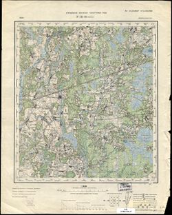
- Description:
- 1936
- Subject:
- Geographic Subject: Pogost, Topical Subject: Soviet Union, and Topical Subject: Maps
- Publisher:
- Управление военных топографов РККА
- Language:
- Russian
- Identifier:
- VAC9619-004083
- Genre:
- Topographic Maps and Military Maps
- Geographic Location:
- Coordinates: 53.667, 29, 54, 29.5
- Related URL:
- Download GeoTIFF: https://drive.google.com/file/d/1ubxMbYjRRzgdp4wP2Mhvx5c4jpGQ6YvL/view?usp=sharing and Catalog URL: https://iucat.iu.edu/catalog/5020129
- Abstract:
- Modern area represented: Pogost, Belarus
- Call Number:
- G7000 s100 .S7 sheet N-35-83
- Caption:
- Не подлежит оглашению
- City:
- Погост (Pogost)
- Copyright Holder:
- No Copyright - United States
- Country:
- СССР (USSR)
- State/Province:
- Белорусская ССР (Byelorussian Soviet Socialist Republic)
- Physical Description:
- Scale: 1:100,000
- Persistent URL:
- http://purl.dlib.indiana.edu/iudl/images/VAC9619/VAC9619-004083
- Provenance:
- Library of Congress G & M Division
-
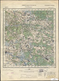
- Description:
- 1933
- Subject:
- Topical Subject: Soviet Union, Geographic Subject: Smilavichy, and Topical Subject: Maps
- Publisher:
- Управление военных топографов РККА
- Language:
- Russian
- Date Created:
- 1936
- Identifier:
- VAC9619-004081
- Genre:
- Military Maps and Topographic Maps
- Geographic Location:
- Coordinates: 53.667, 28, 54, 28.5
- Related URL:
- Download GeoTIFF: https://drive.google.com/file/d/1H8FweVO9LnHfFCQ6pbRGNdMLVVsrPnp4/view?usp=sharing and Catalog URL: https://iucat.iu.edu/catalog/5020129
- Abstract:
- Modern area represented: Smilavichy, Belarus
- Call Number:
- G7000 s100 .S7 sheet N-35-81
- Caption:
- Не подлежит оглашению
- City:
- Смиловичи (Smilavichy)
- Copyright Holder:
- No Copyright - United States
- Country:
- СССР (USSR)
- State/Province:
- Белорусская ССР (Byelorussian Soviet Socialist Republic)
- Physical Description:
- Scale: 1:100,000
- Persistent URL:
- http://purl.dlib.indiana.edu/iudl/images/VAC9619/VAC9619-004081
- Provenance:
- Library of Congress G & M Division
-
- Description:
- 1908
- Subject:
- Geographic Subject: Ivenets, Topical Subject: Maps, and Topical Subject: Soviet Union
- Publisher:
- Управление военных топографов РККА
- Language:
- Russian
- Date Created:
- 1933
- Identifier:
- VAC9619-004078
- Genre:
- Topographic Maps and Military Maps
- Geographic Location:
- Coordinates: 53.667, 26.5, 54, 27
- Related URL:
- Catalog URL: https://iucat.iu.edu/catalog/5020129 and Download GeoTIFF: https://drive.google.com/file/d/17IBW-4Qy8vDRjL3XAe46WFA6YEoc1hsn/view?usp=sharing
- Abstract:
- Modern area represented: Ivenets, Belarus
- Call Number:
- G7000 s100 .S7 sheet N-35-78
- Caption:
- Не подлежит оглашению
- City:
- Ивенец (Ivenets)
- Copyright Holder:
- No Copyright - United States
- Country:
- Польша (Poland) and СССР (USSR)
- State/Province:
- Белорусская ССР (Byelorussian Soviet Socialist Republic)
- Physical Description:
- Scale: 1:100,000
- Persistent URL:
- http://purl.dlib.indiana.edu/iudl/images/VAC9619/VAC9619-004078
- Provenance:
- DMA Topographic Center, Army Map Service Library, OMAHA
-
- Description:
- 1936
- Subject:
- Topical Subject: Maps, Geographic Subject: Krugloye, and Topical Subject: Soviet Union
- Publisher:
- Управление военных топографов РККА
- Language:
- Russian
- Identifier:
- VAC9619-004072
- Genre:
- Military Maps and Topographic Maps
- Geographic Location:
- Coordinates: 54, 29.5, 54.333, 30
- Related URL:
- Catalog URL: https://iucat.iu.edu/catalog/5020129 and Download GeoTIFF: https://drive.google.com/file/d/1DIBdyzRoAk5oP1Afn4bDHxeniBB05cvO/view?usp=sharing
- Abstract:
- Modern area represented: Krugloye, Belarus
- Call Number:
- G7000 s100 .S7 sheet N-35-72
- Caption:
- Не подлежит оглашению
- City:
- Круглое (Krugloye)
- Copyright Holder:
- No Copyright - United States
- Country:
- СССР (USSR)
- State/Province:
- Белорусская ССР (Byelorussian Soviet Socialist Republic)
- Physical Description:
- Scale: 1:100,000
- Persistent URL:
- http://purl.dlib.indiana.edu/iudl/images/VAC9619/VAC9619-004072
- Provenance:
- DMA Topographic Center, Army Map Service Library, OMAHA
-

- Description:
- 1936
- Subject:
- Geographic Subject: Golochin, Topical Subject: Maps, and Topical Subject: Soviet Union
- Publisher:
- Управление военных топографов РККА
- Language:
- Russian
- Identifier:
- VAC9619-004061
- Genre:
- Topographic Maps and Military Maps
- Geographic Location:
- Coordinates: 54.333, 29.5, 54.667, 30
- Related URL:
- Download GeoTIFF: https://drive.google.com/file/d/1b_Z20-vaDKj5kD5kF0COX94rPbY8G7hJ/view?usp=sharing and Catalog URL: https://iucat.iu.edu/catalog/5020129
- Abstract:
- Modern area represented: Golochin, Vitebsk oblast, Belarus
- Call Number:
- G7000 s100 .S7 sheet N-35-60
- Caption:
- Не подлежит оглашению
- City:
- Толочин (Golochin)
- Copyright Holder:
- No Copyright - United States
- Country:
- СССР (USSR)
- State/Province:
- Белорусская ССР (Byelorussian Soviet Socialist Republic)
- Physical Description:
- Scale: 1:100,000
- Persistent URL:
- http://purl.dlib.indiana.edu/iudl/images/VAC9619/VAC9619-004061
- Provenance:
- DMA Topographic Center, Army Map Service Library, OMAHA
-
- Description:
- 1904
- Subject:
- Topical Subject: Maps, Topical Subject: Soviet Union, and Geographic Subject: Narach
- Publisher:
- Управление военных топографов РККА
- Language:
- Russian
- Date Created:
- 1932
- Identifier:
- VAC9619-004044
- Genre:
- Topographic Maps and Military Maps
- Geographic Location:
- Coordinates: 54.667, 26.5, 55, 27
- Related URL:
- Download GeoTIFF: https://drive.google.com/file/d/1ySkPy2U00iCU1rCOyRHLB2101kzdO-CK/view?usp=sharing and Catalog URL: https://iucat.iu.edu/catalog/5020129
- Abstract:
- Modern area represented: Narach, Belarus
- Call Number:
- G7000 s100 .S7 sheet N-35-42
- City:
- Кобыльник (Kobylnik)
- Copyright Holder:
- No Copyright - United States
- Country:
- Польша (Poland)
- Physical Description:
- Scale: 1:100,000
- Persistent URL:
- http://purl.dlib.indiana.edu/iudl/images/VAC9619/VAC9619-004044
- Provenance:
- DMA Topographic Center, Army Map Service Library, OMAHA, Library of Congress Geography & Map Division
-
- Description:
- 1885
- Subject:
- Topical Subject: Soviet Union, Geographic Subject: Raciąż Polka, and Topical Subject: Maps
- Publisher:
- Управление военных топографов РККА
- Language:
- Russian
- Date Created:
- 1888
- Identifier:
- VAC9619-003977
- Genre:
- Topographic Maps and Military Maps
- Geographic Location:
- Coordinates: 52.667, 20, 53, 20.5
- Related URL:
- Download GeoTIFF: https://drive.google.com/file/d/1C3iqxLwwbxcIaKffMdzNGy30BcFpr1JA/view?usp=sharing and Catalog URL: https://iucat.iu.edu/catalog/5020129
- Abstract:
- Modern area represented: Raciąż Polka, Masovian Voivodeship, Poland
- Call Number:
- G7000 s100 .S7 sheet N-34-113
- City:
- Рационж (Raciąż)
- Copyright Holder:
- No Copyright - United States
- Country:
- Польша (Poland)
- Physical Description:
- Scale: 1:100,000
- Persistent URL:
- http://purl.dlib.indiana.edu/iudl/images/VAC9619/VAC9619-003977
- Provenance:
- DMA Topographic Center, Army Map Service Library, Auswärtiges Amt. Geographischer Dienst
-
- Description:
- 1910
- Subject:
- Topical Subject: Maps, Geographic Subject: Polessk, and Topical Subject: Soviet Union
- Publisher:
- Управление военных топографов РККА
- Language:
- Russian
- Date Created:
- 1928
- Identifier:
- VAC9619-003913
- Genre:
- Military Maps and Topographic Maps
- Geographic Location:
- Coordinates: 54.667, 21, 55, 21.5
- Related URL:
- Catalog URL: https://iucat.iu.edu/catalog/5020129 and Download GeoTIFF: https://drive.google.com/file/d/1IRnoyrDyqjZkwHrK_XVtXDcMtf29hwAT/view?usp=sharing
- Abstract:
- Modern area represented: Polessk, Kaliningrad oblast, Russia
- Call Number:
- G7000 s100 .S7 sheet N-34-43
- Caption:
- Не подлежит оглашению
- City:
- Лабиау (Labiau)
- Copyright Holder:
- No Copyright - United States
- State/Province:
- Восточная Пруссия (East Prussia) and Кенигсбергская провинция (Königsberg province)
- Physical Description:
- Scale: 1:100,000
- Persistent URL:
- http://purl.dlib.indiana.edu/iudl/images/VAC9619/VAC9619-003913
- Provenance:
- Army Map Service Library, Library of Congress G & M Division, Geographic Names Branch
-

- Description:
- 1908
- Subject:
- Topical Subject: Maps, Geographic Subject: Yantarny, and Topical Subject: Soviet Union
- Publisher:
- Управление военных топографов РККА
- Language:
- Russian
- Date Created:
- 1928
- Identifier:
- VAC9619-003911
- Genre:
- Military Maps and Topographic Maps
- Geographic Location:
- Coordinates: 54.667, 19.5, 55, 20
- Related URL:
- Download GeoTIFF: https://drive.google.com/file/d/1dCJrZ1SuQd812fK7d-NEq2x14iF7ZB72/view?usp=sharing and Catalog URL: https://iucat.iu.edu/catalog/5020129
- Abstract:
- Modern area represented: Yantarny, Kaliningrad oblast, Russia
- Call Number:
- G7000 s100 .S7 sheet N-34-40
- Caption:
- Не подлежит оглашению
- City:
- Кракстепеллен (Kraxtepellen)
- Copyright Holder:
- No Copyright - United States
- State/Province:
- Восточная Пруссия (East Prussia) and Кенигсбергская провинция (Königsberg province)
- Physical Description:
- Scale: 1:100,000
- Persistent URL:
- http://purl.dlib.indiana.edu/iudl/images/VAC9619/VAC9619-003911
- Provenance:
- CIA Map Branch -- Received, CIA Map Library
-
- Description:
- 1892
- Subject:
- Topical Subject: Maps, Topical Subject: Soviet Union, and Geographic Subject: Krakės
- Publisher:
- Управление военных топографов РККА
- Language:
- Russian
- Date Created:
- 1898
- Identifier:
- VAC9619-003904
- Genre:
- Topographic Maps and Military Maps
- Geographic Location:
- Coordinates: 55.333, 23.5, 55.667, 24
- Related URL:
- Catalog URL: https://iucat.iu.edu/catalog/5020129 and Download GeoTIFF: https://drive.google.com/file/d/1eP8FUfuMjxQiuhhZ5NVjCmhrcArwapQv/view?usp=sharing
- Abstract:
- Modern area represented: Krakės, Lithuania
- Call Number:
- G7000 s100 .S7 sheet N-34-24
- City:
- Кроки (Kroki)
- Copyright Holder:
- No Copyright - United States
- Country:
- Литва (Lithuania)
- Physical Description:
- Scale: 1:100,000
- Persistent URL:
- http://purl.dlib.indiana.edu/iudl/images/VAC9619/VAC9619-003904
- Provenance:
- DMA Topographic Center, Army Map Service Library, Auswärtiges Amt. Geographischer Dienst
-
- Description:
- 1892
- Subject:
- Geographic Subject: Raseiniai, Topical Subject: Soviet Union, and Topical Subject: Maps
- Publisher:
- Управление военных топографов РККА
- Language:
- Russian
- Date Created:
- 1894
- Identifier:
- VAC9619-003903
- Genre:
- Topographic Maps and Military Maps
- Geographic Location:
- Coordinates: 55.333, 23, 55.667, 23.5
- Related URL:
- Catalog URL: https://iucat.iu.edu/catalog/5020129 and Download GeoTIFF: https://drive.google.com/file/d/1tmXQFHBkCfSkDM6lzkHUehMJPLaPBPTe/view?usp=sharing
- Abstract:
- Modern area represented: Raseiniai, Kaunas, Lithuania
- Call Number:
- G7000 s100 .S7 sheet N-34-23
- City:
- Россиены (Raseiniai)
- Copyright Holder:
- No Copyright - United States
- Country:
- Литва (Lithuania)
- Physical Description:
- Scale: 1:100,000
- Persistent URL:
- http://purl.dlib.indiana.edu/iudl/images/VAC9619/VAC9619-003903
- Provenance:
- DMA Topographic Center, Army Map Service Library
-
- Description:
- 1894
- Subject:
- Topical Subject: Maps, Topical Subject: Soviet Union, and Geographic Subject: Šilutė
- Publisher:
- Управление военных топографов РККА
- Language:
- Russian
- Date Created:
- 1912
- Identifier:
- VAC9619-003899
- Genre:
- Military Maps and Topographic Maps
- Geographic Location:
- Coordinates: 55.333, 21, 55.667, 21.5
- Related URL:
- Download GeoTIFF: https://drive.google.com/file/d/1IHHnxhC0ySuJTtWCJ48iYBtPYIwl60II/view?usp=sharing and Catalog URL: https://iucat.iu.edu/catalog/5020129
- Abstract:
- Modern area represented: Šilutė, Klaipėda County, Lithuania
- Call Number:
- G7000 s100 .S7 sheet N-34-19
- City:
- Шилутэ (Šilutė)
- Copyright Holder:
- No Copyright - United States
- Country:
- Литва (Lithuania)
- Physical Description:
- Scale: 1:100,000
- Persistent URL:
- http://purl.dlib.indiana.edu/iudl/images/VAC9619/VAC9619-003899
- Provenance:
- Army Map Service Library, Library of Congress G & M Division, Geographic Names Branch
-
- Description:
- 1894
- Subject:
- Topical Subject: Maps, Geographic Subject: Klaipėda, and Topical Subject: Soviet Union
- Publisher:
- Управление военных топографов РККА
- Language:
- Russian
- Date Created:
- 1910
- Identifier:
- VAC9619-003895
- Genre:
- Military Maps and Topographic Maps
- Geographic Location:
- Coordinates: 55.667, 21, 56, 21.5
- Related URL:
- Download GeoTIFF: https://drive.google.com/file/d/1Ww8-LLBsEzHcY-lFDTijchVNj8HHcVlj/view?usp=sharing and Catalog URL: https://iucat.iu.edu/catalog/5020129
- Abstract:
- Modern area represented: Klaipėda, Klaipėda county, Lithuania
- Call Number:
- G7000 s100 .S7 sheet N-34-7
- City:
- Клайпеда (Klaipėda)
- Copyright Holder:
- No Copyright - United States
- Country:
- Литва (Lithuania)
- Physical Description:
- Scale: 1:100,000
- Persistent URL:
- http://purl.dlib.indiana.edu/iudl/images/VAC9619/VAC9619-003895
- Provenance:
- DMA Topographic Center, Army Map Service Library
-
- Description:
- 1936
- Subject:
- Geographic Subject: Koreyskaya, Topical Subject: Soviet Union, and Topical Subject: Maps
- Publisher:
- Управление военных топографов РККА
- Language:
- Russian
- Identifier:
- VAC9619-003559
- Genre:
- Topographic Maps and Military Maps
- Geographic Location:
- Coordinates: 48, 139, 48.333, 139.5
- Related URL:
- Catalog URL: https://iucat.iu.edu/catalog/5020129 and Download GeoTIFF: https://drive.google.com/file/d/1J1eSWgkMdDjicXLuztq43Vs-UL13TMrM/view?usp=sharing
- Abstract:
- Modern area represented: Koreyskaya, Khabarovsk oblast, Russia
- Call Number:
- G7000 s100 .S7 sheet M-54-135
- Caption:
- Не подлежит оглашению
- City:
- Корейская Заимка (Koreyskaya Zaimka)
- Copyright Holder:
- No Copyright - United States
- Country:
- СССР (USSR)
- State/Province:
- Дальневосточный край (Far Eastern kray) and РСФСР (RSFSR)
- Physical Description:
- Scale: 1:100,000
- Persistent URL:
- http://purl.dlib.indiana.edu/iudl/images/VAC9619/VAC9619-003559
- Provenance:
- Army Map Service Library, Library of Congress G & M Division, Atlasblatt
-

- Description:
- 1936
- Subject:
- Geographic Subject: Innokentyevskiy, Topical Subject: Maps, and Topical Subject: Soviet Union
- Publisher:
- Управление военных топографов РККА
- Language:
- Russian
- Identifier:
- VAC9619-003558
- Genre:
- Topographic Maps and Military Maps
- Geographic Location:
- Coordinates: 48.333, 140, 48.667, 140.5
- Related URL:
- Download GeoTIFF: https://drive.google.com/file/d/1jImq4VNtOBm6f1osXZuu2L9XIv1bwqy8/view?usp=sharing and Catalog URL: https://iucat.iu.edu/catalog/5020129
- Abstract:
- Modern area represented: Innokentyevskiy, Khabarovsk kray, Russia
- Call Number:
- G7000 s100 .S7 sheet M-54-125
- Caption:
- Не подлежит оглашению
- City:
- Иннокентьевская (Innokentyevskaya)
- Copyright Holder:
- No Copyright - United States
- Country:
- СССР (USSR)
- State/Province:
- Дальневосточный край (Far Eastern kray) and РСФСР (RSFSR)
- Physical Description:
- Scale: 1:100,000
- Persistent URL:
- http://purl.dlib.indiana.edu/iudl/images/VAC9619/VAC9619-003558
- Provenance:
- Army Map Service Library, Library of Congress G & M Division, Atlasblatt
-

- Description:
- 1936
- Subject:
- Topical Subject: Soviet Union, Topical Subject: Maps, and Geographic Subject: Stoybishche Ulma
- Publisher:
- Управление военных топографов РККА
- Language:
- Russian
- Identifier:
- VAC9619-003557
- Genre:
- Military Maps and Topographic Maps
- Geographic Location:
- Coordinates: 48.333, 139.5, 48.667, 140
- Related URL:
- Download GeoTIFF: https://drive.google.com/file/d/1llDg_ecXuS_LEtRBjspfUB9_kOybLe54/view?usp=sharing and Catalog URL: https://iucat.iu.edu/catalog/5020129
- Abstract:
- Modern area represented: Stoybishche Ulma, Khabarovsk oblast, Russia
- Call Number:
- G7000 s100 .S7 sheet M-54-124
- Caption:
- Не подлежит оглашению
- City:
- Стойбище Ульма (Stoybishche Ulma)
- Copyright Holder:
- No Copyright - United States
- Country:
- СССР (USSR)
- State/Province:
- РСФСР (RSFSR) and Дальневосточный край (Far Eastern kray)
- Physical Description:
- Scale: 1:100,000
- Persistent URL:
- http://purl.dlib.indiana.edu/iudl/images/VAC9619/VAC9619-003557
- Provenance:
- Army Map Service Library, Library of Congress G & M Division, Atlasblatt
-

- Description:
- 1936
- Subject:
- Geographic Subject: Koppi river, Topical Subject: Soviet Union, and Topical Subject: Maps
- Publisher:
- Управление военных топографов РККА
- Language:
- Russian
- Identifier:
- VAC9619-003556
- Genre:
- Military Maps and Topographic Maps
- Geographic Location:
- Coordinates: 48.333, 139, 48.667, 139.5
- Related URL:
- Download GeoTIFF: https://drive.google.com/file/d/1IKbhd2Bnfi5dgkkYmTcnEvKG0lu0oj-7/view?usp=sharing and Catalog URL: https://iucat.iu.edu/catalog/5020129
- Abstract:
- Modern area represented: Khabarovsk oblast, Russia
- Call Number:
- G7000 s100 .S7 sheet M-54-123
- Caption:
- Не подлежит оглашению
- City:
- Р.Коппи (Koppi river)
- Copyright Holder:
- No Copyright - United States
- Country:
- СССР (USSR)
- State/Province:
- РСФСР (RSFSR) and Дальневосточный край (Far Eastern kray)
- Physical Description:
- Scale: 1:100,000
- Persistent URL:
- http://purl.dlib.indiana.edu/iudl/images/VAC9619/VAC9619-003556
- Provenance:
- Army Map Service Library, Library of Congress G & M Division, Atlasblatt
-

- Description:
- 1935
- Subject:
- Topical Subject: Soviet Union, Geographic Subject: Yermakovskiy, and Topical Subject: Maps
- Publisher:
- Управление военных топографов РККА
- Language:
- Russian
- Identifier:
- VAC9619-003552
- Genre:
- Topographic Maps and Military Maps
- Geographic Location:
- Coordinates: 48.333, 131, 48.667, 131.5
- Related URL:
- Catalog URL: https://iucat.iu.edu/catalog/5020129 and Download GeoTIFF: https://drive.google.com/file/d/1OuXQtbTLHq_xw0vo85Sv_aXpj7gqXevO/view?usp=sharing
- Abstract:
- Modern area represented: Yermakovskiy, Russia
- Call Number:
- G7000 s100 .S7 sheet M-52-131
- Caption:
- Не подлежит оглашению
- City:
- Ермаковский (Yermakovskiy)
- Copyright Holder:
- No Copyright - United States
- Country:
- СССР (USSR)
- State/Province:
- РСФСР (RSFSR) and Дальневосточный край (Far Eastern kray)
- Physical Description:
- Scale: 1:100,000
- Persistent URL:
- http://purl.dlib.indiana.edu/iudl/images/VAC9619/VAC9619-003552
- Provenance:
- Library of Congress G & M Division, Army Map Service Library
-
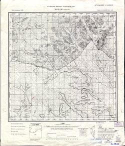
- Description:
- 1913
- Subject:
- Geographic Subject: Baldzhikan, Topical Subject: Maps, and Topical Subject: Soviet Union
- Publisher:
- Управление военных топографов РККА
- Language:
- Russian
- Date Created:
- 1936
- Identifier:
- VAC9619-003551
- Genre:
- Topographic Maps and Military Maps
- Geographic Location:
- Coordinates: 49, 110, 49.333, 110.5
- Related URL:
- Download GeoTIFF: https://drive.google.com/file/d/1EDdpb1Qpq4XTzjSQ3wYTtMmQ_tYdDFSv/view?usp=sharing and Catalog URL: https://iucat.iu.edu/catalog/5020129
- Abstract:
- Modern area represented: Baldzhikan, Transbaikal territory, Russia
- Call Number:
- G7000 s100 .S7 sheet M-49-101
- Caption:
- Не подлежит оглашению
- City:
- Бальджикан (Baldzhikan)
- Copyright Holder:
- No Copyright - United States
- Country:
- СССР (USSR)
- State/Province:
- РСФСР (RSFSR) and Читинская область (Chita oblast)
- Physical Description:
- Scale: 1:100,000
- Persistent URL:
- http://purl.dlib.indiana.edu/iudl/images/VAC9619/VAC9619-003551
- Provenance:
- Library of Congress G & M Division, University of Kansas Map Library
-
- Description:
- 1926
- Subject:
- Geographic Subject: Novoye, Topical Subject: Soviet Union, and Topical Subject: Maps
- Publisher:
- Управление военных топографов РККА
- Language:
- Russian
- Identifier:
- VAC9619-003538
- Genre:
- Topographic Maps and Military Maps
- Geographic Location:
- Coordinates: 57.167, 30, 57.333, 30.25
- Related URL:
- Download GeoTIFF: https://drive.google.com/file/d/1_ZgjN1E6psP0P6hvxP2ZANr3zbym9FI2/view?usp=sharing and Catalog URL: http://iucat.iu.edu/catalog/5020131
- Abstract:
- Modern area represented: Новое (Novoye), Pskovskaya oblast, Russia
- Call Number:
- GM G7000 s50 .S68 sheet O-36-97-A
- Caption:
- Не подлежит оглашению
- City:
- Пог. Новое (Novoye)
- Copyright Holder:
- No Copyright - United States
- Country:
- СССР (USSR)
- State/Province:
- Ленинградская область (Leningrad oblast), РСФСР (RSFSR), and Калининская область (Kalinin oblast)
- Physical Description:
- Scale: 1:50,000
- Persistent URL:
- http://purl.dlib.indiana.edu/iudl/images/VAC9619/VAC9619-003538
- Provenance:
- Army Map Service Library, OMAHA, Library of Congress Geography & Map Division
-

- Subject:
- Topical Subject: Soviet Union, Geographic Subject: Zakharovo, and Topical Subject: Maps
- Publisher:
- Управление военных топографов РККА
- Language:
- Russian
- Identifier:
- VAC9619-003479
- Genre:
- Military Maps and Topographic Maps
- Geographic Location:
- Coordinates: 56.167, 30, 56.333, 30.25
- Related URL:
- Download GeoTIFF: https://drive.google.com/file/d/18qVdwAsXlKVJqWQ87u7VFZ3iwvTgaxI9/view?usp=sharing and Catalog URL: http://iucat.iu.edu/catalog/5020131
- Abstract:
- Modern area represented: Захарово (Zakharovo), Tverskaya oblast, Russia
- Call Number:
- G7000 s50 .S68 sheet O-36-133-A
- Caption:
- Не подлежит оглашению
- City:
- Захарова (Zakharova)
- Copyright Holder:
- No Copyright - United States
- Country:
- СССР (USSR)
- State/Province:
- Калининская область (Kalinin oblast) and РСФСР (RSFSR)
- Physical Description:
- Scale: 1:50,000
- Persistent URL:
- http://purl.dlib.indiana.edu/iudl/images/VAC9619/VAC9619-003479
- Provenance:
- M. I. Map Library
-
- Description:
- 1910
- Subject:
- Topical Subject: Maps, Geographic Subject: Khrystynivka, and Topical Subject: Soviet Union
- Publisher:
- Управление военных топографов РККА
- Language:
- Russian
- Date Created:
- 1932
- Identifier:
- VAC9619-003244
- Genre:
- Topographic Maps and Military Maps
- Geographic Location:
- Coordinates: 48.667, 29.5, 49, 30
- Related URL:
- Catalog URL: https://iucat.iu.edu/catalog/5020129 and Download GeoTIFF: https://drive.google.com/file/d/18XiPWIGh6qpclep03S-jZjfpBuTFbG9-/view?usp=sharing
- Abstract:
- Modern area represented: Khrystynivka, Cherkasy oblast, Ukraine
- Call Number:
- G7000 s100 .S7 sheet M-35-120
- Caption:
- Не подлежит оглашению
- City:
- Христинивка (Khrystynivka)
- Copyright Holder:
- No Copyright - United States
- Country:
- СССР (USSR)
- State/Province:
- Украинская ССР (Ukrainian Soviet Socialist Republic), Винницкая область (Vinnytsia oblast), and Киевская область (Kyiv oblast)
- Physical Description:
- Scale: 1:100,000
- Persistent URL:
- http://purl.dlib.indiana.edu/iudl/images/VAC9619/VAC9619-003244
- Provenance:
- DMA Topographic Center, Army Map Service Library, Library of Congress Geography & Map Division, Atlasblatt
-
- Description:
- 1908
- Subject:
- Topical Subject: Soviet Union, Topical Subject: Maps, and Geographic Subject: Pohrebyshche
- Publisher:
- Управление военных топографов РККА
- Language:
- Russian
- Date Created:
- 1932
- Identifier:
- VAC9619-003238
- Genre:
- Topographic Maps and Military Maps
- Geographic Location:
- Coordinates: 49.333, 29, 49.667, 29.5
- Related URL:
- Download GeoTIFF: https://drive.google.com/file/d/1GHx_mmI5hvqTaOEWVpNlw-qSYlmo67I7/view?usp=sharing and Catalog URL: https://iucat.iu.edu/catalog/5020129
- Abstract:
- Modern area represented: Pohrebyshche, Vinnytsia oblast, Ukraine
- Call Number:
- G7000 s100 .S7 sheet M-35-95
- Caption:
- Не подлежит оглашению
- City:
- Погребище (Pohrebyshche)
- Copyright Holder:
- No Copyright - United States
- Country:
- СССР (USSR)
- State/Province:
- Житомирская область (Zhytomyr oblast), Украинская ССР (Ukrainian Soviet Socialist Republic), and Винницкая область (Vinnytsia oblast)
- Physical Description:
- Scale: 1:100,000
- Persistent URL:
- http://purl.dlib.indiana.edu/iudl/images/VAC9619/VAC9619-003238
- Provenance:
- DMA Topographic Center, Army Map Service Library, OMAHA, Atlasblatt
-
- Description:
- 1908
- Subject:
- Topical Subject: Soviet Union, Topical Subject: Maps, and Geographic Subject: Tetiiv
- Publisher:
- Управление военных топографов РККА
- Language:
- Russian
- Date Created:
- 1932
- Identifier:
- VAC9619-003239
- Genre:
- Topographic Maps and Military Maps
- Geographic Location:
- Coordinates: 49.333, 29.5, 49.667, 30
- Related URL:
- Catalog URL: https://iucat.iu.edu/catalog/5020129 and Download GeoTIFF: https://drive.google.com/file/d/15rD4SElGLCQ5CJTIbdpXogtRv0MhdkDX/view?usp=sharing
- Abstract:
- Modern area represented: Tetiiv, Kiev oblast, Ukraine
- Call Number:
- G7000 s100 .S7 sheet M-35-96
- Caption:
- Не подлежит оглашению
- City:
- Тетиев (Tetiiv)
- Copyright Holder:
- No Copyright - United States
- Country:
- СССР (USSR)
- State/Province:
- Киевская область (Kyiv oblast) and Украинская ССР (Ukrainian Soviet Socialist Republic)
- Physical Description:
- Scale: 1:100,000
- Persistent URL:
- http://purl.dlib.indiana.edu/iudl/images/VAC9619/VAC9619-003239
- Provenance:
- DMA Topographic Center, Army Map Service Library, OMAHA
-
- Description:
- 1932
- Subject:
- Topical Subject: Soviet Union, Topical Subject: Maps, and Geographic Subject: Ivaniv
- Publisher:
- Управление военных топографов РККА
- Language:
- Russian
- Identifier:
- VAC9619-003236
- Genre:
- Topographic Maps and Military Maps
- Geographic Location:
- Coordinates: 49.333, 28, 49.667, 28.5
- Related URL:
- Catalog URL: https://iucat.iu.edu/catalog/5020129 and Download GeoTIFF: https://drive.google.com/file/d/1kiS3y9qU5c_JTKLVp46XkZyAypuXGudc/view?usp=sharing
- Abstract:
- Modern area represented: Ivaniv, Vinnytsia oblast, Ukraine
- Call Number:
- G7000 s100 .S7 sheet M-35-93
- Caption:
- Не подлежит оглашению
- City:
- Янов (Janov)
- Copyright Holder:
- No Copyright - United States
- Country:
- СССР (USSR)
- State/Province:
- Винницкая область (Vinnytsia oblast) and Украинская ССР (Ukrainian Soviet Socialist Republic)
- Physical Description:
- Scale: 1:100,000
- Persistent URL:
- http://purl.dlib.indiana.edu/iudl/images/VAC9619/VAC9619-003236
- Provenance:
- DMA Topographic Center, Army Map Service Library, Geographic Names Branch
-
- Description:
- 1908
- Subject:
- Topical Subject: Maps, Topical Subject: Soviet Union, and Geographic Subject: Skvyra
- Publisher:
- Управление военных топографов РККА
- Language:
- Russian
- Date Created:
- 1932
- Identifier:
- VAC9619-003226
- Genre:
- Military Maps and Topographic Maps
- Geographic Location:
- Coordinates: 49.667, 29.5, 50, 30
- Related URL:
- Catalog URL: https://iucat.iu.edu/catalog/5020129 and Download GeoTIFF: https://drive.google.com/file/d/1X6k4JhpLWztEqRQl3FXa53tln54PHEVO/view?usp=sharing
- Abstract:
- Modern area represented: Skvyra, Kiev oblast, Ukraine
- Call Number:
- G7000 s100 .S7 sheet M-35-84
- Caption:
- Не подлежит оглашению
- City:
- Сквира (Skvyra)
- Copyright Holder:
- No Copyright - United States
- Country:
- СССР (USSR)
- State/Province:
- Киевская область (Kyiv oblast) and Украинская ССР (Ukrainian Soviet Socialist Republic)
- Physical Description:
- Scale: 1:100,000
- Persistent URL:
- http://purl.dlib.indiana.edu/iudl/images/VAC9619/VAC9619-003226
- Provenance:
- DMA Topographic Center, Army Map Service Library, OMAHA
-
- Description:
- 1908
- Subject:
- Topical Subject: Soviet Union, Topical Subject: Maps, and Geographic Subject: Chudniv
- Publisher:
- Управление военных топографов РККА
- Language:
- Russian
- Date Created:
- 1932
- Identifier:
- VAC9619-003223
- Genre:
- Topographic Maps and Military Maps
- Geographic Location:
- Coordinates: 50, 28, 50.333, 28.5
- Related URL:
- Catalog URL: https://iucat.iu.edu/catalog/5020129 and Download GeoTIFF: https://drive.google.com/file/d/1SkZk5hQRmHL7hW9Yn3FqmEo2eW42Cg9c/view?usp=sharing
- Abstract:
- Modern area represented: Chudniv, Zhytomyr oblast, Ukraine
- Call Number:
- G7000 s100 .S7 sheet M-35-69
- Caption:
- Не подлежит оглашению
- City:
- Чуднов (Chudniv)
- Copyright Holder:
- No Copyright - United States
- Country:
- СССР (USSR)
- State/Province:
- Винницкая область (Vinnytsia oblast), Украинская ССР (Ukrainian Soviet Socialist Republic), and Киевская область (Kyiv oblast)
- Physical Description:
- Scale: 1:100,000
- Persistent URL:
- http://purl.dlib.indiana.edu/iudl/images/VAC9619/VAC9619-003223
- Provenance:
- DMA Topographic Center, Army Map Service Library, OMAHA, Library of Congress Geography & Map Division
-
- Description:
- 1913
- Subject:
- Topical Subject: Maps, Geographic Subject: Korosten, and Topical Subject: Soviet Union
- Publisher:
- Управление военных топографов РККА
- Language:
- Russian
- Date Created:
- 1933
- Identifier:
- VAC9619-003119
- Genre:
- Military Maps and Topographic Maps
- Geographic Location:
- Coordinates: 50.667, 28.5, 51, 29
- Related URL:
- Catalog URL: https://iucat.iu.edu/catalog/5020129 and Download GeoTIFF: https://drive.google.com/file/d/1r4KaIwlzKRcnmPHpmBYXDKSMN0LMEF56/view?usp=sharing
- Abstract:
- Modern area represented: Korosten, Zhytomyr oblast, Ukraine
- Call Number:
- G7000 s100 .S7 sheet M-35-46
- Caption:
- Не подлежит оглашению
- City:
- Коростень (Korosten)
- Copyright Holder:
- No Copyright - United States
- Country:
- СССР (USSR)
- State/Province:
- Украинская ССР (Ukrainian Soviet Socialist Republic) and Киевская область (Kyiv oblast)
- Physical Description:
- Scale: 1:100,000
- Persistent URL:
- http://purl.dlib.indiana.edu/iudl/images/VAC9619/VAC9619-003119
- Provenance:
- DMA Topographic Center, Army Map Service Library, OMAHA
-
- Description:
- 1913
- Subject:
- Geographic Subject: Ivankiv, Topical Subject: Soviet Union, and Topical Subject: Maps
- Publisher:
- Управление военных топографов РККА
- Language:
- Russian
- Date Created:
- 1933
- Identifier:
- VAC9619-003120
- Genre:
- Topographic Maps and Military Maps
- Geographic Location:
- Coordinates: 50.667, 29.5, 51, 30
- Related URL:
- Download GeoTIFF: https://drive.google.com/file/d/1Ra_HooqAngw0iRatiTrefjd7SIFeN4au/view?usp=sharing and Catalog URL: https://iucat.iu.edu/catalog/5020129
- Abstract:
- Modern area represented: Ivankiv, Kiev oblast, Ukraine
- Call Number:
- G7000 s100 .S7 sheet M-35-48
- Caption:
- Не подлежит оглашению
- City:
- Иванков (Ivankiv)
- Copyright Holder:
- No Copyright - United States
- Country:
- СССР (USSR)
- State/Province:
- Киевская область (Kyiv oblast) and Украинская ССР (Ukrainian Soviet Socialist Republic)
- Physical Description:
- Scale: 1:100,000
- Persistent URL:
- http://purl.dlib.indiana.edu/iudl/images/VAC9619/VAC9619-003120
- Provenance:
- DMA Topographic Center, Army Map Service Library, OMAHA
-
- Description:
- 1913
- Subject:
- Topical Subject: Soviet Union, Topical Subject: Maps, and Geographic Subject: Makariv
- Publisher:
- Управление военных топографов РККА
- Language:
- Russian
- Date Created:
- 1933
- Identifier:
- VAC9619-003123
- Genre:
- Topographic Maps and Military Maps
- Geographic Location:
- Coordinates: 50.333, 29.5, 50.667, 30
- Related URL:
- Catalog URL: https://iucat.iu.edu/catalog/5020129 and Download GeoTIFF: https://drive.google.com/file/d/13LZmOOndyLlk6oJu1Lq5Rp9sPNueEMsP/view?usp=sharing
- Abstract:
- Modern area represented: Makariv, Kiev oblast, Ukraine
- Call Number:
- G7000 s100 .S7 sheet M-35-60
- Caption:
- Не подлежит оглашению
- City:
- Макаров (Makariv)
- Copyright Holder:
- No Copyright - United States
- Country:
- СССР (USSR)
- State/Province:
- Киевская область (Kyiv oblast) and Украинская ССР (Ukrainian Soviet Socialist Republic)
- Physical Description:
- Scale: 1:100,000
- Persistent URL:
- http://purl.dlib.indiana.edu/iudl/images/VAC9619/VAC9619-003123
- Provenance:
- DMA Topographic Center, Army Map Service Library, OMAHA, Library of Congress Geography & Map Division
-

- Description:
- 1937
- Subject:
- Topical Subject: Soviet Union, Geographic Subject: Sobinka, and Topical Subject: Maps
- Publisher:
- Управление военных топографов РККА
- Language:
- Russian
- Identifier:
- VAC9619-003152
- Genre:
- Topographic Maps and Military Maps
- Geographic Location:
- Coordinates: 55.667, 40, 56, 40.5
- Related URL:
- Download GeoTIFF: https://drive.google.com/file/d/18XFGeUqIyusPtI-9E0rlao6FNjdJ8w_V/view?usp=sharing and Catalog URL: https://iucat.iu.edu/catalog/5020129
- Abstract:
- Modern area represented: Собинка (Sobinka), Vladimirskaya oblast, Russia
- Call Number:
- G7000 s100 .S7 sheet N-37-9
- Caption:
- Не подлежит оглашению
- City:
- Собинка (Sobinka)
- Copyright Holder:
- No Copyright - United States
- Country:
- СССР (USSR)
- State/Province:
- Московская область (Moscow oblast), РСФСР (RSFSR), and Ивановская область (Ivanovo oblast)
- Physical Description:
- Scale: 1:100,000
- Persistent URL:
- http://purl.dlib.indiana.edu/iudl/images/VAC9619/VAC9619-003152
- Provenance:
- DMA Topographic Center, Army Map Service Library, University of Kansas Map Library
-
- Description:
- 1928
- Subject:
- Geographic Subject: Yamok, Topical Subject: Soviet Union, and Topical Subject: Maps
- Publisher:
- Управление военных топографов РККА
- Language:
- Russian
- Identifier:
- VAC9619-002908
- Genre:
- Topographic Maps and Military Maps
- Geographic Location:
- Coordinates: 58.167, 31, 58.333, 31.25
- Related URL:
- Download GeoTIFF: https://drive.google.com/file/d/13xdoAPyugrMoIH4z4ALuwGzAXPgLvpD5/view?usp=sharing and Catalog URL: http://iucat.iu.edu/catalog/5020131
- Abstract:
- Modern area represented: Ямок (Yamok), Novgorodskaya oblast, Russia
- Call Number:
- GM G7000 s50 .S68 sheet O-36-63-A
- Caption:
- Captured map and Не подлежит оглашению
- City:
- Ямок (Yamok)
- Copyright Holder:
- No Copyright - United States
- Country:
- СССР (USSR)
- State/Province:
- Ленинградская область (Leningrad oblast) and РСФСР (RSFSR)
- Physical Description:
- Scale: 1:50,000
- Persistent URL:
- http://purl.dlib.indiana.edu/iudl/images/VAC9619/VAC9619-002908
- Provenance:
- DMA Topographic Center, Army Map Service Library, OMAHA, Library of Congress Geography & Map Division
-
- Description:
- 1932
- Subject:
- Geographic Subject: Dubovitsy, Topical Subject: Maps, and Topical Subject: Soviet Union
- Publisher:
- Управление военных топографов РККА
- Language:
- Russian
- Identifier:
- VAC9619-002910
- Genre:
- Military Maps and Topographic Maps
- Geographic Location:
- Coordinates: 58, 31.25, 58.167, 31.5
- Related URL:
- Download GeoTIFF: https://drive.google.com/file/d/11lrrwu-O6aKaQFXf1WyZZe34R5FE4zhI/view?usp=sharing and Catalog URL: http://iucat.iu.edu/catalog/5020131
- Abstract:
- Modern area represented: Дубовицы (Dubovitsy), Novgorodskaya oblast, Russia
- Call Number:
- GM G7000 s50 .S68 sheet O-36-63-D
- Caption:
- Не подлежит оглашению and Captured map
- City:
- Дубовицы (Dubovitsy)
- Copyright Holder:
- No Copyright - United States
- Country:
- СССР (USSR)
- State/Province:
- РСФСР (RSFSR) and Ленинградская область (Leningrad oblast)
- Physical Description:
- Scale: 1:50,000
- Persistent URL:
- http://purl.dlib.indiana.edu/iudl/images/VAC9619/VAC9619-002910
- Provenance:
- DMA Topographic Center, Army Map Service Library, OMAHA, Library of Congress Geography & Map Division
-
- Description:
- 1932
- Subject:
- Topical Subject: Soviet Union, Topical Subject: Maps, and Geographic Subject: Dolgusha
- Publisher:
- Управление военных топографов РККА
- Language:
- Russian
- Identifier:
- VAC9619-002913
- Genre:
- Topographic Maps and Military Maps
- Geographic Location:
- Coordinates: 57.667, 30.25, 57.833, 30.5
- Related URL:
- Catalog URL: http://iucat.iu.edu/catalog/5020131 and Download GeoTIFF: https://drive.google.com/file/d/1Dl3B-FDuqgtDZ6XZOEQEvmaaEO_fko9N/view?usp=sharing
- Abstract:
- Modern area represented: Долгуша (Dolgusha), Pskovskaya oblast, Russia
- Call Number:
- GM G7000 s50 .S68 sheet O-36-73-D
- Caption:
- Captured map and Не подлежит оглашению
- City:
- Долгуша (Dolgusha)
- Copyright Holder:
- No Copyright - United States
- Country:
- СССР (USSR)
- State/Province:
- РСФСР (RSFSR) and Ленинградская область (Leningrad oblast)
- Physical Description:
- Scale: 1:50,000
- Persistent URL:
- http://purl.dlib.indiana.edu/iudl/images/VAC9619/VAC9619-002913
- Provenance:
- DMA Topographic Center, Army Map Service Library, OMAHA, Library of Congress Geography & Map Division
