
Search Constraints
You searched for:
Country
Восточная Пруссия (East Prussia)
Remove constraint Country: Восточная Пруссия (East Prussia)
Language
Russian
Remove constraint Language: Russian
Search Results
-
- Subject:
- Topical Subject: Maps, Topical Subject: Soviet Union, and Geographic Subject: Świętajno
- Publisher:
- Генеральный штаб Красной Армии
- Language:
- Russian
- Date Created:
- 1941
- Identifier:
- VAC9619-000365
- Genre:
- Topographic Maps and Military Maps
- Geographic Location:
- Coordinates: 53.5, 21, 53.6667, 21.25
- Related URL:
- Download GeoTIFF: https://drive.google.com/open?id=1L4ZCvNRBgzhq9zdxWkZu89gYSYTCE_sL and Catalog URL: http://iucat.iu.edu/catalog/5020131
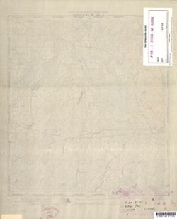
- Abstract:
- Modern area represented: Świętajno, Poland
- Call Number:
- G7000 s50 .S68 sheet N-34-91-A
- Caption:
- Captured map
- City:
- Швентайнен (Schwentainen)
- Copyright Holder:
- No Copyright - United States
- Country:
- Германия (Germany) and Восточная Пруссия (East Prussia)
- Physical Description:
- Scale: 1:50,000
- Persistent URL:
- http://purl.dlib.indiana.edu/iudl/images/VAC9619/VAC9619-000365
- Provenance:
- DMA Topographic Center, Army Map Service Library, OMAHA, Library of Congress Geography & Map Division
-
- Description:
- 1909
- Subject:
- Geographic Subject: Wielbark, Topical Subject: Maps, and Topical Subject: Soviet Union
- Publisher:
- Генеральный штаб Красной Армии
- Language:
- Russian
- Date Created:
- 1941
- Identifier:
- VAC9619-000364
- Genre:
- Military Maps and Topographic Maps
- Geographic Location:
- Coordinates: 53.3333, 20.75, 53.5, 21
- Related URL:
- Download GeoTIFF: https://drive.google.com/open?id=1HHdbX7E0cnMrubYxnxEpGa4wh1SbJai_ and Catalog URL: http://iucat.iu.edu/catalog/5020131
- Abstract:
- Modern area represented: Wielbark, Poland
- Call Number:
- G7000 s50 .S68 sheet N-34-90-D
- Caption:
- Captured map
- City:
- Вилленберг (Willenberg)
- Copyright Holder:
- No Copyright - United States
- Country:
- Восточная Пруссия (East Prussia) and Германия (Germany)
- Physical Description:
- Scale: 1:50,000
- Persistent URL:
- http://purl.dlib.indiana.edu/iudl/images/VAC9619/VAC9619-000364
- Provenance:
- DMA Topographic Center, Army Map Service Library, OMAHA, Library of Congress Geography & Map Division
-
- Subject:
- Topical Subject: Soviet Union, Topical Subject: Maps, and Geographic Subject: Muszaki
- Publisher:
- Генеральный штаб Красной Армии
- Language:
- Russian
- Date Created:
- 1941
- Identifier:
- VAC9619-000362
- Genre:
- Military Maps and Topographic Maps
- Geographic Location:
- Coordinates: 53.33333, 20.5, 53.5, 20.75
- Related URL:
- Catalog URL: http://iucat.iu.edu/catalog/5020131 and Download GeoTIFF: https://drive.google.com/open?id=1a9K-7XWGpL0pJuHj2-wg3Zvnn1eboqY6
- Abstract:
- Modern area represented: Muszaki, Poland
- Call Number:
- G7000 s50 .S68 sheet N-34-90-C
- Caption:
- Captured map
- City:
- Мушакен (Muschaken)
- Copyright Holder:
- No Copyright - United States
- Country:
- Германия (Germany) and Восточная Пруссия (East Prussia)
- State/Province:
- Область государственных интересов Германии (Region of German state interests)
- Physical Description:
- Scale: 1:50,000
- Persistent URL:
- http://purl.dlib.indiana.edu/iudl/images/VAC9619/VAC9619-000362
- Provenance:
- DMA Topographic Center, Army Map Service Library, OMAHA, Library of Congress Geography & Map Division
-
- Subject:
- Geographic Subject: Straduny, Topical Subject: Maps, and Topical Subject: Soviet Union
- Publisher:
- Генеральный штаб Красной Армии
- Language:
- Russian
- Date Created:
- 1941
- Identifier:
- VAC9619-000361
- Genre:
- Military Maps and Topographic Maps
- Geographic Location:
- Coordinates: 53.83333, 22.25, 54.0, 22.5
- Related URL:
- Catalog URL: http://iucat.iu.edu/catalog/5020131 and Download GeoTIFF: https://drive.google.com/open?id=1UwjaufrFOne5qki5XFLfUIWw3FZPIj-P
- Abstract:
- Modern area represented: Straduny, Poland
- Call Number:
- G7000 s50 .S68 sheet N-34-81-B
- Caption:
- Captured map
- City:
- Штрадаунен (Stradaunen)
- Copyright Holder:
- No Copyright - United States
- Country:
- Германия (Germany) and Восточная Пруссия (East Prussia)
- Physical Description:
- Scale: 1:50,000
- Persistent URL:
- http://purl.dlib.indiana.edu/iudl/images/VAC9619/VAC9619-000361
- Provenance:
- DMA Topographic Center, Army Map Service Library, OMAHA, Library of Congress Geography & Map Division
-

- Subject:
- Geographic Subject: Orzysz, Topical Subject: Maps, and Topical Subject: Soviet Union
- Publisher:
- Генеральный штаб Красной Армии
- Language:
- Russian
- Date Created:
- 1941
- Identifier:
- VAC9619-000360
- Genre:
- Military Maps and Topographic Maps
- Geographic Location:
- Coordinates: 53.66667, 21.75, 53.83333, 22.0
- Related URL:
- Download GeoTIFF: https://drive.google.com/open?id=1quIH8WkLZVQZYEz_078ctuyofRyy58SG and Catalog URL: http://iucat.iu.edu/catalog/5020131
- Abstract:
- Modern area represented: Orzysz, Poland
- Call Number:
- G7000 s50 .S68 sheet N-34-80-D
- City:
- Арис (Arys)
- Copyright Holder:
- No Copyright - United States
- Country:
- Восточная Пруссия (East Prussia) and Германия (Germany)
- Physical Description:
- Scale: 1:50,000
- Persistent URL:
- http://purl.dlib.indiana.edu/iudl/images/VAC9619/VAC9619-000360
- Provenance:
- DMA Topographic Center, Army Map Service Library, OMAHA, Library of Congress Geography & Map Division
-
- Subject:
- Geographic Subject: Mikołajki, Topical Subject: Soviet Union, and Topical Subject: Maps
- Publisher:
- Генеральный штаб Красной Армии
- Language:
- Russian
- Date Created:
- 1941
- Identifier:
- VAC9619-000359
- Genre:
- Military Maps and Topographic Maps
- Geographic Location:
- Coordinates: 53.66667, 21.5, 53.83333, 21.75
- Related URL:
- Catalog URL: http://iucat.iu.edu/catalog/5020131 and Download GeoTIFF: https://drive.google.com/open?id=1DQd01x2fJlk5Q0yiKB68j2ko90olJ8WE
- Abstract:
- Modern area represented: Mikołajki, Poland
- Call Number:
- G7000 s50 .S68 sheet N-34-80-C
- Caption:
- Captured map
- City:
- Николайкен (Nikolaiken)
- Copyright Holder:
- No Copyright - United States
- Country:
- Восточная Пруссия (East Prussia) and Германия (Germany)
- Physical Description:
- Scale: 1:50,000
- Persistent URL:
- http://purl.dlib.indiana.edu/iudl/images/VAC9619/VAC9619-000359
- Provenance:
- DMA Topographic Center, Army Map Service Library, OMAHA, Library of Congress Geography & Map Division
-
- Subject:
- Topical Subject: Soviet Union, Geographic Subject: Miłki, and Topical Subject: Maps
- Publisher:
- Генеральный штаб Красной Армии
- Language:
- Russian
- Date Created:
- 1941
- Identifier:
- VAC9619-000358
- Genre:
- Military Maps and Topographic Maps
- Geographic Location:
- Coordinates: 53.83333, 21.75, 54.0, 22.0
- Related URL:
- Download GeoTIFF: https://drive.google.com/open?id=1hbiMvb4V4nlVuqDWuTMru_ccs90KZXjf and Catalog URL: http://iucat.iu.edu/catalog/5020131
- Abstract:
- Modern area represented: Miłki, Poland
- Call Number:
- G7000 s50 .S68 sheet N-34-80-B
- Caption:
- Captured map
- City:
- Милькен (Milken)
- Copyright Holder:
- No Copyright - United States
- Country:
- Восточная Пруссия (East Prussia) and Германия (Germany)
- Physical Description:
- Scale: 1:50,000
- Persistent URL:
- http://purl.dlib.indiana.edu/iudl/images/VAC9619/VAC9619-000358
- Provenance:
- DMA Topographic Center, Army Map Service Library, OMAHA, Library of Congress Geography & Map Division
-
- Subject:
- Topical Subject: Maps, Geographic Subject: Kobułty, and Topical Subject: Soviet Union
- Publisher:
- Генеральный штаб Красной Армии
- Language:
- Russian
- Date Created:
- 1941
- Identifier:
- VAC9619-000357
- Genre:
- Military Maps and Topographic Maps
- Geographic Location:
- Coordinates: 53.66667, 21.0, 53.83333, 21.25
- Related URL:
- Catalog URL: http://iucat.iu.edu/catalog/5020131 and Download GeoTIFF: https://drive.google.com/open?id=1wVPptpjJn0xl6Lucnjw4Sz9mhkRXGojw
- Abstract:
- Modern area represented: Kobułty, Poland
- Call Number:
- zsheet N-34-79-C and G7000 s50 .S68
- City:
- Кобультен (Kobulten)
- Copyright Holder:
- No Copyright - United States
- Country:
- Германия (Germany) and Восточная Пруссия (East Prussia)
- Physical Description:
- Scale: 1:50,000
- Persistent URL:
- http://purl.dlib.indiana.edu/iudl/images/VAC9619/VAC9619-000357
- Provenance:
- DMA Topographic Center, Army Map Service Library, OMAHA, Library of Congress Geography & Map Division
-
- Subject:
- Geographic Subject: Biskupiec, Topical Subject: Soviet Union, and Topical Subject: Maps
- Publisher:
- Генеральный штаб Красной Армии
- Language:
- Russian
- Date Created:
- 1941
- Identifier:
- VAC9619-000356
- Genre:
- Topographic Maps and Military Maps
- Geographic Location:
- Coordinates: 53.83333, 20.75, 54.0, 21.0
- Related URL:
- Download GeoTIFF: https://drive.google.com/open?id=1DBPYnmIWIDWzPCZzhriD1LGjqvp8SUyY and Catalog URL: http://iucat.iu.edu/catalog/5020131
- Abstract:
- Modern area represented: Biskupiec, Poland
- Call Number:
- G7000 s50 .S68 sheet N-34-78-B
- City:
- Бишофсбург (Bischofsburg)
- Copyright Holder:
- No Copyright - United States
- Country:
- Восточная Пруссия (East Prussia) and Германия (Germany)
- Physical Description:
- Scale: 1:50,000
- Persistent URL:
- http://purl.dlib.indiana.edu/iudl/images/VAC9619/VAC9619-000356
- Provenance:
- DMA Topographic Center, Army Map Service Library, OMAHA, Library of Congress Geography & Map Division
-
- Subject:
- Geographic Subject: Jeziorany, Topical Subject: Soviet Union, and Topical Subject: Maps
- Publisher:
- Генеральный штаб Красной Армии
- Language:
- Russian
- Date Created:
- 1941
- Identifier:
- VAC9619-000355
- Genre:
- Military Maps and Topographic Maps
- Geographic Location:
- Coordinates: 53.83333, 20.5, 54.0, 20.75
- Related URL:
- Catalog URL: http://iucat.iu.edu/catalog/5020131 and Download GeoTIFF: https://drive.google.com/open?id=1FPb0JvKp0XiYP1vAss1DbrLTRKBkv4WD
- Abstract:
- Modern area represented: Jeziorany, Poland
- Call Number:
- G7000 s50 .S68 sheet N-34-78-A
- Caption:
- Captured map
- City:
- Зеебург (Seeburg)
- Copyright Holder:
- No Copyright - United States
- Country:
- Германия (Germany) and Восточная Пруссия (East Prussia)
- Physical Description:
- Scale: 1:50,000
- Persistent URL:
- http://purl.dlib.indiana.edu/iudl/images/VAC9619/VAC9619-000355
- Provenance:
- DMA Topographic Center, Army Map Service Library, OMAHA, Library of Congress Geography & Map Division
