
Search Constraints
Search Results
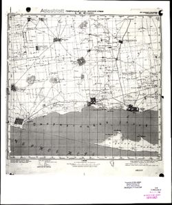
-
- Subject:
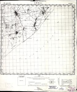
- Geographic Subject: Roslavl', Topical Subject: Soviet Union, and Topical Subject: Maps
- Publisher:
- Генеральный штаб Красной Армии
- Language:
- Russian
- Date Created:
- 1941
- Identifier:
- VAC9619-001930
- Genre:
- Military Maps and Topographic Maps
- Geographic Location:
- Coordinates: 53.6667, 32.5, 54, 33
- Related URL:
- Catalog URL: https://iucat.iu.edu/catalog/5020129 and Download GeoTIFF: https://drive.google.com/open?id=1tYWxG1_1MmG_NdkAulJjjrUlZzPyeGXt
- Abstract:
- Modern area represented: Рославль (Roslavl'), Smolenskaya oblast, Russia
- Call Number:
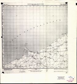
- G7000 s100 .S7 sheet N-36-78
- Caption:
- Captured map
- City:
- Рославль (Roslavl')
- Copyright Holder:
- No Copyright - United States
- Country:
- СССР (USSR)
- State/Province:
- Могилевская область (Mogilev oblast), РСФСР (RSFSR), Белорусская ССР (Byelorussian Soviet Socialist Republic), and Смоленская область (Smolensk oblast)
- Physical Description:
- Scale: 1:100,000
- Persistent URL:
- http://purl.dlib.indiana.edu/iudl/images/VAC9619/VAC9619-001930
- Provenance:
- DMA Topographic Center, Army Map Service Library, OMAHA, Library of Congress Geography & Map Division
-

- Subject:
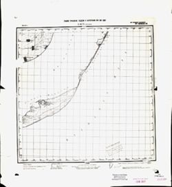
- Geographic Subject: Petrovichi, Topical Subject: Maps, and Topical Subject: Soviet Union
- Publisher:
- Генеральный штаб Красной Армии
- Language:
- Russian
- Date Created:
- 1941
- Identifier:
- VAC9619-001929
- Genre:
- Military Maps and Topographic Maps
- Geographic Location:
- Coordinates: 53.6667, 32, 54, 32.5
- Related URL:
- Catalog URL: https://iucat.iu.edu/catalog/5020129 and Download GeoTIFF: https://drive.google.com/open?id=1NuowuNe-KGOnHC6tMTsbjUOOiOYh8Zx_
- Abstract:
- Modern area represented: Петровичи (Petrovichi), Smolenskaya oblast, Russia
- Call Number:
- G7000 s100 .S7 sheet N-36-77
- City:
- Петровичи (Petrovichi)
- Copyright Holder:
- No Copyright - United States
- Country:
- СССР (USSR)
- State/Province:
- РСФСР (RSFSR), Белорусская ССР (Byelorussian Soviet Socialist Republic), Смоленская область (Smolensk oblast), and Могилевская область (Mogilev oblast)
- Physical Description:
- Scale: 1:100,000
- Persistent URL:
- http://purl.dlib.indiana.edu/iudl/images/VAC9619/VAC9619-001929
- Provenance:
- Army Map Service Library, Library of Congress G & M Division
-
- Subject:
- Topical Subject: Maps, Topical Subject: Soviet Union, and Geographic Subject: Krychaw
- Publisher:
- Генеральный штаб Красной Армии
- Language:
- Russian
- Date Created:
- 1941
- Identifier:
- VAC9619-001928
- Genre:
- Topographic Maps and Military Maps
- Geographic Location:
- Coordinates: 53.6667, 31.5, 54, 32
- Related URL:
- Download GeoTIFF: https://drive.google.com/open?id=1JxzD9LsR7YqYsS-HBjIMui0OfPZN3WDA and Catalog URL: https://iucat.iu.edu/catalog/5020129
- Abstract:
- Modern area represented: Крычаў (Krychaw), Mogilev district, Belarus
- Call Number:
- G7000 s100 .S7 sheet N-36-76
- Caption:
- Captured map
- City:
- Кричев (Krichev)
- Copyright Holder:
- No Copyright - United States
- Country:
- СССР (USSR)
- State/Province:
- Белорусская ССР (Byelorussian Soviet Socialist Republic), Смоленская область (Smolensk oblast), РСФСР (RSFSR), and Могилевская область (Mogilev oblast)
- Physical Description:
- Scale: 1:100,000
- Persistent URL:
- http://purl.dlib.indiana.edu/iudl/images/VAC9619/VAC9619-001928
- Provenance:
- DMA Topographic Center, Army Map Service Library
-
- Description:
- 1899
- Subject:
- Topical Subject: Soviet Union, Topical Subject: Maps, and Geographic Subject: Slavne
- Publisher:
- Генеральный штаб Красной Армии
- Language:
- Russian
- Date Created:
- 1941
- Identifier:
- VAC9619-001927
- Genre:
- Military Maps and Topographic Maps
- Geographic Location:
- Coordinates: 45.6667, 33, 46, 33.5
- Related URL:
- Catalog URL: https://iucat.iu.edu/catalog/5020129 and Download GeoTIFF: https://drive.google.com/open?id=18d2YDe94-hXEd9X6UYYnpuKQUZoK9pxF
- Abstract:
- Modern area represented: Slavne, Republic of Crimea, Ukraine
- Call Number:
- G7000 s100 .S7 sheet L-36-79
- Caption:
- Для cлужебного пользования
- City:
- Бакал (Bakal)
- Copyright Holder:
- No Copyright - United States
- Country:
- СССР (USSR)
- State/Province:
- РСФСР (RSFSR) and Крымская АССР (Crimean Autonomous Soviet Socialist Republic)
- Physical Description:
- Scale: 1:100,000
- Persistent URL:
- http://purl.dlib.indiana.edu/iudl/images/VAC9619/VAC9619-001927
- Provenance:
- CIA Map Library
-
- Description:
- 1884
- Subject:
- Topical Subject: Maps, Topical Subject: Soviet Union, and Geographic Subject: Shyroke
- Publisher:
- Генеральный штаб Красной Армии
- Language:
- Russian
- Date Created:
- 1916
- Identifier:
- VAC9619-001926
- Genre:
- Military Maps and Topographic Maps
- Geographic Location:
- Coordinates: 45.6667, 30, 46, 30.5
- Related URL:
- Download GeoTIFF: https://drive.google.com/file/d/1AYaNyRovEw9oylsdtjC4JxGB1IgJmmQs/view?usp=sharing and Catalog URL: https://iucat.iu.edu/catalog/5020129
- Abstract:
- Modern area represented: Shyroke, Odessa oblast, Ukraine
- Call Number:
- G7000 s100 .S7 sheet L-36-73
- Caption:
- Для служебного пользования
- City:
- Кебабча (Kebabcha)
- Copyright Holder:
- No Copyright - United States
- Country:
- СССР (USSR)
- State/Province:
- Украинская ССР (Ukrainian Soviet Socialist Republic) and Аккерманская область (Akkerman oblast)
- Physical Description:
- Scale: 1:100,000
- Persistent URL:
- http://purl.dlib.indiana.edu/iudl/images/VAC9619/VAC9619-001926
- Provenance:
- DMA Topographic Center, Army Map Service Library, OMAHA
-
- Description:
- 1884
- Subject:
- Geographic Subject: Shyroke, Topical Subject: Soviet Union, and Topical Subject: Maps
- Publisher:
- Управление военных топографов РККА
- Language:
- Russian
- Date Created:
- 1916
- Identifier:
- VAC9619-001925
- Genre:
- Military Maps and Topographic Maps
- Geographic Location:
- Coordinates: 45.6667, 30, 46, 30.5
- Related URL:
- Download GeoTIFF: https://drive.google.com/open?id=1iPfmTs__rEimlzKp73T30v5fMa4py_Lz and Catalog URL: https://iucat.iu.edu/catalog/5020129
- Abstract:
- Modern area represented: Shyroke, Odessa oblast, Ukraine
- Call Number:
- G7000 s100 .S7 sheet L-36-73
- City:
- Кебабча (Kebabcha)
- Copyright Holder:
- No Copyright - United States
- State/Province:
- Бессарабия (Bessarabia)
- Physical Description:
- Scale: 1:100,000
- Persistent URL:
- http://purl.dlib.indiana.edu/iudl/images/VAC9619/VAC9619-001925
- Provenance:
- CIA Map Library
-
- Description:
- 1934
- Subject:
- Topical Subject: Soviet Union, Topical Subject: Maps, and Geographic Subject: Noviy Azov
- Publisher:
- Главное Управление Геодезии и Картографии при СНК СССР
- Language:
- Russian
- Date Created:
- 1936
- Identifier:
- VAC9619-001924
- Genre:
- Topographic Maps and Military Maps
- Geographic Location:
- Coordinates: 46, 35, 46.3333, 35.5
- Related URL:
- Download GeoTIFF: https://drive.google.com/open?id=1kXYrv1G8OZSvZdSM2SJdkDOcDlraF50I and Catalog URL: https://iucat.iu.edu/catalog/5020129
- Abstract:
- Modern area represented: Noviy Azov, Kherson oblast, Ukraine
- Call Number:
- G7000 s100 .S7 sheet L-36-71
- Caption:
- Для служебного пользования
- City:
- Нов. Азов (Noviy Azov)
- Copyright Holder:
- No Copyright - United States
- Country:
- СССР (USSR)
- State/Province:
- Запорожская область (Zaporizhia oblast) and Украинская ССР (Ukrainian Soviet Socialist Republic)
- Physical Description:
- Scale: 1:100,000
- Persistent URL:
- http://purl.dlib.indiana.edu/iudl/images/VAC9619/VAC9619-001924
- Provenance:
- CIA Map Library
-
- Description:
- 1933
- Subject:
- Geographic Subject: Hromivka, Topical Subject: Soviet Union, and Topical Subject: Maps
- Publisher:
- Генеральный штаб Красной Армии
- Language:
- Russian
- Date Created:
- 1941
- Identifier:
- VAC9619-001923
- Genre:
- Topographic Maps and Military Maps
- Geographic Location:
- Coordinates: 46, 34, 46.3333, 34.5
- Related URL:
- Download GeoTIFF: https://drive.google.com/open?id=1sOMPSRT5vHzGSJy5FqPqnkWmkwqYR5YH and Catalog URL: https://iucat.iu.edu/catalog/5020129
- Abstract:
- Modern area represented: Hromivka, Kherson oblast, Ukraine
- Call Number:
- G7000 s100 .S7 sheet L-36-69
- Caption:
- Для служебного пользования
- City:
- Громовка (Gromovka)
- Copyright Holder:
- No Copyright - United States
- Country:
- СССР (USSR)
- State/Province:
- Украинская ССР (Ukrainian Soviet Socialist Republic), Крымская АССР (Crimean Autonomous Soviet Socialist Republic), Запорожская область (Zaporizhia oblast), ...
- Physical Description:
- Scale: 1:100,000
- Persistent URL:
- http://purl.dlib.indiana.edu/iudl/images/VAC9619/VAC9619-001923
- Provenance:
- CIA Map Library
-
- Description:
- 1920
- Subject:
- Geographic Subject: Kalanchak, Topical Subject: Soviet Union, and Topical Subject: Maps
- Publisher:
- Генеральный штаб Красной Армии
- Language:
- Russian
- Date Created:
- 1941
- Identifier:
- VAC9619-001922
- Genre:
- Military Maps and Topographic Maps
- Geographic Location:
- Coordinates: 46, 33, 46.3333, 33.5
- Related URL:
- Download GeoTIFF: https://drive.google.com/open?id=10xl3isSWbQilOsNbPqZ3aF60od59QIm4 and Catalog URL: https://iucat.iu.edu/catalog/5020129
- Abstract:
- Modern area represented: Kalanchak, Kherson oblast, Ukraine
- Call Number:
- G7000 s100 .S7 sheet L-36-67
- Caption:
- Для служебного пользования
- City:
- Каланчак (Kalanchak)
- Copyright Holder:
- No Copyright - United States
- Country:
- СССР (USSR)
- State/Province:
- Украинская ССР (Ukrainian Soviet Socialist Republic) and Николаевская область (Mykolaiv oblast)
- Physical Description:
- Scale: 1:100,000
- Persistent URL:
- http://purl.dlib.indiana.edu/iudl/images/VAC9619/VAC9619-001922
- Provenance:
- DMA Topographic Center, Army Map Service Library, OMAHA
-
- Description:
- 1941
- Subject:
- Topical Subject: Maps, Topical Subject: Soviet Union, and Geographic Subject: Skadowsk
- Publisher:
- Генеральный штаб Красной Армии
- Language:
- Russian
- Identifier:
- VAC9619-001921
- Genre:
- Military Maps and Topographic Maps
- Geographic Location:
- Coordinates: 46, 32.5, 46.3333, 33
- Related URL:
- Catalog URL: https://iucat.iu.edu/catalog/5020129 and Download GeoTIFF: https://drive.google.com/file/d/1xtbzarw03n6d4ePGPcTdYxMxETtBFgmw/view?usp=sharing
- Abstract:
- Modern area represented: Skadowsk, Kherson oblast, Ukraine
- Call Number:
- G7000 s100 .S7 sheet L-36-66
- Caption:
- Для служебного пользования
- City:
- Скадовск (Skadowsk)
- Copyright Holder:
- No Copyright - United States
- Country:
- СССР (USSR)
- State/Province:
- Украинская ССР (Ukrainian Soviet Socialist Republic)
- Physical Description:
- Scale: 1:100,000
- Persistent URL:
- http://purl.dlib.indiana.edu/iudl/images/VAC9619/VAC9619-001921
- Provenance:
- CIA Map Library, Atlasblatt
