
Search Constraints
You searched for:
Country
СССР (USSR)
Remove constraint Country: СССР (USSR)
Provenance
M. I. Map Library
Remove constraint Provenance: M. I. Map Library
« Previous |
1 - 50 of 55
|
Next »
Search Results
-
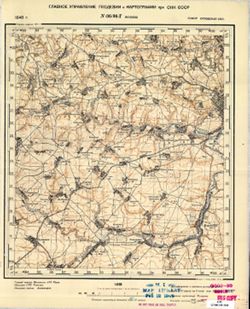
- Description:
- 1940
- Subject:
- Topical Subject: Soviet Union, Geographic Subject: Bolkhov, and Topical Subject: Maps
- Publisher:
- Главное Управление Геодезии и Картографии при СНК СССР
- Language:
- Russian
- Date Created:
- 1941
- Identifier:
- VAC9619-001478
- Genre:
- Military Maps and Topographic Maps
- Geographic Location:
- Coordinates: 53.3333, 35.75, 53.5, 36
- Related URL:
- Catalog URL: http://iucat.iu.edu/catalog/5020131 and Download GeoTIFF: https://drive.google.com/open?id=14GGU-2tZQhcnZj2XMD6SOTLnhCnhaWpk
- Abstract:
- Modern area represented: Bolkhov, Oryol oblast, Russia
- Call Number:
- G7000 s50 .S68 sheet N-36-96-D
- City:
- Болхов (Bolkhov)
- Copyright Holder:
- No Copyright - United States
- Country:
- СССР (USSR)
- State/Province:
- РСФСР (RSFSR) and Орловская область (Oryol oblast)
- Physical Description:
- Scale: 1:50,000
- Persistent URL:
- http://purl.dlib.indiana.edu/iudl/images/VAC9619/VAC9619-001478
- Provenance:
- M. I. Map Library
-
- Description:
- 1923
- Subject:
- Topical Subject: Maps, Geographic Subject: Chavusi, and Topical Subject: Soviet Union
- Publisher:
- Управление военных топографов
- Language:
- Russian
- Date Created:
- 1926
- Identifier:
- VAC9619-001402
- Genre:
- Topographic Maps and Military Maps
- Geographic Location:
- Coordinates: 53.667, 30.75, 53.833, 31
- Related URL:
- Catalog URL: http://iucat.iu.edu/catalog/5020131 and Download GeoTIFF: https://drive.google.com/open?id=19RCJP_F7aEs1hzwZ1krEnOEdA-MdnvHR
- Abstract:
- Modern area represented: Chavusi, Mogilev oblast, Belarus
- Call Number:
- GM G7000 S50 .S68 N-36-74-Г
- Caption:
- Не подлежит оглашению
- City:
- Чаусы (Chavusi)
- Copyright Holder:
- No Copyright - United States
- Country:
- СССР (USSR)
- State/Province:
- Белорусская ССР (Byelorussian Soviet Socialist Republic)
- Physical Description:
- Scale: 1:50,000
- Persistent URL:
- http://purl.dlib.indiana.edu/iudl/images/VAC9619/VAC9619-001402
- Provenance:
- M. I. Map Library
-
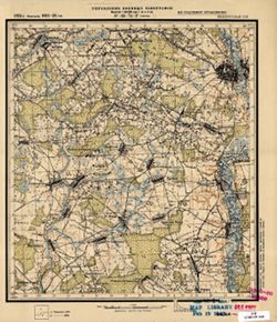
- Description:
- 1929
- Subject:
- Geographic Subject: Goleni, Topical Subject: Soviet Union, and Topical Subject: Maps
- Publisher:
- Военно-топографическое управление
- Language:
- Russian
- Identifier:
- VAC9619-001401
- Genre:
- Military Maps and Topographic Maps
- Geographic Location:
- Coordinates: 53.667, 30.5, 53.833, 30.75
- Related URL:
- Catalog URL: http://iucat.iu.edu/catalog/5020131 and Download GeoTIFF: https://drive.google.com/open?id=1BV4Dwp8i4A8x77fOV4CI3WD0Vl_svmlS
- Abstract:
- Modern area represented: Goleni, Mogilev oblast, Belarus
- Call Number:
- GM G7000 S50 .S68 N-36-74-B
- Caption:
- Секретно
- City:
- Голени (Goleni)
- Copyright Holder:
- No Copyright - United States
- Country:
- СССР (USSR)
- State/Province:
- Белорусская ССР (Byelorussian Soviet Socialist Republic) and Могилевский округ (Mogilev district)
- Physical Description:
- Scale: 1:50,000
- Persistent URL:
- http://purl.dlib.indiana.edu/iudl/images/VAC9619/VAC9619-001401
- Provenance:
- M. I. Map Library
-
- Subject:
- Topical Subject: Soviet Union, Geographic Subject: Veiveriai, and Topical Subject: Maps
- Publisher:
- Генеральный штаб Красной Армии
- Language:
- Russian
- Date Created:
- 1941
- Identifier:
- VAC9619-003723
- Genre:
- Military Maps and Topographic Maps
- Geographic Location:
- Coordinates: 54.75, 23.625, 54.875, 23.75
- Related URL:
- Catalog URL: https://iucat.iu.edu/catalog/14701157 and Download GeoTIFF: https://drive.google.com/file/d/1nnb2K3KSqYEadwS2uEuWXtn2wrG-yvPS/view?usp=sharing
- Abstract:
- Modern area represented: Veiveriai, Lithuania
- Call Number:
- G7063.K2 s25 .S6 sheet N-34-48-C-b
- Caption:
- Секретно
- City:
- Вейверы (Veyvery)
- Copyright Holder:
- No Copyright - United States
- Country:
- СССР (USSR)
- State/Province:
- Литовская ССР (Lithuanian Soviet Socialist Republic)
- Physical Description:
- Scale: 1:25,000
- Persistent URL:
- http://purl.dlib.indiana.edu/iudl/images/VAC9619/VAC9619-003723
- Provenance:
- M. I. Map Library
-
- Subject:
- Topical Subject: Soviet Union, Topical Subject: Maps, and Geographic Subject: Didieji Ibėnai
- Publisher:
- Генеральный штаб Красной Армии
- Language:
- Russian
- Date Created:
- 1941
- Identifier:
- VAC9619-003635
- Genre:
- Military Maps and Topographic Maps
- Geographic Location:
- Coordinates: 55, 23.875, 55.083, 24
- Related URL:
- Catalog URL: https://iucat.iu.edu/catalog/14701157 and Download GeoTIFF: https://drive.google.com/file/d/1tupUHbpChdC5mnOsJmV22NSUxvuLLwGp/view?usp=sharing
- Abstract:
- Modern area represented: Didieji Ibėnai, Lithuania
- Call Number:
- G7063.K2 s25 .S6 sheet N-34-36-D-d
- Caption:
- Секретно
- City:
- Никольская (Nikol’skaya)
- Copyright Holder:
- No Copyright - United States
- Country:
- СССР (USSR)
- State/Province:
- Литовская ССР (Lithuanian Soviet Socialist Republic)
- Physical Description:
- Scale: 1:25,000
- Persistent URL:
- http://purl.dlib.indiana.edu/iudl/images/VAC9619/VAC9619-003635
- Provenance:
- M. I. Map Library
-
- Subject:
- Topical Subject: Maps, Topical Subject: Soviet Union, and Geographic Subject: Muniškiai
- Publisher:
- Генеральный штаб Красной Армии
- Language:
- Russian
- Date Created:
- 1941
- Identifier:
- VAC9619-003634
- Genre:
- Military Maps and Topographic Maps
- Geographic Location:
- Coordinates: 55, 23.75, 55.083, 23.875
- Related URL:
- Download GeoTIFF: https://drive.google.com/file/d/1RSHjF8sA7nONXJFs4vMmAN6eP3uezOJd/view?usp=sharing and Catalog URL: https://iucat.iu.edu/catalog/14701157
- Abstract:
- Modern area represented: Muniškiai, Lithuania
- Call Number:
- G7063.K2 s25 .S6 sheet N-34-36-D-c
- Caption:
- Секретно
- City:
- Мунишканцы (Munishkantsy)
- Copyright Holder:
- No Copyright - United States
- Country:
- СССР (USSR)
- State/Province:
- Литовская ССР (Lithuanian Soviet Socialist Republic)
- Physical Description:
- Scale: 1:25,000
- Persistent URL:
- http://purl.dlib.indiana.edu/iudl/images/VAC9619/VAC9619-003634
- Provenance:
- M. I. Map Library
-
- Subject:
- Topical Subject: Soviet Union, Geographic Subject: Lygainiai, and Topical Subject: Maps
- Publisher:
- Генеральный штаб Красной Армии
- Language:
- Russian
- Date Created:
- 1941
- Identifier:
- VAC9619-003631
- Genre:
- Military Maps and Topographic Maps
- Geographic Location:
- Coordinates: 55, 23.625, 55.083, 23.75
- Related URL:
- Download GeoTIFF: https://drive.google.com/file/d/1S2wLZFzyMw9G1AZTYyk76tctZv36Q1Ml/view?usp=sharing and Catalog URL: https://iucat.iu.edu/catalog/14701157
- Abstract:
- Modern area represented: Lygainiai, Lithuania
- Call Number:
- G7063.K2 s25 .S6 sheet N-34-36-C-d
- Caption:
- Секретно
- City:
- Лигайне (Ligayne)
- Copyright Holder:
- No Copyright - United States
- Country:
- СССР (USSR)
- State/Province:
- Литовская ССР (Lithuanian Soviet Socialist Republic)
- Physical Description:
- Scale: 1:25,000
- Persistent URL:
- http://purl.dlib.indiana.edu/iudl/images/VAC9619/VAC9619-003631
- Provenance:
- M. I. Map Library
-
- Subject:
- Geographic Subject: Krakės, Topical Subject: Soviet Union, and Topical Subject: Maps
- Publisher:
- Генеральный штаб Красной Армии
- Language:
- Russian
- Date Created:
- 1941
- Identifier:
- VAC9619-003583
- Genre:
- Topographic Maps and Military Maps
- Geographic Location:
- Coordinates: 55.333, 23.625, 55.417, 23.75
- Related URL:
- Download GeoTIFF: https://drive.google.com/file/d/19Cr2qI4RqBkehkyBa1nvsuagjpFFQlbF/view?usp=sharing and Catalog URL: https://iucat.iu.edu/catalog/14701157
- Abstract:
- Modern area represented: Krakės, Lithuania
- Call Number:
- G7063.K2 s25 .S6 sheet N-34-24-C-d
- Caption:
- Секретно
- City:
- Кроки (Kroki)
- Copyright Holder:
- No Copyright - United States
- Country:
- СССР (USSR)
- State/Province:
- Литовская ССР (Lithuanian Soviet Socialist Republic)
- Physical Description:
- Scale: 1:25,000
- Persistent URL:
- http://purl.dlib.indiana.edu/iudl/images/VAC9619/VAC9619-003583
- Provenance:
- M. I. Map Library
-
- Description:
- 1927
- Subject:
- Topical Subject: Soviet Union, Geographic Subject: Kovali, and Topical Subject: Maps
- Publisher:
- Управление военных топографов
- Language:
- Russian
- Identifier:
- VAC9619-003494
- Genre:
- Topographic Maps and Military Maps
- Geographic Location:
- Coordinates: 56.0, 31.75, 56.16667, 32.0
- Related URL:
- Download GeoTIFF: https://drive.google.com/file/d/1aUs01744U8z9WJUyVwJHJ7uEfI1G5EIX/view?usp=sharing and Catalog URL: http://iucat.iu.edu/catalog/5020131
- Abstract:
- Modern area represented: Ковали (Kovali), Tverskaya oblast, Russia
- Call Number:
- G7000 s50 .S68 sheet O-36-136-D
- Caption:
- Не подлежит оглашению
- City:
- Ковали (Kovali)
- Copyright Holder:
- No Copyright - United States
- Country:
- СССР (USSR)
- State/Province:
- РСФСР (RSFSR) and Западная область (Western oblast)
- Physical Description:
- Scale: 1:50,000
- Persistent URL:
- http://purl.dlib.indiana.edu/iudl/images/VAC9619/VAC9619-003494
- Provenance:
- M. I. Map Library
-

- Subject:
- Topical Subject: Soviet Union, Geographic Subject: Trushkovo, and Topical Subject: Maps
- Publisher:
- Управление военных топографов
- Language:
- Russian
- Date Created:
- 1931
- Identifier:
- VAC9619-003483
- Genre:
- Military Maps and Topographic Maps
- Geographic Location:
- Coordinates: 56, 30, 56.167, 30.25
- Related URL:
- Download GeoTIFF: https://drive.google.com/file/d/1F9AHdWYQlqmtkTiBR4olg1MOZEsEhO3c/view?usp=sharing and Catalog URL: http://iucat.iu.edu/catalog/5020131
- Abstract:
- Modern area represented: Трушково (Trushkovo), Pskovskaya oblast, Russia
- Call Number:
- G7000 s50 .S68 sheet O-36-133-C
- Caption:
- Не подлежит оглашению
- City:
- Трушкова (Trushkova)
- Copyright Holder:
- No Copyright - United States
- Country:
- СССР (USSR)
- State/Province:
- Западная область (Western oblast) and РСФСР (RSFSR)
- Physical Description:
- Scale: 1:50,000
- Persistent URL:
- http://purl.dlib.indiana.edu/iudl/images/VAC9619/VAC9619-003483
- Provenance:
- M. I. Map Library
-
- Subject:
- Topical Subject: Maps, Geographic Subject: Mordovichi, and Topical Subject: Soviet Union
- Publisher:
- Военно-топографическое управление
- Language:
- Russian
- Identifier:
- VAC9619-003481
- Genre:
- Military Maps and Topographic Maps
- Geographic Location:
- Coordinates: 56.167, 30.25, 56.333, 30.5
- Related URL:
- Download GeoTIFF: https://drive.google.com/file/d/1sY6hntrqKdah00xa6GFpl1pQ1wwGGLia/view?usp=sharing and Catalog URL: http://iucat.iu.edu/catalog/5020131
- Abstract:
- Modern area represented: Мордовичи (Mordovichi), Pskovskaya oblast, Russia
- Call Number:
- G7000 s50 .S68 sheet O-36-133-B
- Caption:
- Не подлежит оглашению
- City:
- Мордовищи (Mordovishchi)
- Copyright Holder:
- No Copyright - United States
- Country:
- СССР (USSR)
- State/Province:
- Западная область (Western oblast) and РСФСР (RSFSR)
- Physical Description:
- Scale: 1:50,000
- Persistent URL:
- http://purl.dlib.indiana.edu/iudl/images/VAC9619/VAC9619-003481
- Provenance:
- M. I. Map Library
-
- Subject:
- Topical Subject: Soviet Union, Geographic Subject: Zakharovo, and Topical Subject: Maps
- Publisher:
- Управление военных топографов РККА
- Language:
- Russian
- Identifier:
- VAC9619-003479
- Genre:
- Military Maps and Topographic Maps
- Geographic Location:
- Coordinates: 56.167, 30, 56.333, 30.25
- Related URL:
- Download GeoTIFF: https://drive.google.com/file/d/18qVdwAsXlKVJqWQ87u7VFZ3iwvTgaxI9/view?usp=sharing and Catalog URL: http://iucat.iu.edu/catalog/5020131
- Abstract:
- Modern area represented: Захарово (Zakharovo), Tverskaya oblast, Russia
- Call Number:
- G7000 s50 .S68 sheet O-36-133-A
- Caption:
- Не подлежит оглашению
- City:
- Захарова (Zakharova)
- Copyright Holder:
- No Copyright - United States
- Country:
- СССР (USSR)
- State/Province:
- Калининская область (Kalinin oblast) and РСФСР (RSFSR)
- Physical Description:
- Scale: 1:50,000
- Persistent URL:
- http://purl.dlib.indiana.edu/iudl/images/VAC9619/VAC9619-003479
- Provenance:
- M. I. Map Library
-
- Description:
- 1938
- Subject:
- Geographic Subject: Dvorishchi, Topical Subject: Soviet Union, and Topical Subject: Maps
- Publisher:
- Главное управление геодезии и картографии при СНК СССР
- Language:
- Russian
- Identifier:
- VAC9619-003371
- Genre:
- Military Maps and Topographic Maps
- Geographic Location:
- Coordinates: 58.5, 32.25, 58.667, 32.5
- Related URL:
- Catalog URL: http://iucat.iu.edu/catalog/5020131 and Download GeoTIFF: https://drive.google.com/file/d/1g824LzZlf3RRWsdzTBr8h7RVARtfdI_k/view?usp=sharing
- Abstract:
- Modern area represented: Дворищи (Dvorishchi), Novgorodskaya oblast, Russia
- Call Number:
- G7000 s50 .S68 sheet O-36-53-B
- Caption:
- Для служебного пользования
- City:
- Дворищи (Dvorishchi)
- Copyright Holder:
- No Copyright - United States
- Country:
- СССР (USSR)
- State/Province:
- Ленинградская область (Leningrad oblast), Маловишерский район (Malovishersky district), and Крестецкий район (Krestetsky district)
- Physical Description:
- Scale: 1:50,000
- Persistent URL:
- http://purl.dlib.indiana.edu/iudl/images/VAC9619/VAC9619-003371
- Provenance:
- M. I. Map Library
-
- Description:
- 1938
- Subject:
- Topical Subject: Soviet Union, Geographic Subject: Krasnyye Stanki, and Topical Subject: Maps
- Publisher:
- Главное управление государственной съемки и картографии НКВД СССР
- Language:
- Russian
- Identifier:
- VAC9619-003369
- Genre:
- Military Maps and Topographic Maps
- Geographic Location:
- Coordinates: 58.333, 31.75, 58.5, 32
- Related URL:
- Catalog URL: http://iucat.iu.edu/catalog/5020131 and Download GeoTIFF: https://drive.google.com/file/d/1wW7qF7R81RNq_wPLkVNQc2tuueM2oPrI/view?usp=sharing
- Abstract:
- Modern area represented: Красные Станки (Krasnyye Stanki), Novgorodskaya oblast, Russia
- Call Number:
- G7000 s50 .S68 sheet O-36-52-D
- Caption:
- Для служебного пользования
- City:
- Красные Станки (Krasnyye Stanki)
- Copyright Holder:
- No Copyright - United States
- Country:
- СССР (USSR)
- State/Province:
- Ленинградская область (Leningrad oblast), Новгородский район (Novgorod district), and Крестецкий район (Krestetsky district)
- Physical Description:
- Scale: 1:50,000
- Persistent URL:
- http://purl.dlib.indiana.edu/iudl/images/VAC9619/VAC9619-003369
- Provenance:
- M. I. Map Library
-
- Description:
- 1936
- Subject:
- Topical Subject: Maps, Geographic Subject: Nebolchi, and Topical Subject: Soviet Union
- Publisher:
- Главное управление государственной съемки и картографии НКВД СССР
- Language:
- Russian
- Identifier:
- VAC9619-003334
- Genre:
- Topographic Maps and Military Maps
- Geographic Location:
- Coordinates: 59, 33.25, 59.167, 33.5
- Related URL:
- Download GeoTIFF: https://drive.google.com/file/d/1vGh2-yuT-8k4jaMerbro2YequRRCtkG_/view?usp=sharing and Catalog URL: http://iucat.iu.edu/catalog/5020131
- Abstract:
- Modern area represented: Неболчи (Nebolchi), Novgorodskaya oblast, Russia
- Call Number:
- G7000 s50 .S68 sheet O-36-31-D
- Caption:
- Для служебного пользования
- City:
- Неболчи (Nebolchi)
- Copyright Holder:
- No Copyright - United States
- Country:
- СССР (USSR)
- State/Province:
- Любытинский район (Lyubytinsky district), РСФСР (RSFSR), Дрегельский район (Dregelsky district), and Ленинградская область (Leningrad oblast)
- Physical Description:
- Scale: 1:50,000
- Persistent URL:
- http://purl.dlib.indiana.edu/iudl/images/VAC9619/VAC9619-003334
- Provenance:
- M. I. Map Library
-
- Description:
- 1936
- Subject:
- Geographic Subject: Zobishchi, Topical Subject: Soviet Union, and Topical Subject: Maps
- Publisher:
- Главное управление государственной съемки и картографии НКВД СССР
- Language:
- Russian
- Identifier:
- VAC9619-003331
- Genre:
- Topographic Maps and Military Maps
- Geographic Location:
- Coordinates: 59.167, 33, 59.333, 33.25
- Related URL:
- Catalog URL: http://iucat.iu.edu/catalog/5020131 and Download GeoTIFF: https://drive.google.com/file/d/1Jhg2Tj7hINVBD96Uc7O27K8ARG3-xpsB/view?usp=sharing
- Abstract:
- Modern area represented: Зобищи (Zobishchi), Novgorodskaya oblast, Russia
- Call Number:
- G7000 s50 .S68 sheet O-36-31-A
- Caption:
- Для служебного пользования
- City:
- Зобище (Zobishche)
- Copyright Holder:
- No Copyright - United States
- Country:
- СССР (USSR)
- State/Province:
- Дрегельский район (Dregelsky district), РСФСР (RSFSR), and Ленинградская область (Leningrad oblast)
- Physical Description:
- Scale: 1:50,000
- Persistent URL:
- http://purl.dlib.indiana.edu/iudl/images/VAC9619/VAC9619-003331
- Provenance:
- M. I. Map Library
-
- Description:
- 1936
- Subject:
- Topical Subject: Maps, Topical Subject: Soviet Union, and Geographic Subject: Glad'
- Publisher:
- Главное управление государственной съемки и картографии НКВД СССР
- Language:
- Russian
- Date Created:
- 1941
- Identifier:
- VAC9619-003326
- Genre:
- Military Maps and Topographic Maps
- Geographic Location:
- Coordinates: 59, 32, 59.167, 32.25
- Related URL:
- Catalog URL: http://iucat.iu.edu/catalog/5020131 and Download GeoTIFF: https://drive.google.com/file/d/1uQeqSrfffRYdboAdTqPVTHEerJ_HHoQF/view?usp=sharing
- Abstract:
- Modern area represented: Гладь (Glad'), Novgorodskaya oblast, Russia
- Call Number:
- G7000 s50 .S68 sheet O-36-29-C
- Caption:
- Для служебного пользования
- City:
- Гладь (Glad')
- Copyright Holder:
- No Copyright - United States
- Country:
- СССР (USSR)
- State/Province:
- Чудовский район (Chudovsky district), Маловишерский район (Malovishersky district), РСФСР (RSFSR), and Ленинградская область (Leningrad oblast)
- Physical Description:
- Scale: 1:50,000
- Persistent URL:
- http://purl.dlib.indiana.edu/iudl/images/VAC9619/VAC9619-003326
- Provenance:
- M. I. Map Library
-
- Description:
- 1937
- Subject:
- Topical Subject: Maps, Geographic Subject: Vditsko, and Topical Subject: Soviet Union
- Publisher:
- Главное управление государственной съемки и картографии НКВД СССР
- Language:
- Russian
- Date Created:
- 1941
- Identifier:
- VAC9619-003317
- Genre:
- Military Maps and Topographic Maps
- Geographic Location:
- Coordinates: 59, 31, 59.167, 31.25
- Related URL:
- Catalog URL: http://iucat.iu.edu/catalog/5020131 and Download GeoTIFF: https://drive.google.com/file/d/1NM_x_MjJDqMX13qR8VPd7sFKdkVst2LK/view?usp=sharing
- Abstract:
- Modern area represented: Вдицко (Vditsko), Novgorodskaya oblast, Russia
- Call Number:
- G7000 s50 .S68 sheet O-36-27-C
- Caption:
- Captured map and Секретно
- City:
- Вдицко (Vditsko)
- Copyright Holder:
- No Copyright - United States
- Country:
- СССР (USSR)
- State/Province:
- РСФСР (RSFSR), Тосненский район (Tosnensky district), Ленинградская область (Leningrad oblast), and Новгородский район (Novgorod district)
- Physical Description:
- Scale: 1:50,000
- Persistent URL:
- http://purl.dlib.indiana.edu/iudl/images/VAC9619/VAC9619-003317
- Provenance:
- M. I. Map Library
-
- Description:
- 1938
- Subject:
- Topical Subject: Maps, Topical Subject: Soviet Union, and Geographic Subject: Polomenitsy
- Publisher:
- Главное управление геодезии и картографии при СНК СССР
- Language:
- Russian
- Date Created:
- 1941
- Identifier:
- VAC9619-002904
- Genre:
- Military Maps and Topographic Maps
- Geographic Location:
- Coordinates: 56.667, 35, 56.833, 35.25
- Related URL:
- Catalog URL: http://iucat.iu.edu/catalog/5020131 and Download GeoTIFF: https://drive.google.com/file/d/1_WPD2YySqDnn5ZOBE2eLEB6FMHHGimLb/view?usp=sharing
- Abstract:
- Modern area represented: Поломеницы (Polomenitsy), Tverskaya oblast, Russia
- Call Number:
- GM G7000 s50 .S68 sheet O-36-119-C
- City:
- Поломеницы (Polomenitsy)
- Copyright Holder:
- No Copyright - United States
- Country:
- СССР (USSR)
- State/Province:
- Емельяновский район (Yemelyanovsky district), Высоковский район (Vysokovsky district), Медновский район (Mednovsky district), and Калининская область (Kalini...
- Physical Description:
- Scale: 1:50,000
- Persistent URL:
- http://purl.dlib.indiana.edu/iudl/images/VAC9619/VAC9619-002904
- Provenance:
- M. I. Map Library
-

- Description:
- 1932
- Subject:
- Topical Subject: Maps, Geographic Subject: Норинськ (Noryns’k), and Topical Subject: Soviet Union
- Publisher:
- Управление военных топографов
- Language:
- Russian
- Identifier:
- VAC9619-002919
- Genre:
- Topographic Maps and Military Maps
- Geographic Location:
- Coordinates: 51.167, 28.5, 51.333, 28.75
- Related URL:
- Catalog URL: http://iucat.iu.edu/catalog/5020131 and Download GeoTIFF: https://drive.google.com/file/d/13PS6S7tMgGyodhBlwoTux1o3yrljPpfl/view?usp=sharing
- Abstract:
- Modern area represented: Норинськ (Noryns’k), Zhytomyr Oblast, Ukraine
- Call Number:
- G7000 s50 .S68 sheet M-35-34-A
- Caption:
- Не подлежит оглашению
- City:
- Норинск (Norinsk)
- Copyright Holder:
- No Copyright - United States
- Country:
- СССР (USSR)
- State/Province:
- Киевская область (Kyiv oblast) and Украинская ССР (Ukrainian Soviet Socialist Republic)
- Physical Description:
- Scale: 1:50,000
- Persistent URL:
- http://purl.dlib.indiana.edu/iudl/images/VAC9619/VAC9619-002919
- Provenance:
- M. I. Map Library
-
- Description:
- 1938
- Subject:
- Geographic Subject: Likhoslavl', Topical Subject: Soviet Union, and Topical Subject: Maps
- Publisher:
- Главное управление геодезии и картографии при СНК СССР
- Language:
- Russian
- Date Created:
- 1941
- Identifier:
- VAC9619-002852
- Genre:
- Military Maps and Topographic Maps
- Geographic Location:
- Coordinates: 57, 35.25, 57.167, 35.5
- Related URL:
- Download GeoTIFF: https://drive.google.com/file/d/1_1d7nZrOWqXaKo7w86AM92cd9KGEpK5Y/view?usp=sharing and Catalog URL: http://iucat.iu.edu/catalog/5020131
- Abstract:
- Modern area represented: Лихославль (Likhoslavl'), Тверская область (Tverskaya oblast), Russia
- Call Number:
- GM G7000 s50 .S68 sheet O-36-107-D
- City:
- Лихославль (Likhoslavl')
- Copyright Holder:
- No Copyright - United States
- Country:
- СССР (USSR)
- State/Province:
- Новоторжский район (Novotorzhsky district), Лихославльский район (Likhoslavlsky district), Калининская область (Kalinin oblast), and Медновский район (Mednov...
- Physical Description:
- Scale: 1:50,000
- Persistent URL:
- http://purl.dlib.indiana.edu/iudl/images/VAC9619/VAC9619-002852
- Provenance:
- M. I. Map Library
-
- Description:
- 1936
- Subject:
- Geographic Subject: Балашэвічы (Balashevichy), Topical Subject: Maps, and Topical Subject: Soviet Union
- Publisher:
- Управление военных топографов РККА
- Language:
- Russian
- Identifier:
- VAC9619-002822
- Genre:
- Military Maps and Topographic Maps
- Geographic Location:
- Coordinates: 52.833, 28.75, 53, 29
- Related URL:
- Download GeoTIFF: https://drive.google.com/file/d/17oVb7cVd5S17Sty5ZHUCAIUcY_-995Q0/view?usp=sharing and Catalog URL: http://iucat.iu.edu/catalog/5020131
- Abstract:
- Modern area represented: Балашэвічы (Balashevichy), Mahilyow oblast, Belarus
- Call Number:
- G7000 s50 .s68 sheet N-35-119-B
- Caption:
- Не подлежит оглашению
- City:
- Балашевичи (Balashevichi)
- Copyright Holder:
- No Copyright - United States
- Country:
- СССР (USSR)
- State/Province:
- Белорусская ССР (Byelorussian Soviet Socialist Republic)
- Physical Description:
- Scale: 1:50,000
- Persistent URL:
- http://purl.dlib.indiana.edu/iudl/images/VAC9619/VAC9619-002822
- Provenance:
- M. I. Map Library
-
- Subject:
- Topical Subject: Soviet Union, Topical Subject: Maps, and Geographic Subject: Bol'shoy Volochok
- Publisher:
- Управление военных топографов РККА
- Language:
- Russian
- Identifier:
- VAC9619-002813
- Genre:
- Military Maps and Topographic Maps
- Geographic Location:
- Coordinates: 57.667, 29, 57.833, 29.25
- Related URL:
- Download GeoTIFF: https://drive.google.com/file/d/1EKfaAtpnGZ0xkAOzsqX0aFdjH2eyjk1r/view?usp=sharing and Catalog URL: http://iucat.iu.edu/catalog/5020131
- Abstract:
- Modern area represented: Большой Волочок (Bol'shoy Volochok), Псковская область (Pskovskaya oblast), Russia
- Call Number:
- GM G7000 s50 .S68 sheet O-35-83-C
- Caption:
- Не подлежит оглашению
- City:
- Волочек (Volochok)
- Copyright Holder:
- No Copyright - United States
- Country:
- СССР (USSR)
- State/Province:
- Ленинградская область (Leningrad oblast) and РСФСР (RSFSR)
- Physical Description:
- Scale: 1:50,000
- Persistent URL:
- http://purl.dlib.indiana.edu/iudl/images/VAC9619/VAC9619-002813
- Provenance:
- M. I. Map Library
-
- Subject:
- Geographic Subject: Derevkovo, Topical Subject: Maps, and Topical Subject: Soviet Union
- Publisher:
- Управление военных топографов РККА
- Language:
- Russian
- Identifier:
- VAC9619-002812
- Genre:
- Topographic Maps and Military Maps
- Geographic Location:
- Coordinates: 57.833, 29.25, 58, 29.5
- Related URL:
- Download GeoTIFF: https://drive.google.com/file/d/1XZVaozWN97nMNt4qRHMQCcCdTxtEbFl-/view?usp=sharing and Catalog URL: http://iucat.iu.edu/catalog/5020131
- Abstract:
- Modern area represented: Деревково (Derevkovo), Псковская область (Pskovskaya oblast), Russia
- Call Number:
- GM G7000 s50 .S68 O-35-83-B
- Caption:
- Не подлежит оглашению
- City:
- Деревково (Derevkovo)
- Copyright Holder:
- No Copyright - United States
- Country:
- СССР (USSR)
- State/Province:
- РСФСР (RSFSR) and Ленинградская область (Leningrad oblast)
- Physical Description:
- Scale: 1:50,000
- Persistent URL:
- http://purl.dlib.indiana.edu/iudl/images/VAC9619/VAC9619-002812
- Provenance:
- M. I. Map Library
-
- Description:
- 1925
- Subject:
- Topical Subject: Maps, Topical Subject: Soviet Union, and Geographic Subject: Bol’shoye Zagor’ye
- Publisher:
- Управление военных топографов РККА
- Language:
- Russian
- Identifier:
- VAC9619-002806
- Genre:
- Military Maps and Topographic Maps
- Geographic Location:
- Coordinates: 57.833, 28.75, 58, 29
- Related URL:
- Download GeoTIFF: https://drive.google.com/file/d/18eBEhQnQhZBpEW8EaiabLqYHQaWGOPY-/view?usp=sharing and Catalog URL: http://iucat.iu.edu/catalog/5020131
- Abstract:
- Modern area represented: Большое Загорье (Bol’shoye Zagor’ye), Псковская область (Pskovskaya oblast), Russia
- Call Number:
- GM G7000 s50 .S68 sheet O-35-82-B
- Caption:
- Не подлежит оглашению
- City:
- Большое Загорье (Bol’shoye Zagor’ye)
- Copyright Holder:
- No Copyright - United States
- Country:
- СССР (USSR)
- State/Province:
- РСФСР (RSFSR) and Ленинградская область (Leningrad oblast)
- Physical Description:
- Scale: 1:50,000
- Persistent URL:
- http://purl.dlib.indiana.edu/iudl/images/VAC9619/VAC9619-002806
- Provenance:
- M. I. Map Library
-
- Description:
- 1939
- Subject:
- Geographic Subject: Obolovka, Topical Subject: Soviet Union, and Topical Subject: Maps
- Publisher:
- Главное Управление Геодезии и Картографии при СНК СССР
- Language:
- Russian
- Date Created:
- 1941
- Identifier:
- VAC9619-001390
- Genre:
- Military Maps and Topographic Maps
- Geographic Location:
- Coordinates: 54.167, 34, 54.333, 34.25
- Related URL:
- Catalog URL: http://iucat.iu.edu/catalog/5020131 and Download GeoTIFF: https://drive.google.com/open?id=1VsZbplGMsLLd__zWU7u-PLSDg0zyyJ9Q
- Abstract:
- Modern area represented: Obolovka, Kaluga oblast, Russia
- Call Number:
- GM G7000 S50 .S68 N-36-69-A
- Copyright Holder:
- No Copyright - United States
- Country:
- СССР (USSR)
- State/Province:
- Смоленская область (Smolensk oblast) and РСФСР (RSFSR)
- Physical Description:
- Scale: 1:50,000
- Persistent URL:
- http://purl.dlib.indiana.edu/iudl/images/VAC9619/VAC9619-001390
- Provenance:
- M. I. Map Library
-
- Description:
- 1924
- Subject:
- Geographic Subject: Mstsislaw, Topical Subject: Soviet Union, and Topical Subject: Maps
- Publisher:
- Управление военных топографов
- Language:
- Russian
- Identifier:
- VAC9619-001375
- Genre:
- Military Maps and Topographic Maps
- Geographic Location:
- Coordinates: 54, 31.5, 54.1667, 31.75
- Related URL:
- Download GeoTIFF: https://drive.google.com/file/d/1L1ah-Q0gps1bW43RnmJmxuVOEQY7S9NL/view?usp=sharing and Catalog URL: http://iucat.iu.edu/catalog/5020131
- Abstract:
- Modern area represented: Mstsislaw, Mogilev oblast, Belarus
- Call Number:
- GM G7000 S50 .S68 N-36-64-B
- Caption:
- Не подлежит оглашению
- City:
- Мстиславль (Mstsislaw)
- Copyright Holder:
- No Copyright - United States
- Country:
- СССР (USSR)
- State/Province:
- РСФСР (RSFSR), Белорусская ССР (Byelorussian Soviet Socialist Republic), and Западная область (Western oblast)
- Physical Description:
- Scale: 1:50,000
- Persistent URL:
- http://purl.dlib.indiana.edu/iudl/images/VAC9619/VAC9619-001375
- Provenance:
- M. I. Map Library
-

- Description:
- 1924
- Subject:
- Geographic Subject: Tatarsk, Topical Subject: Maps, and Topical Subject: Soviet Union
- Publisher:
- Управление военных топографов
- Language:
- Russian
- Identifier:
- VAC9619-001373
- Genre:
- Topographic Maps and Military Maps
- Geographic Location:
- Coordinates: 54.167, 31.5, 54.333, 31.75
- Related URL:
- Catalog URL: http://iucat.iu.edu/catalog/5020131 and Download GeoTIFF: https://drive.google.com/open?id=1i1g0zyiz8i8nDK20MIZq8VFAYlEXqWpb
- Abstract:
- Modern area represented: Tatarsk, Smolensk oblast, Russia
- Call Number:
- GM G7000 S50 .S68 N-36-64-A
- Caption:
- Не подлежит оглашению
- City:
- Татарск (Tatarsk)
- Copyright Holder:
- No Copyright - United States
- Country:
- СССР (USSR)
- State/Province:
- Западная область (Western oblast), РСФСР (RSFSR), and Белорусская ССР (Byelorussian Soviet Socialist Republic)
- Physical Description:
- Scale: 1:50,000
- Persistent URL:
- http://purl.dlib.indiana.edu/iudl/images/VAC9619/VAC9619-001373
- Provenance:
- M. I. Map Library
-
- Description:
- 1929
- Subject:
- Topical Subject: Maps, Geographic Subject: Chernyewka, and Topical Subject: Soviet Union
- Publisher:
- Военно-топографическое управление
- Language:
- Russian
- Identifier:
- VAC9619-001367
- Genre:
- Military Maps and Topographic Maps
- Geographic Location:
- Coordinates: 54, 30.75, 54.167, 31
- Related URL:
- Download GeoTIFF: https://drive.google.com/open?id=1ks1AbVqIAR5BcadeBjkMuTy0LpsWS-jY and Catalog URL: http://iucat.iu.edu/catalog/5020131
- Abstract:
- Modern area represented: Chernyewka, Mogilev oblast, Belarus
- Call Number:
- GM G7000 S50 .S68 N-36-62-Г
- Caption:
- Секретно
- City:
- Черневка (Chernyewka)
- Copyright Holder:
- No Copyright - United States
- Country:
- СССР (USSR)
- State/Province:
- Белорусская ССР (Byelorussian Soviet Socialist Republic) and Могилевский округ (Mogilev district)
- Physical Description:
- Scale: 1:50,000
- Persistent URL:
- http://purl.dlib.indiana.edu/iudl/images/VAC9619/VAC9619-001367
- Provenance:
- M. I. Map Library
-
- Description:
- 1929
- Subject:
- Topical Subject: Soviet Union, Topical Subject: Maps, and Geographic Subject: Starosillya
- Publisher:
- Управление военных топографов РККА
- Language:
- Russian
- Identifier:
- VAC9619-001029
- Genre:
- Military Maps and Topographic Maps
- Geographic Location:
- Coordinates: 49.3333, 31.5, 49.5, 31.75
- Related URL:
- Download GeoTIFF: https://drive.google.com/open?id=1FHfpLbWHXspW1oYbXC1Y1RWlKiSiwMCm and Catalog URL: http://iucat.iu.edu/catalog/5020131
- Abstract:
- Modern area represented: Старосілля (Starosillya), Cherkasy oblast, Ukraine
- Call Number:
- G7000 s50 .S68 sheet M-36-88-B
- Caption:
- Не подлежит оглашению
- City:
- Большое Староселье (Bol'shoe Starosel'ye)
- Copyright Holder:
- No Copyright - United States
- Country:
- СССР (USSR)
- State/Province:
- Украинская ССР (Ukrainian Soviet Socialist Republic) and Киевская область (Kyiv oblast)
- Physical Description:
- Scale: 1:50,000
- Persistent URL:
- http://purl.dlib.indiana.edu/iudl/images/VAC9619/VAC9619-001029
- Provenance:
- M. I. Map Library
-
- Description:
- 1929
- Subject:
- Geographic Subject: Irkliyiv, Topical Subject: Soviet Union, and Topical Subject: Maps
- Publisher:
- Управление военных топографов РККА
- Language:
- Russian
- Identifier:
- VAC9619-001032
- Genre:
- Topographic Maps and Military Maps
- Geographic Location:
- Coordinates: 49.5, 32.25, 49.6667, 32.5
- Related URL:
- Download GeoTIFF: https://drive.google.com/open?id=1ZRBdES0YuBkEKcr34UNAvvPd_Px7yU-r and Catalog URL: http://iucat.iu.edu/catalog/5020131
- Abstract:
- Modern area represented: Іркліїв (Irkliyiv), Cherkasy oblast, Ukraine
- Call Number:
- G7000 s50 .S68 sheet M-36-89-B
- Caption:
- Не подлежит оглашению (crossed out) and Рассекречено
- City:
- Ирклеев (Irkliyev)
- Copyright Holder:
- No Copyright - United States
- Country:
- СССР (USSR)
- State/Province:
- Украинская ССР (Ukrainian Soviet Socialist Republic) and Киевская область (Kyiv oblast)
- Physical Description:
- Scale: 1:50,000
- Persistent URL:
- http://purl.dlib.indiana.edu/iudl/images/VAC9619/VAC9619-001032
- Provenance:
- M. I. Map Library
-
- Description:
- 1929
- Subject:
- Topical Subject: Soviet Union, Topical Subject: Maps, and Geographic Subject: Velyka Burimka
- Publisher:
- Управление военных топографов
- Language:
- Russian
- Identifier:
- VAC9619-001035
- Genre:
- Topographic Maps and Military Maps
- Geographic Location:
- Coordinates: 49.5, 32.5, 49.6667, 32.75
- Related URL:
- Download GeoTIFF: https://drive.google.com/open?id=1fA7PIN8KaLEj79NkKHIHAdHJh6UgpjVl and Catalog URL: http://iucat.iu.edu/catalog/5020131
- Abstract:
- Modern area represented: Велика Бурімка (Velyka Burimka), Cherkasy oblast, Ukraine
- Call Number:
- G7000 s50 .S68 sheet M-36-90-A
- Caption:
- Не подлежит оглашению
- City:
- Большая Буромка (Bolshaya Buromka)
- Copyright Holder:
- No Copyright - United States
- Country:
- СССР (USSR)
- State/Province:
- Украинская ССР (Ukrainian Soviet Socialist Republic)
- Physical Description:
- Scale: 1:50,000
- Persistent URL:
- http://purl.dlib.indiana.edu/iudl/images/VAC9619/VAC9619-001035
- Provenance:
- M. I. Map Library
-
- Description:
- 1929
- Subject:
- Geographic Subject: Zhovnyne, Topical Subject: Maps, and Topical Subject: Soviet Union
- Publisher:
- Управление военных топографов
- Language:
- Russian
- Identifier:
- VAC9619-001038
- Genre:
- Topographic Maps and Military Maps
- Geographic Location:
- Coordinates: 49.3333, 32.75, 49.5, 33
- Related URL:
- Download GeoTIFF: https://drive.google.com/open?id=11afsVmN1Ct5FhAZEXgCalcvm06CuzT33 and Catalog URL: http://iucat.iu.edu/catalog/5020131
- Abstract:
- Modern area represented: Жовнине (Zhovnyne), Cherkasy oblast, Ukraine
- Call Number:
- G7000 s50 .S68 sheet M-36-83-B
- Caption:
- Рассекречено and Не подлежит оглашению (crossed out)
- City:
- Жовнин (Zhovnin)
- Copyright Holder:
- No Copyright - United States
- Country:
- СССР (USSR)
- State/Province:
- Украинская ССР (Ukrainian Soviet Socialist Republic)
- Physical Description:
- Scale: 1:50,000
- Persistent URL:
- http://purl.dlib.indiana.edu/iudl/images/VAC9619/VAC9619-001038
- Provenance:
- M. I. Map Library
-
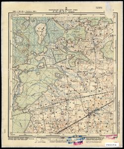
- Description:
- 1926
- Subject:
- Geographic Subject: Pukhnovo, Topical Subject: Soviet Union, and Topical Subject: Maps
- Publisher:
- Управление военных топографов РККА
- Language:
- Russian
- Identifier:
- VAC9619-001188
- Genre:
- Military Maps and Topographic Maps
- Geographic Location:
- Coordinates: 55.8333, 31, 56, 31.25
- Related URL:
- Download GeoTIFF: https://drive.google.com/open?id=1NABJEth3rjI2iCLt9qSEOmI3AvkryE_A and Catalog URL: http://iucat.iu.edu/catalog/5020131
- Abstract:
- Modern area represented: Pukhnovo, Pskov oblast, Russia
- Call Number:
- GM G7000 S50 .S68 N-36-3-A
- Caption:
- Не подлежит оглашению
- City:
- Пухново (Pukhnovo)
- Copyright Holder:
- No Copyright - United States
- Country:
- СССР (USSR)
- State/Province:
- Западная область (Western oblast) and РСФСР (RSFSR)
- Physical Description:
- Scale: 1:50,000
- Persistent URL:
- http://purl.dlib.indiana.edu/iudl/images/VAC9619/VAC9619-001188
- Provenance:
- M. I. Map Library
-
- Description:
- 1928
- Subject:
- Topical Subject: Maps, Topical Subject: Soviet Union, and Geographic Subject: Мостище (Mostyshche)
- Publisher:
- Управление военных топографов
- Language:
- Russian
- Identifier:
- VAC9619-000944
- Genre:
- Military Maps and Topographic Maps
- Geographic Location:
- Coordinates: 50.6667, 31, 50.8333, 31.25
- Related URL:
- Catalog URL: http://iucat.iu.edu/catalog/5020131 and Download GeoTIFF: https://drive.google.com/open?id=1l6N3jMmap6b0-GJ9z4qCApZcFQhcMD8y
- Abstract:
- Modern area represented: Мостище (Mostyshche), Chernihiv oblast, Ukraine
- Call Number:
- G7000 s50 .S68 sheet M-36-39-C
- Caption:
- Не подлежит оглашению
- City:
- Мостище (Mostishche)
- Copyright Holder:
- No Copyright - United States
- Country:
- СССР (USSR)
- State/Province:
- Украинская ССР (Ukrainian Soviet Socialist Republic)
- Physical Description:
- Scale: 1:50,000
- Persistent URL:
- http://purl.dlib.indiana.edu/iudl/images/VAC9619/VAC9619-000944
- Provenance:
- M. I. Map Library
-
- Description:
- 1929
- Subject:
- Geographic Subject: Ковпита (Kovpyta), Topical Subject: Maps, and Topical Subject: Soviet Union
- Publisher:
- Управление военных топографов
- Language:
- Russian
- Date Created:
- 1934
- Identifier:
- VAC9619-000922
- Genre:
- Topographic Maps and Military Maps
- Geographic Location:
- Coordinates: 51.3333, 30.75, 51.5, 31
- Related URL:
- Download GeoTIFF: https://drive.google.com/open?id=1wwFBx8Ytl_OyaIeA8BqneJwwGcqknvXo and Catalog URL: http://iucat.iu.edu/catalog/5020131
- Abstract:
- Modern area represented: Ковпита (Kovpyta), Chernihiv Oblast, Ukraine
- Call Number:
- G7000 s50 .S68 sheet M-36-14-D
- Caption:
- Не подлежит оглашению
- City:
- Колпыта (Kolpyta)
- Copyright Holder:
- No Copyright - United States
- Country:
- СССР (USSR)
- State/Province:
- Украинская ССР (Ukrainian Soviet Socialist Republic)
- Physical Description:
- Scale: 1:50,000
- Persistent URL:
- http://purl.dlib.indiana.edu/iudl/images/VAC9619/VAC9619-000922
- Provenance:
- M. I. Map Library
-
- Description:
- 1929
- Subject:
- Geographic Subject: Петрушi (Petrushi), Topical Subject: Soviet Union, and Topical Subject: Maps
- Publisher:
- Управление военных топографов
- Language:
- Russian
- Identifier:
- VAC9619-000900
- Genre:
- Topographic Maps and Military Maps
- Geographic Location:
- Coordinates: 51.6667, 30.75, 51.8333, 31
- Related URL:
- Download GeoTIFF: https://drive.google.com/open?id=1YUNfCVqepCOgytX5t8nmx6Q3EY7Lj7tN and Catalog URL: http://iucat.iu.edu/catalog/5020131
- Abstract:
- Modern area represented: Петрушi (Petrushi), Chernihiv Oblast, Ukraine
- Call Number:
- G7000 s50 .S68 sheet M-36-2-D
- Caption:
- Не подлежит оглашению
- City:
- Петруши (Petrushi)
- Copyright Holder:
- No Copyright - United States
- Country:
- СССР (USSR)
- State/Province:
- Украинская ССР (Ukrainian Soviet Socialist Republic)
- Physical Description:
- Scale: 1:50,000
- Persistent URL:
- http://purl.dlib.indiana.edu/iudl/images/VAC9619/VAC9619-000900
- Provenance:
- M. I. Map Library
-
- Subject:
- Geographic Subject: Зарічанка (Zarichanka), Topical Subject: Maps, and Topical Subject: Soviet Union
- Publisher:
- Управление военных топографов
- Language:
- Russian
- Identifier:
- VAC9619-000877
- Genre:
- Military Maps and Topographic Maps
- Geographic Location:
- Coordinates: 48.8333, 26.25, 49, 26.5
- Related URL:
- Catalog URL: http://iucat.iu.edu/catalog/5020131 and Download GeoTIFF: https://drive.google.com/open?id=1q7f4o0zCOzXih9xf9t39PFr-bHTtRI6n
- Abstract:
- Modern area represented: Зарічанка (Zarichanka), Khmelnytskyi Oblast, Ukraine
- Call Number:
- G7000 s50 .S68 sheet M-35-113-B
- Caption:
- Не подлежит оглашению
- City:
- Лянцкорунь (Lanckoruń)
- Copyright Holder:
- No Copyright - United States
- Country:
- СССР (USSR)
- State/Province:
- Винницкая область (Vinnytsia oblast) and Украинская ССР (Ukrainian Soviet Socialist Republic)
- Physical Description:
- Scale: 1:50,000
- Persistent URL:
- http://purl.dlib.indiana.edu/iudl/images/VAC9619/VAC9619-000877
- Provenance:
- M. I. Map Library
-
- Description:
- 1931
- Subject:
- Geographic Subject: Тураў (Turow), Topical Subject: Soviet Union, and Topical Subject: Maps
- Publisher:
- Управление военных топографов
- Language:
- Russian
- Identifier:
- VAC9619-000807
- Genre:
- Military Maps and Topographic Maps
- Geographic Location:
- Coordinates: 52, 27.5, 52.167, 27.75
- Related URL:
- Catalog URL: http://iucat.iu.edu/catalog/5020131 and Download GeoTIFF: https://drive.google.com/open?id=1XSod-am5pw3wlcn9E8g_3g3WtxOdNnyD
- Abstract:
- Modern area represented: Тураў (Turow), Homyel' oblast, Belarus
- Call Number:
- G7000 s50 .s68 sheet N-35-140-C
- Caption:
- Не подлежит оглашению
- City:
- Туров (Turov)
- Copyright Holder:
- No Copyright - United States
- Country:
- Польша (Poland) and СССР (USSR)
- State/Province:
- Белорусская ССР (Byelorussian Soviet Socialist Republic)
- Physical Description:
- Scale: 1:50,000
- Persistent URL:
- http://purl.dlib.indiana.edu/iudl/images/VAC9619/VAC9619-000807
- Provenance:
- M. I. Map Library
-
- Description:
- 1936
- Subject:
- Topical Subject: Soviet Union, Geographic Subject: Малыя Гарадзяцічы (Malyya Haradzyatsichy), and Topical Subject: Maps
- Publisher:
- Управление военных топографов РККА
- Language:
- Russian
- Identifier:
- VAC9619-000775
- Genre:
- Topographic Maps and Military Maps
- Geographic Location:
- Coordinates: 52.5, 28.25, 52.667, 28.5
- Related URL:
- Download GeoTIFF: https://drive.google.com/open?id=1h-B6iLq6NlPmjMe9aQVJcksW4YQWeSM6 and Catalog URL: http://iucat.iu.edu/catalog/5020131
- Abstract:
- Modern area represented: Малыя Гарадзяцічы (Malyya Haradzyatsichy), Minsk oblast, Belarus
- Call Number:
- G7000 s50 .s68 sheet N-35-129-B
- Caption:
- Не подлежит оглашению
- City:
- Малые Городятичи (Malye Gorodyatichi)
- Copyright Holder:
- No Copyright - United States
- Country:
- СССР (USSR)
- State/Province:
- Белорусская ССР (Byelorussian Soviet Socialist Republic)
- Physical Description:
- Scale: 1:50,000
- Persistent URL:
- http://purl.dlib.indiana.edu/iudl/images/VAC9619/VAC9619-000775
- Provenance:
- M. I. Map Library
-
- Description:
- 1936
- Subject:
- Topical Subject: Maps, Topical Subject: Soviet Union, and Geographic Subject: Нежын (Nyezhyn)
- Publisher:
- Управление военных топографов РККА
- Language:
- Russian
- Identifier:
- VAC9619-000773
- Genre:
- Topographic Maps and Military Maps
- Geographic Location:
- Coordinates: 52.5, 28.0, 52.66667, 28.25
- Related URL:
- Download GeoTIFF: https://drive.google.com/open?id=1Y_YwQY7alU_iDbJO2_hiDRMfrujMl4m0 and Catalog URL: http://iucat.iu.edu/catalog/5020131
- Abstract:
- Modern area represented: Нежын (Nyezhyn), Minsk oblast, Belarus
- Call Number:
- G7000 s50 .s68 sheet N-35-129-A
- Caption:
- Не подлежит оглашению
- City:
- Нижин (Nizhin)
- Copyright Holder:
- No Copyright - United States
- Country:
- СССР (USSR)
- State/Province:
- Белорусская ССР (Byelorussian Soviet Socialist Republic)
- Physical Description:
- Scale: 1:50,000
- Persistent URL:
- http://purl.dlib.indiana.edu/iudl/images/VAC9619/VAC9619-000773
- Provenance:
- M. I. Map Library
-
- Description:
- 1931
- Subject:
- Topical Subject: Maps, Geographic Subject: Красное Озеро (Krasnoye Ozero), and Topical Subject: Soviet Union
- Publisher:
- Управление военных топографов
- Language:
- Russian
- Identifier:
- VAC9619-000769
- Genre:
- Topographic Maps and Military Maps
- Geographic Location:
- Coordinates: 52.333, 27.75, 52.5, 28
- Related URL:
- Download GeoTIFF: https://drive.google.com/open?id=1u43aA5AchbHJAxX5YShOGtjA4Bc1Kchk and Catalog URL: http://iucat.iu.edu/catalog/5020131
- Abstract:
- Modern area represented: Красное Озеро (Krasnoye Ozero), Minsk oblast, Belarus
- Call Number:
- G7000 s50 .s68 sheet N-35-128-D
- Caption:
- Не подлежит оглашению
- City:
- Червоно Озеро (Chervono Ozero)
- Copyright Holder:
- No Copyright - United States
- Country:
- СССР (USSR)
- State/Province:
- Белорусская ССР (Byelorussian Soviet Socialist Republic)
- Physical Description:
- Scale: 1:50,000
- Persistent URL:
- http://purl.dlib.indiana.edu/iudl/images/VAC9619/VAC9619-000769
- Provenance:
- M. I. Map Library
-
- Description:
- 1936
- Subject:
- Topical Subject: Maps, Topical Subject: Soviet Union, and Geographic Subject: Сосны (Sosny)
- Publisher:
- Управление военных топографов РККА
- Language:
- Russian
- Identifier:
- VAC9619-000763
- Genre:
- Military Maps and Topographic Maps
- Geographic Location:
- Coordinates: 52.5, 27.75, 52.667, 28
- Related URL:
- Download GeoTIFF: https://drive.google.com/open?id=18Jdevul3YJXffildfZj5OED269v2htyW and Catalog URL: http://iucat.iu.edu/catalog/5020131
- Abstract:
- Modern area represented: Сосны (Sosny), Minsk oblast, Belarus
- Call Number:
- G7000 s50 .s68 sheet N-35-128-B
- Caption:
- Не подлежит оглашению
- City:
- Совхоз Сосны (Sovkhoz Sosny)
- Copyright Holder:
- No Copyright - United States
- Country:
- СССР (USSR)
- State/Province:
- Белорусская ССР (Byelorussian Soviet Socialist Republic)
- Physical Description:
- Scale: 1:50,000
- Persistent URL:
- http://purl.dlib.indiana.edu/iudl/images/VAC9619/VAC9619-000763
- Provenance:
- M. I. Map Library
-
- Description:
- 1916
- Subject:
- Geographic Subject: Морач (Morach), Topical Subject: Maps, and Topical Subject: Soviet Union
- Publisher:
- Управление военных топографов РККА
- Language:
- Russian
- Date Created:
- 1936
- Identifier:
- VAC9619-000761
- Genre:
- Topographic Maps and Military Maps
- Geographic Location:
- Coordinates: 52.5, 27.5, 52.667, 27.75
- Related URL:
- Catalog URL: http://iucat.iu.edu/catalog/5020131 and Download GeoTIFF: https://drive.google.com/open?id=1LAByuRyxfjwxyNO78bXbh7EmFF3pEsxW
- Abstract:
- Modern area represented: Морач (Morach), Minsk oblast, Belarus
- Call Number:
- G7000 s50 .s68 sheet N-35-128-A
- Caption:
- Не подлежит оглашению
- City:
- Морочь (Moroch')
- Copyright Holder:
- No Copyright - United States
- Country:
- СССР (USSR) and Польша (Poland)
- State/Province:
- Белорусская ССР (Byelorussian Soviet Socialist Republic)
- Physical Description:
- Scale: 1:50,000
- Persistent URL:
- http://purl.dlib.indiana.edu/iudl/images/VAC9619/VAC9619-000761
- Provenance:
- M. I. Map Library
-
- Description:
- 1911
- Subject:
- Geographic Subject: Гаўрыльчыцы (Hawryl’chytsy), Topical Subject: Maps, and Topical Subject: Soviet Union
- Publisher:
- Управление военных топографов РККА
- Language:
- Russian
- Identifier:
- VAC9619-000754
- Genre:
- Topographic Maps and Military Maps
- Geographic Location:
- Coordinates: 52.5, 27, 52.667, 27.25
- Related URL:
- Catalog URL: http://iucat.iu.edu/catalog/5020131 and Download GeoTIFF: https://drive.google.com/open?id=1yduZIBiYEG42s3l66_1alZ69g-fVND9Z
- Abstract:
- Modern area represented: Гаўрыльчыцы (Hawryl’chytsy), Minsk oblast, Belarus
- Call Number:
- G7000 s50 .s68 sheet N-35-127-A
- Caption:
- Не подлежит оглашению
- City:
- Гаврыльчицэ (Gavryl’chitse)
- Copyright Holder:
- No Copyright - United States
- Country:
- Польша (Poland) and СССР (USSR)
- State/Province:
- Белорусская ССР (Byelorussian Soviet Socialist Republic)
- Physical Description:
- Scale: 1:50,000
- Persistent URL:
- http://purl.dlib.indiana.edu/iudl/images/VAC9619/VAC9619-000754
- Provenance:
- M. I. Map Library
-
- Subject:
- Topical Subject: Soviet Union, Geographic Subject: Капацэвічы (Kapatsevichy), and Topical Subject: Maps
- Publisher:
- Управление военных топографов РККА
- Language:
- Russian
- Identifier:
- VAC9619-000755
- Genre:
- Military Maps and Topographic Maps
- Geographic Location:
- Coordinates: 52.5, 27.25, 52.667, 27.5
- Related URL:
- Download GeoTIFF: https://drive.google.com/open?id=1vmTO5aWsUWP6Bw2II53yvERqOdkrO73P and Catalog URL: http://iucat.iu.edu/catalog/5020131
- Abstract:
- Modern area represented: Капацэвічы (Kapatsevichy), Minsk oblast, Belarus
- Call Number:
- G7000 s50 .s68 sheet N-35-127-B
- Caption:
- Не подлежит оглашению
- City:
- Копацевичи (Kopatsevichi)
- Copyright Holder:
- No Copyright - United States
- Country:
- Польша (Poland) and СССР (USSR)
- State/Province:
- Белорусская ССР (Byelorussian Soviet Socialist Republic)
- Physical Description:
- Scale: 1:50,000
- Persistent URL:
- http://purl.dlib.indiana.edu/iudl/images/VAC9619/VAC9619-000755
- Provenance:
- M. I. Map Library
-
- Description:
- 1936
- Subject:
- Geographic Subject: Здудзічы (Zdudzіchy), Topical Subject: Maps, and Topical Subject: Soviet Union
- Publisher:
- Управление военных топографов
- Language:
- Russian
- Identifier:
- VAC9619-000742
- Genre:
- Topographic Maps and Military Maps
- Geographic Location:
- Coordinates: 52.667, 29.5, 52.833, 29.75
- Related URL:
- Download GeoTIFF: https://drive.google.com/open?id=1ckPNDr9jhSKuuZwyqVMqdZGpu7FaOWGj and Catalog URL: http://iucat.iu.edu/catalog/5020131
- Abstract:
- Modern area represented: Здудзічы (Zdudzіchy), Homyel' oblast, Belarus
- Call Number:
- G7000 s50 .s68 sheet N-35-120-C
- Caption:
- Не подлежит оглашению
- City:
- Здудичи (Zdudichi)
- Copyright Holder:
- No Copyright - United States
- Country:
- СССР (USSR)
- State/Province:
- Белорусская ССР (Byelorussian Soviet Socialist Republic)
- Physical Description:
- Scale: 1:50,000
- Persistent URL:
- http://purl.dlib.indiana.edu/iudl/images/VAC9619/VAC9619-000742
- Provenance:
- M. I. Map Library
-
- Description:
- 1936
- Subject:
- Topical Subject: Soviet Union, Geographic Subject: Шчадрын (Shchadryn), and Topical Subject: Maps
- Publisher:
- Управление военных топографов РККА
- Language:
- Russian
- Identifier:
- VAC9619-000739
- Genre:
- Military Maps and Topographic Maps
- Geographic Location:
- Coordinates: 52.833, 29.5, 53, 29.75
- Related URL:
- Catalog URL: http://iucat.iu.edu/catalog/5020131 and Download GeoTIFF: https://drive.google.com/open?id=1_lAQgddufvK-3WVaihdQVOfKo9mZX4Hq
- Abstract:
- Modern area represented: Шчадрын (Shchadryn), Homyel' oblast, Belarus
- Call Number:
- G7000 s50 .s68 sheet N-35-120-A
- Caption:
- Не подлежит оглашению
- City:
- Щедрин (Shchedrin)
- Copyright Holder:
- No Copyright - United States
- Country:
- СССР (USSR)
- State/Province:
- Белорусская ССР (Byelorussian Soviet Socialist Republic)
- Physical Description:
- Scale: 1:50,000
- Persistent URL:
- http://purl.dlib.indiana.edu/iudl/images/VAC9619/VAC9619-000739
- Provenance:
- M. I. Map Library
-
- Description:
- 1936
- Subject:
- Topical Subject: Maps, Geographic Subject: Парычы (Parychy), and Topical Subject: Soviet Union
- Publisher:
- Управление военных топографов РККА
- Language:
- Russian
- Identifier:
- VAC9619-000737
- Genre:
- Military Maps and Topographic Maps
- Geographic Location:
- Coordinates: 52.667, 29.25, 52.833, 29.5
- Related URL:
- Download GeoTIFF: https://drive.google.com/open?id=1vxmg6glxl2S-32cUsBA93JAY39-zvxMN and Catalog URL: http://iucat.iu.edu/catalog/5020131
- Abstract:
- Modern area represented: Парычы (Parychy), Homyel' oblast, Belarus
- Call Number:
- G7000 s50 .s68 sheet N-35-119-D
- Caption:
- Не подлежит оглашению
- City:
- Паричи (Parichi)
- Copyright Holder:
- No Copyright - United States
- Country:
- СССР (USSR)
- State/Province:
- Белорусская ССР (Byelorussian Soviet Socialist Republic)
- Physical Description:
- Scale: 1:50,000
- Persistent URL:
- http://purl.dlib.indiana.edu/iudl/images/VAC9619/VAC9619-000737
- Provenance:
- M. I. Map Library
-
- Description:
- 1936
- Subject:
- Topical Subject: Maps, Geographic Subject: Дулебы (Dulyeby), and Topical Subject: Soviet Union
- Publisher:
- Управление военных топографов РККА
- Language:
- Russian
- Identifier:
- VAC9619-000636
- Genre:
- Topographic Maps and Military Maps
- Geographic Location:
- Coordinates: 53.667, 29.25, 53.833, 29.5
- Related URL:
- Catalog URL: http://iucat.iu.edu/catalog/5020131 and Download GeoTIFF: https://drive.google.com/open?id=17Yna8Xa2r5w5zMXsvt1-poycGDnr0VXr
- Abstract:
- Modern area represented: Дулебы (Dulyeby), Minsk Oblast, Belarus
- Call Number:
- G7000 s50 .S68 sheet N-35-83-D
- Caption:
- Не подлежит оглашению
- City:
- Дулебо (Dulebo)
- Copyright Holder:
- No Copyright - United States
- Country:
- СССР (USSR)
- State/Province:
- Белорусская ССР (Byelorussian Soviet Socialist Republic)
- Physical Description:
- Scale: 1:50,000
- Persistent URL:
- http://purl.dlib.indiana.edu/iudl/images/VAC9619/VAC9619-000636
- Provenance:
- M. I. Map Library
