
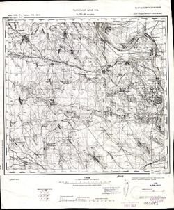
Search Constraints
You searched for:
Subject
Topical Subject: Maps
Remove constraint Subject: Topical Subject: Maps
« Previous |
1 - 100 of 4,129
|
Next »
Search Results
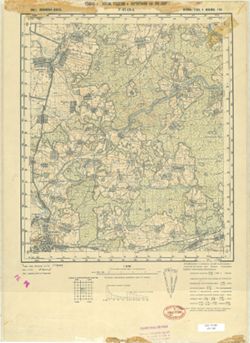
-
- Description:
- 1938
- Subject:
- Topical Subject: Soviet Union, Topical Subject: Maps, and Geographic Subject: Gorshkovo
- Publisher:
- Главное Управление Геодезии и Картографии при СНК СССР
- Language:
- Russian
- Date Created:
- 1941
- Identifier:
- VAC9619-001600
- Genre:
- Military Maps and Topographic Maps
- Geographic Location:
- Coordinates: 54.3333, 37.75, 54.5, 38
- Related URL:
- Download GeoTIFF: https://drive.google.com/open?id=1n5OJOuYUDbObh4psLn6H0cDRB7jPil10 and Catalog URL: http://iucat.iu.edu/catalog/5020131
- Abstract:
- Modern area represented: Gorshkovo, Tula oblast, Russia
- Call Number:
- G7000 s50 .S68 sheet N-37-52-Г
- City:
- Горшково (Gorshkovo)
- Copyright Holder:
- No Copyright - United States
- Country:
- СССР (USSR)
- State/Province:
- РСФСР (RSFSR) and Тульская область (Tula oblast)
- Physical Description:
- Scale: 1:50,000
- Persistent URL:
- http://purl.dlib.indiana.edu/iudl/images/VAC9619/VAC9619-001600
- Provenance:
- DMA Topographic Center, Army Map Service Library, OMAHA, Library of Congress Geography & Map Division
-
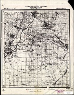
- Description:
- 1853
- Subject:
- Geographic Subject: Laptevo, Topical Subject: Soviet Union, and Topical Subject: Maps
- Publisher:
- Управление военных топографов
- Language:
- Russian
- Date Created:
- 1930
- Identifier:
- VAC9619-001599
- Genre:
- Topographic Maps and Military Maps
- Geographic Location:
- Coordinates: 54.333, 37.573, 54.5, 37.823
- Related URL:
- Catalog URL: http://iucat.iu.edu/catalog/5020131 and Download GeoTIFF: https://drive.google.com/file/d/1aGuqwqLIQb2dh7zU2_a7HtzP9CLQ1XqP/view?usp=sharing
- Abstract:
- Modern area represented: Laptevo, Tula oblast, Russia
- Call Number:
- G7000 s50 .S68 sheet N-37-52-В/Г
- City:
- Ст. Лаптево (Laptevo)
- Copyright Holder:
- No Copyright - United States
- Country:
- СССР (USSR)
- State/Province:
- Московская область (Moscow oblast) and РСФСР (RSFSR)
- Physical Description:
- Scale: 1:50,000
- Persistent URL:
- http://purl.dlib.indiana.edu/iudl/images/VAC9619/VAC9619-001599
- Provenance:
- Army Map Service Library, Library of Congress Geography & Map Division, OMAHA
-
- Description:
- 1938
- Subject:
- Topical Subject: Maps, Geographic Subject: Laptevo, and Topical Subject: Soviet Union
- Publisher:
- Главное Управление Геодезии и Картографии при СНК СССР
- Language:
- Russian
- Date Created:
- 1941
- Identifier:
- VAC9619-001598
- Genre:
- Military Maps and Topographic Maps
- Geographic Location:
- Coordinates: 54.3333, 37.5, 54.5, 37.75
- Related URL:
- Download GeoTIFF: https://drive.google.com/open?id=1jVqSWj3avGDHX-ZeBo8XOwnk6HPHPUR3 and Catalog URL: http://iucat.iu.edu/catalog/5020131
- Abstract:
- Moder area represented: Laptevo, Tula oblast, Russia
- Call Number:
- G7000 s50 .S68 sheet N-37-52-B
- City:
- Лаптево (Laptevo)
- Copyright Holder:
- No Copyright - United States
- Country:
- СССР (USSR)
- State/Province:
- Тульская область (Tula oblast) and РСФСР (RSFSR)
- Physical Description:
- Scale: 1:50,000
- Persistent URL:
- http://purl.dlib.indiana.edu/iudl/images/VAC9619/VAC9619-001598
- Provenance:
- DMA Topographic Center, Army Map Service Library, OMAHA, Library of Congress Geography & Map Division
-
- Description:
- 1938
- Subject:
- Topical Subject: Maps, Geographic Subject: Mokraya Kor, and Topical Subject: Soviet Union
- Publisher:
- Главное Управление Геодезии и Картографии при СНК СССР
- Language:
- Russian
- Date Created:
- 1941
- Identifier:
- VAC9619-001597
- Genre:
- Military Maps and Topographic Maps
- Geographic Location:
- Coordinates: 54.5, 37.75, 54.6667, 38
- Related URL:
- Download GeoTIFF: https://drive.google.com/open?id=1gffQELAjTu3MBlbTHyYP8PMSKwWWqeE2 and Catalog URL: http://iucat.iu.edu/catalog/5020131
- Abstract:
- Modern area represented: Mokraya Kor, Tula oblast, Russia
- Call Number:
- G7000 s50 .S68 sheet N-37-52-B
- City:
- Мокрая Корь (Mokraya Kor)
- Copyright Holder:
- No Copyright - United States
- Country:
- СССР (USSR)
- State/Province:
- Тульская область (Tula oblast) and РСФСР (RSFSR)
- Physical Description:
- Scale: 1:50,000
- Persistent URL:
- http://purl.dlib.indiana.edu/iudl/images/VAC9619/VAC9619-001597
- Provenance:
- DMA Topographic Center, Army Map Service Library, OMAHA, Library of Congress Geography & Map Division
-
- Description:
- 1938
- Subject:
- Geographic Subject: Nikiforovo, Topical Subject: Maps, and Topical Subject: Soviet Union
- Publisher:
- Главное Управление Геодезии и Картографии при СНК СССР
- Language:
- Russian
- Date Created:
- 1941
- Identifier:
- VAC9619-001596
- Genre:
- Topographic Maps and Military Maps
- Geographic Location:
- Coordinates: 54.833, 37.5, 55, 37.75
- Related URL:
- Catalog URL: http://iucat.iu.edu/catalog/5020131 and Download GeoTIFF: https://drive.google.com/open?id=1El5NA8PIkjw7gec-UlLvip8MP0uFlYEF
- Abstract:
- Modern area represented: Nikiforovo, Moscow oblast, Russia
- Call Number:
- G7000 s50 .S68 sheet N-37-40-A
- City:
- Никифорово (Nikiforovo)
- Copyright Holder:
- No Copyright - United States
- Country:
- СССР (USSR)
- State/Province:
- РСФСР (RSFSR), Московская область (Moscow oblast), and Тульская область (Tula oblast)
- Physical Description:
- Scale: 1:50,000
- Persistent URL:
- http://purl.dlib.indiana.edu/iudl/images/VAC9619/VAC9619-001596
- Provenance:
- DMA Topographic Center, Army Map Service Library, OMAHA, Library of Congress Geography & Map Division
-
- Description:
- 1939
- Subject:
- Topical Subject: Soviet Union, Geographic Subject: Novoye Titovo, and Topical Subject: Maps
- Publisher:
- Главное Управление Геодезии и Картографии при СНК СССР
- Language:
- Russian
- Date Created:
- 1941
- Identifier:
- VAC9619-001595
- Genre:
- Topographic Maps and Military Maps
- Geographic Location:
- Coordinates: 55.5, 39, 55.6667, 39.25
- Related URL:
- Catalog URL: http://iucat.iu.edu/catalog/5020131 and Download GeoTIFF: https://drive.google.com/open?id=15wtPDAMzRpWlDqIsKsp-80h3KG7fUqbB
- Abstract:
- Modern area represented: Novoye Titovo, Moscow oblast, Russia
- Call Number:
- G7000 s50 .S68 sheet N-37-19-A
- Copyright Holder:
- No Copyright - United States
- Country:
- СССР (USSR)
- State/Province:
- Московская область (Moscow oblast) and РСФСР (RSFSR)
- Physical Description:
- Scale: 1:50,000
- Persistent URL:
- http://purl.dlib.indiana.edu/iudl/images/VAC9619/VAC9619-001595
- Provenance:
- Army Map Service Library, Library of Congress Geography & Map Division, OMAHA
-
- Description:
- 1926
- Subject:
- Topical Subject: Maps, Geographic Subject: Ilyinsky Pogost, and Topical Subject: Soviet Union
- Publisher:
- Главный Геодезический Комитет
- Language:
- Russian
- Identifier:
- VAC9619-001594
- Genre:
- Military Maps and Topographic Maps
- Geographic Location:
- Coordinates: 55.3333, 38.75, 55.5, 39
- Related URL:
- Download GeoTIFF: https://drive.google.com/open?id=1UmQ-GGS9hBMKjr1ZyiAC9Gg6-BTnRgIE and Catalog URL: http://iucat.iu.edu/catalog/5020131
- Abstract:
- Modern area represented: Ilyinsky Pogost, Moscow oblast, Russia
- Call Number:
- G7000 s50 .S68 sheet N-37-18-Г
- City:
- Ильинский Погост (Ilinskiy Pogost)
- Copyright Holder:
- No Copyright - United States
- Country:
- СССР (USSR)
- State/Province:
- РСФСР (RSFSR) and Московская область (Moscow oblast)
- Physical Description:
- Scale: 1:50,000
- Persistent URL:
- http://purl.dlib.indiana.edu/iudl/images/VAC9619/VAC9619-001594
- Provenance:
- Army Map Service Library, Library of Congress Geography & Map Division, OMAHA
-
- Description:
- 1927
- Subject:
- Geographic Subject: Kurovskoye, Topical Subject: Soviet Union, and Topical Subject: Maps
- Publisher:
- Главный Геодезический Комитет
- Language:
- Russian
- Identifier:
- VAC9619-001592
- Genre:
- Topographic Maps and Military Maps
- Geographic Location:
- Coordinates: 55.5, 38.75, 55.6667, 39
- Related URL:
- Download GeoTIFF: https://drive.google.com/open?id=1PCPLpNhalxc-K3di2FF8ZgGX5bcUdweA and Catalog URL: http://iucat.iu.edu/catalog/5020131
- Abstract:
- Modern area represented: Kurovskoye, Moscow oblast, Russia
- Call Number:
- G7000 s50 .S68 sheet N-37-18-Б
- City:
- Куровская (Kurovskaya)
- Copyright Holder:
- No Copyright - United States
- Country:
- СССР (USSR)
- State/Province:
- Московская область (Moscow oblast) and РСФСР (RSFSR)
- Physical Description:
- Scale: 1:50,000
- Persistent URL:
- http://purl.dlib.indiana.edu/iudl/images/VAC9619/VAC9619-001592
- Provenance:
- DMA Topographic Center, Army Map Service Library, OMAHA, Library of Congress Geography & Map Division
-
- Description:
- 1926
- Subject:
- Topical Subject: Soviet Union, Topical Subject: Maps, and Geographic Subject: Konobeyevo
- Publisher:
- Главный Геодезический Комитет
- Language:
- Russian
- Identifier:
- VAC9619-001593
- Genre:
- Topographic Maps and Military Maps
- Geographic Location:
- Coordinates: 55.3333, 38.5, 55.5, 38.75
- Related URL:
- Catalog URL: http://iucat.iu.edu/catalog/5020131 and Download GeoTIFF: https://drive.google.com/open?id=1n_4NvNZ74yltpHy3SigmaZbvsD15D76K
- Abstract:
- Modern area represented: Konobeyevo, Moscow oblast, Russia
- Call Number:
- G7000 s50 .S68 sheet N-37-18-B
- City:
- Конобеево (Konobeyevo)
- Copyright Holder:
- No Copyright - United States
- Country:
- СССР (USSR)
- State/Province:
- Московская область (Moscow oblast) and РСФСР (RSFSR)
- Physical Description:
- Scale: 1:50,000
- Persistent URL:
- http://purl.dlib.indiana.edu/iudl/images/VAC9619/VAC9619-001593
- Provenance:
- DMA Topographic Center, Army Map Service Library, Library of Congress Geography & Map Division
-
- Description:
- 1883
- Subject:
- Geographic Subject: Târgu Ocna, Topical Subject: Soviet Union, and Topical Subject: Maps
- Publisher:
- Генеральный штаб РККА
- Language:
- Russian
- Date Created:
- 1901
- Identifier:
- VAC9619-001591
- Genre:
- Topographic Maps and Military Maps
- Geographic Location:
- Coordinates: 46, 26.5, 46.3333, 27
- Related URL:
- Catalog URL: https://iucat.iu.edu/catalog/5020129 and Download GeoTIFF: https://drive.google.com/open?id=10x2oiAscdChrKJVEN93a3hEPHjpl_70K
- Abstract:
- Modern area represented: Târgu Ocna, Bacău county, Romania
- Call Number:
- G7000 s100 .S7 sheet L-35-66
- City:
- Тыргул Окна (Târgu Ocna)
- Copyright Holder:
- No Copyright - United States
- Country:
- Румыния (Romania)
- Physical Description:
- Scale: 1:100,000
- Persistent URL:
- http://purl.dlib.indiana.edu/iudl/images/VAC9619/VAC9619-001591
- Provenance:
- CIA Map Library, Atlasblatt
-
- Description:
- 1938
- Subject:
- Geographic Subject: Vereya, Topical Subject: Soviet Union, and Topical Subject: Maps
- Publisher:
- Главное Управление Геодезии и Картографии при СНК СССР
- Language:
- Russian
- Date Created:
- 1941
- Identifier:
- VAC9619-001590
- Genre:
- Topographic Maps and Military Maps
- Geographic Location:
- Coordinates: 55.3333, 36, 55.5, 36.25
- Related URL:
- Download GeoTIFF: https://drive.google.com/open?id=1wBMla9XTlKS1xoCxrPqhKu9J0XdbhkEc and Catalog URL: http://iucat.iu.edu/catalog/5020131
- Abstract:
- Modern area represented: Vereya, Moscow oblast, Russia
- Call Number:
- G7000 s50 .S68 sheet N-37-13-C
- Copyright Holder:
- No Copyright - United States
- Country:
- СССР (USSR)
- State/Province:
- РСФСР (RSFSR) and Московская область (Moscow oblast)
- Physical Description:
- Scale: 1:50,000
- Persistent URL:
- http://purl.dlib.indiana.edu/iudl/images/VAC9619/VAC9619-001590
- Provenance:
- DMA Topographic Center, Army Map Service Library, OMAHA, Library of Congress Geography & Map Division
-
- Description:
- 1938
- Subject:
- Topical Subject: Maps, Topical Subject: Soviet Union, and Geographic Subject: Dorokhovo
- Publisher:
- Главное Управление Геодезии и Картографии при СНК СССР
- Language:
- Russian
- Date Created:
- 1941
- Identifier:
- VAC9619-001589
- Genre:
- Topographic Maps and Military Maps
- Geographic Location:
- Coordinates: 55.5, 36.25, 55.6667, 36.5
- Related URL:
- Catalog URL: http://iucat.iu.edu/catalog/5020131 and Download GeoTIFF: https://drive.google.com/open?id=1ae8VatKg7mKS3Ot_8Hz2EdxDA5_NzAMs
- Abstract:
- Modern area represented: Dorokhovo, Moscow oblast, Russia
- Call Number:
- G7000 s50 .S68 sheet N-37-13-Б
- City:
- Дорохово (Dorokhovo)
- Copyright Holder:
- No Copyright - United States
- Country:
- СССР (USSR)
- State/Province:
- РСФСР (RSFSR) and Московская область (Moscow oblast)
- Physical Description:
- Scale: 1:50,000
- Persistent URL:
- http://purl.dlib.indiana.edu/iudl/images/VAC9619/VAC9619-001589
- Provenance:
- DMA Topographic Center, Army Map Service Library, OMAHA, Library of Congress Geography & Map Division
-
- Description:
- 1938
- Subject:
- Geographic Subject: Mozhaysk, Topical Subject: Soviet Union, and Topical Subject: Maps
- Publisher:
- Главное Управление Геодезии и Картографии при СНК СССР
- Language:
- Russian
- Date Created:
- 1941
- Identifier:
- VAC9619-001588
- Genre:
- Topographic Maps and Military Maps
- Geographic Location:
- Coordinates: 55.5, 36, 55.667, 36.25
- Related URL:
- Catalog URL: http://iucat.iu.edu/catalog/5020131 and Download GeoTIFF: https://drive.google.com/open?id=16nonxp3OQjYiALBOGxIINLA42ZbyRq_9
- Abstract:
- Modern area represented: Mozhaysk, Moscow oblast, Russia
- Call Number:
- G7000 s50 .S68 sheet N-37-13-A
- Copyright Holder:
- No Copyright - United States
- Country:
- СССР (USSR)
- State/Province:
- Московская область (Moscow oblast) and РСФСР (RSFSR)
- Physical Description:
- Scale: 1:50,000
- Persistent URL:
- http://purl.dlib.indiana.edu/iudl/images/VAC9619/VAC9619-001588
- Provenance:
- Library of Congress Geography & Map Division
-
- Description:
- 1922
- Subject:
- Topical Subject: Maps, Topical Subject: Soviet Union, and Geographic Subject: Orekhovo-Zuyevo
- Publisher:
- Геодезический комитет ВСНХ-СССР
- Language:
- Russian
- Date Created:
- 1925
- Identifier:
- VAC9619-001587
- Genre:
- Topographic Maps and Military Maps
- Geographic Location:
- Coordinates: 55.6667, 38.75, 55.8333, 39
- Related URL:
- Catalog URL: http://iucat.iu.edu/catalog/5020131 and Download GeoTIFF: https://drive.google.com/open?id=1YSoC4qULp6BdN-5c-DqfZ7rEYz_wNjk4
- Abstract:
- Modern area represented: Orekhovo-Zuyevo, Moscow oblast, Russia
- Call Number:
- G7000 s50 .S68 sheet N-37-6-Г
- City:
- Орехово-Зуево (Orekhovo-Zuyevo)
- Copyright Holder:
- No Copyright - United States
- Country:
- СССР (USSR)
- State/Province:
- Московская область (Moscow oblast) and РСФСР (RSFSR)
- Physical Description:
- Scale: 1:50,000
- Persistent URL:
- http://purl.dlib.indiana.edu/iudl/images/VAC9619/VAC9619-001587
- Provenance:
- DMA Topographic Center, Army Map Service Library, OMAHA, Library of Congress Geography & Map Division
-
- Description:
- 1922
- Subject:
- Topical Subject: Soviet Union, Topical Subject: Maps, and Geographic Subject: Mytishchi
- Publisher:
- Управление военных топографов
- Language:
- Russian
- Date Created:
- 1929
- Identifier:
- VAC9619-001586
- Genre:
- Military Maps and Topographic Maps
- Geographic Location:
- Coordinates: 55.8667, 37.75, 56, 38
- Related URL:
- Catalog URL: http://iucat.iu.edu/catalog/5020131 and Download GeoTIFF: https://drive.google.com/open?id=1PxyJ7XDtUzjmwpjIlxN45-6k_XMUG50I
- Abstract:
- Modern area represented: Mytishchi, Moscow oblast, Russia
- Call Number:
- G7000 s50 .S68 sheet N-37-4-B
- City:
- Мытищи (Mytishchi)
- Copyright Holder:
- No Copyright - United States
- Country:
- СССР (USSR)
- State/Province:
- РСФСР (RSFSR) and Московская область (Moscow oblast)
- Physical Description:
- Scale: 1:50,000
- Persistent URL:
- http://purl.dlib.indiana.edu/iudl/images/VAC9619/VAC9619-001586
- Provenance:
- CIA Map Library
-
- Description:
- 1922
- Subject:
- Geographic Subject: Pavlovskaya Sloboda, Topical Subject: Soviet Union, and Topical Subject: Maps
- Publisher:
- Главное геодезическое управление
- Language:
- Russian
- Date Created:
- 1925
- Identifier:
- VAC9619-001585
- Genre:
- Topographic Maps and Military Maps
- Geographic Location:
- Coordinates: 55.6667, 37, 55.8667, 37.25
- Related URL:
- Download GeoTIFF: https://drive.google.com/open?id=19y6_pc0fOC1JCk_Asjh7Xv3p2fRVcApN and Catalog URL: http://iucat.iu.edu/catalog/5020131
- Abstract:
- Modern area represented: Pavlovskaya Sloboda, Moscow oblast, Russia
- Call Number:
- G7000 s50 .S68 sheet N-37-3-C
- City:
- Павловская Слобода (Pavlovskaya Sloboda)
- Copyright Holder:
- No Copyright - United States
- Country:
- СССР (USSR)
- State/Province:
- Московская область (Moscow oblast) and РСФСР (RSFSR)
- Physical Description:
- Scale: 1:50,000
- Persistent URL:
- http://purl.dlib.indiana.edu/iudl/images/VAC9619/VAC9619-001585
- Provenance:
- DMA Topographic Center, Army Map Service Library, OMAHA, Library of Congress Geography & Map Division
-

- Description:
- 1922
- Subject:
- Geographic Subject: Voskresensk, Topical Subject: Maps, and Topical Subject: Soviet Union
- Publisher:
- Главное геодезическое управление
- Language:
- Russian
- Date Created:
- 1928
- Identifier:
- VAC9619-001583
- Genre:
- Military Maps and Topographic Maps
- Geographic Location:
- Coordinates: 55.833, 36.5, 56, 37
- Related URL:
- Download GeoTIFF: https://drive.google.com/open?id=1bXX-gCKsqYNk7YsGTvpN1RcM9YGjuXCj and Catalog URL: http://iucat.iu.edu/catalog/5020131
- Abstract:
- Modern area represented: Voskresensk, Moscow oblast, Russia
- Call Number:
- G7000 s50 .S68 sheet N-37-2-A-Б
- City:
- Воскресенск (Voskresensk)
- Copyright Holder:
- No Copyright - United States
- Country:
- СССР (USSR)
- State/Province:
- Московская область (Moscow oblast) and РСФСР (RSFSR)
- Physical Description:
- Scale: 1:50,000
- Persistent URL:
- http://purl.dlib.indiana.edu/iudl/images/VAC9619/VAC9619-001583
- Provenance:
- Library of Congress Geography & Map Division
-
- Description:
- 1938
- Subject:
- Topical Subject: Soviet Union, Topical Subject: Maps, and Geographic Subject: Ruza
- Publisher:
- Главное Управление Геодезии и Картографии при СНК СССР
- Language:
- Russian
- Date Created:
- 1941
- Identifier:
- VAC9619-001582
- Genre:
- Military Maps and Topographic Maps
- Geographic Location:
- Coordinates: 55.6667, 36, 55.8667, 36.25
- Related URL:
- Catalog URL: http://iucat.iu.edu/catalog/5020131 and Download GeoTIFF: https://drive.google.com/open?id=1tuRpf90DTOraQjRedbuLGH5HqzxGMcL0
- Abstract:
- Modern area represented: Ruza, Moscow oblast, Russia
- Call Number:
- G7000 s50 .S68 sheet N-37-1-B
- Copyright Holder:
- No Copyright - United States
- Country:
- СССР (USSR)
- State/Province:
- Московская область (Moscow oblast) and РСФСР (RSFSR)
- Physical Description:
- Scale: 1:50,000
- Persistent URL:
- http://purl.dlib.indiana.edu/iudl/images/VAC9619/VAC9619-001582
- Provenance:
- DMA Topographic Center, Army Map Service Library, Library of Congress Geography & Map Division
-
- Subject:
- Geographic Subject: Dedovsk, Topical Subject: Maps, and Topical Subject: Soviet Union
- Publisher:
- Главное геодезическое управление
- Language:
- Russian
- Identifier:
- VAC9619-001584
- Genre:
- Military Maps and Topographic Maps
- Geographic Location:
- Coordinates: 55.8667, 37, 56, 37.25
- Related URL:
- Download GeoTIFF: https://drive.google.com/open?id=17Vk9RVssm99Q1ZXT6QcsxKfPK7EWyVVA and Catalog URL: http://iucat.iu.edu/catalog/5020131
- Abstract:
- Modern area represented: Dedovsk, Moscow oblast, Russia
- Call Number:
- G7000 s50 .S68 sheet N-37-3-A
- City:
- Дедовский (Dedovskiy)
- Copyright Holder:
- No Copyright - United States
- Country:
- СССР (USSR)
- State/Province:
- Московская область (Moscow oblast) and РСФСР (RSFSR)
- Physical Description:
- Scale: 1:50,000
- Persistent URL:
- http://purl.dlib.indiana.edu/iudl/images/VAC9619/VAC9619-001584
- Provenance:
- M. I. Map Library, Atlasblatt, CIA Map Library
-
- Description:
- 1875
- Subject:
- Geographic Subject: Volintiri, Topical Subject: Soviet Union, and Topical Subject: Maps
- Publisher:
- Генеральный штаб РККА
- Language:
- Russian
- Date Created:
- 1940
- Identifier:
- VAC9619-001581
- Genre:
- Topographic Maps and Military Maps
- Geographic Location:
- Coordinates: 46.3333, 29.5, 46.6667, 30
- Related URL:
- Download GeoTIFF: https://drive.google.com/open?id=1yjBpyWEhLGUL0b_IOaIHHjcBR0P7r7Hi and Catalog URL: https://iucat.iu.edu/catalog/5020129
- Abstract:
- Modern area represented: Volintiri, Ștefan Vodă district, Moldova
- Call Number:
- G7000 s100 .S7 sheet L-35-60
- Caption:
- Не подлежит оглашению
- City:
- Волинтирь (Volintiri)
- Copyright Holder:
- No Copyright - United States
- Country:
- СССР (USSR)
- State/Province:
- Украинская ССР (Ukrainian Soviet Socialist Republic), Одесская область (Odessa oblast), Молдавская АССР (Moldavian Autonomous Soviet Socialist Republic), and...
- Physical Description:
- Scale: 1:100,000
- Persistent URL:
- http://purl.dlib.indiana.edu/iudl/images/VAC9619/VAC9619-001581
- Provenance:
- Library of Congress Geography & Map Division, Atlasblatt, DMA Topographic Center, Army Map Service Library, OMAHA
-
- Description:
- 1930
- Subject:
- Topical Subject: Maps, Topical Subject: Soviet Union, and Geographic Subject: Kamenskiy Khutor
- Publisher:
- Управление военных топографов
- Language:
- Russian
- Identifier:
- VAC9619-001580
- Genre:
- Topographic Maps and Military Maps
- Geographic Location:
- Coordinates: 52, 32.25, 52.1667, 32.5
- Related URL:
- Catalog URL: http://iucat.iu.edu/catalog/5020131 and Download GeoTIFF: https://drive.google.com/open?id=1F40ViE0yDvGViIOC-bOSCTmjsYKUPP0M
- Abstract:
- Modern area represented: Kamenskiy Khutor, Bryansk oblast, Russia
- Call Number:
- G7000 s50 .S68 sheet N-36-137-D
- Caption:
- Не подлежит оглашению
- City:
- Каменский Хутор (Kamenskiy Khutor)
- Copyright Holder:
- No Copyright - United States
- Country:
- СССР (USSR)
- State/Province:
- Западная область (Western oblast), РСФСР (RSFSR), and Украинская ССР (Ukrainian Soviet Socialist Republic)
- Physical Description:
- Scale: 1:50,000
- Persistent URL:
- http://purl.dlib.indiana.edu/iudl/images/VAC9619/VAC9619-001580
- Provenance:
- M. I. Map Library, Atlasblatt
-
- Description:
- 1930
- Subject:
- Topical Subject: Maps, Geographic Subject: Churovichi, and Topical Subject: Soviet Union
- Publisher:
- Управление военных топографов
- Language:
- Russian
- Identifier:
- VAC9619-001577
- Genre:
- Topographic Maps and Military Maps
- Geographic Location:
- Coordinates: 52.1667, 32, 52.3333, 32.25
- Related URL:
- Download GeoTIFF: https://drive.google.com/open?id=1YYiYB76v1eGKgaj7wwzlZh2Pm243OTCJ and Catalog URL: http://iucat.iu.edu/catalog/5020131
- Abstract:
- Modern area represented: Churovichi, Bryansk oblast, Russia
- Call Number:
- G7000 s50 .S68 sheet N-36-137-A
- Caption:
- Не подлежит оглашению
- City:
- Чуровичи (Churovichi)
- Copyright Holder:
- No Copyright - United States
- Country:
- СССР (USSR)
- State/Province:
- Западная область (Western oblast) and РСФСР (RSFSR)
- Physical Description:
- Scale: 1:50,000
- Persistent URL:
- http://purl.dlib.indiana.edu/iudl/images/VAC9619/VAC9619-001577
- Provenance:
- G000-30
-
- Description:
- 1930
- Subject:
- Topical Subject: Maps, Geographic Subject: Novyy Ropsk, and Topical Subject: Soviet Union
- Publisher:
- Управление военных топографов
- Language:
- Russian
- Identifier:
- VAC9619-001578
- Genre:
- Topographic Maps and Military Maps
- Geographic Location:
- Coordinates: 52.1667, 32.25, 52.3333, 32.5
- Related URL:
- Catalog URL: http://iucat.iu.edu/catalog/5020131 and Download GeoTIFF: https://drive.google.com/open?id=13t64kb76EHxk27fhUSp4LHrgQc7MI4jm
- Abstract:
- Modern area represented: Novyy Ropsk, Bryansk oblast, Russia
- Call Number:
- G7000 s50 .S68 sheet N-36-137-Б
- Caption:
- Не подлежит оглашению
- City:
- М. Нов. Ропск (Novyy Ropsk)
- Copyright Holder:
- No Copyright - United States
- Country:
- СССР (USSR)
- State/Province:
- Украинская ССР (Ukrainian Soviet Socialist Republic), РСФСР (RSFSR), and Западная область (Western oblast)
- Physical Description:
- Scale: 1:50,000
- Persistent URL:
- http://purl.dlib.indiana.edu/iudl/images/VAC9619/VAC9619-001578
- Provenance:
- M. I. Map Library, Atlasblatt
-
- Description:
- 1930
- Subject:
- Geographic Subject: Shumilovka, Topical Subject: Maps, and Topical Subject: Soviet Union
- Publisher:
- Управление военных топографов
- Language:
- Russian
- Identifier:
- VAC9619-001579
- Genre:
- Military Maps and Topographic Maps
- Geographic Location:
- Coordinates: 52, 32, 52.1667, 32.25
- Related URL:
- Download GeoTIFF: https://drive.google.com/open?id=1ag3f8ipdIBTu9si4SD7EBCIPQZrD4_po and Catalog URL: http://iucat.iu.edu/catalog/5020131
- Abstract:
- Modern area represented: Shumilovka, Bryansk oblast, Russia
- Call Number:
- G7000 s50 .S68 sheet N-36-137-C
- Caption:
- Не подлежит оглашению
- City:
- Шумиловка (Shumilovka)
- Copyright Holder:
- No Copyright - United States
- Country:
- СССР (USSR)
- State/Province:
- Западная область (Western oblast), РСФСР (RSFSR), and Украинская ССР (Ukrainian Soviet Socialist Republic)
- Physical Description:
- Scale: 1:50,000
- Persistent URL:
- http://purl.dlib.indiana.edu/iudl/images/VAC9619/VAC9619-001579
- Provenance:
- M. I. Map Library, Atlasblatt
-
- Description:
- 1875
- Subject:
- Topical Subject: Soviet Union, Geographic Subject: Leova, and Topical Subject: Maps
- Publisher:
- Генеральный штаб РККА
- Language:
- Russian
- Date Created:
- 1940
- Identifier:
- VAC9619-001576
- Genre:
- Military Maps and Topographic Maps
- Geographic Location:
- Coordinates: 46.3333, 28, 46.6667, 28.5
- Related URL:
- Catalog URL: https://iucat.iu.edu/catalog/5020129 and Download GeoTIFF: https://drive.google.com/open?id=1W71to7iMT8UwC4o77msQuVXKGW3_2Y6g
- Abstract:
- Modern area represented: Leova, Leova district, Moldova
- Call Number:
- G7000 s100 .S7 sheet L-35-57
- City:
- Леово (Leovo)
- Copyright Holder:
- No Copyright - United States
- Country:
- Румыния (Romania)
- State/Province:
- Бессарабия (Bessarabia)
- Physical Description:
- Scale: 1:100,000
- Persistent URL:
- http://purl.dlib.indiana.edu/iudl/images/VAC9619/VAC9619-001576
- Provenance:
- CIA Map Library, Atlasblatt
-
- Description:
- 1929
- Subject:
- Topical Subject: Soviet Union, Geographic Subject: Rogov, and Topical Subject: Maps
- Publisher:
- Военно-топографическое управление
- Language:
- Russian
- Identifier:
- VAC9619-001575
- Genre:
- Topographic Maps and Military Maps
- Geographic Location:
- Coordinates: 52.1667, 31.75, 52.3333, 32
- Related URL:
- Download GeoTIFF: https://drive.google.com/open?id=1dA5Kx5cmuWAiQsNvN42a4-HpPtHvpoN6 and Catalog URL: http://iucat.iu.edu/catalog/5020131
- Abstract:
- Modern area represented: Rogov, Bryansk oblast, Russia
- Call Number:
- G7000 s50 .S68 sheet N-36-136-Б
- Caption:
- Не подлежит оглашению
- City:
- Рогов (Rogov)
- Copyright Holder:
- No Copyright - United States
- Country:
- СССР (USSR)
- State/Province:
- Западная область (Western oblast), РСФСР (RSFSR), and Белорусская ССР (Byelorussian Soviet Socialist Republic)
- Physical Description:
- Scale: 1:50,000
- Persistent URL:
- http://purl.dlib.indiana.edu/iudl/images/VAC9619/VAC9619-001575
- Provenance:
- G000-30
-
- Description:
- 1923
- Subject:
- Topical Subject: Soviet Union, Topical Subject: Maps, and Geographic Subject: Ogorodnya
- Publisher:
- Военно-топографическое управление
- Language:
- Russian
- Identifier:
- VAC9619-001574
- Genre:
- Topographic Maps and Military Maps
- Geographic Location:
- Coordinates: 52.1667, 31.5, 52.3333, 31.75
- Related URL:
- Catalog URL: http://iucat.iu.edu/catalog/5020131 and Download GeoTIFF: https://drive.google.com/open?id=1cw2R9AaZ8ZAzRWXedmEogRMPy8AsxYyA
- Abstract:
- Modern area represented: Ogorodnya, Homyel oblast, Belarus
- Call Number:
- G7000 s50 .S68 sheet N-36-136-A
- Caption:
- Секретно
- City:
- Огородня Гомельская (Ogorodnya-Gomelskaya)
- Copyright Holder:
- No Copyright - United States
- Country:
- СССР (USSR)
- State/Province:
- Западная область (Western oblast), РСФСР (RSFSR), and Белорусская ССР (Byelorussian Soviet Socialist Republic)
- Physical Description:
- Scale: 1:50,000
- Persistent URL:
- http://purl.dlib.indiana.edu/iudl/images/VAC9619/VAC9619-001574
- Provenance:
- G000-30
-
- Description:
- 1929
- Subject:
- Topical Subject: Maps, Geographic Subject: Perepis, and Topical Subject: Soviet Union
- Publisher:
- Военно-топографическое управление
- Language:
- Russian
- Identifier:
- VAC9619-001573
- Genre:
- Military Maps and Topographic Maps
- Geographic Location:
- Coordinates: 52, 31.25, 52.1667, 31.5
- Related URL:
- Download GeoTIFF: https://drive.google.com/open?id=1IRbUSwpZbhhRPZFIBdro4RVzKaabMFon and Catalog URL: http://iucat.iu.edu/catalog/5020131
- Abstract:
- Modern area represented: Perepis, Chernihiv oblast, Ukraine
- Call Number:
- G7000 s50 .S68 sheet N-36-135-Г
- Caption:
- Не подлежит оглашению
- City:
- Перепис (Perepis)
- Copyright Holder:
- No Copyright - United States
- Country:
- СССР (USSR)
- State/Province:
- Белорусская ССР (Byelorussian Soviet Socialist Republic) and Украинская ССР (Ukrainian Soviet Socialist Republic)
- Physical Description:
- Scale: 1:50,000
- Persistent URL:
- http://purl.dlib.indiana.edu/iudl/images/VAC9619/VAC9619-001573
- Provenance:
- G000-30
-

- Description:
- 1889
- Subject:
- Geographic Subject: Sighișoara, Topical Subject: Soviet Union, and Topical Subject: Maps
- Publisher:
- Генеральный штаб РККА
- Language:
- Russian
- Date Created:
- 1940
- Identifier:
- VAC9619-001572
- Genre:
- Topographic Maps and Military Maps
- Geographic Location:
- Coordinates: 46, 24.5, 46.3333, 25
- Related URL:
- Catalog URL: https://iucat.iu.edu/catalog/5020129 and Download GeoTIFF: https://drive.google.com/open?id=1pMjt1y7xJ_zezttERad19SLcAJyJ7ok-
- Abstract:
- Modern area represented: Sighișoara, Mureş county, Romania
- Call Number:
- G7000 s100 .S7 sheet L-35-62
- City:
- Сигишоара (Sighișoara)
- Copyright Holder:
- No Copyright - United States
- Country:
- Венгрия (Hungary) and Румыния (Romania)
- Physical Description:
- Scale: 1:100,000
- Persistent URL:
- http://purl.dlib.indiana.edu/iudl/images/VAC9619/VAC9619-001572
- Provenance:
- Library of Congress Geography & Map Division, Atlasblatt, DMA Topographic Center, Army Map Service Library, OMAHA
-
- Description:
- 1923
- Subject:
- Geographic Subject: Nasovichy, Topical Subject: Maps, and Topical Subject: Soviet Union
- Publisher:
- Управление военных топографов
- Language:
- Russian
- Identifier:
- VAC9619-001571
- Genre:
- Topographic Maps and Military Maps
- Geographic Location:
- Coordinates: 52.1667, 31.25, 52.3333, 31.5
- Related URL:
- Catalog URL: http://iucat.iu.edu/catalog/5020131 and Download GeoTIFF: https://drive.google.com/open?id=10rJAA9fYtU4y4aDEfDF16VBaltwvwW1O
- Abstract:
- Modern area represented: Nasovichy, Homyel Voblasc, Belarus
- Call Number:
- G7000 s50 .S68 sheet N-36-135-Б
- Caption:
- Не подлежит оглашению
- City:
- М. Носовичи (Nasovichy)
- Copyright Holder:
- No Copyright - United States
- Country:
- СССР (USSR)
- State/Province:
- Белорусская ССР (Byelorussian Soviet Socialist Republic)
- Physical Description:
- Scale: 1:50,000
- Persistent URL:
- http://purl.dlib.indiana.edu/iudl/images/VAC9619/VAC9619-001571
- Provenance:
- M. I. Map Library, Atlasblatt
-
- Description:
- 1923
- Subject:
- Topical Subject: Maps, Topical Subject: Soviet Union, and Geographic Subject: Hrabawka
- Publisher:
- Управление военных топографов
- Language:
- Russian
- Date Created:
- 1924
- Identifier:
- VAC9619-001570
- Genre:
- Military Maps and Topographic Maps
- Geographic Location:
- Coordinates: 52.1667, 31, 52.3333, 31.25
- Related URL:
- Download GeoTIFF: https://drive.google.com/open?id=1Eun8Lx2WoA1JEJwWEY2BDAJWOHMosj-a and Catalog URL: http://iucat.iu.edu/catalog/5020131
- Abstract:
- Modern area represented: Hrabawka, Homyel Voblasc, Belarus
- Call Number:
- G7000 s50 .S68 sheet N-36-135-A
- Caption:
- Не подлежит оглашению
- City:
- Грабовка (Hrabawka)
- Copyright Holder:
- No Copyright - United States
- Country:
- СССР (USSR)
- State/Province:
- Белорусская ССР (Byelorussian Soviet Socialist Republic)
- Physical Description:
- Scale: 1:50,000
- Persistent URL:
- http://purl.dlib.indiana.edu/iudl/images/VAC9619/VAC9619-001570
- Provenance:
- G000-30
-
- Description:
- 1929
- Subject:
- Geographic Subject: Sharpilovka, Topical Subject: Maps, and Topical Subject: Soviet Union
- Publisher:
- Военно-топографическое управление
- Language:
- Russian
- Identifier:
- VAC9619-001569
- Genre:
- Topographic Maps and Military Maps
- Geographic Location:
- Coordinates: 52, 30.75, 52.1667, 31
- Related URL:
- Download GeoTIFF: https://drive.google.com/open?id=1xDsLitNkGwrKs-wbr96BSOrPgxbTkpcz and Catalog URL: http://iucat.iu.edu/catalog/5020131
- Abstract:
- Modern area represented: Sharpilovka, Homyel oblast, Belarus
- Call Number:
- G7000 s50 .S68 sheet N-36-134-D
- Caption:
- Не подлежит оглашению
- City:
- Шарпиловка (Sharpilovka)
- Copyright Holder:
- No Copyright - United States
- Country:
- СССР (USSR)
- State/Province:
- Белорусская ССР (Byelorussian Soviet Socialist Republic) and Украинская ССР (Ukrainian Soviet Socialist Republic)
- Physical Description:
- Scale: 1:50,000
- Persistent URL:
- http://purl.dlib.indiana.edu/iudl/images/VAC9619/VAC9619-001569
- Provenance:
- M. I. Map Library, G000-30, GS, RA
-
- Description:
- 1929
- Subject:
- Topical Subject: Soviet Union, Geographic Subject: Kholmyech, and Topical Subject: Maps
- Publisher:
- Военно-топографическое управление
- Language:
- Russian
- Identifier:
- VAC9619-001568
- Genre:
- Military Maps and Topographic Maps
- Geographic Location:
- Coordinates: 52, 30.5, 52.1667, 30.75
- Related URL:
- Download GeoTIFF: https://drive.google.com/open?id=1tTQfvj4yXoC0aIfE6hWv8GZJkE4LQPf0 and Catalog URL: http://iucat.iu.edu/catalog/5020131
- Abstract:
- Modern area represented: Kholmyech, Homyel Voblasc, Belarus
- Call Number:
- G7000 s50 .S68 sheet N-36-134-В
- Caption:
- Секретно
- City:
- М. Холмечь (Kholmyech)
- Copyright Holder:
- No Copyright - United States
- Country:
- СССР (USSR)
- State/Province:
- Белорусская ССР (Byelorussian Soviet Socialist Republic)
- Physical Description:
- Scale: 1:50,000
- Persistent URL:
- http://purl.dlib.indiana.edu/iudl/images/VAC9619/VAC9619-001568
- Provenance:
- M. I. Map Library, GS, RA
-
- Description:
- 1929
- Subject:
- Topical Subject: Maps, Topical Subject: Soviet Union, and Geographic Subject: Chkalovo
- Publisher:
- Управление военных топографов
- Language:
- Russian
- Identifier:
- VAC9619-001567
- Genre:
- Military Maps and Topographic Maps
- Geographic Location:
- Coordinates: 52.1667, 30.75, 52.3333, 31
- Related URL:
- Catalog URL: http://iucat.iu.edu/catalog/5020131 and Download GeoTIFF: https://drive.google.com/open?id=1QPcmGTge2-Re5f6Yt7Jt5V84iTHp4R0d
- Abstract:
- Modern area represented: Chkalovo, Homyel Voblasc, Belarus
- Call Number:
- G7000 s50 .S68 sheet N-36-134-Б
- Caption:
- Не подлежит оглашению
- City:
- Жеребная (Zherebnaya)
- Copyright Holder:
- No Copyright - United States
- Country:
- СССР (USSR)
- State/Province:
- Белорусская ССР (Byelorussian Soviet Socialist Republic)
- Physical Description:
- Scale: 1:50,000
- Persistent URL:
- http://purl.dlib.indiana.edu/iudl/images/VAC9619/VAC9619-001567
- Provenance:
- M. I. Map Library, Atlasblatt
-
- Description:
- 1929
- Subject:
- Topical Subject: Maps, Topical Subject: Soviet Union, and Geographic Subject: Vetkhin
- Publisher:
- Управление военных топографов
- Language:
- Russian
- Identifier:
- VAC9619-001566
- Genre:
- Military Maps and Topographic Maps
- Geographic Location:
- Coordinates: 52.1667, 30.5, 52.3333, 30.75
- Related URL:
- Catalog URL: http://iucat.iu.edu/catalog/5020131 and Download GeoTIFF: https://drive.google.com/open?id=1IdjZjqKeISRFuxWTx1uuBaCVXMXpLmkE
- Abstract:
- Modern area represented: Vetkhin, Homyel Voblasc, Belarus
- Call Number:
- G7000 s50 .S68 sheet N-36-134-A
- Caption:
- Не подлежит оглашению
- Copyright Holder:
- No Copyright - United States
- Country:
- СССР (USSR)
- State/Province:
- Белорусская ССР (Byelorussian Soviet Socialist Republic)
- Physical Description:
- Scale: 1:50,000
- Persistent URL:
- http://purl.dlib.indiana.edu/iudl/images/VAC9619/VAC9619-001566
- Provenance:
- M. I. Map Library, Atlasblatt
-
- Description:
- 1929
- Subject:
- Topical Subject: Soviet Union, Geographic Subject: Novyy Barsuk, and Topical Subject: Maps
- Publisher:
- Управление военных топографов
- Language:
- Russian
- Date Created:
- 1930
- Identifier:
- VAC9619-001565
- Genre:
- Military Maps and Topographic Maps
- Geographic Location:
- Coordinates: 52, 30.25, 52.1667, 30.5
- Related URL:
- Download GeoTIFF: https://drive.google.com/open?id=1xAqaU1gE6Y2IhwXoJ_TpZglXYfUyXzwM and Catalog URL: http://iucat.iu.edu/catalog/5020131
- Abstract:
- Modern area represented: Novyy Barsuk, Homyel Voblasc, Belarus
- Call Number:
- G7000 s50 .S68 sheet N-36-133-Г
- Caption:
- Не подлежит оглашению
- City:
- Нов. Барсук (Novyy Barsuk)
- Copyright Holder:
- No Copyright - United States
- Country:
- СССР (USSR)
- State/Province:
- Белорусская ССР (Byelorussian Soviet Socialist Republic)
- Physical Description:
- Scale: 1:50,000
- Persistent URL:
- http://purl.dlib.indiana.edu/iudl/images/VAC9619/VAC9619-001565
- Provenance:
- M. I. Map Library, G000-30
-
- Description:
- 1929
- Subject:
- Geographic Subject: Bronnoye, Topical Subject: Soviet Union, and Topical Subject: Maps
- Publisher:
- Управление военных топографов
- Language:
- Russian
- Date Created:
- 1934
- Identifier:
- VAC9619-001563
- Genre:
- Topographic Maps and Military Maps
- Geographic Location:
- Coordinates: 52.1667, 30.25, 52.3333, 30.5
- Related URL:
- Download GeoTIFF: https://drive.google.com/open?id=11UlRUXshSkRws4kkl47mEECybC9419Dv and Catalog URL: http://iucat.iu.edu/catalog/5020131
- Abstract:
- Modern area represented: Bronnoye, Homyel Voblasc, Belarus
- Call Number:
- G7000 s50 .S68 sheet N-36-133-Б
- Caption:
- Не подлежит оглашению
- City:
- Бронное (Bronnoye)
- Copyright Holder:
- No Copyright - United States
- Country:
- СССР (USSR)
- State/Province:
- Белорусская ССР (Byelorussian Soviet Socialist Republic)
- Physical Description:
- Scale: 1:50,000
- Persistent URL:
- http://purl.dlib.indiana.edu/iudl/images/VAC9619/VAC9619-001563
- Provenance:
- M. I. Map Library, GS, RA
-
- Description:
- 1930
- Subject:
- Topical Subject: Maps, Topical Subject: Soviet Union, and Geographic Subject: Omelkovshchina
- Publisher:
- Управление военных топографов
- Language:
- Russian
- Date Created:
- 1931
- Identifier:
- VAC9619-001564
- Genre:
- Military Maps and Topographic Maps
- Geographic Location:
- Coordinates: 52, 30, 52.1667, 30.25
- Related URL:
- Catalog URL: http://iucat.iu.edu/catalog/5020131 and Download GeoTIFF: https://drive.google.com/open?id=1kYdLYWjzrU7Qvt27O8aTu7wWl8HKLs5x
- Abstract:
- Modern area represented: Omelkovshchina, Homyel Voblasc, Belarus
- Call Number:
- G7000 s50 .S68 sheet N-36-133-B
- Caption:
- Не подлежит оглашению
- City:
- Омельковщина (Omelkovshchina)
- Copyright Holder:
- No Copyright - United States
- Country:
- СССР (USSR)
- State/Province:
- Белорусская ССР (Byelorussian Soviet Socialist Republic)
- Physical Description:
- Scale: 1:50,000
- Persistent URL:
- http://purl.dlib.indiana.edu/iudl/images/VAC9619/VAC9619-001564
- Provenance:
- M. I. Map Library, GS, RA
-
- Description:
- 1930
- Subject:
- Topical Subject: Maps, Geographic Subject: Korovatichi, and Topical Subject: Soviet Union
- Publisher:
- Управление военных топографов
- Language:
- Russian
- Date Created:
- 1931
- Identifier:
- VAC9619-001562
- Genre:
- Topographic Maps and Military Maps
- Geographic Location:
- Coordinates: 52.1667, 30, 52.3333, 30.25
- Related URL:
- Download GeoTIFF: https://drive.google.com/open?id=1sZKoGMePrOPDI3kUpfaEh7g971pj-_mA and Catalog URL: http://iucat.iu.edu/catalog/5020131
- Abstract:
- Modern area represented: Korovatichi, Homyel Voblasc, Belarus
- Call Number:
- G7000 s50 .S68 sheet N-36-133-A
- Caption:
- Не подлежит оглашению
- City:
- Короватичи (Korovatichi)
- Copyright Holder:
- No Copyright - United States
- Country:
- СССР (USSR)
- State/Province:
- Белорусская ССР (Byelorussian Soviet Socialist Republic)
- Physical Description:
- Scale: 1:50,000
- Persistent URL:
- http://purl.dlib.indiana.edu/iudl/images/VAC9619/VAC9619-001562
- Provenance:
- CIA Map Branch -- Received, FEM Austria
-
- Description:
- 1940
- Subject:
- Geographic Subject: Kokorevka, Topical Subject: Soviet Union, and Topical Subject: Maps
- Publisher:
- Главное Управление Геодезии и Картографии при СНК СССР
- Language:
- Russian
- Date Created:
- 1941
- Identifier:
- VAC9619-001561
- Genre:
- Military Maps and Topographic Maps
- Geographic Location:
- Coordinates: 52.5, 34.25, 52.6667, 34.5
- Related URL:
- Catalog URL: http://iucat.iu.edu/catalog/5020131 and Download GeoTIFF: https://drive.google.com/open?id=1aCIFWOLZoer3DkKzSR6t75p6d6aOZN2J
- Abstract:
- Modern area represented: Kokorevka, Bryansk oblast, Russia
- Call Number:
- G7000 s50 .S68 sheet N-36-129-B
- City:
- Кокоревка (Kokorevka)
- Copyright Holder:
- No Copyright - United States
- Country:
- СССР (USSR)
- State/Province:
- Орловская область (Oryol oblast) and РСФСР (RSFSR)
- Physical Description:
- Scale: 1:50,000
- Persistent URL:
- http://purl.dlib.indiana.edu/iudl/images/VAC9619/VAC9619-001561
- Provenance:
- DMA Topographic Center, Army Map Service Library, OMAHA, Library of Congress Geography & Map Division
-
- Description:
- 1928
- Subject:
- Geographic Subject: Klimovo, Topical Subject: Maps, and Topical Subject: Soviet Union
- Publisher:
- Управление военных топографов
- Language:
- Russian
- Identifier:
- VAC9619-001560
- Genre:
- Topographic Maps and Military Maps
- Geographic Location:
- Coordinates: 52.3333, 32, 52.5, 32.25
- Related URL:
- Download GeoTIFF: https://drive.google.com/open?id=1RrNw6YCrm6c28zRz1e-S_6bXBdsEhT7f and Catalog URL: http://iucat.iu.edu/catalog/5020131
- Abstract:
- Modern area represented: Klimovo, Bryansk oblast, Russia
- Call Number:
- G7000 s50 .S68 sheet N-36-125-B
- Caption:
- Не подлежит оглашению
- City:
- Климов ( Klimov)
- Copyright Holder:
- No Copyright - United States
- Country:
- СССР (USSR)
- State/Province:
- Западная область (Western oblast) and РСФСР (RSFSR)
- Physical Description:
- Scale: 1:50,000
- Persistent URL:
- http://purl.dlib.indiana.edu/iudl/images/VAC9619/VAC9619-001560
- Provenance:
- M. I. Map Library, Atlasblatt, GS, RA
-
- Description:
- 1936
- Subject:
- Topical Subject: Soviet Union, Topical Subject: Maps, and Geographic Subject: Qaradonlu
- Publisher:
- Генеральный штаб РККА
- Language:
- Russian
- Identifier:
- VAC9619-001559
- Genre:
- Military Maps and Topographic Maps
- Geographic Location:
- Coordinates: 39.66667, 48.0, 40.0, 48.5
- Related URL:
- Catalog URL: https://iucat.iu.edu/catalog/5020129 and Download GeoTIFF: https://drive.google.com/open?id=1YkiF1tKuoAu3wohR74kqHDCggG6h4elJ
- Abstract:
- Modern area represented: Qaradonlu, Imishli district, Azerbaijan
- Call Number:
- G7000 s100 .S7 sheet J-39-1
- Caption:
- Не подлежит оглашению
- City:
- Карадонлы (Qaradonlu)
- Copyright Holder:
- No Copyright - United States
- Country:
- Иран (Iran)
- State/Province:
- Азербайджанская ССР (Azerbaijan Soviet Socialist Republic)
- Physical Description:
- Scale: 1:100,000
- Persistent URL:
- http://purl.dlib.indiana.edu/iudl/images/VAC9619/VAC9619-001559
- Provenance:
- DMA Topographic Center, Auswärtiges Amt. Geographischer Dienst, OMAHA, Army Map Service Library, Library of Congress Geography & Map Division
-
- Description:
- 1923
- Subject:
- Geographic Subject: Katashin, Topical Subject: Soviet Union, and Topical Subject: Maps
- Publisher:
- Военно-топографическое управление
- Language:
- Russian
- Identifier:
- VAC9619-001558
- Genre:
- Military Maps and Topographic Maps
- Geographic Location:
- Coordinates: 52.5, 32, 52.6667, 32.25
- Related URL:
- Download GeoTIFF: https://drive.google.com/open?id=1XlBvnUSbmkKKvdFOIoJr7sfr8LMDwdS8 and Catalog URL: http://iucat.iu.edu/catalog/5020131
- Abstract:
- Modern area represented: Katashin, Bryansk oblast, Russia
- Call Number:
- G7000 s50 .S68 sheet N-36-125-A
- Caption:
- Не подлежит оглашению
- City:
- Каташин (Katashin)
- Copyright Holder:
- No Copyright - United States
- Country:
- СССР (USSR)
- State/Province:
- Западная область (Western oblast) and РСФСР (RSFSR)
- Physical Description:
- Scale: 1:50,000
- Persistent URL:
- http://purl.dlib.indiana.edu/iudl/images/VAC9619/VAC9619-001558
- Provenance:
- M. I. Map Library, Atlasblatt, GS, RA
-
- Description:
- 1928
- Subject:
- Topical Subject: Maps, Topical Subject: Soviet Union, and Geographic Subject: Zlynka
- Publisher:
- Военно-топографическое управление
- Language:
- Russian
- Identifier:
- VAC9619-001557
- Genre:
- Military Maps and Topographic Maps
- Geographic Location:
- Coordinates: 52.3333, 31.5, 52.5, 31.75
- Related URL:
- Download GeoTIFF: https://drive.google.com/open?id=16_idUtLHfzb14nWucyDFo6LZMv_m6-s4 and Catalog URL: http://iucat.iu.edu/catalog/5020131
- Abstract:
- Modern area represented: Zlynka, Bryansk oblast, Russia
- Call Number:
- G7000 s50 .S68 sheet N-36-124-В
- Caption:
- Не подлежит оглашению
- City:
- Злынка (Zlynka)
- Copyright Holder:
- No Copyright - United States
- Country:
- СССР (USSR)
- State/Province:
- РСФСР (RSFSR), Белорусская ССР (Byelorussian Soviet Socialist Republic), and Западная область (Western oblast)
- Physical Description:
- Scale: 1:50,000
- Persistent URL:
- http://purl.dlib.indiana.edu/iudl/images/VAC9619/VAC9619-001557
- Provenance:
- M. I. Map Library, Atlasblatt, GS, RA
-
- Description:
- 1923
- Subject:
- Topical Subject: Soviet Union, Geographic Subject: Staryy Vyshkov, and Topical Subject: Maps
- Publisher:
- Военно-топографическое управление
- Language:
- Russian
- Identifier:
- VAC9619-001556
- Genre:
- Topographic Maps and Military Maps
- Geographic Location:
- Coordinates: 52.5, 31.5, 52.6667, 31.75
- Related URL:
- Download GeoTIFF: https://drive.google.com/open?id=11QgvP8bYcegYDk0J7SzB9E83Rq76NIEI and Catalog URL: http://iucat.iu.edu/catalog/5020131
- Abstract:
- Modern area represented: Staryy Vyshkov, Bryansk oblast, Russia
- Call Number:
- G7000 s50 .S68 sheet N-36-124-A
- Caption:
- Секретно
- City:
- Стар. Вышков (Staryy Vyshkov)
- Copyright Holder:
- No Copyright - United States
- Country:
- СССР (USSR)
- State/Province:
- Западная область (Western oblast), Белорусская ССР (Byelorussian Soviet Socialist Republic), and РСФСР (RSFSR)
- Physical Description:
- Scale: 1:50,000
- Persistent URL:
- http://purl.dlib.indiana.edu/iudl/images/VAC9619/VAC9619-001556
- Provenance:
- M. I. Map Library, Atlasblatt, GS, RA
-
- Description:
- 1923
- Subject:
- Topical Subject: Maps, Topical Subject: Soviet Union, and Geographic Subject: Sivinka
- Publisher:
- Управление военных топографов
- Language:
- Russian
- Identifier:
- VAC9619-001555
- Genre:
- Military Maps and Topographic Maps
- Geographic Location:
- Coordinates: 52.5, 31.25, 52.6667, 31.5
- Related URL:
- Download GeoTIFF: https://drive.google.com/open?id=1eCZ0fw33TfBskuVsA-gqvxYJghl8B7HS and Catalog URL: http://iucat.iu.edu/catalog/5020131
- Abstract:
- Modern area represented: Sivinka, Homyel Voblasc, Belarus
- Call Number:
- G7000 s50 .S68 sheet N-36-123-Б
- Caption:
- Не подлежит оглашению
- City:
- Савинка (Savinka)
- Copyright Holder:
- No Copyright - United States
- Country:
- СССР (USSR)
- State/Province:
- Белорусская ССР (Byelorussian Soviet Socialist Republic)
- Physical Description:
- Scale: 1:50,000
- Persistent URL:
- http://purl.dlib.indiana.edu/iudl/images/VAC9619/VAC9619-001555
- Provenance:
- M. I. Map Library, Atlasblatt, GS, RA
-
- Description:
- 1926
- Subject:
- Topical Subject: Soviet Union, Topical Subject: Maps, and Geographic Subject: Barshchowka
- Publisher:
- Военно-топографическое управление
- Language:
- Russian
- Identifier:
- VAC9619-001553
- Genre:
- Topographic Maps and Military Maps
- Geographic Location:
- Coordinates: 52.3333, 30.5, 52.5, 30.75
- Related URL:
- Download GeoTIFF: https://drive.google.com/open?id=1CKjBQIPEdHZFogM-IJu5KmE7sAHsqtt7 and Catalog URL: http://iucat.iu.edu/catalog/5020131
- Abstract:
- Modern area represented: Barshchowka, Homyel oblast, Belarus
- Call Number:
- G7000 s50 .S68 sheet N-36-122-C
- Caption:
- Секретно
- City:
- Борщовка (Barshchowka)
- Copyright Holder:
- No Copyright - United States
- Country:
- СССР (USSR)
- State/Province:
- Белорусская ССР (Byelorussian Soviet Socialist Republic)
- Physical Description:
- Scale: 1:50,000
- Persistent URL:
- http://purl.dlib.indiana.edu/iudl/images/VAC9619/VAC9619-001553
- Provenance:
- Army Map Service Library, Library of Congress Geography & Map Division, OMAHA
-
- Description:
- 1923
- Subject:
- Topical Subject: Soviet Union, Geographic Subject: Vyetka, and Topical Subject: Maps
- Publisher:
- Управление военных топографов
- Language:
- Russian
- Identifier:
- VAC9619-001554
- Genre:
- Topographic Maps and Military Maps
- Geographic Location:
- Coordinates: 52.5, 31, 52.6667, 31.25
- Related URL:
- Download GeoTIFF: https://drive.google.com/open?id=1VDbP9_pF7RIM9BgpD_fxSGsol9nd1wuC and Catalog URL: http://iucat.iu.edu/catalog/5020131
- Abstract:
- Modern area represented: Vyetka, Homyel oblast, Belarus
- Call Number:
- G7000 s50 .S68 sheet N-36-123-A
- Caption:
- Не подлежит оглашению
- City:
- Ветка (Vyetka)
- Copyright Holder:
- No Copyright - United States
- Country:
- СССР (USSR)
- State/Province:
- Белорусская ССР (Byelorussian Soviet Socialist Republic)
- Physical Description:
- Scale: 1:50,000
- Persistent URL:
- http://purl.dlib.indiana.edu/iudl/images/VAC9619/VAC9619-001554
- Provenance:
- CIA Map Branch -- Received
-
- Description:
- 1923
- Subject:
- Topical Subject: Maps, Geographic Subject: Yaromina, and Topical Subject: Soviet Union
- Publisher:
- Управление военных топографов РККА
- Language:
- Russian
- Identifier:
- VAC9619-001552
- Genre:
- Military Maps and Topographic Maps
- Geographic Location:
- Coordinates: 52.5, 30.75, 52.6667, 31
- Related URL:
- Download GeoTIFF: https://drive.google.com/open?id=1EwdH-g3Dx_6LD5AnhZVhdXQHoiUylwrg and Catalog URL: http://iucat.iu.edu/catalog/5020131
- Abstract:
- Modern area represented: Yaromina, Homyel oblast, Belarus
- Call Number:
- G7000 s50 .S68 sheet N-36-122-B
- Caption:
- Не подлежит оглашению
- City:
- Еремино (Yaromina)
- Copyright Holder:
- No Copyright - United States
- Country:
- СССР (USSR)
- State/Province:
- Белорусская ССР (Byelorussian Soviet Socialist Republic)
- Physical Description:
- Scale: 1:50,000
- Persistent URL:
- http://purl.dlib.indiana.edu/iudl/images/VAC9619/VAC9619-001552
- Provenance:
- M. I. Map Library, Atlasblatt
-

- Description:
- 1930
- Subject:
- Topical Subject: Soviet Union, Topical Subject: Maps, and Geographic Subject: Volodarsk
- Publisher:
- Управление военных топографов РККА
- Language:
- Russian
- Date Created:
- 1931
- Identifier:
- VAC9619-001550
- Genre:
- Military Maps and Topographic Maps
- Geographic Location:
- Coordinates: 52.3333, 30, 52.5, 30.25
- Related URL:
- Catalog URL: http://iucat.iu.edu/catalog/5020131 and Download GeoTIFF: https://drive.google.com/open?id=14iHQXU-g8T1RMvt81Kvfrqde3lXKwkh5
- Abstract:
- Modern area represented: Volodarsk, Homyel oblast, Belarus
- Call Number:
- G7000 s50 .S68 sheet N-36-121-C
- Caption:
- Не подлежит оглашению
- City:
- Гавеновичи (Gavenovichi)
- Copyright Holder:
- No Copyright - United States
- Country:
- СССР (USSR)
- State/Province:
- Белорусская ССР (Byelorussian Soviet Socialist Republic)
- Physical Description:
- Scale: 1:50,000
- Persistent URL:
- http://purl.dlib.indiana.edu/iudl/images/VAC9619/VAC9619-001550
- Provenance:
- Army Map Service Library, Library of Congress Geography & Map Division, OMAHA
-
- Description:
- 1926
- Subject:
- Geographic Subject: Rechytsa, Topical Subject: Soviet Union, and Topical Subject: Maps
- Publisher:
- Управление военных топографов
- Language:
- Russian
- Date Created:
- 1934
- Identifier:
- VAC9619-001551
- Genre:
- Topographic Maps and Military Maps
- Geographic Location:
- Coordinates: 52.3333, 30.25, 52.5, 30.5
- Related URL:
- Catalog URL: http://iucat.iu.edu/catalog/5020131 and Download GeoTIFF: https://drive.google.com/open?id=1W3PoDvQej2qE34tAwwmuO7ZWbCQ38cNU
- Abstract:
- Modern area represented: Rechytsa, Homyel oblast, Belarus
- Call Number:
- G7000 s50 .S68 sheet N-36-121-D
- Caption:
- Не подлежит оглашению
- City:
- Речица (Rechytsa)
- Copyright Holder:
- No Copyright - United States
- Country:
- СССР (USSR)
- State/Province:
- Белорусская ССР (Byelorussian Soviet Socialist Republic)
- Physical Description:
- Scale: 1:50,000
- Persistent URL:
- http://purl.dlib.indiana.edu/iudl/images/VAC9619/VAC9619-001551
- Provenance:
- CIA Map Branch -- Received
-
- Description:
- 1875
- Subject:
- Topical Subject: Maps, Topical Subject: Soviet Union, and Geographic Subject: Tighina
- Publisher:
- Генеральный штаб РККА
- Language:
- Russian
- Date Created:
- 1940
- Identifier:
- VAC9619-001549
- Genre:
- Military Maps and Topographic Maps
- Geographic Location:
- Coordinates: 46.6667, 29, 47, 29.5
- Related URL:
- Catalog URL: https://iucat.iu.edu/catalog/5020129 and Download GeoTIFF: https://drive.google.com/open?id=1MZ4PrCBw5im-5F634wMbg7bDcKcTTsDN
- Abstract:
- Modern area represented: Tighina, Bender municipality, Moldova
- Call Number:
- G7000 s100 .S7 sheet L-35-47
- Caption:
- Не подлежит оглашению
- City:
- Бендеры (Bendery)
- Copyright Holder:
- No Copyright - United States
- State/Province:
- Бессарабия (Bessarabia), Украинская ССР (Ukrainian Soviet Socialist Republic), and Молдавская АССР (Moldavian Autonomous Soviet Socialist Republic)
- Physical Description:
- Scale: 1:100,000
- Persistent URL:
- http://purl.dlib.indiana.edu/iudl/images/VAC9619/VAC9619-001549
- Provenance:
- CIA Map Library, Geographisches Institut der Universität Berlin
-

- Description:
- 1936
- Subject:
- Topical Subject: Maps, Topical Subject: Soviet Union, and Geographic Subject: Chebotovichi
- Publisher:
- Управление военных топографов РККА
- Language:
- Russian
- Identifier:
- VAC9619-001548
- Genre:
- Military Maps and Topographic Maps
- Geographic Location:
- Coordinates: 52.5, 30.25, 52.6667, 30.5
- Related URL:
- Download GeoTIFF: https://drive.google.com/open?id=1hEz-hZWO57SmZPvZbEaBzu7WJ1kcE6kz and Catalog URL: http://iucat.iu.edu/catalog/5020131
- Abstract:
- Modern area represented: Chebotovichi, Homyel oblast, Belarus
- Call Number:
- G7000 s50 .S68 sheet N-36-121-B
- Caption:
- Не подлежит оглашению
- City:
- Чеботовичи (Chebotovichi)
- Copyright Holder:
- No Copyright - United States
- Country:
- СССР (USSR)
- State/Province:
- Белорусская ССР (Byelorussian Soviet Socialist Republic)
- Physical Description:
- Scale: 1:50,000
- Persistent URL:
- http://purl.dlib.indiana.edu/iudl/images/VAC9619/VAC9619-001548
- Provenance:
- Army Map Service Library, Library of Congress Geography & Map Division, OMAHA
-

- Description:
- 1926
- Subject:
- Geographic Subject: Gorval, Topical Subject: Maps, and Topical Subject: Soviet Union
- Publisher:
- Управление военных топографов РККА
- Language:
- Russian
- Date Created:
- 1936
- Identifier:
- VAC9619-001547
- Genre:
- Military Maps and Topographic Maps
- Geographic Location:
- Coordinates: 52.5, 30, 52.6667, 30.25
- Related URL:
- Download GeoTIFF: https://drive.google.com/open?id=1SBp1cSyxbsOZzW87Z5z7xzVDLRHTxnom and Catalog URL: http://iucat.iu.edu/catalog/5020131
- Abstract:
- Modern area represented: Gorval, Homyel oblast, Belarus
- Call Number:
- G7000 s50 .S68 sheet N-36-121-A
- Caption:
- Не подлежит оглашению
- City:
- Горваль (Gorval)
- Copyright Holder:
- No Copyright - United States
- Country:
- СССР (USSR)
- State/Province:
- Белорусская ССР (Byelorussian Soviet Socialist Republic)
- Physical Description:
- Scale: 1:50,000
- Persistent URL:
- http://purl.dlib.indiana.edu/iudl/images/VAC9619/VAC9619-001547
- Provenance:
- Army Map Service Library, Library of Congress Geography & Map Division, OMAHA
-
- Description:
- 1930
- Subject:
- Topical Subject: Maps, Geographic Subject: Navlya, and Topical Subject: Soviet Union
- Publisher:
- Генеральный штаб РККА
- Language:
- Russian
- Identifier:
- VAC9619-001546
- Genre:
- Military Maps and Topographic Maps
- Geographic Location:
- Coordinates: 52.6667, 34.25, 52.8667, 34.5
- Related URL:
- Catalog URL: http://iucat.iu.edu/catalog/5020131 and Download GeoTIFF: https://drive.google.com/open?id=1Ft9GtpEPyu9OemJD8QV4vz-9cxhamZtf
- Abstract:
- Modern area represented: Navlya, Bryansk oblast, Russia
- Call Number:
- G7000 s50 .S68 sheet N-36-117-D
- Caption:
- Не подлежит оглашению
- City:
- Навля (Navlya)
- Copyright Holder:
- No Copyright - United States
- Country:
- СССР (USSR)
- State/Province:
- Западная область (Western oblast) and РСФСР (RSFSR)
- Physical Description:
- Scale: 1:50,000
- Persistent URL:
- http://purl.dlib.indiana.edu/iudl/images/VAC9619/VAC9619-001546
- Provenance:
- Army Map Service Library, Library of Congress Geography & Map Division, OMAHA
-
- Description:
- 1930
- Subject:
- Topical Subject: Soviet Union, Geographic Subject: Glinnoye, and Topical Subject: Maps
- Publisher:
- Управление военных топографов
- Language:
- Russian
- Identifier:
- VAC9619-001545
- Genre:
- Topographic Maps and Military Maps
- Geographic Location:
- Coordinates: 52.6667, 34, 52.8667, 34.25
- Related URL:
- Download GeoTIFF: https://drive.google.com/open?id=1uWYhWHvpVp_Nl1t930g9SItH1ud9X63r and Catalog URL: http://iucat.iu.edu/catalog/5020131
- Abstract:
- Modern area represented: Glinnoye, Bryansk oblast, Russia
- Call Number:
- G7000 s50 .S68 sheet N-36-117-C
- Caption:
- Не подлежит оглашению
- City:
- Глинное (Glinnoye)
- Copyright Holder:
- No Copyright - United States
- Country:
- СССР (USSR)
- State/Province:
- Западная область (Western oblast) and РСФСР (RSFSR)
- Physical Description:
- Scale: 1:50,000
- Persistent URL:
- http://purl.dlib.indiana.edu/iudl/images/VAC9619/VAC9619-001545
- Provenance:
- Army Map Service Library, Library of Congress Geography & Map Division, OMAHA
-
- Description:
- 1930
- Subject:
- Topical Subject: Soviet Union, Topical Subject: Maps, and Geographic Subject: Pervomayskoye
- Publisher:
- Генеральный штаб Красной Армии
- Language:
- Russian
- Date Created:
- 1934
- Identifier:
- VAC9619-001544
- Genre:
- Topographic Maps and Military Maps
- Geographic Location:
- Coordinates: 52.8667, 33.5, 53, 33.75
- Related URL:
- Download GeoTIFF: https://drive.google.com/open?id=1jvWuFAQ4n_nl6IkEGFq_87wHlKtMxVO5 and Catalog URL: http://iucat.iu.edu/catalog/5020131
- Abstract:
- Modern area represented: Pervomayskoye, Bryansk oblast, Russia
- Call Number:
- G7000 s50 .S68 sheet N-36-116-A
- City:
- Пьяный Рог (Pyany Rog)
- Copyright Holder:
- No Copyright - United States
- Country:
- СССР (USSR)
- State/Province:
- РСФСР (RSFSR) and Орловская область (Oryol oblast)
- Physical Description:
- Scale: 1:50,000
- Persistent URL:
- http://purl.dlib.indiana.edu/iudl/images/VAC9619/VAC9619-001544
- Provenance:
- DMA Topographic Center, Army Map Service Library, OMAHA, Library of Congress Geography & Map Division
-
- Description:
- 1930
- Subject:
- Topical Subject: Maps, Geographic Subject: Baklan, and Topical Subject: Soviet Union
- Publisher:
- Управление военных топографов
- Language:
- Russian
- Identifier:
- VAC9619-001543
- Genre:
- Topographic Maps and Military Maps
- Geographic Location:
- Coordinates: 52.6667, 33.25, 52.8667, 33.5
- Related URL:
- Catalog URL: http://iucat.iu.edu/catalog/5020131 and Download GeoTIFF: https://drive.google.com/open?id=174I0SVlKxFPV7StcM1W47eHW-60tAbzZ
- Abstract:
- Modern area represented: Baklan, Bryansk oblast, Russia
- Call Number:
- G7000 s50 .S68 sheet N-36-115-D
- Caption:
- Не подлежит оглашению
- City:
- Баклань (Baklan)
- Copyright Holder:
- No Copyright - United States
- Country:
- СССР (USSR)
- State/Province:
- Западная область (Western oblast) and РСФСР (RSFSR)
- Physical Description:
- Scale: 1:50,000
- Persistent URL:
- http://purl.dlib.indiana.edu/iudl/images/VAC9619/VAC9619-001543
- Provenance:
- DMA Topographic Center, Army Map Service Library, Library of Congress Geography & Map Division
-
- Description:
- 1930
- Subject:
- Topical Subject: Soviet Union, Topical Subject: Maps, and Geographic Subject: Savostyany
- Publisher:
- Генеральный штаб Красной Армии
- Language:
- Russian
- Identifier:
- VAC9619-001542
- Genre:
- Topographic Maps and Military Maps
- Geographic Location:
- Coordinates: 52.6667, 33, 52.8667, 33.25
- Related URL:
- Catalog URL: http://iucat.iu.edu/catalog/5020131 and Download GeoTIFF: https://drive.google.com/open?id=1xd688Sbxc6dEaPv1wvCODUkKmmkIUIvR
- Abstract:
- Modern area represented: Savostyany, Bryansk oblast, Russia
- Call Number:
- G7000 s50 .S68 sheet N-36-115-C
- City:
- Севостьяны (Savostyany)
- Copyright Holder:
- No Copyright - United States
- Country:
- СССР (USSR)
- State/Province:
- РСФСР (RSFSR) and Орловская область (Oryol oblast)
- Physical Description:
- Scale: 1:50,000
- Persistent URL:
- http://purl.dlib.indiana.edu/iudl/images/VAC9619/VAC9619-001542
- Provenance:
- DMA Topographic Center, Army Map Service Library, Library of Congress Geography & Map Division
-
- Description:
- 1894
- Subject:
- Topical Subject: Soviet Union, Topical Subject: Maps, and Geographic Subject: Negreşti
- Publisher:
- Генеральный штаб РККА
- Language:
- Russian
- Date Created:
- 1895
- Identifier:
- VAC9619-001541
- Genre:
- Military Maps and Topographic Maps
- Geographic Location:
- Coordinates: 46.6667, 27, 47, 27.5
- Related URL:
- Download GeoTIFF: https://drive.google.com/open?id=1KiVcQS9h2V8YjS-0jjEWuBTmMX1dih2O and Catalog URL: https://iucat.iu.edu/catalog/5020129
- Abstract:
- Modern area represented: Negreşti, Strășeni district, Moldova
- Call Number:
- G7000 s100 .S7 sheet L-35-43
- City:
- Негрешть (Negreşti)
- Copyright Holder:
- No Copyright - United States
- Country:
- Румыния (Romania)
- Physical Description:
- Scale: 1:100,000
- Persistent URL:
- http://purl.dlib.indiana.edu/iudl/images/VAC9619/VAC9619-001541
- Provenance:
- DMA Topographic Center, Army Map Service Library, Library of Congress Geography & Map Division
-
- Description:
- 1888
- Subject:
- Topical Subject: Maps, Geographic Subject: Roman, and Topical Subject: Soviet Union
- Publisher:
- Генеральный штаб РККА
- Language:
- Russian
- Date Created:
- 1940
- Identifier:
- VAC9619-001540
- Genre:
- Military Maps and Topographic Maps
- Geographic Location:
- Coordinates: 46.6667, 26.5, 47, 27
- Related URL:
- Download GeoTIFF: https://drive.google.com/open?id=1i2pvbe1wRYaxyTOVF2cgHePtUEz_ZnoF and Catalog URL: https://iucat.iu.edu/catalog/5020129
- Abstract:
- Modern area represented: Roman, Neamţ county, Romania
- Call Number:
- G7000 s100 .S7 sheet L-35-42
- City:
- Роман (Roman)
- Copyright Holder:
- No Copyright - United States
- Country:
- Румыния (Romania)
- Physical Description:
- Scale: 1:100,000
- Persistent URL:
- http://purl.dlib.indiana.edu/iudl/images/VAC9619/VAC9619-001540
- Provenance:
- CIA Map Library
-
- Description:
- 1931
- Subject:
- Topical Subject: Soviet Union, Topical Subject: Maps, and Geographic Subject: Korzhovka-Golubovka
- Publisher:
- Управление военных топографов
- Language:
- Russian
- Identifier:
- VAC9619-001539
- Genre:
- Topographic Maps and Military Maps
- Geographic Location:
- Coordinates: 52.6667, 32.25, 52.8667, 32.5
- Related URL:
- Catalog URL: http://iucat.iu.edu/catalog/5020131 and Download GeoTIFF: https://drive.google.com/open?id=1caz06yDhenOXRJOAcQZ0f7DQYtkJfycT
- Abstract:
- Modern area represented: Korzhovka-Golubovka, Bryansk oblast, Russia
- Call Number:
- G7000 s50 .S68 sheet N-36-113-D
- Caption:
- Временное издание,Не подлежит оглашению
- City:
- Коржовка-Голубовка (Korzhovka-Golubovka)
- Copyright Holder:
- No Copyright - United States
- Country:
- СССР (USSR)
- State/Province:
- РСФСР (RSFSR) and Западная область (Western oblast)
- Physical Description:
- Scale: 1:50,000
- Persistent URL:
- http://purl.dlib.indiana.edu/iudl/images/VAC9619/VAC9619-001539
- Provenance:
- DMA Topographic Center, Army Map Service Library, OMAHA, Library of Congress Geography & Map Division
-
- Description:
- 1923
- Subject:
- Topical Subject: Maps, Topical Subject: Soviet Union, and Geographic Subject: Neglyubka
- Publisher:
- Военно-топографическое управление
- Language:
- Russian
- Identifier:
- VAC9619-001537
- Genre:
- Military Maps and Topographic Maps
- Geographic Location:
- Coordinates: 52.6667, 31.5, 52.8667, 31.75
- Related URL:
- Catalog URL: http://iucat.iu.edu/catalog/5020131 and Download GeoTIFF: https://drive.google.com/open?id=19Zzi7_T_u2t3c_mQLJy93SKzIE78_JVV
- Abstract:
- Modern area represented: Neglyubka, Homyel oblast, Belarus
- Call Number:
- G7000 s50 .S68 sheet N-36-112-D
- Caption:
- Секретно
- City:
- Неглюбка (Neglyubka)
- Copyright Holder:
- No Copyright - United States
- Country:
- СССР (USSR)
- State/Province:
- РСФСР (RSFSR), Западная область (Western oblast), and Белорусская ССР (Byelorussian Soviet Socialist Republic)
- Physical Description:
- Scale: 1:50,000
- Persistent URL:
- http://purl.dlib.indiana.edu/iudl/images/VAC9619/VAC9619-001537
- Provenance:
- DMA Topographic Center, Army Map Service Library, OMAHA, Library of Congress Geography & Map Division
-
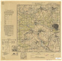
- Description:
- 1931
- Subject:
- Geographic Subject: Klintsy, Topical Subject: Soviet Union, and Topical Subject: Maps
- Publisher:
- Управление военных топографов
- Language:
- Russian
- Identifier:
- VAC9619-001538
- Genre:
- Military Maps and Topographic Maps
- Geographic Location:
- Coordinates: 52.6667, 32, 52.8883, 32.25
- Related URL:
- Download GeoTIFF: https://drive.google.com/file/d/1dqvqLqy6V-1KCxtGxcHOZVnTi23a4KU0/view?usp=sharing and Catalog URL: http://iucat.iu.edu/catalog/5020131
- Abstract:
- Modern area represented: Klintsy, Bryansk oblast, Russia
- Call Number:
- G7000 s50 .S68 sheet N-36-113-D
- Caption:
- Временное издание,Не подлежит оглашению
- City:
- Клинцы (Klintsy)
- Copyright Holder:
- No Copyright - United States
- Country:
- СССР (USSR)
- State/Province:
- Западная область (Western oblast) and РСФСР (RSFSR)
- Physical Description:
- Scale: 1:50,000
- Persistent URL:
- http://purl.dlib.indiana.edu/iudl/images/VAC9619/VAC9619-001538
- Provenance:
- Geographic Names Branch, Library of Congress Geography & Map Division
-
- Description:
- 1931
- Subject:
- Geographic Subject: Gordeyevka, Topical Subject: Maps, and Topical Subject: Soviet Union
- Publisher:
- Управление военных топографов
- Language:
- Russian
- Identifier:
- VAC9619-001536
- Genre:
- Military Maps and Topographic Maps
- Geographic Location:
- Coordinates: 52.8667, 31.75, 53, 32
- Related URL:
- Catalog URL: http://iucat.iu.edu/catalog/5020131 and Download GeoTIFF: https://drive.google.com/open?id=1lfXV3i08W8co2w5TdqscMeABElq769Q5
- Abstract:
- Modern area represented: Gordeyevka, Bryansk oblast, Russia
- Call Number:
- G7000 s50 .S68 sheet N-36-112-B
- Caption:
- Не подлежит оглашению
- City:
- Гордеевка (Gordeyevka)
- Copyright Holder:
- No Copyright - United States
- Country:
- СССР (USSR)
- State/Province:
- РСФСР (RSFSR) and Западная область (Western oblast)
- Physical Description:
- Scale: 1:50,000
- Persistent URL:
- http://purl.dlib.indiana.edu/iudl/images/VAC9619/VAC9619-001536
- Provenance:
- Army Map Service Library, Library of Congress Geography & Map Division, OMAHA
-
- Description:
- 1923
- Subject:
- Geographic Subject: Stolbun, Topical Subject: Maps, and Topical Subject: Soviet Union
- Publisher:
- Военно-топографическое управление
- Language:
- Russian
- Identifier:
- VAC9619-001535
- Genre:
- Topographic Maps and Military Maps
- Geographic Location:
- Coordinates: 52.6667, 31.25, 52.8667, 31.5
- Related URL:
- Download GeoTIFF: https://drive.google.com/open?id=1x_oW83-sSXkR8BnqaGjsW5Tm6V0edZPE and Catalog URL: http://iucat.iu.edu/catalog/5020131
- Abstract:
- Modern area represented: Stolbun, Homyel oblast, Belarus
- Call Number:
- G7000 s50 .S68 sheet N-36-111-D
- Caption:
- Секретно
- City:
- Столбун (Stolbun)
- Copyright Holder:
- No Copyright - United States
- Country:
- СССР (USSR)
- State/Province:
- Белорусская ССР (Byelorussian Soviet Socialist Republic)
- Physical Description:
- Scale: 1:50,000
- Persistent URL:
- http://purl.dlib.indiana.edu/iudl/images/VAC9619/VAC9619-001535
- Provenance:
- Army Map Service Library, Library of Congress Geography & Map Division, OMAHA
-

- Description:
- 1928
- Subject:
- Topical Subject: Soviet Union, Topical Subject: Maps, and Geographic Subject: Kazatskiye Bolsuny
- Publisher:
- Военно-топографическое управление
- Language:
- Russian
- Identifier:
- VAC9619-001534
- Genre:
- Topographic Maps and Military Maps
- Geographic Location:
- Coordinates: 52.8667, 31.25, 53, 32
- Related URL:
- Catalog URL: http://iucat.iu.edu/catalog/5020131 and Download GeoTIFF: https://drive.google.com/open?id=1HkKrlIrLrwWmSzMloRMTx-XUvXR4gx4D
- Abstract:
- Modern area represented: Kazatskiye Bolsuny, Homyel oblast, Belarus
- Call Number:
- G7000 s50 .S68 sheet N-36-111-B
- Caption:
- Секретно
- City:
- Казацкие Болсуны (Kazatskiye Bolsuny)
- Copyright Holder:
- No Copyright - United States
- Country:
- СССР (USSR)
- State/Province:
- Западная область (Western oblast), Белорусская ССР (Byelorussian Soviet Socialist Republic), and РСФСР (RSFSR)
- Physical Description:
- Scale: 1:50,000
- Persistent URL:
- http://purl.dlib.indiana.edu/iudl/images/VAC9619/VAC9619-001534
- Provenance:
- DMA Topographic Center, Army Map Service Library, OMAHA, Library of Congress Geography & Map Division
-
- Description:
- 1928
- Subject:
- Topical Subject: Soviet Union, Geographic Subject: Lokot, and Topical Subject: Maps
- Publisher:
- Управление военных топографов РККА
- Language:
- Russian
- Identifier:
- VAC9619-001533
- Genre:
- Military Maps and Topographic Maps
- Geographic Location:
- Coordinates: 52.8667, 31, 53, 31.25
- Related URL:
- Download GeoTIFF: https://drive.google.com/open?id=1GxpBUovSd_cHLsCzQK6TDAseshOXH1ab and Catalog URL: http://iucat.iu.edu/catalog/5020131
- Abstract:
- Modern area represented: Lokot, Bryansk oblast, Russia
- Call Number:
- G7000 s50 .S68 sheet N-36-111-A
- Caption:
- Не подлежит оглашению
- City:
- Локоть (Lokot)
- Copyright Holder:
- No Copyright - United States
- Country:
- СССР (USSR)
- State/Province:
- Белорусская ССР (Byelorussian Soviet Socialist Republic)
- Physical Description:
- Scale: 1:50,000
- Persistent URL:
- http://purl.dlib.indiana.edu/iudl/images/VAC9619/VAC9619-001533
- Provenance:
- DMA Topographic Center, Army Map Service Library, OMAHA, Library of Congress Geography & Map Division
-
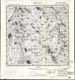
- Description:
- 1914
- Subject:
- Topical Subject: Maps, Topical Subject: Soviet Union, and Geographic Subject: Grosulovo
- Publisher:
- Генеральный штаб РККА
- Language:
- Russian
- Date Created:
- 1933
- Identifier:
- VAC9619-001532
- Genre:
- Military Maps and Topographic Maps
- Geographic Location:
- Coordinates: 47, 29.5, 47.3333, 30
- Related URL:
- Download GeoTIFF: https://drive.google.com/open?id=1kyU5R5m-tJespCHRUtLSwhXDplcG5011 and Catalog URL: https://iucat.iu.edu/catalog/5020129
- Abstract:
- Modern area represented: Grosulovo, Odessa oblast, Ukraine
- Call Number:
- G7000 s100 .S7 sheet L-35-36
- Caption:
- Не подлежит оглашению
- City:
- Гросулово (Grosulovo)
- Copyright Holder:
- No Copyright - United States
- State/Province:
- Молдавская АССР (Moldavian Autonomous Soviet Socialist Republic), Украинская ССР (Ukrainian Soviet Socialist Republic), and Одесская область (Odessa oblast)
- Physical Description:
- Scale: 1:100,000
- Persistent URL:
- http://purl.dlib.indiana.edu/iudl/images/VAC9619/VAC9619-001532
- Provenance:
- CIA Map Library, Atlasblatt
-
- Description:
- 1874
- Subject:
- Topical Subject: Soviet Union, Geographic Subject: Hryhoriopol, and Topical Subject: Maps
- Publisher:
- Генеральный штаб РККА
- Language:
- Russian
- Date Created:
- 1916
- Identifier:
- VAC9619-001531
- Genre:
- Military Maps and Topographic Maps
- Geographic Location:
- Coordinates: 47, 29, 47.3333, 29.5
- Related URL:
- Download GeoTIFF: https://drive.google.com/open?id=19E1iGxfkWQpzLaVEysUOs-ieDNfm5LYO and Catalog URL: https://iucat.iu.edu/catalog/5020129
- Abstract:
- Modern area represented: Hryhoriopol, Stînga Nistrului, Moldova
- Call Number:
- G7000 s100 .S7 sheet L-35-35
- Caption:
- Не подлежит оглашению
- City:
- Григориополь (Hryhoriopol)
- Copyright Holder:
- No Copyright - United States
- State/Province:
- Бессарабия (Bessarabia), Молдавская АССР (Moldavian Autonomous Soviet Socialist Republic), and Украинская ССР (Ukrainian Soviet Socialist Republic)
- Physical Description:
- Scale: 1:100,000
- Persistent URL:
- http://purl.dlib.indiana.edu/iudl/images/VAC9619/VAC9619-001531
- Provenance:
- DMA Topographic Center, Army Map Service Library, Library of Congress Geography & Map Division
-
- Description:
- 1874
- Subject:
- Geographic Subject: Chisinau, Topical Subject: Maps, and Topical Subject: Soviet Union
- Publisher:
- Генеральный штаб РККА
- Language:
- Russian
- Date Created:
- 1916
- Identifier:
- VAC9619-001530
- Genre:
- Military Maps and Topographic Maps
- Geographic Location:
- Coordinates: 47, 28.5, 47.3333, 29
- Related URL:
- Download GeoTIFF: https://drive.google.com/open?id=1xHhtT8h9OlNdn0pYOldU3_y0HXwzxGxP and Catalog URL: https://iucat.iu.edu/catalog/5020129
- Abstract:
- Modern area represented: Chisinau, Chișinău municipality, Moldova
- Call Number:
- G7000 s100 .S7 sheet L-35-34
- City:
- Кишинев (Kischinew)
- Copyright Holder:
- No Copyright - United States
- State/Province:
- Бессарабия (Bessarabia)
- Physical Description:
- Scale: 1:100,000
- Persistent URL:
- http://purl.dlib.indiana.edu/iudl/images/VAC9619/VAC9619-001530
- Provenance:
- DMA Topographic Center, Army Map Service Library, OMAHA, Library of Congress Geography & Map Division, Reichsamt für Landesaufnahme, Kartensammlung
-
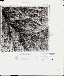
- Description:
- 1873
- Subject:
- Topical Subject: Soviet Union, Topical Subject: Maps, and Geographic Subject: Călărasi-Targ
- Publisher:
- Генеральный штаб РККА
- Language:
- Russian
- Date Created:
- 1940
- Identifier:
- VAC9619-001529
- Genre:
- Topographic Maps and Military Maps
- Geographic Location:
- Coordinates: 47, 28, 47.3333, 28.5
- Related URL:
- Download GeoTIFF: https://drive.google.com/open?id=1tChuAu9yqWs5ys8Z7tNhOEmgq69Apb3I and Catalog URL: https://iucat.iu.edu/catalog/5020129
- Abstract:
- Modern area represented: Călărasi-Targ, Călăraşi county, Moldova
- Call Number:
- G7000 s100 .S7 sheet L-35-33
- City:
- Калараш-Тырг (Călărasi-Targ)
- Copyright Holder:
- No Copyright - United States
- Country:
- Румыния (Romania)
- State/Province:
- Бессарабия (Bessarabia)
- Physical Description:
- Scale: 1:100,000
- Persistent URL:
- http://purl.dlib.indiana.edu/iudl/images/VAC9619/VAC9619-001529
- Provenance:
- CIA Map Library
-
- Description:
- 1928
- Subject:
- Geographic Subject: Prisno, Topical Subject: Soviet Union, and Topical Subject: Maps
- Publisher:
- Управление военных топографов
- Language:
- Russian
- Identifier:
- VAC9619-001528
- Genre:
- Topographic Maps and Military Maps
- Geographic Location:
- Coordinates: 52.6667, 30.75, 53, 31
- Related URL:
- Catalog URL: http://iucat.iu.edu/catalog/5020131 and Download GeoTIFF: https://drive.google.com/open?id=1FXKHO5tXHr9fKZjzS1o03TiZjtGCy1Nb
- Abstract:
- Modern area represented: Prisno, Homyel oblast, Belarus
- Call Number:
- G7000 s50 .S68 sheet N-36-110-D
- Caption:
- Не подлежит оглашению
- City:
- Присно (Prisno)
- Copyright Holder:
- No Copyright - United States
- Country:
- СССР (USSR)
- State/Province:
- Белорусская ССР (Byelorussian Soviet Socialist Republic)
- Physical Description:
- Scale: 1:50,000
- Persistent URL:
- http://purl.dlib.indiana.edu/iudl/images/VAC9619/VAC9619-001528
- Provenance:
- DMA Topographic Center, Army Map Service Library, OMAHA, Library of Congress Geography & Map Division
-
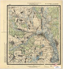
- Description:
- 1928
- Subject:
- Geographic Subject: Chachersk, Topical Subject: Soviet Union, and Topical Subject: Maps
- Publisher:
- Управление военных топографов РККА
- Language:
- Russian
- Identifier:
- VAC9619-001527
- Genre:
- Military Maps and Topographic Maps
- Geographic Location:
- Coordinates: 52.8667, 30.75, 53, 31
- Related URL:
- Download GeoTIFF: https://drive.google.com/open?id=1RPjzGng7eepaGYTUl-mzYLHkDbgHoeKH and Catalog URL: http://iucat.iu.edu/catalog/5020131
- Abstract:
- Modern area represented: Chachersk, Homyel oblast, Belarus
- Call Number:
- G7000 s50 .S68 sheet N-36-110-B
- Caption:
- Не подлежит оглашению
- City:
- Чечерск (Chachersk)
- Copyright Holder:
- No Copyright - United States
- Country:
- СССР (USSR)
- State/Province:
- Белорусская ССР (Byelorussian Soviet Socialist Republic)
- Physical Description:
- Scale: 1:50,000
- Persistent URL:
- http://purl.dlib.indiana.edu/iudl/images/VAC9619/VAC9619-001527
- Provenance:
- CIA Map Branch -- Received
-
- Description:
- 1936
- Subject:
- Topical Subject: Maps, Topical Subject: Soviet Union, and Geographic Subject: Streshin
- Publisher:
- Управление военных топографов РККА
- Language:
- Russian
- Identifier:
- VAC9619-001525
- Genre:
- Military Maps and Topographic Maps
- Geographic Location:
- Coordinates: 52.6667, 30, 52.8667, 30.25
- Related URL:
- Download GeoTIFF: https://drive.google.com/open?id=1POH65OMgnURYlMeEUDZP_BQqT3DVBuiW and Catalog URL: http://iucat.iu.edu/catalog/5020131
- Abstract:
- Modern area represented: Streshin, Homyel oblast, Belarus
- Call Number:
- G7000 s50 .S68 sheet N-36-109-В
- Caption:
- Не подлежит оглашению
- City:
- Стрешин (Streshin)
- Copyright Holder:
- No Copyright - United States
- Country:
- СССР (USSR)
- State/Province:
- Белорусская ССР (Byelorussian Soviet Socialist Republic)
- Physical Description:
- Scale: 1:50,000
- Persistent URL:
- http://purl.dlib.indiana.edu/iudl/images/VAC9619/VAC9619-001525
- Provenance:
- M. I. Map Library, G000-30, GS, RA
-
- Description:
- 1936
- Subject:
- Topical Subject: Maps, Topical Subject: Soviet Union, and Geographic Subject: Pirevichi
- Publisher:
- Управление военных топографов РККА
- Language:
- Russian
- Identifier:
- VAC9619-001526
- Genre:
- Military Maps and Topographic Maps
- Geographic Location:
- Coordinates: 52.6667, 30.25, 52.8667, 30.5
- Related URL:
- Catalog URL: http://iucat.iu.edu/catalog/5020131 and Download GeoTIFF: https://drive.google.com/open?id=1SuiL1h908k5bv94WoCYDQGl9cO2COwsi
- Abstract:
- Modern area represented: Pirevichi, Homyel oblast, Belarus
- Call Number:
- G7000 s50 .S68 sheet N-36-109-D
- Caption:
- Не подлежит оглашению
- City:
- Пиревичи (Pirevichi)
- Copyright Holder:
- No Copyright - United States
- Country:
- СССР (USSR)
- State/Province:
- Белорусская ССР (Byelorussian Soviet Socialist Republic)
- Physical Description:
- Scale: 1:50,000
- Persistent URL:
- http://purl.dlib.indiana.edu/iudl/images/VAC9619/VAC9619-001526
- Provenance:
- M. I. Map Library, G000-30, Atlasblatt
-
- Description:
- 1936
- Subject:
- Geographic Subject: Haradzyets, Topical Subject: Maps, and Topical Subject: Soviet Union
- Publisher:
- Управление военных топографов РККА
- Language:
- Russian
- Identifier:
- VAC9619-001524
- Genre:
- Military Maps and Topographic Maps
- Geographic Location:
- Coordinates: 52.8667, 30.25, 53, 30.5
- Related URL:
- Catalog URL: http://iucat.iu.edu/catalog/5020131 and Download GeoTIFF: https://drive.google.com/open?id=1VRkMyY6QsSsD6dvSqS6d99enfzkd3eZr
- Abstract:
- Modern area represented: Haradzyets, Homyel oblast, Belarus
- Call Number:
- G7000 s50 .S68 sheet N-36-109-B
- Caption:
- Не подлежит оглашению
- City:
- Городец (Haradzyets)
- Copyright Holder:
- No Copyright - United States
- Country:
- СССР (USSR)
- State/Province:
- Белорусская ССР (Byelorussian Soviet Socialist Republic)
- Physical Description:
- Scale: 1:50,000
- Persistent URL:
- http://purl.dlib.indiana.edu/iudl/images/VAC9619/VAC9619-001524
- Provenance:
- M. I. Map Library, Atlasblatt
-
- Description:
- 1931
- Subject:
- Geographic Subject: Zhlobin, Topical Subject: Soviet Union, and Topical Subject: Maps
- Publisher:
- Управление военных топографов РККА
- Language:
- Russian
- Date Created:
- 1936
- Identifier:
- VAC9619-001523
- Genre:
- Topographic Maps and Military Maps
- Geographic Location:
- Coordinates: 52.8667, 30, 53, 30.25
- Related URL:
- Download GeoTIFF: https://drive.google.com/open?id=1fegM38JGNEzEvDxv5geRA4ZAE-L4Nox_ and Catalog URL: http://iucat.iu.edu/catalog/5020131
- Abstract:
- Modern area represented: Zhlobin, Homyel oblast, Belarus
- Call Number:
- G7000 s50 .S68 sheet N-36-109-A
- Caption:
- Не подлежит оглашению
- City:
- Жлобин (Zhlobin)
- Copyright Holder:
- No Copyright - United States
- Country:
- СССР (USSR)
- State/Province:
- Белорусская ССР (Byelorussian Soviet Socialist Republic)
- Physical Description:
- Scale: 1:50,000
- Persistent URL:
- http://purl.dlib.indiana.edu/iudl/images/VAC9619/VAC9619-001523
- Provenance:
- CIA Map Branch -- Received
-
- Description:
- 1940
- Subject:
- Geographic Subject: Paramonovo, Topical Subject: Maps, and Topical Subject: Soviet Union
- Publisher:
- Главное Управление Геодезии и Картографии при СНК СССР
- Language:
- Russian
- Date Created:
- 1941
- Identifier:
- VAC9619-001521
- Genre:
- Military Maps and Topographic Maps
- Geographic Location:
- Coordinates: 53, 35.5, 53.1667, 35.75
- Related URL:
- Catalog URL: http://iucat.iu.edu/catalog/5020131 and Download GeoTIFF: https://drive.google.com/open?id=1UVww6BGdkAqeLlWDPAX8mWZ-JNBffhZ8
- Abstract:
- Modern area represented: Paramonovo, Oryol oblast, Russia
- Call Number:
- G7000 s50 .S68 sheet N-36-108-C
- Caption:
- Для служебного пользования
- City:
- Парамоново (Paramonovo)
- Copyright Holder:
- No Copyright - United States
- Country:
- СССР (USSR)
- State/Province:
- Орловская область (Oryol oblast) and РСФСР (RSFSR)
- Physical Description:
- Scale: 1:50,000
- Persistent URL:
- http://purl.dlib.indiana.edu/iudl/images/VAC9619/VAC9619-001521
- Provenance:
- Library of Congress Geography & Map Division
-
- Description:
- 1940
- Subject:
- Geographic Subject: Maslovo, Topical Subject: Soviet Union, and Topical Subject: Maps
- Publisher:
- Главное Управление Геодезии и Картографии при СНК СССР
- Language:
- Russian
- Date Created:
- 1941
- Identifier:
- VAC9619-001522
- Genre:
- Topographic Maps and Military Maps
- Geographic Location:
- Coordinates: 53, 35.75, 53.1667, 36
- Related URL:
- Catalog URL: http://iucat.iu.edu/catalog/5020131 and Download GeoTIFF: https://drive.google.com/open?id=1bOKSndLSuBLgski4Ip3p_I3fSFaHmjM9
- Abstract:
- Modern area represented: Maslovo, Oryol oblast, Russia
- Call Number:
- G7000 s50 .S68 sheet N-36-108-D
- Caption:
- Для служебного пользования
- City:
- Маслово (Maslovo)
- Copyright Holder:
- No Copyright - United States
- Country:
- СССР (USSR)
- State/Province:
- РСФСР (RSFSR) and Орловская область (Oryol oblast)
- Physical Description:
- Scale: 1:50,000
- Persistent URL:
- http://purl.dlib.indiana.edu/iudl/images/VAC9619/VAC9619-001522
- Provenance:
- M. I. Map Library, Library of Congress Geography & Map Division
-
- Description:
- 1940
- Subject:
- Geographic Subject: Zlyn, Topical Subject: Soviet Union, and Topical Subject: Maps
- Publisher:
- Главное Управление Геодезии и Картографии при СНК СССР
- Language:
- Russian
- Date Created:
- 1941
- Identifier:
- VAC9619-001520
- Genre:
- Military Maps and Topographic Maps
- Geographic Location:
- Coordinates: 53.1667, 35.75, 53.3333, 36
- Related URL:
- Download GeoTIFF: https://drive.google.com/open?id=1EHCOZM804wazDUaEd-ANaCFuKoU3Oqcv and Catalog URL: http://iucat.iu.edu/catalog/5020131
- Abstract:
- Modern area represented: Zlyn, Oryol oblast, Russia
- Call Number:
- G7000 s50 .S68 sheet N-36-108-B
- City:
- Злынь (Zlyn)
- Copyright Holder:
- No Copyright - United States
- Country:
- СССР (USSR)
- State/Province:
- Орловская область (Oryol oblast) and РСФСР (RSFSR)
- Physical Description:
- Scale: 1:50,000
- Persistent URL:
- http://purl.dlib.indiana.edu/iudl/images/VAC9619/VAC9619-001520
- Provenance:
- Library of Congress Geography & Map Division, Atlasblatt
-
- Description:
- 1941
- Subject:
- Geographic Subject: Znamenskoye, Topical Subject: Maps, and Topical Subject: Soviet Union
- Publisher:
- Главное Управление Геодезии и Картографии при СНК СССР
- Language:
- Russian
- Identifier:
- VAC9619-001519
- Genre:
- Military Maps and Topographic Maps
- Geographic Location:
- Coordinates: 53.1667, 53.5, 53.3333, 53.75
- Related URL:
- Catalog URL: http://iucat.iu.edu/catalog/5020131 and Download GeoTIFF: https://drive.google.com/open?id=1KIu-SL96Usaft6zNXT3wnMwet1Lo-NdI
- Abstract:
- Modern area represented: Znamenskoye, Oryol oblast, Russia
- Call Number:
- G7000 s50 .S68 sheet N-36-108-A
- City:
- Знаменское (Znamenskoye)
- Copyright Holder:
- No Copyright - United States
- Country:
- СССР (USSR)
- State/Province:
- Орловская область (Oryol oblast) and РСФСР (RSFSR)
- Physical Description:
- Scale: 1:50,000
- Persistent URL:
- http://purl.dlib.indiana.edu/iudl/images/VAC9619/VAC9619-001519
- Provenance:
- Library of Congress Geography & Map Division, Atlasblatt
-
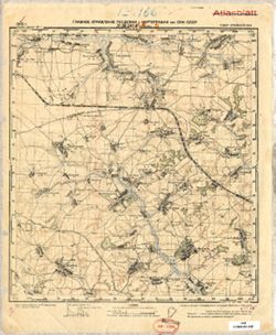
- Description:
- 1940
- Subject:
- Topical Subject: Maps, Geographic Subject: Khotynets, and Topical Subject: Soviet Union
- Publisher:
- Главное Управление Геодезии и Картографии при СНК СССР
- Language:
- Russian
- Date Created:
- 1941
- Identifier:
- VAC9619-001518
- Genre:
- Military Maps and Topographic Maps
- Geographic Location:
- Coordinates: 53, 35.25, 53.1667, 35.5
- Related URL:
- Catalog URL: http://iucat.iu.edu/catalog/5020131 and Download GeoTIFF: https://drive.google.com/open?id=1Isufcm9gef7dUIdR8oxJMpGgL3l2Ti5V
- Abstract:
- Modern area represented: Khotynets, Oryol oblast, Russia
- Call Number:
- G7000 s50 .S68 sheet N-36-107-D
- City:
- Хотынец (Khotynets)
- Copyright Holder:
- No Copyright - United States
- Country:
- СССР (USSR)
- State/Province:
- РСФСР (RSFSR) and Орловская область (Oryol oblast)
- Physical Description:
- Scale: 1:50,000
- Persistent URL:
- http://purl.dlib.indiana.edu/iudl/images/VAC9619/VAC9619-001518
- Provenance:
- Library of Congress Geography & Map Division, Atlasblatt
-
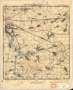
- Description:
- 1940
- Subject:
- Geographic Subject: Karachev, Topical Subject: Soviet Union, and Topical Subject: Maps
- Publisher:
- Главное Управление Геодезии и Картографии при СНК СССР
- Language:
- Russian
- Date Created:
- 1941
- Identifier:
- VAC9619-001517
- Genre:
- Topographic Maps and Military Maps
- Geographic Location:
- Coordinates: 53, 35, 53.1667, 35.25
- Related URL:
- Download GeoTIFF: https://drive.google.com/open?id=1tx376Leo0Op2xASywUmrrK0sSi1MmuNZ and Catalog URL: http://iucat.iu.edu/catalog/5020131
- Abstract:
- Modern area represented: Karachev, Bryansk oblast, Russia
- Call Number:
- G7000 s50 .S68 sheet N-36-107-C
- City:
- Карачев (Karachev)
- Copyright Holder:
- No Copyright - United States
- Country:
- СССР (USSR)
- State/Province:
- Орловская область (Oryol oblast) and РСФСР (RSFSR)
- Physical Description:
- Scale: 1:50,000
- Persistent URL:
- http://purl.dlib.indiana.edu/iudl/images/VAC9619/VAC9619-001517
- Provenance:
- Library of Congress Geography & Map Division
-
- Description:
- 1930
- Subject:
- Topical Subject: Maps, Geographic Subject: Karachev, and Topical Subject: Soviet Union
- Publisher:
- Генеральный штаб Красной Армии
- Language:
- Russian
- Date Created:
- 1934
- Identifier:
- VAC9619-001515
- Genre:
- Military Maps and Topographic Maps
- Geographic Location:
- Coordinates: 53, 34.75, 53.1667, 35
- Related URL:
- Download GeoTIFF: https://drive.google.com/open?id=1-vuslDMvcniebltWqDqKlpmiZ2TicsHw and Catalog URL: http://iucat.iu.edu/catalog/5020131
- Abstract:
- Modern area represented: Karachev, Bryansk oblast, Russia
- Call Number:
- G7000 s50 .S68 sheet N-36-106-D
- City:
- Карачев (Karachev)
- Copyright Holder:
- No Copyright - United States
- Country:
- СССР (USSR)
- State/Province:
- РСФСР (RSFSR) and Орловская область (Oryol oblast)
- Physical Description:
- Scale: 1:50,000
- Persistent URL:
- http://purl.dlib.indiana.edu/iudl/images/VAC9619/VAC9619-001515
- Provenance:
- Army Map Service Library, Library of Congress Geography & Map Division, OMAHA
-
- Description:
- 1940
- Subject:
- Topical Subject: Maps, Geographic Subject: Alekhino, and Topical Subject: Soviet Union
- Publisher:
- Главное Управление Геодезии и Картографии при СНК СССР
- Language:
- Russian
- Date Created:
- 1941
- Identifier:
- VAC9619-001516
- Genre:
- Topographic Maps and Military Maps
- Geographic Location:
- Coordinates: 53.1667, 35, 53.3333, 35.25
- Related URL:
- Download GeoTIFF: https://drive.google.com/open?id=1Cq4nFCMIfKx6u7dZkeCdFvA3RIKV4c5Z and Catalog URL: http://iucat.iu.edu/catalog/5020131
- Abstract:
- Modern area represented: Alekhino, Oryol oblast, Russia
- Call Number:
- G7000 s50 .S68 sheet N-36-107-A
- City:
- Алехино (Alekhino)
- Copyright Holder:
- No Copyright - United States
- Country:
- СССР (USSR)
- State/Province:
- РСФСР (RSFSR) and Орловская область (Oryol oblast)
- Physical Description:
- Scale: 1:50,000
- Persistent URL:
- http://purl.dlib.indiana.edu/iudl/images/VAC9619/VAC9619-001516
- Provenance:
- DMA Topographic Center, Army Map Service Library, OMAHA, Library of Congress Geography & Map Division
-
- Description:
- 1930
- Subject:
- Topical Subject: Soviet Union, Topical Subject: Maps, and Geographic Subject: Verkhopolye
- Publisher:
- Генеральный штаб Красной Армии
- Language:
- Russian
- Date Created:
- 1934
- Identifier:
- VAC9619-001514
- Genre:
- Topographic Maps and Military Maps
- Geographic Location:
- Coordinates: 53, 34.5, 53.1667, 34.75
- Related URL:
- Catalog URL: http://iucat.iu.edu/catalog/5020131 and Download GeoTIFF: https://drive.google.com/open?id=1w15QboP6wPbee79SikaUleyski-x_Eeq
- Abstract:
- Modern area represented: Verkhopolye, Bryansk oblast, Russia
- Call Number:
- G7000 s50 .S68 sheet N-36-106-C
- City:
- Верхополье (Verkhopolye)
- Copyright Holder:
- No Copyright - United States
- Country:
- СССР (USSR)
- State/Province:
- Орловская область (Oryol oblast) and РСФСР (RSFSR)
- Physical Description:
- Scale: 1:50,000
- Persistent URL:
- http://purl.dlib.indiana.edu/iudl/images/VAC9619/VAC9619-001514
- Provenance:
- DMA Topographic Center, Army Map Service Library, OMAHA, Library of Congress Geography & Map Division
-
- Description:
- 1894
- Subject:
- Geographic Subject: Târgu Frumos, Topical Subject: Maps, and Topical Subject: Soviet Union
- Publisher:
- Управление военных топографов РККА
- Language:
- Russian
- Date Created:
- 1895
- Identifier:
- VAC9619-001513
- Genre:
- Topographic Maps and Military Maps
- Geographic Location:
- Coordinates: 47, 27, 47.3333, 27.5
- Related URL:
- Catalog URL: https://iucat.iu.edu/catalog/5020129 and Download GeoTIFF: https://drive.google.com/open?id=1LC0U4QZ-lg_KQMIgNHXryuR7uKbf-_vN
- Abstract:
- Modern area represented: Târgu Frumos, Iași county, Romania
- Call Number:
- G7000 s100 .S7 sheet L-35-31
- City:
- Тыргул Фрумос (Târgu Frumos)
- Copyright Holder:
- No Copyright - United States
- Country:
- Румыния (Romania)
- Physical Description:
- Scale: 1:100,000
- Persistent URL:
- http://purl.dlib.indiana.edu/iudl/images/VAC9619/VAC9619-001513
- Provenance:
- DMA Topographic Center, Army Map Service Library, Library of Congress Geography & Map Division
-
- Description:
- 1930
- Subject:
- Geographic Subject: Pesochnya, Topical Subject: Maps, and Topical Subject: Soviet Union
- Publisher:
- Управление военных топографов
- Language:
- Russian
- Identifier:
- VAC9619-001512
- Genre:
- Military Maps and Topographic Maps
- Geographic Location:
- Coordinates: 53.1667, 34.75, 53.3333, 35
- Related URL:
- Download GeoTIFF: https://drive.google.com/file/d/1QFFgZ3SM6N5BV4vJnRTHw8XHZgHqSF8y/view?usp=sharing and Catalog URL: http://iucat.iu.edu/catalog/5020131
- Abstract:
- Modern area represented: Pesochnya, Bryansk oblast, Russia
- Call Number:
- G7000 s50 .S68 sheet N-36-106-B
- Caption:
- Не подлежит оглашению
- City:
- Песочня (Pesochnya)
- Copyright Holder:
- No Copyright - United States
- Country:
- СССР (USSR)
- State/Province:
- РСФСР (RSFSR) and Западная область (Western oblast)
- Physical Description:
- Scale: 1:50,000
- Persistent URL:
- http://purl.dlib.indiana.edu/iudl/images/VAC9619/VAC9619-001512
- Provenance:
- Army Map Service Library, Library of Congress Geography & Map Division, OMAHA
-
- Description:
- 1930
- Subject:
- Geographic Subject: Pesochnya, Topical Subject: Soviet Union, and Topical Subject: Maps
- Publisher:
- Генеральный штаб Красной Армии
- Language:
- Russian
- Date Created:
- 1934
- Identifier:
- VAC9619-001511
- Genre:
- Military Maps and Topographic Maps
- Geographic Location:
- Coordinates: 53.1667, 34.75, 53.3333, 35
- Related URL:
- Catalog URL: http://iucat.iu.edu/catalog/5020131 and Download GeoTIFF: https://drive.google.com/open?id=1Fv5hKojHT879CoFefVH-sXivVov9Vzam
- Abstract:
- Modern area represented: Pesochnya, Bryansk oblast, Russia
- Call Number:
- G7000 s50 .S68 sheet N-36-106-B
- City:
- Песочня (Pesochnya)
- Copyright Holder:
- No Copyright - United States
- Country:
- СССР (USSR)
- State/Province:
- РСФСР (RSFSR) and Орловская область (Oryol oblast)
- Physical Description:
- Scale: 1:50,000
- Persistent URL:
- http://purl.dlib.indiana.edu/iudl/images/VAC9619/VAC9619-001511
- Provenance:
- DMA Topographic Center, Army Map Service Library, Library of Congress Geography & Map Division
-
- Description:
- 1930
- Subject:
- Topical Subject: Soviet Union, Geographic Subject: Bryansk, and Topical Subject: Maps
- Publisher:
- Управление военных топографов
- Language:
- Russian
- Identifier:
- VAC9619-001509
- Genre:
- Topographic Maps and Military Maps
- Geographic Location:
- Coordinates: 53.1667, 34.25, 53.3333, 34.5
- Related URL:
- Catalog URL: http://iucat.iu.edu/catalog/5020131 and Download GeoTIFF: https://drive.google.com/open?id=1AMeuFn53nvguczh5frEiSHH6hMAOEjko
- Abstract:
- Modern area represented: Bryansk, Bryansk oblast, Russia
- Call Number:
- G7000 s50 .S68 sheet N-36-105-B
- Caption:
- Не подлежит оглашению
- City:
- Брянск (Bryansk)
- Copyright Holder:
- No Copyright - United States
- Country:
- СССР (USSR)
- State/Province:
- Западная область (Western oblast) and РСФСР (RSFSR)
- Physical Description:
- Scale: 1:50,000
- Persistent URL:
- http://purl.dlib.indiana.edu/iudl/images/VAC9619/VAC9619-001509
- Provenance:
- DMA Topographic Center, Army Map Service Library, Library of Congress Geography & Map Division
-
- Description:
- 1930
- Subject:
- Topical Subject: Maps, Topical Subject: Soviet Union, and Geographic Subject: Belyye Berega
- Publisher:
- Генеральный штаб Красной Армии
- Language:
- Russian
- Date Created:
- 1934
- Identifier:
- VAC9619-001510
- Genre:
- Military Maps and Topographic Maps
- Geographic Location:
- Coordinates: 53.1667, 34.5, 53.3333, 34.75
- Related URL:
- Catalog URL: http://iucat.iu.edu/catalog/5020131 and Download GeoTIFF: https://drive.google.com/open?id=1pDagSk-xo3nE1gX3nPO98PBZ011Xdi71
- Abstract:
- Modern area represented: Belyye Berega, Bryansk oblast, Russia
- Call Number:
- G7000 s50 .S68 sheet N-36-106-A
- City:
- Ст. Белые Берега (Belyye Berega)
- Copyright Holder:
- No Copyright - United States
- Country:
- СССР (USSR)
- State/Province:
- Орловская область (Oryol oblast) and РСФСР (RSFSR)
- Physical Description:
- Scale: 1:50,000
- Persistent URL:
- http://purl.dlib.indiana.edu/iudl/images/VAC9619/VAC9619-001510
- Provenance:
- DMA Topographic Center, Army Map Service Library, Library of Congress Geography & Map Division
-
- Description:
- 1930
- Subject:
- Topical Subject: Soviet Union, Topical Subject: Maps, and Geographic Subject: Dobrun
- Publisher:
- Управление военных топографов
- Language:
- Russian
- Identifier:
- VAC9619-001508
- Genre:
- Military Maps and Topographic Maps
- Geographic Location:
- Coordinates: 53.1667, 34, 53.3333, 34.25
- Related URL:
- Catalog URL: http://iucat.iu.edu/catalog/5020131 and Download GeoTIFF: https://drive.google.com/open?id=13TnhKHEgeF4iPmiKD-XhEjMGOHHFgg_k
- Abstract:
- Modern area represented: Dobrun, Bryansk oblast, Russia
- Call Number:
- G7000 s50 .S68 sheet N-36-105-A
- Caption:
- Не подлежит оглашению
- City:
- Добрунь (Dobrun)
- Copyright Holder:
- No Copyright - United States
- Country:
- СССР (USSR)
- State/Province:
- Западная область (Western oblast) and РСФСР (RSFSR)
- Physical Description:
- Scale: 1:50,000
- Persistent URL:
- http://purl.dlib.indiana.edu/iudl/images/VAC9619/VAC9619-001508
- Provenance:
- Army Map Service Library, Library of Congress Geography & Map Division, OMAHA
-
- Description:
- 1914
- Subject:
- Geographic Subject: Podilsk, Topical Subject: Maps, and Topical Subject: Soviet Union
- Publisher:
- Управление военных топографов РККА
- Language:
- Russian
- Date Created:
- 1932
- Identifier:
- VAC9619-001507
- Genre:
- Topographic Maps and Military Maps
- Geographic Location:
- Coordinates: 47.6667, 29.5, 48, 30
- Related URL:
- Download GeoTIFF: https://drive.google.com/file/d/1yoB4gIhyBxqMxVG2YSUt4dy0IT4GLUCb/view?usp=sharing and Catalog URL: https://iucat.iu.edu/catalog/5020129
- Abstract:
- Modern area represented: Podilsk, Odessa oblast, Ukraine
- Call Number:
- G7000 s100 .S7 sheet L-35-12
- Caption:
- Не подлежит оглашению
- City:
- Котовск (Kotovsk)
- Copyright Holder:
- No Copyright - United States
- Country:
- СССР (USSR)
- State/Province:
- Украинская ССР (Ukrainian Soviet Socialist Republic), Одесская область (Odessa oblast), and Молдавская АССР (Moldavian Autonomous Soviet Socialist Republic)
- Physical Description:
- Scale: 1:100,000
- Persistent URL:
- http://purl.dlib.indiana.edu/iudl/images/VAC9619/VAC9619-001507
- Provenance:
- DMA Topographic Center, Army Map Service Library, OMAHA, Library of Congress Geography & Map Division, Auswärtiges Amt. Geographischer Dienst
-
- Description:
- 1930
- Subject:
- Topical Subject: Soviet Union, Topical Subject: Maps, and Geographic Subject: Akulichi
- Publisher:
- Управление военных топографов
- Language:
- Russian
- Identifier:
- VAC9619-001506
- Genre:
- Topographic Maps and Military Maps
- Geographic Location:
- Coordinates: 53.167, 33, 53.333, 33.25
- Related URL:
- Catalog URL: http://iucat.iu.edu/catalog/5020131 and Download GeoTIFF: https://drive.google.com/open?id=1bubHqXRJ9n_JRwrzGYd2eant8e1gVksX
- Abstract:
- Modern area represented: Akulichi, Russia
- Call Number:
- G7000 s50 .S68 sheet N-36-103-A
- Caption:
- Не подлежит оглашению
- City:
- Акуличи (Akulichi)
- Copyright Holder:
- No Copyright - United States
- Country:
- СССР (USSR)
- State/Province:
- РСФСР (RSFSR), Брянск область (Bryansk oblast), and Западная область (Western oblast)
- Physical Description:
- Scale: 1:50,000
- Persistent URL:
- http://purl.dlib.indiana.edu/iudl/images/VAC9619/VAC9619-001506
- Provenance:
- DMA Topographic Center, Army Map Service Library, Library of Congress G & M Division
-
- Description:
- 1930
- Subject:
- Topical Subject: Soviet Union, Topical Subject: Maps, and Geographic Subject: Mglin
- Publisher:
- Управление военных топографов
- Language:
- Russian
- Identifier:
- VAC9619-001505
- Genre:
- Military Maps and Topographic Maps
- Geographic Location:
- Coordinates: 53, 32.75, 53.1667, 33
- Related URL:
- Download GeoTIFF: https://drive.google.com/open?id=1dqFcgG6gdFbq-GqLVtGBaaNwXPbGn7Rs and Catalog URL: http://iucat.iu.edu/catalog/5020131
- Abstract:
- Modern area represented: Mglin, Bryansk oblast, Russia
- Call Number:
- G7000 s50 .S68 sheet N-36-102-Г
- Caption:
- Не подлежит оглашению
- City:
- Мглин (Mglin)
- Copyright Holder:
- No Copyright - United States
- Country:
- СССР (USSR)
- State/Province:
- РСФСР (RSFSR) and Западная область (Western oblast)
- Physical Description:
- Scale: 1:50,000
- Persistent URL:
- http://purl.dlib.indiana.edu/iudl/images/VAC9619/VAC9619-001505
- Provenance:
- Army Map Service Library, Library of Congress Geography & Map Division, OMAHA
-
- Description:
- 1872
- Subject:
- Topical Subject: Soviet Union, Geographic Subject: Ștefănești, and Topical Subject: Maps
- Publisher:
- Генеральный штаб РККА
- Language:
- Russian
- Date Created:
- 1894
- Identifier:
- VAC9619-001501
- Genre:
- Topographic Maps and Military Maps
- Geographic Location:
- Coordinates: 47.6667, 27, 48, 27.5
- Related URL:
- Catalog URL: https://iucat.iu.edu/catalog/5020129 and Download GeoTIFF: https://drive.google.com/file/d/1nXQvyN3376WtIPrwNB28E_5MwcpntFKz/view?usp=sharing
- Abstract:
- Modern area represented: Ștefănești, Rîşcani district, Moldova
- Call Number:
- G7000 s100 .S7 sheet L-35-7
- City:
- Стэфанештий (Ștefănești)
- Copyright Holder:
- No Copyright - United States
- Country:
- Румыния (Romania)
- State/Province:
- Бессарабия (Bessarabia)
- Physical Description:
- Scale: 1:100,000
- Persistent URL:
- http://purl.dlib.indiana.edu/iudl/images/VAC9619/VAC9619-001501
- Provenance:
- DMA Topographic Center, Army Map Service Library, OMAHA, Library of Congress Geography & Map Division, Atlasblatt
-
- Description:
- 1931
- Subject:
- Topical Subject: Soviet Union, Topical Subject: Maps, and Geographic Subject: Bolotnya
- Publisher:
- Управление военных топографов
- Language:
- Russian
- Identifier:
- VAC9619-001504
- Genre:
- Military Maps and Topographic Maps
- Geographic Location:
- Coordinates: 53.1667, 32.75, 53.3333, 33
- Related URL:
- Download GeoTIFF: https://drive.google.com/file/d/1DND7UENKh3QT4-FNIuxE4qh94CJeHGgb/view?usp=sharing and Catalog URL: http://iucat.iu.edu/catalog/5020131
- Abstract:
- Modern area represented: Bolotnya, Bryansk oblast, Russia
- Call Number:
- G7000 s50 .S68 sheet N-36-105-B
- Caption:
- Не подлежит оглашению
- City:
- Болотня (Bolotnya)
- Copyright Holder:
- No Copyright - United States
- Country:
- СССР (USSR)
- State/Province:
- РСФСР (RSFSR) and Западная область (Western oblast)
- Physical Description:
- Scale: 1:50,000
- Persistent URL:
- http://purl.dlib.indiana.edu/iudl/images/VAC9619/VAC9619-001504
- Provenance:
- DMA Topographic Center, Army Map Service Library, OMAHA, Library of Congress Geography & Map Division
-
- Description:
- 1914
- Subject:
- Topical Subject: Maps, Topical Subject: Soviet Union, and Geographic Subject: Podilsk
- Publisher:
- Управление военных топографов РККА
- Language:
- Russian
- Date Created:
- 1932
- Identifier:
- VAC9619-001503
- Genre:
- Topographic Maps and Military Maps
- Geographic Location:
- Coordinates: 47.6667, 29.5, 48, 30
- Related URL:
- Catalog URL: https://iucat.iu.edu/catalog/5020129 and Download GeoTIFF: https://drive.google.com/open?id=1GY1T_2cRAKuBJomRz9ZEfhqJTuF0vfG8
- Abstract:
- Modern area represented: Podilsk, Odessa oblast, Ukraine
- Call Number:
- G7000 s100 .S7 sheet L-35-12
- Caption:
- Не подлежит оглашению
- City:
- Котовск (Kotovsk)
- Copyright Holder:
- No Copyright - United States
- Country:
- СССР (USSR)
- State/Province:
- Одесская область (Odessa oblast), Украинская ССР (Ukrainian Soviet Socialist Republic), and Молдавская АССР (Moldavian Autonomous Soviet Socialist Republic)
- Physical Description:
- Scale: 1:100,000
- Persistent URL:
- http://purl.dlib.indiana.edu/iudl/images/VAC9619/VAC9619-001503
- Provenance:
- CIA Map Library, Auswärtiges Amt. Geographischer Dienst
-
- Description:
- 1873
- Subject:
- Topical Subject: Maps, Topical Subject: Soviet Union, and Geographic Subject: Slobidka
- Publisher:
- Генеральный штаб РККА
- Language:
- Russian
- Date Created:
- 1933
- Identifier:
- VAC9619-001502
- Genre:
- Military Maps and Topographic Maps
- Geographic Location:
- Coordinates: 47.6667, 29, 48, 29.5
- Related URL:
- Download GeoTIFF: https://drive.google.com/open?id=12hPOl2XNIpsYO7n4_yTuCA5VYkAUpSEV and Catalog URL: https://iucat.iu.edu/catalog/5020129
- Abstract:
- Modern area represented: Slobidka, Odessa oblast, Ukraine
- Call Number:
- G7000 s100 .S7 sheet L-35-11
- Caption:
- Не подлежит оглашению
- City:
- Пос. Слободка (Slobodka village)
- Copyright Holder:
- No Copyright - United States
- State/Province:
- Украинская ССР (Ukrainian Soviet Socialist Republic), Бессарабия (Bessarabia), and Молдавская АССР (Moldavian Autonomous Soviet Socialist Republic)
- Physical Description:
- Scale: 1:100,000
- Persistent URL:
- http://purl.dlib.indiana.edu/iudl/images/VAC9619/VAC9619-001502
- Provenance:
- CIA Map Library
