
Search Constraints
Search Results
-
- Subject:
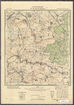
- Topical Subject: Maps, Geographic Subject: Tel’manovo, and Topical Subject: Soviet Union
- Publisher:
- Генеральный штаб РККА
- Language:
- Russian
- Date Created:
- 1940
- Identifier:
- VAC9619-003766
- Genre:
- Topographic Maps and Military Maps
- Geographic Location:
- Coordinates: 54.5, 21.75, 54.583333, 21.875
- Related URL:
- Download GeoTIFF: https://drive.google.com/file/d/1H2FNsPR9DJfa7zT2eb5RkZ5w1Ee7Q5n8/view?usp=sharing and Catalog URL: https://iucat.iu.edu/catalog/14701157
- Abstract:
- Modern area represented: Тельманово (Tel’manovo), Kaliningradskaya oblast, Russia
- Call Number:
- G7063.K2 s25 .S6 sheet N-34-56-B-c
- City:
- Дидлаккен (Didlacken)
- Copyright Holder:
- No Copyright - United States
- Country:
- Германия (Восточная Пруссия) (Germany (East Prussia))
- Physical Description:
- Scale: 1:25,000
- Persistent URL:
- http://purl.dlib.indiana.edu/iudl/images/VAC9619/VAC9619-003766
- Provenance:
- CIA Map Branch -- Received
-
- Subject:
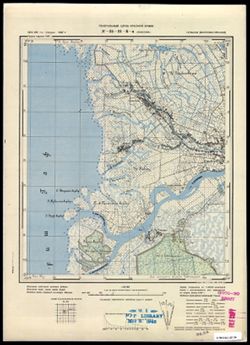
- Topical Subject: Soviet Union, Geographic Subject: Pakalnė, and Topical Subject: Maps
- Publisher:
- Генеральный штаб Красной Армии
- Language:
- Russian
- Date Created:
- 1940
- Identifier:
- VAC9619-003593
- Genre:
- Military Maps and Topographic Maps
- Geographic Location:
- Coordinates: 55.25, 21.25, 55.333, 21.375
- Related URL:
- Catalog URL: https://iucat.iu.edu/catalog/14701157 and Download GeoTIFF: https://drive.google.com/file/d/1frCC6yNDE5XBgN-qoYkrHDNUdIGiIp4Q/view?usp=sharing
- Abstract:
- Modern area represented: Pakalnė, Lithuania
- Call Number:
- G7063.K2 s25 .S6 sheet N-34-31-B-a
- City:
- Покаллна (Pokallna)
- Copyright Holder:
- No Copyright - United States
- Country:
- Германия (Восточная Пруссия) (Germany (East Prussia))
- Physical Description:
- Scale: 1:25,000
- Persistent URL:
- http://purl.dlib.indiana.edu/iudl/images/VAC9619/VAC9619-003593
- Provenance:
- M. I. Map Library
-
- Description:
- 1896
- Subject:
- Topical Subject: Soviet Union, Geographic Subject: Katowice, and Topical Subject: Maps
- Publisher:
- Генеральный штаб Красной Армии
- Language:
- Russian
- Date Created:
- 1940
- Identifier:
- VAC9619-002862
- Genre:
- Topographic Maps and Military Maps
- Geographic Location:
- Coordinates: 50, 19, 50.333, 19.5
- Related URL:
- Catalog URL: https://iucat.iu.edu/catalog/5020129 and Download GeoTIFF: https://drive.google.com/file/d/1jVwnEnut9hOzj9dvqs5LRp2cJarooOxx/view?usp=sharing
- Abstract:
- Modern area represented: Katowice, Silesian province, Poland
- Call Number:
- G7000 s100 .S7 sheet M-34-63
- City:
- Каттовиц (Kattowitz)
- Copyright Holder:
- No Copyright - United States
- Country:
- Германия (Germany)
- State/Province:
- Область государственных интересов Германии (Region of German state interests)
- Physical Description:
- Scale: 1:100,000
- Persistent URL:
- http://purl.dlib.indiana.edu/iudl/images/VAC9619/VAC9619-002862
- Provenance:
- DMA Topographic Center, Army Map Service Library, Library of Congress Geography & Map Division, Geographic Names Branch
-
- Description:
- 1875
- Subject:
- Geographic Subject: Volintiri, Topical Subject: Soviet Union, and Topical Subject: Maps
- Publisher:
- Генеральный штаб РККА
- Language:
- Russian
- Date Created:
- 1940
- Identifier:
- VAC9619-001581
- Genre:
- Topographic Maps and Military Maps
- Geographic Location:
- Coordinates: 46.3333, 29.5, 46.6667, 30
- Related URL:
- Download GeoTIFF: https://drive.google.com/open?id=1yjBpyWEhLGUL0b_IOaIHHjcBR0P7r7Hi and Catalog URL: https://iucat.iu.edu/catalog/5020129
- Abstract:
- Modern area represented: Volintiri, Ștefan Vodă district, Moldova
- Call Number:
- G7000 s100 .S7 sheet L-35-60
- Caption:
- Не подлежит оглашению
- City:
- Волинтирь (Volintiri)
- Copyright Holder:
- No Copyright - United States
- Country:
- СССР (USSR)
- State/Province:
- Украинская ССР (Ukrainian Soviet Socialist Republic), Одесская область (Odessa oblast), Молдавская АССР (Moldavian Autonomous Soviet Socialist Republic), and...
- Physical Description:
- Scale: 1:100,000
- Persistent URL:
- http://purl.dlib.indiana.edu/iudl/images/VAC9619/VAC9619-001581
- Provenance:
- Library of Congress Geography & Map Division, Atlasblatt, DMA Topographic Center, Army Map Service Library, OMAHA
-
- Description:
- 1925
- Subject:
- Topical Subject: Maps, Geographic Subject: Mykolayivka, and Topical Subject: Soviet Union
- Publisher:
- Генеральный штаб Красной Армии
- Language:
- Russian
- Date Created:
- 1940
- Identifier:
- VAC9619-001822
- Genre:
- Topographic Maps and Military Maps
- Geographic Location:
- Coordinates: 47.6667, 34, 48, 34.5
- Related URL:
- Download GeoTIFF: https://drive.google.com/open?id=1U6J1cZ3jBto4nQW05mxJrvbDFQrg0G8o and Catalog URL: https://iucat.iu.edu/catalog/5020129
- Abstract:
- Modern area represented: Mykolayivka, Dnipropetrovsk oblast, Ukraine
- Call Number:
- G7000 s100 .S7 sheet L-36-9
- Caption:
- Для служебного пользования
- City:
- Ново-Николаевка (Novo-Nikolayevka)
- Copyright Holder:
- No Copyright - United States
- Country:
- СССР (USSR)
- State/Province:
- Украинская ССР (Ukrainian Soviet Socialist Republic) and Днепропетровская область (Dnipropetrovsk oblast)
- Physical Description:
- Scale: 1:100,000
- Persistent URL:
- http://purl.dlib.indiana.edu/iudl/images/VAC9619/VAC9619-001822
- Provenance:
- CIA Map Library, Atlasblatt
-
- Description:
- 1938
- Subject:
- Topical Subject: Maps, Topical Subject: Soviet Union, and Geographic Subject: Laukuva
- Publisher:
- Генеральный штаб Красной Армии
- Language:
- Russian
- Date Created:
- 1940
- Identifier:
- VAC9619-003902
- Genre:
- Military Maps and Topographic Maps
- Geographic Location:
- Coordinates: 55.333, 22, 55.667, 22.5
- Related URL:
- Download GeoTIFF: https://drive.google.com/file/d/1yORLtEEj4Glt9k9N2WObjhb-WmDyZkS1/view?usp=sharing and Catalog URL: https://iucat.iu.edu/catalog/5020129
- Abstract:
- Modern area represented: Laukuva, Tauragė county, Lithuania
- Call Number:
- G7000 s100 .S7 sheet N-34-21
- Caption:
- Не подлежит оглашению
- City:
- Лавково (Laukuva)
- Copyright Holder:
- No Copyright - United States
- Country:
- СССР (USSR)
- State/Province:
- Литовская ССР (Lithuanian Soviet Socialist Republic)
- Physical Description:
- Scale: 1:100,000
- Persistent URL:
- http://purl.dlib.indiana.edu/iudl/images/VAC9619/VAC9619-003902
- Provenance:
- DMA Topographic Center, Army Map Service Library, OMAHA
-
- Subject:
- Topical Subject: Soviet Union, Geographic Subject: Lesnoy, and Topical Subject: Maps
- Publisher:
- Генеральный штаб РККА
- Language:
- Russian
- Date Created:
- 1940
- Identifier:
- VAC9619-003588
- Genre:
- Military Maps and Topographic Maps
- Geographic Location:
- Coordinates: 55, 20.5, 55.083, 20.625
- Related URL:
- Catalog URL: https://iucat.iu.edu/catalog/14701157 and Download GeoTIFF: https://drive.google.com/file/d/1iAyyaQlcH3PgnIB6KJJKHwl0iTJ-n3-D/view?usp=sharing
- Abstract:
- Modern area represented: Lesnoy, Kaliningrad oblast, Russia
- Call Number:
- G7063.K2 s25 .S6 sheet N-34-30-C-c
- City:
- Заркау (Zarkau)
- Copyright Holder:
- No Copyright - United States
- Country:
- Германия (Germany) and Восточная Пруссия (East Prussia)
- Physical Description:
- Scale: 1:25,000
- Persistent URL:
- http://purl.dlib.indiana.edu/iudl/images/VAC9619/VAC9619-003588
- Provenance:
- CIA Map Branch -- Received, G000-30
-
- Subject:
- Topical Subject: Soviet Union, Geographic Subject: Rybachiy, and Topical Subject: Maps
- Publisher:
- Генеральный штаб Красной Армии
- Language:
- Russian
- Date Created:
- 1940
- Identifier:
- VAC9619-003590
- Genre:
- Military Maps and Topographic Maps
- Geographic Location:
- Coordinates: 55.083, 20.75, 55.167, 20.875
- Related URL:
- Catalog URL: https://iucat.iu.edu/catalog/14701157 and Download GeoTIFF: https://drive.google.com/file/d/1JlpkAjeRU6ZM55Ej_M3cn9jjp0fom93V/view?usp=sharing
- Abstract:
- Modern area represented: Rybachiy, Kaliningrad oblast, Russia
- Call Number:
- G7063.K2 s25 .S6 sheet N-34-30-D-a
- City:
- Росситтен (Rossitten)
- Copyright Holder:
- No Copyright - United States
- Country:
- Германия (Germany) and Восточная Пруссия (East Prussia)
- Physical Description:
- Scale: 1:25,000
- Persistent URL:
- http://purl.dlib.indiana.edu/iudl/images/VAC9619/VAC9619-003590
- Provenance:
- M. I. Map Library, G000-30, GS, RA
-
- Description:
- 1901
- Subject:
- Topical Subject: Maps, Topical Subject: Soviet Union, and Geographic Subject: Miedzyboz
- Publisher:
- Генеральный штаб РККА
- Language:
- Russian
- Date Created:
- 1940
- Identifier:
- VAC9619-003234
- Genre:
- Topographic Maps and Military Maps
- Geographic Location:
- Coordinates: 49.333, 27, 49.667, 27.5
- Related URL:
- Download GeoTIFF: https://drive.google.com/file/d/1p1tATP-Lqz2OVH19c5nyUCAOE6ldmVrK/view?usp=sharing and Catalog URL: https://iucat.iu.edu/catalog/5020129
- Abstract:
- Modern area represented: Miedzyboz, Khmelnytskyi oblast, Ukraine
- Call Number:
- G7000 s100 .S7 sheet M-35-91
- Caption:
- Не подлежит оглашению
- City:
- Меджибож (Miedzyboz)
- Copyright Holder:
- No Copyright - United States
- Country:
- СССР (USSR)
- State/Province:
- Каменец-Подольская область (Kamianets-Podilskyi oblast) and Украинская ССР (Ukrainian Soviet Socialist Republic)
- Physical Description:
- Scale: 1:100,000
- Persistent URL:
- http://purl.dlib.indiana.edu/iudl/images/VAC9619/VAC9619-003234
- Provenance:
- DMA Topographic Center, Army Map Service Library, OMAHA, Atlasblatt
-
- Description:
- 1885
- Subject:
- Topical Subject: Soviet Union, Geographic Subject: Hajnówka, and Topical Subject: Maps
- Publisher:
- Генеральный штаб РККА
- Language:
- Russian
- Date Created:
- 1940
- Identifier:
- VAC9619-003987
- Genre:
- Topographic Maps and Military Maps
- Geographic Location:
- Coordinates: 52.66667, 23.5, 53.0, 24.0
- Related URL:
- Download GeoTIFF: https://drive.google.com/file/d/1SE_vreXO5YSGYtCvywREYMoZmtRzogV1/view?usp=sharing and Catalog URL: https://iucat.iu.edu/catalog/5020129
- Abstract:
- Modern area represented: Hajnówka, Poland
- Call Number:
- G7000 s100 .S7 sheet N-34-120
- City:
- Гайнувка (Hajnówka)
- Copyright Holder:
- No Copyright - United States
- Country:
- СССР (USSR)
- State/Province:
- Белостокская область (Belastok oblast) and Белорусская ССР (Byelorussian Soviet Socialist Republic)
- Physical Description:
- Scale: 1:100,000
- Persistent URL:
- http://purl.dlib.indiana.edu/iudl/images/VAC9619/VAC9619-003987
- Provenance:
- DMA Topographic Center, Army Map Service Library, OMAHA
