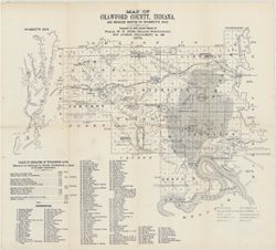
Topical Subject: Mines and mineral resources, Topical Subject: IGS Annual Reports, Geographic Subject: Harrison County (Ind.), Topical Subject: Corydon Capit...
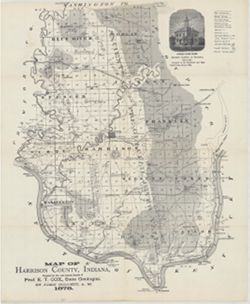
Prepared for the 10th annual report of Prof. E.T. Cox, State Geologist by John Collett, 1878. Relief shown by hachures. Shows cities and towns, railroads, sp...
Call Number:
G4093.H4C5 1878 .C6
Caption:
Imprint: [Indianapolis] : [Geological Survey of Indiana], [1879] and Imprint: [Indianapolis] : [Indianapolis Journal Company, State printers], [1879]
Physical Description:
Dimensions: on sheet 44 x 36 cm and Scale: Approximately 1:130,000
Alternate Identifier:
Alternate ID: 390723IP and Title Control Number: a18363798
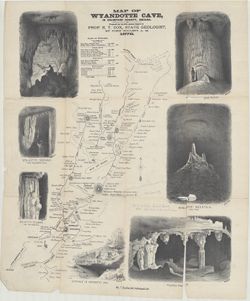
Prepared for the 10th Annual Report of Prof. E. T. Cox, State Geologist, by John Collett, A. M. Relief shown by hachures. Includes sketches of some cave feat...
Call Number:
G4093.C7C23 1878 .C6
Caption:
Imprint: [Indianapolis] : [Indianapolis Journal Company, State printers], [1879] and Imprint: [Indianapolis] : [Geological Survey of Indiana], [1879]
Physical Description:
Dimensions: on sheet 54 x 46 cm and Scale: Approximately 1:11,000
Alternate Identifier:
Alternate ID: 390723IP and Title Control Number: a18372653
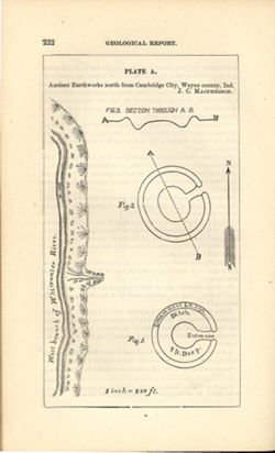
At head of title: Plate A. Relief shown by profile and spot heights. Includes pictorial map of west branch of Whitewater River and three figures showing heig...
Call Number:
G4094.C15E15 1878 .M33
Caption:
Imprint: [Indianapolis] : [Indianapolis Journal Company, State printers], [1879] and Imprint: [Indianapolis] : [Geological Survey of Indiana], [1879]
Physical Description:
Dimensions: on sheet 22 x 13 cm and Scale: Approximately 1:2,400. 1 inch = 200 ft.
Alternate Identifier:
Alternate ID: 390723IP and Title Control Number: a18387638
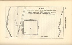
At head of title: Plate C. Shows streams, pits, and earthwork [Indiana Adena Square?] with measurements. Detached from: Eighth, ninth, and tenth annual re...
Call Number:
G4094.N438 1978 .M33
Caption:
Imprint: [Indianapolis] : [Indianapolis Journal Company, State printers], [1879] and Imprint: [Indianapolis] : [Geological Survey of Indiana], [1879]
Physical Description:
Dimensions: on sheet 14 x 21 cm and Scale: Approximately 1:6,000. 1 inch = 500 ft.
Alternate Identifier:
Alternate ID: 390723IP and Title Control Number: a18387636
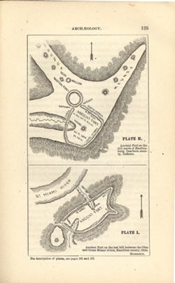
At head of first title: Plate H , At head of second title: Plate I. Relief shown by hachures and spot heights. Shows prehistoric forts [Miami Fort and Oberti...
Call Number:
QE109 .A2
Caption:
Imprint: [Indianapolis] : [Geological Survey of Indiana], [1879] and Imprint: [Indianapolis] : [Indianapolis Journal Company, State printers], [1879]
Physical Description:
Dimensions: 22 x 14 cm and Scale: Scale not given.
Alternate Identifier:
Title Control Number: a18387663 and Alternate ID: 390723IP
Prepared for 10th annual report of Prof. E.T. Cox, State Geologist by John Collett, 1878. Relief shown by hachures. Shows cities and towns, railroads, cavern...
Call Number:
G4093.C7C5 1878 .C6
Caption:
Imprint: [Indianapolis] : [Geological Survey of Indiana], [1879] and Imprint: [Indianapolis] : [Indianapolis Journal Company, State printers], [1879]
Physical Description:
Scale: Approximately 1:125,000 and Dimensions: on sheet 39 x 44 cm
Alternate Identifier:
Title Control Number: a18349479 and Alternate ID: 390723IP
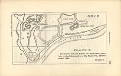
At head of title: Plate G. Relief shown by hachures. Shows prehistoric forts, mounds, waterways, and railroads. "The following map and diagrams are redu...
Call Number:
G4071.E15 1878 .M67
Caption:
Imprint: [Indianapolis] : [Indianapolis Journal Company, State printers], [1879] and Imprint: [Indianapolis] : [Geological Survey of Indiana], [1879]
Physical Description:
Scale: Scale approximately 1:55,000 and Dimensions: on sheet 14 x 21 cm
Alternate Identifier:
Title Control Number: a18387640 and Alternate ID: 390723IP
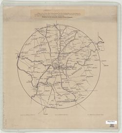
D.J. Lake & Co., published by the Evansville, Indiana Courier Company. Shows portions of Illinois, Indiana, Kentucky, and Tennessee. Includes location ...