
Search Constraints
You searched for:
Publisher
Indiana. Geological Survey
Remove constraint Publisher: Indiana. Geological Survey
« Previous |
1 - 20 of 77
|
Next »
Search Results
-
- Subject:
- Topical Subject: IGS Annual Reports and Geographic Subject: Indiana
- Publisher:
- Indiana. Geological Survey
- Date Created:
- 1875
- Identifier:
- VAC3073-M-01173
- Genre:
- Geological cross-sections
- Related URL:
- Catalog URL: https://iucat.iu.edu/catalog/4022269
- Abstract:
- Lawrence Co.
- Call Number:
- QE109 . A2 1874 map p42
- Caption:
- Imprint: Indianapolis : 1875.
- Physical Description:
- Dimensions: 21 x 34 cm.
- Persistent URL:
- https://purl.dlib.indiana.edu/iudl/images/VAC3073/VAC3073-M-01173
- Provenance:
- 6th Annual Report (1874) / Indiana. Geological Survey.
-
- Subject:
- Geographic Subject: Vanderburgh County (Ind.), Topical Subject: Coal mines and mining, Topical Subject: Mines and mineral resources, Topical Subject: Geology...
- Creator:
- Collett, John, 1828-1899
- Publisher:
- Indiana. Geological Survey
- Date Created:
- 1876
- Identifier:
- VAC3073-M-01146
- Genre:
- Geological maps
- Geographic Location:
- Coordinates: W0874203 W0872658 N0381006 N0374933
- Related URL:
- Catalog URL: https://iucat.iu.edu/catalog/18349316
- Abstract:
- Compiled for the 7th annual report of E.T. Cox, State Geologist , geology by Prof. John Collett, 1875. Relief shown by hachures. Shows cities and towns, rail...
- Call Number:
- G4093.V3C5 1875 .C6
- Caption:
- Imprint: [Indianapolis] : [Geological Survey of Indiana], [1876] and Imprint: [Indianapolis] : [Sentinel Company, printers], [1876]
- Physical Description:
- Scale: Approximately 1:130,000 and Dimensions: on sheet 41 x 31 cm
- Alternate Identifier:
- Alternate ID: 390723IP and Title Control Number: a18349316
- Persistent URL:
- https://purl.dlib.indiana.edu/iudl/images/VAC3073/VAC3073-M-01146
- Provenance:
- 7th Annual Report (1875) / Indiana. Geological Survey.
-
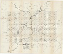
- Subject:
- Topical Subject: Mines and mineral resources, Geographic Subject: Greene County (Ind.), and Topical Subject: IGS Annual Reports
- Creator:
- Levette, G. M. (Gilbert M.)
- Publisher:
- Indiana. Geological Survey
- Date Created:
- 1869
- Identifier:
- VAC3073-M-01449
- Genre:
- Thematic maps
- Geographic Location:
- Coordinates: W0871431 W0864053 N0391018 N0385418
- Related URL:
- Catalog URL: https://iucat.iu.edu/catalog/18189063
- Abstract:
- Shows towns, railroads, coal and iron ore, mills, furnaces, and stone quarries. "For the first annual report of Prof. E.T. Cox, State Geologist." ...
- Call Number:
- G4093.G7H1 1869 .L3
- Caption:
- Imprint: [Indianapolis] : [Alexander M. Conner], [1869]
- Physical Description:
- Dimensions: 61 x 71 cm and Scale: Approximately 1:85,000
- Alternate Identifier:
- Title Control Number: a18189063
- Persistent URL:
- https://purl.dlib.indiana.edu/iudl/images/VAC3073/VAC3073-M-01449
- Provenance:
- 1st Annual Report (1869) / Indiana. Geological Survey
-
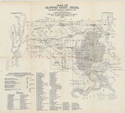
- Subject:
- Topical Subject: IGS Annual Reports, Topical Subject: Coal mines and mining, Geographic Subject: Crawford County (Ind.), Geographic Subject: Wyandotte Cave (...
- Creator:
- Collett, John, 1828-1899
- Publisher:
- Indiana. Geological Survey
- Date Created:
- 1879
- Identifier:
- VAC3073-M-01546
- Genre:
- Thematic maps
- Geographic Location:
- Coordinates: W0863746 W0861445 N0382324 N0380600
- Related URL:
- Catalog URL: https://iucat.iu.edu/catalog/18349479
- Abstract:
- Prepared for 10th annual report of Prof. E.T. Cox, State Geologist by John Collett, 1878. Relief shown by hachures. Shows cities and towns, railroads, cavern...
- Call Number:
- G4093.C7C5 1878 .C6
- Caption:
- Imprint: [Indianapolis] : [Geological Survey of Indiana], [1879] and Imprint: [Indianapolis] : [Indianapolis Journal Company, State printers], [1879]
- Physical Description:
- Scale: Approximately 1:125,000 and Dimensions: on sheet 39 x 44 cm
- Alternate Identifier:
- Title Control Number: a18349479 and Alternate ID: 390723IP
- Persistent URL:
- https://purl.dlib.indiana.edu/iudl/images/VAC3073/VAC3073-M-01546
- Provenance:
- 8th, 9th, and 10th Annual Reports (1876, 1877, 1878) / Indiana. Geological Survey.
-
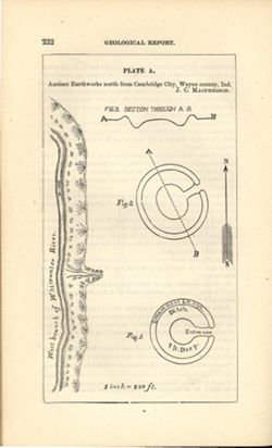
- Subject:
- Geographic Subject: Cambridge City (Ind.), Topical Subject: Henges, and Topical Subject: IGS Annual Reports
- Creator:
- Macpherson, J. C. (John C.)
- Publisher:
- Indiana. Geological Survey
- Date Created:
- 1879
- Identifier:
- VAC3073-M-01551
- Genre:
- Pictorial maps
- Geographic Location:
- Coordinates: W0851016 W0851004 N0395012 N0395001
- Related URL:
- Catalog URL: https://iucat.iu.edu/catalog/18387638
- Abstract:
- At head of title: Plate A. Relief shown by profile and spot heights. Includes pictorial map of west branch of Whitewater River and three figures showing heig...
- Call Number:
- G4094.C15E15 1878 .M33
- Caption:
- Imprint: [Indianapolis] : [Indianapolis Journal Company, State printers], [1879] and Imprint: [Indianapolis] : [Geological Survey of Indiana], [1879]
- Physical Description:
- Dimensions: on sheet 22 x 13 cm and Scale: Approximately 1:2,400. 1 inch = 200 ft.
- Alternate Identifier:
- Alternate ID: 390723IP and Title Control Number: a18387638
- Persistent URL:
- https://purl.dlib.indiana.edu/iudl/images/VAC3073/VAC3073-M-01551
- Provenance:
- 8th, 9th, and 10th Annual Reports (1876, 1877, 1878) / Indiana. Geological Survey.
-
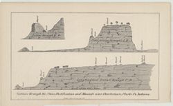
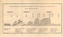
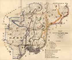
- Subject:
- Topical Subject: Stone walls, Geographic Subject: Clark County (Ind.), Topical Subject: Mounds, and Topical Subject: Fortification
- Publisher:
- Indiana. Geological Survey
- Date Created:
- 1873
- Identifier:
- VAC3073-M-01543
- Genre:
- Geological cross-sections and Pictorial maps
- Geographic Location:
- Coordinates: W0853723 W0853635 N0382605 N0382513
- Related URL:
- Catalog URL: https://iucat.iu.edu/catalog/18318650
- Abstract:
- 3 sections on 1 sheet. Relief shown by profile. Detached from: Geology report. In Fifth annual report of the Geological Survey of Indiana, made in the yea...
- Call Number:
- G4093.C4R4 1873 .S43
- Caption:
- Imprint: [Indianapolis] : [Geological Survey of Indiana], [1874] and Imprint: [Indianapolis] : [Sentinel Co., printers], [1874]
- Physical Description:
- Scale: Scale not given. and Dimensions: on sheet 14 x 22 cm
- Alternate Identifier:
- Title Control Number: a18318650 and Alternate ID: 390723IP
- Persistent URL:
- https://purl.dlib.indiana.edu/iudl/images/VAC3073/VAC3073-M-01543
- Provenance:
- 5th Annual Report (1873) / Indiana. Geological Survey.
-
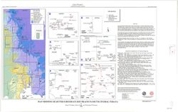
- Subject:
- Topical Subject: Subsurface drainage, Topical Subject: Groundwater, Geographic Subject: Indiana, and Topical Subject: Pollution
- Creator:
- Frushour, Samuel S.
- Publisher:
- Indiana. Geological Survey
- Date Created:
- 2000
- Identifier:
- VAC3073-M-00844
- Genre:
- Thematic maps
- Geographic Location:
- Coordinates: W0865700 W0855900 N0393800 N0375400
- Related URL:
- Catalog URL: https://iucat.iu.edu/catalog/4898418
- Abstract:
- Digital cartogrpahy by Kimberly H. Sowder." Includes index map and text: Abstract and "Sources of subsurface dye trace information."
- Call Number:
- G4091 .C34 2000 .F7
- Caption:
- Imprint: Bloomington, Ind. : Indiana Geological Survey, 2000.
- Physical Description:
- Dimensions: 19 x 19 cm or smaller, on sheet 58 x 92 cm and Scale: 1:500,000
- Alternate Identifier:
- Title Control Number: a4898418
- Persistent URL:
- https://purl.dlib.indiana.edu/iudl/images/VAC3073/VAC3073-M-00844
-
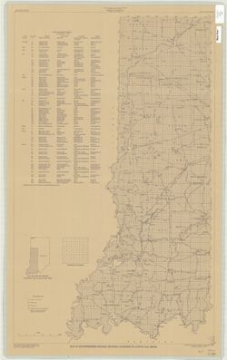
- Subject:
- Geographic Subject: Warren County (Ind.), Topical Subject: Coal mines and mining, Geographic Subject: Vermillion County (Ind.), and Geographic Subject: Fount...
- Creator:
- Hutchison, Harold C. (Harold Christy), 1925-
- Publisher:
- Indiana. Geological Survey
- Date Created:
- 1961
- Identifier:
- VAC3073-M-00418
- Genre:
- Mine maps
- Geographic Location:
- Coordinates: W0873200 W0870533 N0402800 N0395645
- Related URL:
- Catalog URL: https://iucat.iu.edu/catalog/4898738
- Abstract:
- "Preliminary coal map no. 9"--Margin. Includes 1 ancillary map, 1 diagram showing township enumeration, 1 index map, 1 stratigraphic column, and 1 ...
- Call Number:
- G4093.F6H9 1961 .H88
- Caption:
- Imprint: Bloomington : Indiana Dept. of Conservation, Geological Survey, 1961.
- Physical Description:
- Scale: Scales differ. and Dimensions: 61 x 72 cm
- Alternate Identifier:
- Title Control Number: a4898738
- Persistent URL:
- https://purl.dlib.indiana.edu/iudl/images/VAC3073/VAC3073-M-00418
-
- Subject:
- Topical Subject: Geology, Geographic Subject: Clark County (Ind.), Topical Subject: Mines and mineral resources, Geographic Subject: Floyd County (Ind.), and...
- Creator:
- Cox, E. T. (Edward Travers), 1821-1907 and Borden, W. W. (William Wesley), 1823-1906
- Publisher:
- Indiana. Geological Survey
- Date Created:
- 1874
- Identifier:
- VAC3073-M-01155
- Genre:
- Geological maps
- Geographic Location:
- Coordinates: W0860258 W0852426 N0383636 N0380900
- Related URL:
- Catalog URL: https://iucat.iu.edu/catalog/18318611
- Abstract:
- Prepared for the 5th annual report of Prof. E.T. Cox, State Geologist, 1873 , geology by W.W. Borden. Relief shown by hachures. Shows cities and towns, railr...
- Call Number:
- G4093.C4C5 1873 .B6
- Caption:
- Imprint: [Indianapolis] : [Geological Survey of Indiana], [1874] and Imprint: [Indianapolis] : [Sentinel Co., printers], [1874]
- Physical Description:
- Dimensions: on sheet 41 x 49 cm and Scale: Approximately 1:130,000
- Alternate Identifier:
- Alternate ID: 390723IP and Title Control Number: a18318611
- Persistent URL:
- https://purl.dlib.indiana.edu/iudl/images/VAC3073/VAC3073-M-01155
- Provenance:
- 5th Annual Report (1873) / Indiana. Geological Survey.
-
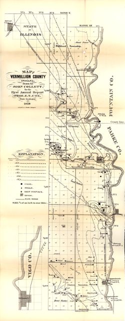
- Subject:
- Topical Subject: IGS Annual Reports, Topical Subject: Coal mines and mining, Topical Subject: Lumber trade, Geographic Subject: Vigo County (Ind.), Topical S...
- Creator:
- Collett, John, 1828-1899
- Publisher:
- Indiana. Geological Survey
- Date Created:
- 1869
- Identifier:
- VAC3073-M-01158
- Genre:
- Geological maps
- Geographic Location:
- Coordinates: W0873159 W0872113 N0400854 N0393626
- Related URL:
- Catalog URL: https://iucat.iu.edu/catalog/16799192
- Abstract:
- Drawn by John Collett for the 1st annual report of Prof. E.T. Cox, State Geologist, 1869 , lith. by W & J. Braden. Shows towns, railroads, coal, mills...
- Call Number:
- G4093.V4 1869 .C6
- Caption:
- Imprint: [Indianapolis] : [Alexander H. Conner, State Printer], [1869] and Imprint: [Indianapolis] : [Geological Survey of Indiana], [1869]
- Physical Description:
- Dimensions: on sheet 77 x 32 cm and Scale: Approximately 1:85,000. 3/4 of an inch to one mile
- Alternate Identifier:
- Title Control Number: a16799192 and Alternate ID: 390720IP
- Persistent URL:
- https://purl.dlib.indiana.edu/iudl/images/VAC3073/VAC3073-M-01158
- Provenance:
- 1st Annual Report (1869) / Indiana. Geological Survey
-
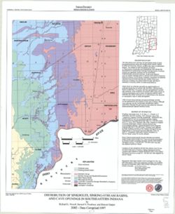
- Subject:
- Topical Subject: Caves, Geographic Subject: Indiana, Topical Subject: Springs, Topical Subject: Sinkholes, and Topical Subject: Karst
- Creator:
- Powell, Richard L.
- Publisher:
- Indiana. Geological Survey
- Date Created:
- 2002
- Identifier:
- VAC3073-M-00135
- Genre:
- Geological maps
- Geographic Location:
- Coordinates: W0870002 W0854608 N0394722 N0375826
- Related URL:
- Catalog URL: https://iucat.iu.edu/catalog/5325676
- Abstract:
- "This map data was compiled in 1997 from information available at the time, but was unpublished until until 2002, the map does not reflect any changes i...
- Call Number:
- G4091.C28 1997 .P69
- Caption:
- Imprint: [Bloomington, Ind.] : Indiana Geological Survey, 2002.
- Physical Description:
- Scale: 1:250,000 and Dimensions: 82 x 42 cm
- Alternate Identifier:
- Title Control Number: a5325676
- Persistent URL:
- https://purl.dlib.indiana.edu/iudl/images/VAC3073/VAC3073-M-00135
-
- Subject:
- Topical Subject: Coal mines and mining and Geographic Subject: Indiana
- Creator:
- Hutchison, Harold C. (Harold Christy), 1925-
- Publisher:
- Indiana. Geological Survey
- Date Created:
- 1974
- Identifier:
- VAC3073-M-00711
- Genre:
- Thematic maps and Mine maps
- Geographic Location:
- Coordinates: W0880100 W0862800 N0403900 N0374500
- Related URL:
- Catalog URL: https://iucat.iu.edu/catalog/5046466
- Abstract:
- Blue line print. "Base modified from Indiana Department of Conservation, Geological Survey. Base map of portion of western Indiana, 1951." Includes...
- Call Number:
- G4091 .H9 1974 .H8
- Caption:
- Imprint: [Bloomington, Ind.] : Indiana Dept. of Conservation, Geological Survey, [1974]
- Physical Description:
- Scale: 1:325,000 and Dimensions: 88 x 54 cm
- Alternate Identifier:
- Title Control Number: a5046466
- Persistent URL:
- https://purl.dlib.indiana.edu/iudl/images/VAC3073/VAC3073-M-00711
-
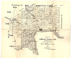
- Subject:
- Topical Subject: IGS Annual Reports, Topical Subject: Real property, Geographic Subject: Jefferson County (Ind.), and Topical Subject: Landowners
- Creator:
- Borden, W. W. (William Wesley), 1823-1906
- Publisher:
- Indiana. Geological Survey
- Date Created:
- 1875
- Identifier:
- VAC3073-M-01172
- Genre:
- Cadastral maps
- Geographic Location:
- Coordinates: W0853944 W0851048 N0385447 N0383436
- Related URL:
- Catalog URL: https://iucat.iu.edu/catalog/18318691
- Abstract:
- Prepared for the sixth annual report of E.T. Cox, State Geologist, geology by W.W. Borden. Relief shown by hachures. Shows cities and towns, railroads, and l...
- Call Number:
- G4093.J5C5 1874 .B6
- Caption:
- Imprint: [Indianapolis, Indiana] : [Sentinel Co., printers], [1875] and Imprint: [Indianapolis] : [Geological Survey of Indiana], [1875]
- Physical Description:
- Dimensions: 40 x 35 cm, on sheet 39 x 47 cm and Scale: Approximately 1:130,000
- Alternate Identifier:
- Alternate ID: 390723IP and Title Control Number: a18318691
- Persistent URL:
- https://purl.dlib.indiana.edu/iudl/images/VAC3073/VAC3073-M-01172
- Provenance:
- 6th Annual Report (1874) / Indiana. Geological Survey.
-
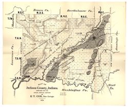
- Subject:
- Geographic Subject: Jackson County (Ind.), Topical Subject: Geology, and Topical Subject: IGS Annual Reports
- Creator:
- Cox, E. T. (Edward Travers), 1821-1907
- Publisher:
- Indiana. Geological Survey
- Date Created:
- 1875
- Identifier:
- VAC3073-M-01177
- Genre:
- Geological maps
- Geographic Location:
- Coordinates: W0861905 W0854741 N0390414 N0384329
- Related URL:
- Catalog URL: https://iucat.iu.edu/catalog/18318685
- Abstract:
- Prepared for the sixth annual report of E[.]T. Cox, State Geologist, 1874. Relief shown by hachures. Shows cities and towns, railroads, geology of the region...
- Call Number:
- G4093.J2C5 1874 .C6
- Caption:
- Imprint: [Indianapolis] : [Geological Survey of Indiana], [1875] and Imprint: [Indianapolis] : [Sentinel Co., printers], [1875]
- Physical Description:
- Scale: Approximately 1:130,000 and Dimensions: on sheet 40 x 47 cm
- Alternate Identifier:
- Title Control Number: a18318685 and Alternate ID: 390723IP
- Persistent URL:
- https://purl.dlib.indiana.edu/iudl/images/VAC3073/VAC3073-M-01177
- Provenance:
- 6th Annual Report (1874) / Indiana. Geological Survey.
-
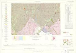
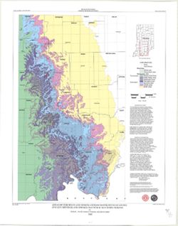
- Subject:
- Geographic Subject: Indiana, Topical Subject: Geology, Stratigraphic, Geographic Subject: Ohio, and Topical Subject: Geology
- Creator:
- Schneider, Allan F. (Allan Frank), 1926-, Gooding, Ansel Miller, Forsyth, Jane L. (Jane Louise), 1921-, Gray, Henry Hamilton, 1922-, and Indiana. Geological ...
- Publisher:
- Indiana. Geological Survey
- Date Created:
- 1972
- Identifier:
- VAC3073-M-01245
- Genre:
- Geological maps, Geological cross-sections, and Quadrangle maps
- Geographic Location:
- Coordinates: W0860000 W0840000 N0400000 N0390000
- Related URL:
- Catalog URL: https://iucat.iu.edu/catalog/16799790
- Abstract:
- By Henry H. Gray, Jane L. Forsyth, Allan F. Schneider, and Ansel M. Gooding. Transverse Mercator projection. "Base map modified from Army Map Service, M...
- Call Number:
- G4091 .C5 1972 .G455
- Caption:
- Imprint: [Bloomington, Ind.] : Indiana Geological Survey, 1972
- Physical Description:
- Dimensions: 73 x 66 cm and Scale: 1:250,000
- Alternate Identifier:
- Title Control Number: a16799790
- Persistent URL:
- https://purl.dlib.indiana.edu/iudl/images/VAC3073/VAC3073-M-01245
- Provenance:
- Indiana. Geological Survey. Regional geologic map , no. 7.
-
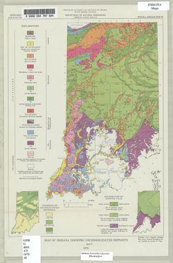
- Subject:
- Topical Subject: Sediments (Geology), Topical Subject: Geology, and Geographic Subject: Indiana
- Creator:
- Indiana. Geological Survey
- Publisher:
- Indiana. Geological Survey
- Date Created:
- 1979
- Identifier:
- VAC3073-M-00675
- Genre:
- Geological maps
- Geographic Location:
- Coordinates: W0880500 W0844700 N0414500 N0374600
- Related URL:
- Catalog URL: https://iucat.iu.edu/catalog/4459811
- Abstract:
- "Modified from Regional Geologic Map Series, Indiana Geological Survey." Includes insets of "Thickness of unconsolidated materials" and &...
- Call Number:
- G4091 .C5 1979 .I5
- Caption:
- Imprint: [Bloomington, Ind.] : The Survey, 1979.
- Physical Description:
- Dimensions: 31 x 22 cm and Scale: 1:1,900,000
- Alternate Identifier:
- Title Control Number: a4459811
- Persistent URL:
- https://purl.dlib.indiana.edu/iudl/images/VAC3073/VAC3073-M-00675
-
- Subject:
- Topical Subject: Karst, Topical Subject: Sinkholes, Geographic Subject: Indiana, and Topical Subject: Caves
- Creator:
- Powell, Richard L.
- Publisher:
- Indiana. Geological Survey
- Date Created:
- 2002
- Identifier:
- VAC3073-M-00789
- Genre:
- Geological maps
- Geographic Location:
- Coordinates: W0854940 W0845820 N0392712 N0384033
- Related URL:
- Catalog URL: https://iucat.iu.edu/catalog/5325528
- Abstract:
- "This map data was compiled in 1997 from information available at the time, but was unpublished until until 2002, the map does not reflect any changes i...
- Call Number:
- G4091.C28 1997 .P694
- Caption:
- Imprint: [Bloomington, Ind.] : Indiana Geological Survey, 2002.
- Physical Description:
- Dimensions: 54 x 49 cm and Scale: 1:250,000
- Alternate Identifier:
- Title Control Number: a5325528
- Persistent URL:
- https://purl.dlib.indiana.edu/iudl/images/VAC3073/VAC3073-M-00789
-
- Subject:
- Geographic Subject: Indiana and Topical Subject: Geology
- Creator:
- Patton, John B. (John Barratt), 1915-
- Publisher:
- Indiana. Geological Survey
- Date Created:
- 1951
- Identifier:
- VAC3073-M-00349
- Genre:
- Geological maps
- Geographic Location:
- Coordinates: W0873622 W0844704 N0400224 N0374618
- Related URL:
- Catalog URL: https://iucat.iu.edu/catalog/6232196
- Abstract:
- Blue line. "Not for publication for correspondence use only"-- Upper margin.
- Call Number:
- G4091.C5 1951 .P38
- Caption:
- Imprint: [Bloomington, Ind.] : Indiana Dept. of Conservation, Geological Survey, 1951.
- Physical Description:
- Dimensions: 20 x 26 cm and Scale: Approximately 1:1,500,000
- Alternate Identifier:
- Title Control Number: a6232196
- Persistent URL:
- https://purl.dlib.indiana.edu/iudl/images/VAC3073/VAC3073-M-00349
-
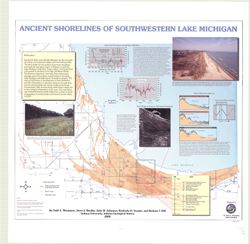
- Subject:
- Geographic Subject: Porter County (Ind.), Geographic Subject: Indiana, Geographic Subject: Michigan, Lake, Coast (Ind.), Topical Subject: Lakes, Topical Subj...
- Creator:
- Thompson, Todd A. (Todd Alan), 1959-
- Publisher:
- Indiana. Geological Survey
- Date Created:
- 2000
- Identifier:
- VAC3073-M-00193
- Genre:
- Thematic maps
- Geographic Location:
- Coordinates: W0873136 W0871307 N0414539 N0410943
- Related URL:
- Catalog URL: https://iucat.iu.edu/catalog/4898581
- Abstract:
- Includes illustrations, text, graphs showing "Lake-level fluctuations over the past 4,700 years" and a timeline showing historical events since 116...
- Call Number:
- G4093 .L3C2 2000 .T486
- Caption:
- Imprint: [Bloomington, Ind.] : Indiana University, Indiana Geological Survey, 2000.
- Physical Description:
- Dimensions: 76 x 87 cm and Scale: 1:59,000
- Alternate Identifier:
- Title Control Number: a4898581
- Persistent URL:
- https://purl.dlib.indiana.edu/iudl/images/VAC3073/VAC3073-M-00193
-
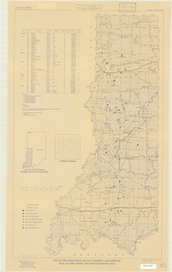
- Subject:
- Topical Subject: Coal preparation plants and Geographic Subject: Indiana
- Creator:
- Eggert, Donald L.
- Publisher:
- Indiana. Geological Survey
- Date Created:
- 1979
- Identifier:
- VAC3073-M-00195
- Genre:
- Mine maps and Thematic maps
- Geographic Location:
- Coordinates: W0880700 W0844500 N0414500 N0375200
- Related URL:
- Catalog URL: https://iucat.iu.edu/catalog/5304756
- Abstract:
- "December 1979".
- Call Number:
- G4091.H9 1979 .E34
- Caption:
- Imprint: [Bloomington, Ind.]: Indiana Geological Survey, 1979.
- Physical Description:
- Dimensions: 67 x 41 cm and Scale: Approximately 1:380,000
- Alternate Identifier:
- Title Control Number: a5304756
- Persistent URL:
- https://purl.dlib.indiana.edu/iudl/images/VAC3073/VAC3073-M-00195

- « Previous
- Next »
- 1
- 2
- 3
- 4