
Search Constraints
You searched for:
State/Province
Белорусская ССР (Byelorussian Soviet Socialist Republic)
Remove constraint State/Province: Белорусская ССР (Byelorussian Soviet Socialist Republic)
« Previous |
1 - 100 of 596
|
Next »
Search Results
-
- Description:
- 1929
- Subject:
- Geographic Subject: Сорокошичі (Sorokoshychi), Topical Subject: Soviet Union, and Topical Subject: Maps
- Publisher:
- Управление военных топографов
- Language:
- Russian
- Identifier:
- VAC9619-000930
- Genre:
- Topographic Maps and Military Maps
- Geographic Location:
- Coordinates: 51.1667, 30.5, 51.3333, 30.75
- Related URL:
- Download GeoTIFF: https://drive.google.com/open?id=1dTQI6Wq1uMK_ewD7h-fEbMTxO0mu3xLH and Catalog URL: http://iucat.iu.edu/catalog/5020131
- Abstract:
- Modern area represented: Сорокошичі (Sorokoshychi), Chernihiv oblast, Ukraine
- Call Number:
- G7000 s50 .S68 sheet M-36-26-A
- Caption:
- Не подлежит оглашению
- City:
- Cорокошичи (Sorokoshichi)
- Copyright Holder:
- No Copyright - United States
- Country:
- СССР (USSR)
- State/Province:
- Украинская ССР (Ukrainian Soviet Socialist Republic) and Белорусская ССР (Byelorussian Soviet Socialist Republic)
- Physical Description:
- Scale: 1:50,000
- Persistent URL:
- http://purl.dlib.indiana.edu/iudl/images/VAC9619/VAC9619-000930
- Provenance:
- DMA Topographic Center, Army Map Service Library, Library of Congress Geography & Map Division
-
- Description:
- 1929
- Subject:
- Topical Subject: Maps, Geographic Subject: Любеч (Lyubech), and Topical Subject: Soviet Union
- Publisher:
- Военно-топографическое управление
- Language:
- Russian
- Identifier:
- VAC9619-000898
- Genre:
- Military Maps and Topographic Maps
- Geographic Location:
- Coordinates: 51.6667, 30.5, 51.8333, 30.75
- Related URL:
- Download GeoTIFF: https://drive.google.com/open?id=16_bYMDreI2liy-TsGZR8MnNe9VR6tNfZ and Catalog URL: http://iucat.iu.edu/catalog/5020131
- Abstract:
- Modern area represented: Любеч (Lyubech), Chernihiv Oblast, Ukraine
- Call Number:
- G7000 s50 .S68 sheet M-36-2-C
- Caption:
- Captured map and Секретно
- City:
- Любечь (Lyubech')
- Copyright Holder:
- No Copyright - United States
- Country:
- СССР (USSR)
- State/Province:
- Белорусская ССР (Byelorussian Soviet Socialist Republic), Гомельский округ (Homyel district), Черниговский округ (Chernihiv district), and Украинская ССР (Uk...
- Physical Description:
- Scale: 1:50,000
- Persistent URL:
- http://purl.dlib.indiana.edu/iudl/images/VAC9619/VAC9619-000898
- Provenance:
- DMA Topographic Center, Army Map Service Library, Library of Congress Geography & Map Division
-
- Description:
- 1929
- Subject:
- Topical Subject: Maps, Geographic Subject: Бывалькі (Byval'ki), and Topical Subject: Soviet Union
- Publisher:
- Военно-топографическое управление
- Language:
- Russian
- Identifier:
- VAC9619-000896
- Genre:
- Topographic Maps and Military Maps
- Geographic Location:
- Coordinates: 51.8333, 30.5, 52, 30.75
- Related URL:
- Catalog URL: http://iucat.iu.edu/catalog/5020131 and Download GeoTIFF: https://drive.google.com/open?id=1f_JvsrXOTMr7mlxgvEAdr_bs77ptv1_U
- Abstract:
- Modern area represented: Бывалькі (Byval'ki), Homyel' oblast, Belarus
- Call Number:
- G7000 s50 .S68 sheet M-36-2-A
- Caption:
- Не подлежит оглашению
- City:
- Бывалки (Byvalki)
- Copyright Holder:
- No Copyright - United States
- Country:
- СССР (USSR)
- State/Province:
- Украинская ССР (Ukrainian Soviet Socialist Republic) and Белорусская ССР (Byelorussian Soviet Socialist Republic)
- Physical Description:
- Scale: 1:50,000
- Persistent URL:
- http://purl.dlib.indiana.edu/iudl/images/VAC9619/VAC9619-000896
- Provenance:
- DMA Topographic Center, Army Map Service Library, OMAHA, Library of Congress Geography & Map Division
-
- Description:
- 1929
- Subject:
- Geographic Subject: Камарын (Kamaryn), Topical Subject: Maps, and Topical Subject: Soviet Union
- Publisher:
- Управление военных топографов
- Language:
- Russian
- Identifier:
- VAC9619-000921
- Genre:
- Military Maps and Topographic Maps
- Geographic Location:
- Coordinates: 51.3333, 30.5, 51.5, 30.75
- Related URL:
- Download GeoTIFF: https://drive.google.com/open?id=1bVHasMT7n_AHd38PSofRBgyRWwlYxOMS and Catalog URL: http://iucat.iu.edu/catalog/5020131
- Abstract:
- Modern area represented: Камарын (Kamaryn), Homyel' oblast, Belarus
- Call Number:
- G7000 s50 .S68 sheet M-36-14-C
- Caption:
- Captured map and Не подлежит оглашению
- City:
- Комарин (Komarin)
- Copyright Holder:
- No Copyright - United States
- Country:
- СССР (USSR)
- State/Province:
- Белорусская ССР (Byelorussian Soviet Socialist Republic) and Украинская ССР (Ukrainian Soviet Socialist Republic)
- Physical Description:
- Scale: 1:50,000
- Persistent URL:
- http://purl.dlib.indiana.edu/iudl/images/VAC9619/VAC9619-000921
- Provenance:
- DMA Topographic Center, Army Map Service Library, Library of Congress Geography & Map Division
-
- Description:
- 1931
- Subject:
- Geographic Subject: Новошепеличі (Novoshepelychi), Topical Subject: Maps, and Topical Subject: Soviet Union
- Publisher:
- Управление военных топографов
- Language:
- Russian
- Identifier:
- VAC9619-000919
- Genre:
- Topographic Maps and Military Maps
- Geographic Location:
- Coordinates: 51.3333, 30, 51.5, 30.25
- Related URL:
- Catalog URL: http://iucat.iu.edu/catalog/5020131 and Download GeoTIFF: https://drive.google.com/open?id=1uTEQWRpIprvx9jp6GWK-vYSgij-bIyS4
- Abstract:
- Modern area represented: Новошепеличі (Novoshepelychi), Kyiv Oblast, Ukraine
- Call Number:
- G7000 s50 .S68 sheet M-36-13-C
- Caption:
- Не подлежит оглашению
- City:
- Новые Шепеличи
- Copyright Holder:
- No Copyright - United States
- Country:
- СССР (USSR)
- State/Province:
- Белорусская ССР (Byelorussian Soviet Socialist Republic) and Украинская ССР (Ukrainian Soviet Socialist Republic)
- Physical Description:
- Scale: 1:50,000
- Persistent URL:
- http://purl.dlib.indiana.edu/iudl/images/VAC9619/VAC9619-000919
- Provenance:
- DMA Topographic Center, Army Map Service Library, OMAHA, Library of Congress Geography & Map Division
-
- Subject:
- Geographic Subject: Савічы (Savichy), Topical Subject: Soviet Union, and Topical Subject: Maps
- Publisher:
- Управление военных топографов
- Language:
- Russian
- Identifier:
- VAC9619-000915
- Genre:
- Military Maps and Topographic Maps
- Geographic Location:
- Coordinates: 51.5, 30.25, 51.6667, 30.5
- Related URL:
- Catalog URL: http://iucat.iu.edu/catalog/5020131 and Download GeoTIFF: https://drive.google.com/open?id=1FtDnyPGMSCBKzSKDgR72MJxNvsOGXkXF
- Abstract:
- Modern area represented: Савічы (Savichy), Homyel' Oblast, Belarus
- Call Number:
- G7000 s50 .S68 sheet M-36-13-B
- Caption:
- Не подлежит оглашению
- City:
- Савичи (Savichi)
- Copyright Holder:
- No Copyright - United States
- Country:
- СССР (USSR)
- State/Province:
- Белорусская ССР (Byelorussian Soviet Socialist Republic)
- Physical Description:
- Scale: 1:50,000
- Persistent URL:
- http://purl.dlib.indiana.edu/iudl/images/VAC9619/VAC9619-000915
- Provenance:
- DMA Topographic Center, Army Map Service Library, Library of Congress Geography & Map Division
-
- Description:
- 1929
- Subject:
- Topical Subject: Soviet Union, Topical Subject: Maps, and Geographic Subject: Асарэвічы (Asarevichy)
- Publisher:
- Военно-топографическое управление
- Language:
- Russian
- Identifier:
- VAC9619-000918
- Genre:
- Topographic Maps and Military Maps
- Geographic Location:
- Coordinates: 51.5, 30.3274, 51.6667, 30.5
- Related URL:
- Catalog URL: http://iucat.iu.edu/catalog/5020131 and Download GeoTIFF: https://drive.google.com/file/d/1pPk0Bg7kOEhNFIqDsY2MxC_Ku3mG-gFv/view?usp=sharing
- Abstract:
- Modern area represented: Асарэвічы (Asarevichy), Homyel' Oblast, Belarus
- Call Number:
- G7000 s50 .S68 sheet M-36-13-B1929
- Caption:
- Captured map and Секретно
- City:
- Асаревичи (Asarevichi)
- Copyright Holder:
- No Copyright - United States
- Country:
- СССР (USSR)
- State/Province:
- Гомельский округ (Homyel district) and Белорусская ССР (Byelorussian Soviet Socialist Republic)
- Physical Description:
- Scale: 1:50,000
- Persistent URL:
- http://purl.dlib.indiana.edu/iudl/images/VAC9619/VAC9619-000918
- Provenance:
- CIA Map Branch -- Received, OMAHA, Library of Congress Geography & Map Division
-
- Description:
- 1931
- Subject:
- Topical Subject: Soviet Union, Geographic Subject: Гомельская область, Geographic Subject: Радзін (Radzin), and Topical Subject: Maps
- Publisher:
- Управление военных топографов
- Language:
- Russian
- Identifier:
- VAC9619-000910
- Genre:
- Military Maps and Topographic Maps
- Geographic Location:
- Coordinates: 51.5, 30, 51.6667, 30.25
- Related URL:
- Download GeoTIFF: https://drive.google.com/open?id=1TgFldpUtWlWDkfXucgyQ22RniXwyiEfR and Catalog URL: http://iucat.iu.edu/catalog/5020131
- Abstract:
- Modern area represented: Радзін (Radzin), Homyel' Oblast, Belarus
- Call Number:
- G7000 s50 .S68 sheet M-36-13-A
- Caption:
- Не подлежит оглашению
- City:
- Старый Радин (Staryy Radin)
- Copyright Holder:
- No Copyright - United States
- Country:
- СССР (USSR)
- State/Province:
- Белорусская ССР (Byelorussian Soviet Socialist Republic) and Украинская ССР (Ukrainian Soviet Socialist Republic)
- Physical Description:
- Scale: 1:50,000
- Persistent URL:
- http://purl.dlib.indiana.edu/iudl/images/VAC9619/VAC9619-000910
- Provenance:
- DMA Topographic Center, Army Map Service Library, OMAHA, Library of Congress Geography & Map Division
-
- Description:
- 1930
- Subject:
- Geographic Subject: Velitin, Topical Subject: Maps, and Topical Subject: Soviet Union
- Publisher:
- Управление военных топографов
- Language:
- Russian
- Date Created:
- 1931
- Identifier:
- VAC9619-000894
- Genre:
- Topographic Maps and Military Maps
- Geographic Location:
- Coordinates: 51.8333, 30, 52, 30.25
- Related URL:
- Download GeoTIFF: https://drive.google.com/open?id=10XslogvoEBnpx6j6XiAIb39Zil6sOvwZ and Catalog URL: http://iucat.iu.edu/catalog/5020131
- Abstract:
- Modern area represented: Velitin, Homyel oblast, Ukraine
- Call Number:
- G7000 s50 .S68 sheet М-36-1-А
- Caption:
- Не подлежит оглашению
- City:
- Велитин (Velitin)
- Copyright Holder:
- No Copyright - United States
- Country:
- СССР (USSR)
- State/Province:
- Белорусская ССР (Byelorussian Soviet Socialist Republic)
- Physical Description:
- Scale: 1:50,000
- Persistent URL:
- http://purl.dlib.indiana.edu/iudl/images/VAC9619/VAC9619-000894
- Provenance:
- DMA Topographic Center, Army Map Service Library, Library of Congress Geography & Map Division
-
- Description:
- 1937
- Subject:
- Topical Subject: Maps, Geographic Subject: Sutoki, and Topical Subject: Soviet Union
- Publisher:
- Генеральный штаб РККА
- Language:
- Russian
- Identifier:
- VAC9619-003221
- Genre:
- Military Maps and Topographic Maps
- Geographic Location:
- Coordinates: 56, 29, 56.333, 29.5
- Related URL:
- Catalog URL: https://iucat.iu.edu/catalog/5020129 and Download GeoTIFF: https://drive.google.com/file/d/1UlSlY4soVUgoZpJ57BGoE2rdKCSjyw-w/view?usp=sharing
- Abstract:
- Modern area represented: Сутоки (Sutoki), Pskovskaya oblast, Russia
- Call Number:
- G7000 s100 .S7 sheet O-35-143
- Caption:
- Captured map and Не подлежит оглашению
- City:
- Сутоки (Sutoki)
- Copyright Holder:
- No Copyright - United States
- Country:
- СССР (USSR)
- State/Province:
- Белорусская ССР (Byelorussian Soviet Socialist Republic), Калининская область (Kalinin oblast), РСФСР (RSFSR), and Витебская область (Vitebsk oblast)
- Physical Description:
- Scale: 1:100,000
- Persistent URL:
- http://purl.dlib.indiana.edu/iudl/images/VAC9619/VAC9619-003221
- Provenance:
- DMA Topographic Center, Army Map Service Library, OMAHA
-
- Description:
- 1937
- Subject:
- Topical Subject: Maps, Geographic Subject: Idritsa, and Topical Subject: Soviet Union
- Publisher:
- Генеральный штаб РККА
- Language:
- Russian
- Identifier:
- VAC9619-003220
- Genre:
- Military Maps and Topographic Maps
- Geographic Location:
- Coordinates: 56, 28.5, 56.333, 29
- Related URL:
- Download GeoTIFF: https://drive.google.com/file/d/1QGjeHN5NpWevuyhhfqebnmkcCOcFj-fx/view?usp=sharing and Catalog URL: https://iucat.iu.edu/catalog/5020129
- Abstract:
- Modern area represented: Идрица (Idritsa), Pskovskaya oblast, Russia
- Call Number:
- G7000 s100 .S7 sheet O-35-142
- Caption:
- Не подлежит оглашению
- City:
- Идрица (Idritsa)
- Copyright Holder:
- No Copyright - United States
- Country:
- СССР (USSR)
- State/Province:
- Белорусская ССР (Byelorussian Soviet Socialist Republic), Витебская область (Vitebsk oblast), Калининская область (Kalinin oblast), and РСФСР (RSFSR)
- Physical Description:
- Scale: 1:100,000
- Persistent URL:
- http://purl.dlib.indiana.edu/iudl/images/VAC9619/VAC9619-003220
- Provenance:
- DMA Topographic Center, Army Map Service Library, OMAHA
-
- Subject:
- Geographic Subject: Sebezh, Topical Subject: Maps, and Topical Subject: Soviet Union
- Publisher:
- Генеральный штаб РККА
- Language:
- Russian
- Identifier:
- VAC9619-003219
- Genre:
- Military Maps and Topographic Maps
- Geographic Location:
- Coordinates: 56, 28, 56.333, 28.5
- Related URL:
- Download GeoTIFF: https://drive.google.com/file/d/1J74zM567DphxbPiNXneGAwuZem--8FZR/view?usp=sharing and Catalog URL: https://iucat.iu.edu/catalog/5020129
- Abstract:
- Modern area represented: Себеж (Sebezh), Pskovskaya oblast, Russia
- Call Number:
- G7000 s100 .S7 sheet O-35-141
- Caption:
- Не подлежит оглашению and Captured map
- City:
- Себеж (Sebezh)
- Copyright Holder:
- No Copyright - United States
- Country:
- Латвия (Latvia) and СССР (USSR)
- State/Province:
- РСФСР (RSFSR), Витебская область (Vitebsk oblast), Калининская область (Kalinin oblast), and Белорусская ССР (Byelorussian Soviet Socialist Republic)
- Physical Description:
- Scale: 1:100,000
- Persistent URL:
- http://purl.dlib.indiana.edu/iudl/images/VAC9619/VAC9619-003219
- Provenance:
- DMA Topographic Center, Army Map Service Library, OMAHA
-
- Subject:
- Topical Subject: Maps, Geographic Subject: Dagda, and Topical Subject: Soviet Union
- Publisher:
- Генеральный штаб РККА
- Language:
- Russian
- Identifier:
- VAC9619-003218
- Genre:
- Military Maps and Topographic Maps
- Geographic Location:
- Coordinates: 56, 27.5, 56.333, 28
- Related URL:
- Download GeoTIFF: https://drive.google.com/file/d/1Eohk0RDJQ4rFPqNs12M05IqYtSnMEJNS/view?usp=sharing and Catalog URL: https://iucat.iu.edu/catalog/5020129
- Abstract:
- Modern area represented: Дагда (Dagda), Latvia
- Call Number:
- G7000 s100 .S7 sheet O-35-140
- Caption:
- Captured map and Не подлежит оглашению
- City:
- Дагда (Dagda)
- Copyright Holder:
- No Copyright - United States
- Country:
- Латвия (Latvia) and СССР (USSR)
- State/Province:
- Белорусская ССР (Byelorussian Soviet Socialist Republic) and Витебская область (Vitebsk oblast)
- Physical Description:
- Scale: 1:100,000
- Persistent URL:
- http://purl.dlib.indiana.edu/iudl/images/VAC9619/VAC9619-003218
- Provenance:
- DMA Topographic Center, Army Map Service Library, OMAHA
-
- Description:
- 1928
- Subject:
- Topical Subject: Maps, Topical Subject: Soviet Union, and Geographic Subject: Sidorovichi
- Publisher:
- Управление военных топографов РККА
- Language:
- Russian
- Identifier:
- VAC9619-001491
- Genre:
- Topographic Maps and Military Maps
- Geographic Location:
- Coordinates: 53, 31, 53.1667, 31.25
- Related URL:
- Download GeoTIFF: https://drive.google.com/open?id=14CtH2oyA5T83uZvToRCwUrheXc4a-Sp8 and Catalog URL: http://iucat.iu.edu/catalog/5020131
- Abstract:
- Modern area represented: Sidorovichi, Homyel oblast, Belarus
- Call Number:
- G7000 s50 .S68 sheet N-36-99-C
- Caption:
- Не подлежит оглашению
- City:
- Сидоровичи (Sidorovichi)
- Copyright Holder:
- No Copyright - United States
- Country:
- СССР (USSR)
- State/Province:
- Белорусская ССР (Byelorussian Soviet Socialist Republic)
- Physical Description:
- Scale: 1:50,000
- Persistent URL:
- http://purl.dlib.indiana.edu/iudl/images/VAC9619/VAC9619-001491
- Provenance:
- DMA Topographic Center, Army Map Service Library, OMAHA, Library of Congress Geography & Map Division
-
- Description:
- 1928
- Subject:
- Topical Subject: Maps, Geographic Subject: Perelazy, and Topical Subject: Soviet Union
- Publisher:
- Военно-топографическое управление
- Language:
- Russian
- Identifier:
- VAC9619-001492
- Genre:
- Military Maps and Topographic Maps
- Geographic Location:
- Coordinates: 53, 31.25, 53.1667, 31.5
- Related URL:
- Download GeoTIFF: https://drive.google.com/open?id=1ENiuALuDhQhhmTPCP9izmCTMfCtZ8nYe and Catalog URL: http://iucat.iu.edu/catalog/5020131
- Abstract:
- Modern area represented: Perelazy, Bryansk oblast, Russia
- Call Number:
- G7000 s50 .S68 sheet N-36-99-D
- Caption:
- Секретно
- City:
- Перелазы (Perelazy)
- Copyright Holder:
- No Copyright - United States
- Country:
- СССР (USSR)
- State/Province:
- РСФСР (RSFSR), Западная область (Western oblast), and Белорусская ССР (Byelorussian Soviet Socialist Republic)
- Physical Description:
- Scale: 1:50,000
- Persistent URL:
- http://purl.dlib.indiana.edu/iudl/images/VAC9619/VAC9619-001492
- Provenance:
- DMA Topographic Center, Army Map Service Library, OMAHA, Library of Congress Geography & Map Division
-
- Description:
- 1928
- Subject:
- Topical Subject: Maps, Geographic Subject: Mkhinichi, and Topical Subject: Soviet Union
- Publisher:
- Военно-топографическое управление
- Language:
- Russian
- Identifier:
- VAC9619-001490
- Genre:
- Topographic Maps and Military Maps
- Geographic Location:
- Coordinates: 53.1667, 31.25, 53.3333, 31.5
- Related URL:
- Download GeoTIFF: https://drive.google.com/open?id=1jQtEydII-8vbaqeMq9G233ulXq_l2Mp- and Catalog URL: http://iucat.iu.edu/catalog/5020131
- Abstract:
- Modern area represented: Mkhinichi, Mogilev, Belarus
- Call Number:
- G7000 s50 .S68 sheet N-36-99-B
- Caption:
- Секретно
- City:
- Мхиничи (Mkhinichi)
- Copyright Holder:
- No Copyright - United States
- Country:
- СССР (USSR)
- State/Province:
- Белорусская ССР (Byelorussian Soviet Socialist Republic)
- Physical Description:
- Scale: 1:50,000
- Persistent URL:
- http://purl.dlib.indiana.edu/iudl/images/VAC9619/VAC9619-001490
- Provenance:
- DMA Topographic Center, Army Map Service Library, OMAHA, Library of Congress Geography & Map Division
-
- Description:
- 1928
- Subject:
- Geographic Subject: Byerazyaki Pyershyya, Topical Subject: Maps, and Topical Subject: Soviet Union
- Publisher:
- Управление военных топографов РККА
- Language:
- Russian
- Identifier:
- VAC9619-001489
- Genre:
- Military Maps and Topographic Maps
- Geographic Location:
- Coordinates: 53.1667, 31, 53.3333, 31.25
- Related URL:
- Download GeoTIFF: https://drive.google.com/open?id=1DipC2Cg7TG5Yl2MoUucSxI-zQTjRu3Xt and Catalog URL: http://iucat.iu.edu/catalog/5020131
- Abstract:
- Modern area represented: Byerazyaki Pyershyya, Mogilev, Belarus
- Call Number:
- G7000 s50 .S68 sheet N-36-99-A
- Caption:
- Не подлежит оглашению
- City:
- Березяки (Berezyaki)
- Copyright Holder:
- No Copyright - United States
- Country:
- СССР (USSR)
- State/Province:
- Белорусская ССР (Byelorussian Soviet Socialist Republic)
- Physical Description:
- Scale: 1:50,000
- Persistent URL:
- http://purl.dlib.indiana.edu/iudl/images/VAC9619/VAC9619-001489
- Provenance:
- Army Map Service Library, Library of Congress Geography & Map Division, OMAHA
-
- Description:
- 1928
- Subject:
- Topical Subject: Maps, Topical Subject: Soviet Union, and Geographic Subject: Krasnapollye
- Publisher:
- Генеральный штаб Красной Армии
- Language:
- Russian
- Date Created:
- 1941
- Identifier:
- VAC9619-001975
- Genre:
- Topographic Maps and Military Maps
- Geographic Location:
- Coordinates: 53, 31, 53.3333, 31.5
- Related URL:
- Catalog URL: https://iucat.iu.edu/catalog/5020129 and Download GeoTIFF: https://drive.google.com/open?id=1Z5dBUoWQLQ-zZh5EGMm6plrHEkU-C9l6
- Abstract:
- Modern area represented: Краснаполле (Krasnapollye), Mogilev district, Belarus
- Call Number:
- G7000 s100 .S7 sheet N-36-99
- Caption:
- Для служебного пользования
- City:
- Краснополье (Krasnopol’ye)
- Copyright Holder:
- No Copyright - United States
- Country:
- СССР (USSR)
- State/Province:
- РСФСР (RSFSR), Орловская область (Oryol oblast), Гомельская область (Homyel oblast), Белорусская ССР (Byelorussian Soviet Socialist Republic), and Могилевска...
- Physical Description:
- Scale: 1:100,000
- Persistent URL:
- http://purl.dlib.indiana.edu/iudl/images/VAC9619/VAC9619-001975
- Provenance:
- DMA Topographic Center, Army Map Service Library, Library of Congress Geography & Map Division
-
- Description:
- 1928
- Subject:
- Geographic Subject: Karma, Topical Subject: Soviet Union, and Topical Subject: Maps
- Publisher:
- Управление военных топографов РККА
- Language:
- Russian
- Identifier:
- VAC9619-001488
- Genre:
- Military Maps and Topographic Maps
- Geographic Location:
- Coordinates: 53, 30.75, 53.1667, 31
- Related URL:
- Catalog URL: http://iucat.iu.edu/catalog/5020131 and Download GeoTIFF: https://drive.google.com/open?id=1auewxECG5RQCc2MxiN6jXOxm43MRlEyj
- Abstract:
- Modern area represented: Karma, Homyel oblast, Belarus
- Call Number:
- G7000 s50 .S68 sheet N-36-98-D
- Caption:
- Не подлежит оглашению
- City:
- Корма (Korma)
- Copyright Holder:
- No Copyright - United States
- Country:
- СССР (USSR)
- State/Province:
- Белорусская ССР (Byelorussian Soviet Socialist Republic)
- Physical Description:
- Scale: 1:50,000
- Persistent URL:
- http://purl.dlib.indiana.edu/iudl/images/VAC9619/VAC9619-001488
- Provenance:
- DMA Topographic Center, Army Map Service Library, OMAHA, Library of Congress Geography & Map Division
-
- Description:
- 1928
- Subject:
- Geographic Subject: Slavnya, Topical Subject: Maps, and Topical Subject: Soviet Union
- Publisher:
- Управление военных топографов
- Language:
- Russian
- Identifier:
- VAC9619-001487
- Genre:
- Military Maps and Topographic Maps
- Geographic Location:
- Coordinates: 53.1667, 30.75, 53.3333, 31
- Related URL:
- Download GeoTIFF: https://drive.google.com/open?id=1lVT-0rzh1ByHE3fXveb63ksjcTc8r32b and Catalog URL: http://iucat.iu.edu/catalog/5020131
- Abstract:
- Modern area represented: Slavnya, Mogilev, Belarus
- Call Number:
- G7000 s50 .S68 sheet N-36-98-B
- Caption:
- Не подлежит оглашению
- City:
- Славня (Slavnya)
- Copyright Holder:
- No Copyright - United States
- Country:
- СССР (USSR)
- State/Province:
- Белорусская ССР (Byelorussian Soviet Socialist Republic)
- Physical Description:
- Scale: 1:50,000
- Persistent URL:
- http://purl.dlib.indiana.edu/iudl/images/VAC9619/VAC9619-001487
- Provenance:
- DMA Topographic Center, Army Map Service Library, OMAHA, Library of Congress Geography & Map Division
-
- Description:
- 1926
- Subject:
- Geographic Subject: Zhuravichy, Topical Subject: Maps, and Topical Subject: Soviet Union
- Publisher:
- Управление военных топографов РККА
- Language:
- Russian
- Identifier:
- VAC9619-001486
- Genre:
- Topographic Maps and Military Maps
- Geographic Location:
- Coordinates: 53.1667, 30.5, 53.3333, 30.75
- Related URL:
- Catalog URL: http://iucat.iu.edu/catalog/5020131 and Download GeoTIFF: https://drive.google.com/open?id=1lUprQCQcIfCsvdXgirNCirw6aNhFuzMO
- Abstract:
- Modern area represented: Zhuravichy, Homyel oblast, Belarus
- Call Number:
- G7000 s50 .S68 sheet N-36-98-A
- Caption:
- Не подлежит оглашению
- City:
- Журавичи (Zhuravichy)
- Copyright Holder:
- No Copyright - United States
- Country:
- СССР (USSR)
- State/Province:
- Белорусская ССР (Byelorussian Soviet Socialist Republic)
- Physical Description:
- Scale: 1:50,000
- Persistent URL:
- http://purl.dlib.indiana.edu/iudl/images/VAC9619/VAC9619-001486
- Provenance:
- Army Map Service Library, Library of Congress Geography & Map Division, OMAHA
-
- Subject:
- Topical Subject: Maps, Geographic Subject: Zhuravichy, and Topical Subject: Soviet Union
- Publisher:
- Генеральный штаб Красной Армии
- Language:
- Russian
- Identifier:
- VAC9619-001974
- Genre:
- Military Maps and Topographic Maps
- Geographic Location:
- Coordinates: 53, 30.5, 53.3333, 31
- Related URL:
- Catalog URL: https://iucat.iu.edu/catalog/5020129 and Download GeoTIFF: https://drive.google.com/open?id=1TCj8XRpeHue8O1TGLMTnnfY8JsIBqX-R
- Abstract:
- Modern area represented: Журавічы (Zhuravichy), Gomel district, Belarus
- Call Number:
- G7000 s100 .S7 sheet N-36-98
- Caption:
- Для служебного пользования
- City:
- Журавичи (Zhuravichi)
- Copyright Holder:
- No Copyright - United States
- Country:
- СССР (USSR)
- State/Province:
- Белорусская ССР (Byelorussian Soviet Socialist Republic)
- Physical Description:
- Scale: 1:100,000
- Persistent URL:
- http://purl.dlib.indiana.edu/iudl/images/VAC9619/VAC9619-001974
- Provenance:
- DMA Topographic Center, Army Map Service Library
-
- Description:
- 1938
- Subject:
- Topical Subject: Soviet Union, Geographic Subject: Rahachow, and Topical Subject: Maps
- Publisher:
- Управление военных топографов РККА
- Language:
- Russian
- Identifier:
- VAC9619-001480
- Genre:
- Military Maps and Topographic Maps
- Geographic Location:
- Coordinates: 53, 30, 53.1667, 30.25
- Related URL:
- Catalog URL: http://iucat.iu.edu/catalog/5020131 and Download GeoTIFF: https://drive.google.com/open?id=1MFbzEarSW1uw7S4tQoMKJtGj4hkW7fHv
- Abstract:
- Modern area represented: Rahachow, Homyel oblast, Belarus
- Call Number:
- G7000 s50 .S68 sheet N-36-97-C
- Caption:
- Не подлежит оглашению
- City:
- Рогачев (Rahachow)
- Copyright Holder:
- No Copyright - United States
- Country:
- СССР (USSR)
- State/Province:
- Белорусская ССР (Byelorussian Soviet Socialist Republic)
- Physical Description:
- Scale: 1:50,000
- Persistent URL:
- http://purl.dlib.indiana.edu/iudl/images/VAC9619/VAC9619-001480
- Provenance:
- Army Map Service Library, Library of Congress Geography & Map Division, OMAHA
-
- Description:
- 1936
- Subject:
- Topical Subject: Soviet Union, Geographic Subject: Zvonets, and Topical Subject: Maps
- Publisher:
- Управление военных топографов РККА
- Language:
- Russian
- Identifier:
- VAC9619-001482
- Genre:
- Military Maps and Topographic Maps
- Geographic Location:
- Coordinates: 53.1667, 30.25, 53.3333, 30.5
- Related URL:
- Download GeoTIFF: https://drive.google.com/open?id=1r2DMZh2mjVq3AyPIe8qc-uOASC2UD_rt and Catalog URL: http://iucat.iu.edu/catalog/5020131
- Abstract:
- Modern area represented: Zvonets, Homyel oblast, Belarus
- Call Number:
- G7000 s50 .S68 sheet N-36-97-B
- Caption:
- Не подлежит оглашению
- City:
- Звонец (Zvonets)
- Copyright Holder:
- No Copyright - United States
- Country:
- СССР (USSR)
- State/Province:
- Белорусская ССР (Byelorussian Soviet Socialist Republic)
- Physical Description:
- Scale: 1:50,000
- Persistent URL:
- http://purl.dlib.indiana.edu/iudl/images/VAC9619/VAC9619-001482
- Provenance:
- DMA Topographic Center, Army Map Service Library, OMAHA, Library of Congress Geography & Map Division
-
- Description:
- 1936
- Subject:
- Topical Subject: Maps, Topical Subject: Soviet Union, and Geographic Subject: Toshchitsa
- Publisher:
- Управление военных топографов РККА
- Language:
- Russian
- Identifier:
- VAC9619-001483
- Genre:
- Topographic Maps and Military Maps
- Geographic Location:
- Coordinates: 53.1667, 30, 53.3333, 30.25
- Related URL:
- Download GeoTIFF: https://drive.google.com/open?id=1_FYtD0RS3xN9iUCIS0n9c-h7tZVOzuti and Catalog URL: http://iucat.iu.edu/catalog/5020131
- Abstract:
- Modern area represented: Toshchitsa, Mogilev, Belarus
- Call Number:
- G7000 s50 .S68 sheet N-36-97-A
- Caption:
- Не подлежит оглашению
- City:
- Тощица (Toshchitsa)
- Copyright Holder:
- No Copyright - United States
- Country:
- СССР (USSR)
- State/Province:
- Белорусская ССР (Byelorussian Soviet Socialist Republic)
- Physical Description:
- Scale: 1:50,000
- Persistent URL:
- http://purl.dlib.indiana.edu/iudl/images/VAC9619/VAC9619-001483
- Provenance:
- Army Map Service Library, Library of Congress Geography & Map Division, OMAHA
-
- Description:
- 1936
- Subject:
- Topical Subject: Soviet Union, Topical Subject: Maps, and Geographic Subject: Rahachow
- Publisher:
- Генеральный штаб РККА
- Language:
- Russian
- Identifier:
- VAC9619-001973
- Genre:
- Topographic Maps and Military Maps
- Geographic Location:
- Coordinates: 53, 30, 53.3333, 30.5
- Related URL:
- Download GeoTIFF: https://drive.google.com/open?id=1bMZ3KFudtv8I-VO8vcIQIBb-6G2k8dHZ and Catalog URL: https://iucat.iu.edu/catalog/5020129
- Abstract:
- Modern area represented: Рагачоў (Rahachow), Gomel district, Belarus
- Call Number:
- G7000 s100 .S7 sheet N-36-97
- Caption:
- Не подлежит оглашению
- City:
- Рогачев (Rahachow)
- Copyright Holder:
- No Copyright - United States
- Country:
- СССР (USSR)
- State/Province:
- Белорусская ССР (Byelorussian Soviet Socialist Republic)
- Physical Description:
- Scale: 1:100,000
- Persistent URL:
- http://purl.dlib.indiana.edu/iudl/images/VAC9619/VAC9619-001973
- Provenance:
- DMA Topographic Center, Army Map Service Library, OMAHA, Library of Congress Geography & Map Division
-
- Description:
- 1936
- Subject:
- Geographic Subject: Gadilovichi, Topical Subject: Maps, and Topical Subject: Soviet Union
- Publisher:
- Управление военных топографов РККА
- Language:
- Russian
- Identifier:
- VAC9619-001485
- Genre:
- Topographic Maps and Military Maps
- Geographic Location:
- Coordinates: 53, 30.25, 53.1667, 30.5
- Related URL:
- Catalog URL: http://iucat.iu.edu/catalog/5020131 and Download GeoTIFF: https://drive.google.com/open?id=1brXddhg0G6bGWPjqapYFWje60ePNOC1r
- Abstract:
- Modern area represented: Gadilovichi, Homyel oblast, Belarus
- Call Number:
- G7000 s50 .S68 sheet N-36-97-D
- Caption:
- Не подлежит оглашению
- City:
- Гадиловичи (Gadilovichi)
- Copyright Holder:
- No Copyright - United States
- Country:
- СССР (USSR)
- State/Province:
- Белорусская ССР (Byelorussian Soviet Socialist Republic)
- Physical Description:
- Scale: 1:50,000
- Persistent URL:
- http://purl.dlib.indiana.edu/iudl/images/VAC9619/VAC9619-001485
- Provenance:
- DMA Topographic Center, Army Map Service Library, OMAHA, Library of Congress Geography & Map Division
-
- Description:
- 1931
- Subject:
- Geographic Subject: Razrytoye, Topical Subject: Maps, and Topical Subject: Soviet Union
- Publisher:
- Управление военных топографов
- Language:
- Russian
- Identifier:
- VAC9619-001450
- Genre:
- Topographic Maps and Military Maps
- Geographic Location:
- Coordinates: 53.3333, 32.75, 53.5, 33
- Related URL:
- Download GeoTIFF: https://drive.google.com/open?id=1Ks2FByvEOj90pyqtFjIQtDkk--6HbR4S and Catalog URL: http://iucat.iu.edu/catalog/5020131
- Abstract:
- Modern area represented: Razrytoye, Bryansk oblast, Russia
- Call Number:
- GM G7000 S50 .S68 N-36-90-Г
- Caption:
- Не подлежит оглашению
- City:
- Разрытое (Razrytoye)
- Copyright Holder:
- No Copyright - United States
- Country:
- СССР (USSR)
- State/Province:
- Западная область (Western oblast), Белорусская ССР (Byelorussian Soviet Socialist Republic), and РСФСР (RSFSR)
- Physical Description:
- Scale: 1:50,000
- Persistent URL:
- http://purl.dlib.indiana.edu/iudl/images/VAC9619/VAC9619-001450
- Provenance:
- DMA Topographic Center, Army Map Service Library, OMAHA, Library of Congress Geography & Map Division
-
- Description:
- 1931
- Subject:
- Topical Subject: Maps, Geographic Subject: Khotsimsk, and Topical Subject: Soviet Union
- Publisher:
- Управление военных топографов
- Language:
- Russian
- Identifier:
- VAC9619-001449
- Genre:
- Topographic Maps and Military Maps
- Geographic Location:
- Coordinates: 53.3333, 32.5, 53.5, 32.75
- Related URL:
- Catalog URL: http://iucat.iu.edu/catalog/5020131 and Download GeoTIFF: https://drive.google.com/open?id=1ZmiZjUqsnNBRU3BSCba3527a5Zbrphdb
- Abstract:
- Modern area represented: Khotsimsk, Mogilev oblast, Belarus
- Call Number:
- GM G7000 S50 .S68 N-36-90-В
- Caption:
- Не подлежит оглашению
- City:
- Хотимск (Khotsimsk)
- Copyright Holder:
- No Copyright - United States
- Country:
- СССР (USSR)
- State/Province:
- РСФСР (RSFSR), Западная область (Western oblast), and Белорусская ССР (Byelorussian Soviet Socialist Republic)
- Physical Description:
- Scale: 1:50,000
- Persistent URL:
- http://purl.dlib.indiana.edu/iudl/images/VAC9619/VAC9619-001449
- Provenance:
- Army Map Service Library, Library of Congress Geography & Map Division, OMAHA
-
- Description:
- 1931
- Subject:
- Topical Subject: Soviet Union, Topical Subject: Maps, and Geographic Subject: Kuzmichi
- Publisher:
- Управление военных топографов
- Language:
- Russian
- Identifier:
- VAC9619-001447
- Genre:
- Military Maps and Topographic Maps
- Geographic Location:
- Coordinates: 53.5, 32.5, 53.6667, 32.75
- Related URL:
- Catalog URL: http://iucat.iu.edu/catalog/5020131 and Download GeoTIFF: https://drive.google.com/open?id=1-XmXUvz-NWzYLI5vcfNZ0lrJwju8ZcyP
- Abstract:
- Modern area represented: Kuzmichi, Smolensk oblast, Russia
- Call Number:
- GM G7000 S50 .S68 N-36-90-A
- City:
- Кузьмичи (Kuzmichi)
- Copyright Holder:
- No Copyright - United States
- Country:
- СССР (USSR)
- State/Province:
- РСФСР (RSFSR), Белорусская ССР (Byelorussian Soviet Socialist Republic), and Западная область (Western oblast)
- Physical Description:
- Scale: 1:50,000
- Persistent URL:
- http://purl.dlib.indiana.edu/iudl/images/VAC9619/VAC9619-001447
- Provenance:
- Army Map Service Library, Library of Congress Geography & Map Division, OMAHA
-
- Description:
- 1931
- Subject:
- Topical Subject: Maps, Topical Subject: Soviet Union, and Geographic Subject: Khotsimsk
- Publisher:
- Генеральный штаб Красной Армии
- Language:
- Russian
- Date Created:
- 1941
- Identifier:
- VAC9619-001937
- Genre:
- Topographic Maps and Military Maps
- Geographic Location:
- Coordinates: 53.3333, 32.5, 53.6667, 33
- Related URL:
- Catalog URL: https://iucat.iu.edu/catalog/5020129 and Download GeoTIFF: https://drive.google.com/open?id=1ZS128aTIWIj2T-V2a8GCE9BsBAJiJGgB
- Abstract:
- Modern area represented: Хоцімск (Khotsimsk), Mogilev district, Belarus
- Call Number:
- G7000 s100 .S7 sheet N-36-90
- City:
- Хотимск (Khotimsk)
- Copyright Holder:
- No Copyright - United States
- Country:
- СССР (USSR)
- State/Province:
- РСФСР (RSFSR), Могилевская область (Mogilev oblast), Белорусская ССР (Byelorussian Soviet Socialist Republic), Орловская область (Oryol oblast), and Смоленск...
- Physical Description:
- Scale: 1:100,000
- Persistent URL:
- http://purl.dlib.indiana.edu/iudl/images/VAC9619/VAC9619-001937
- Provenance:
- DMA Topographic Center, Army Map Service Library, OMAHA, Library of Congress Geography & Map Division
-
- Description:
- 1931
- Subject:
- Topical Subject: Maps, Topical Subject: Soviet Union, and Geographic Subject: Yelnya
- Publisher:
- Управление военных топографов
- Language:
- Russian
- Identifier:
- VAC9619-002009
- Genre:
- Topographic Maps and Military Maps
- Geographic Location:
- Coordinates: 53.3333, 32.25, 53.5, 32.5
- Related URL:
- Catalog URL: http://iucat.iu.edu/catalog/5020131 and Download GeoTIFF: https://drive.google.com/open?id=1wFDQN7DPXJ89iTpWY-yeQeoW7pMwEres
- Abstract:
- Modern area represented: Yelnya, Belarus
- Call Number:
- G7000 s50 .S68 sheet N-36-89-Г
- Caption:
- Не подлежит оглашению
- City:
- Ельня (Yelnya)
- Copyright Holder:
- No Copyright - United States
- Country:
- СССР (USSR)
- State/Province:
- Белорусская ССР (Byelorussian Soviet Socialist Republic)
- Physical Description:
- Scale: 1:50,000
- Persistent URL:
- http://purl.dlib.indiana.edu/iudl/images/VAC9619/VAC9619-002009
- Provenance:
- DMA Topographic Center, Library of Congress Geography & Map Division, Geographic Names Branch, Army Map Service Library
-
- Description:
- 1928
- Subject:
- Topical Subject: Maps, Topical Subject: Soviet Union, and Geographic Subject: Kastsyukovichy
- Publisher:
- Военно-топографическое управление
- Language:
- Russian
- Identifier:
- VAC9619-001446
- Genre:
- Military Maps and Topographic Maps
- Geographic Location:
- Coordinates: 53.3333, 32, 53.5, 32.25
- Related URL:
- Download GeoTIFF: https://drive.google.com/open?id=1y8M7TZKXw9-_Pt3C7uf1Khy5hyq_A2T7 and Catalog URL: http://iucat.iu.edu/catalog/5020131
- Abstract:
- Modern area represented: Kastsyukovichy, Mogilev oblast, Belarus
- Call Number:
- GM G7000 S50 .S68 N-36-89-В
- Caption:
- Не подлежит оглашению
- City:
- Костюковичи (Kastsyukovichy)
- Copyright Holder:
- No Copyright - United States
- Country:
- СССР (USSR)
- State/Province:
- Белорусская ССР (Byelorussian Soviet Socialist Republic)
- Physical Description:
- Scale: 1:50,000
- Persistent URL:
- http://purl.dlib.indiana.edu/iudl/images/VAC9619/VAC9619-001446
- Provenance:
- DMA Topographic Center, Army Map Service Library, OMAHA, Library of Congress Geography & Map Division
-
- Description:
- 1931
- Subject:
- Topical Subject: Maps, Topical Subject: Soviet Union, and Geographic Subject: Galichi
- Publisher:
- Управление военных топографов
- Language:
- Russian
- Identifier:
- VAC9619-001445
- Genre:
- Topographic Maps and Military Maps
- Geographic Location:
- Coordinates: 53.5, 32.25, 53.6667, 32.5
- Related URL:
- Download GeoTIFF: https://drive.google.com/open?id=1qTzU_Ok50JYyqehnESugCq4d044yE3ww and Catalog URL: http://iucat.iu.edu/catalog/5020131
- Abstract:
- Modern area represented: Galichi, Mogilev oblast, Belarus
- Call Number:
- GM G7000 S50 .S68 N-36-89-Б
- City:
- Галичи (Galichi)
- Copyright Holder:
- No Copyright - United States
- Country:
- СССР (USSR)
- State/Province:
- Белорусская ССР (Byelorussian Soviet Socialist Republic), РСФСР (RSFSR), and Западная область (Western oblast)
- Physical Description:
- Scale: 1:50,000
- Persistent URL:
- http://purl.dlib.indiana.edu/iudl/images/VAC9619/VAC9619-001445
- Provenance:
- DMA Topographic Center, Army Map Service Library, OMAHA, Library of Congress Geography & Map Division
-
- Subject:
- Geographic Subject: Kastsyukovichy, Topical Subject: Soviet Union, and Topical Subject: Maps
- Publisher:
- Генеральный штаб Красной Армии
- Language:
- Russian
- Date Created:
- 1941
- Identifier:
- VAC9619-001936
- Genre:
- Military Maps and Topographic Maps
- Geographic Location:
- Coordinates: 53.3333, 32, 53.6667, 32.5
- Related URL:
- Catalog URL: https://iucat.iu.edu/catalog/5020129 and Download GeoTIFF: https://drive.google.com/open?id=17diw8XEAG5Pvf2BuHqhMeKVNoc3ttEnL
- Abstract:
- Modern area represented: Касцюковічы (Kastsyukovichy), Mogilev district, Belarus
- Call Number:
- G7000 s100 .S7 sheet N-36-89
- City:
- Костюковичи (Kostyukovichi)
- Copyright Holder:
- No Copyright - United States
- Country:
- СССР (USSR)
- State/Province:
- РСФСР (RSFSR), Могилевская область (Mogilev oblast), Смоленская область (Smolensk oblast), and Белорусская ССР (Byelorussian Soviet Socialist Republic)
- Physical Description:
- Scale: 1:100,000
- Persistent URL:
- http://purl.dlib.indiana.edu/iudl/images/VAC9619/VAC9619-001936
- Provenance:
- DMA Topographic Center, Army Map Service Library
-
- Description:
- 1928
- Subject:
- Geographic Subject: Krasovichi, Topical Subject: Maps, and Topical Subject: Soviet Union
- Publisher:
- Военно-топографическое управление
- Language:
- Russian
- Identifier:
- VAC9619-001444
- Genre:
- Topographic Maps and Military Maps
- Geographic Location:
- Coordinates: 53.3333, 31.75, 53.5, 32
- Related URL:
- Download GeoTIFF: https://drive.google.com/open?id=16wdhCLySlq6O-b-i46SaCD64-PG9_iC5 and Catalog URL: http://iucat.iu.edu/catalog/5020131
- Abstract:
- Modern area represented: Krasovichi, Mogilev oblast, Belarus
- Call Number:
- GM G7000 S50 .S68 N-36-88-Г
- Caption:
- Секретно
- City:
- Красовичи (Krasovichi)
- Copyright Holder:
- No Copyright - United States
- Country:
- СССР (USSR)
- State/Province:
- Белорусская ССР (Byelorussian Soviet Socialist Republic)
- Physical Description:
- Scale: 1:50,000
- Persistent URL:
- http://purl.dlib.indiana.edu/iudl/images/VAC9619/VAC9619-001444
- Provenance:
- DMA Topographic Center, Army Map Service Library, OMAHA, Library of Congress Geography & Map Division
-
- Description:
- 1928
- Subject:
- Geographic Subject: Chudyany, Topical Subject: Maps, and Topical Subject: Soviet Union
- Publisher:
- Военно-топографическое управление
- Language:
- Russian
- Identifier:
- VAC9619-001443
- Genre:
- Topographic Maps and Military Maps
- Geographic Location:
- Coordinates: 53.5, 31.5, 53.6667, 31.75
- Related URL:
- Download GeoTIFF: https://drive.google.com/open?id=1BDh37MbfN6oLQIbcvhF8LKn_lsq3vV26 and Catalog URL: http://iucat.iu.edu/catalog/5020131
- Abstract:
- Modern area represented: Chudyany, Mogilev oblast, Belarus
- Call Number:
- GM G7000 S50 .S68 N-36-88-A
- Caption:
- Секретно
- City:
- Чудяны (Chudyany)
- Copyright Holder:
- No Copyright - United States
- Country:
- СССР (USSR)
- State/Province:
- Могилевский округ (Mogilev district) and Белорусская ССР (Byelorussian Soviet Socialist Republic)
- Physical Description:
- Scale: 1:50,000
- Persistent URL:
- http://purl.dlib.indiana.edu/iudl/images/VAC9619/VAC9619-001443
- Provenance:
- DMA Topographic Center, Army Map Service Library, OMAHA, Library of Congress Geography & Map Division
-
- Description:
- 1928
- Subject:
- Topical Subject: Maps, Geographic Subject: Klimavichy, and Topical Subject: Soviet Union
- Publisher:
- Генеральный штаб Красной Армии
- Language:
- Russian
- Date Created:
- 1941
- Identifier:
- VAC9619-001935
- Genre:
- Topographic Maps and Military Maps
- Geographic Location:
- Coordinates: 53.3333, 31.5, 53.6667, 32
- Related URL:
- Catalog URL: https://iucat.iu.edu/catalog/5020129 and Download GeoTIFF: https://drive.google.com/open?id=1aTYar7PS9fSRgL4-zL3oGs-zuFQ3y2mY
- Abstract:
- Modern area represented: Клімавічы (Klimavichy), Mogilev district, Belarus
- Call Number:
- G7000 s100 .S7 sheet N-36-88
- City:
- Климовичи (Klimavichy)
- Copyright Holder:
- No Copyright - United States
- Country:
- СССР (USSR)
- State/Province:
- Могилевская область (Mogilev oblast) and Белорусская ССР (Byelorussian Soviet Socialist Republic)
- Physical Description:
- Scale: 1:100,000
- Persistent URL:
- http://purl.dlib.indiana.edu/iudl/images/VAC9619/VAC9619-001935
- Provenance:
- DMA Topographic Center, Army Map Service Library, Library of Congress Geography & Map Division, Geographic Names Branch
-
- Description:
- 1928
- Subject:
- Topical Subject: Soviet Union, Topical Subject: Maps, and Geographic Subject: Pilnya
- Publisher:
- Военно-топографическое управление
- Language:
- Russian
- Identifier:
- VAC9619-001442
- Genre:
- Topographic Maps and Military Maps
- Geographic Location:
- Coordinates: 53.3333, 31.25, 53.5, 31.5
- Related URL:
- Catalog URL: http://iucat.iu.edu/catalog/5020131 and Download GeoTIFF: https://drive.google.com/open?id=1ApZZ9jn58zQO73qNJqeP4EKMwTAgZrn_
- Abstract:
- Modern area represented: Pilnya, Mogilev oblast, Belarus
- Call Number:
- GM G7000 S50 .S68 N-36-87-Г
- Caption:
- Секретно
- City:
- Пильня (Pilnya)
- Copyright Holder:
- No Copyright - United States
- Country:
- СССР (USSR)
- State/Province:
- Белорусская ССР (Byelorussian Soviet Socialist Republic)
- Physical Description:
- Scale: 1:50,000
- Persistent URL:
- http://purl.dlib.indiana.edu/iudl/images/VAC9619/VAC9619-001442
- Provenance:
- DMA Topographic Center, Army Map Service Library, OMAHA, Library of Congress Geography & Map Division
-
- Description:
- 1928
- Subject:
- Topical Subject: Soviet Union, Topical Subject: Maps, and Geographic Subject: Slawharad
- Publisher:
- Военно-топографическое управление
- Language:
- Russian
- Identifier:
- VAC9619-001441
- Genre:
- Military Maps and Topographic Maps
- Geographic Location:
- Coordinates: 53.3333, 31, 53.5, 31.25
- Related URL:
- Download GeoTIFF: https://drive.google.com/open?id=1ndt0LASo5N36hmJAucDXaOtRm8L9pVni and Catalog URL: http://iucat.iu.edu/catalog/5020131
- Abstract:
- Modern area represented: Slawharad, Mogilev oblast, Belarus
- Call Number:
- GM G7000 S50 .S68 N-36-87-В
- Caption:
- Секретно
- City:
- Пропойск (Propoysk)
- Copyright Holder:
- No Copyright - United States
- Country:
- СССР (USSR)
- State/Province:
- Белорусская ССР (Byelorussian Soviet Socialist Republic) and Могилевский округ (Mogilev district)
- Physical Description:
- Scale: 1:50,000
- Persistent URL:
- http://purl.dlib.indiana.edu/iudl/images/VAC9619/VAC9619-001441
- Provenance:
- Army Map Service Library, Library of Congress Geography & Map Division, OMAHA
-
- Description:
- 1928
- Subject:
- Topical Subject: Soviet Union, Topical Subject: Maps, and Geographic Subject: Rahalina
- Publisher:
- Управление военных топографов
- Language:
- Russian
- Identifier:
- VAC9619-001440
- Genre:
- Topographic Maps and Military Maps
- Geographic Location:
- Coordinates: 53.5, 31, 53.6667, 31.25
- Related URL:
- Download GeoTIFF: https://drive.google.com/open?id=1X2ptppUfVbEjrZyZHhDN7LtsmRaYuxpW and Catalog URL: http://iucat.iu.edu/catalog/5020131
- Abstract:
- Modern area represented: Rahalina, Mogilev oblast, Belarus
- Call Number:
- GM G7000 S50 .S68 N-36-87-A
- Caption:
- Не подлежит оглашению
- City:
- Рогальня (Rogalnya)
- Copyright Holder:
- No Copyright - United States
- Country:
- СССР (USSR)
- State/Province:
- Белорусская ССР (Byelorussian Soviet Socialist Republic)
- Physical Description:
- Scale: 1:50,000
- Persistent URL:
- http://purl.dlib.indiana.edu/iudl/images/VAC9619/VAC9619-001440
- Provenance:
- DMA Topographic Center, Army Map Service Library, OMAHA, Library of Congress Geography & Map Division
-
- Description:
- 1928
- Subject:
- Geographic Subject: Cherykaw, Topical Subject: Soviet Union, and Topical Subject: Maps
- Publisher:
- Генеральный штаб Красной Армии
- Language:
- Russian
- Date Created:
- 1941
- Identifier:
- VAC9619-001934
- Genre:
- Topographic Maps and Military Maps
- Geographic Location:
- Coordinates: 53.3333, 31, 53.6667, 31.5
- Related URL:
- Catalog URL: https://iucat.iu.edu/catalog/5020129 and Download GeoTIFF: https://drive.google.com/open?id=1f41Rx_QTG3ojI2_D3pw5RJaswuqLX9xw
- Abstract:
- Modern area represented: Чэрыкаў (Cherykaw), Mogilev district, Belarus
- Call Number:
- G7000 s100 .S7 sheet N-36-87
- Caption:
- Для служебного пользования and Captured map
- City:
- Чериков (Cherykaw)
- Copyright Holder:
- No Copyright - United States
- Country:
- СССР (USSR)
- State/Province:
- Белорусская ССР (Byelorussian Soviet Socialist Republic) and Могилевская область (Mogilev oblast)
- Physical Description:
- Scale: 1:100,000
- Persistent URL:
- http://purl.dlib.indiana.edu/iudl/images/VAC9619/VAC9619-001934
- Provenance:
- DMA Topographic Center, Army Map Service Library, OMAHA, Library of Congress Geography & Map Division
-
- Description:
- 1928
- Subject:
- Topical Subject: Soviet Union, Geographic Subject: Rzhavka, and Topical Subject: Maps
- Publisher:
- Управление военных топографов РККА
- Language:
- Russian
- Identifier:
- VAC9619-001439
- Genre:
- Topographic Maps and Military Maps
- Geographic Location:
- Coordinates: 53.3333, 30.75, 53.5, 31
- Related URL:
- Catalog URL: http://iucat.iu.edu/catalog/5020131 and Download GeoTIFF: https://drive.google.com/open?id=1DuHwcD1ih1-jlT7sJcCQxgPSmL1eQ0r0
- Abstract:
- Modern area represented: Rzhavka, Belarus
- Call Number:
- GM G7000 S50 .S68 N-36-86-Г
- Caption:
- Не подлежит оглашению
- City:
- Ржавка (Rzhavka)
- Copyright Holder:
- No Copyright - United States
- Country:
- СССР (USSR)
- State/Province:
- Белорусская ССР (Byelorussian Soviet Socialist Republic)
- Physical Description:
- Scale: 1:50,000
- Persistent URL:
- http://purl.dlib.indiana.edu/iudl/images/VAC9619/VAC9619-001439
- Provenance:
- DMA Topographic Center, Army Map Service Library, OMAHA, Library of Congress Geography & Map Division
-
- Description:
- 1926
- Subject:
- Geographic Subject: Bakhan, Topical Subject: Soviet Union, and Topical Subject: Maps
- Publisher:
- Военно-топографическое управление
- Language:
- Russian
- Identifier:
- VAC9619-001438
- Genre:
- Topographic Maps and Military Maps
- Geographic Location:
- Coordinates: 53.3333, 30.5, 53.5, 30.75
- Related URL:
- Download GeoTIFF: https://drive.google.com/open?id=12wYSrLFhfEXqUJD_ceNytiAZIQcp2p1B and Catalog URL: http://iucat.iu.edu/catalog/5020131
- Abstract:
- Modern area represented: Bakhan, Mogilev oblast, Belarus
- Call Number:
- GM G7000 S50 .S68 N-36-86-В
- Caption:
- Секретно
- City:
- Бахань (Bakhan)
- Copyright Holder:
- No Copyright - United States
- Country:
- СССР (USSR)
- State/Province:
- Белорусская ССР (Byelorussian Soviet Socialist Republic) and Могилевский округ (Mogilev district)
- Physical Description:
- Scale: 1:50,000
- Persistent URL:
- http://purl.dlib.indiana.edu/iudl/images/VAC9619/VAC9619-001438
- Provenance:
- Army Map Service Library, Library of Congress Geography & Map Division
-
- Description:
- 1928
- Subject:
- Geographic Subject: Rabovichi, Topical Subject: Soviet Union, and Topical Subject: Maps
- Publisher:
- Управление военных топографов РККА
- Language:
- Russian
- Identifier:
- VAC9619-001437
- Genre:
- Military Maps and Topographic Maps
- Geographic Location:
- Coordinates: 53.5, 30.75, 53.6667, 31
- Related URL:
- Download GeoTIFF: https://drive.google.com/open?id=1kevSVzLgjqK9itw71fxkheyN5ntxB-L6 and Catalog URL: http://iucat.iu.edu/catalog/5020131
- Abstract:
- Modern area represented: Rabovichi, Mogilev oblast, Belarus
- Call Number:
- GM G7000 S50 .S68 N-36-86-Б
- Caption:
- Не подлежит оглашению
- City:
- Рабовичи (Rabovichi)
- Copyright Holder:
- No Copyright - United States
- Country:
- СССР (USSR)
- State/Province:
- Белорусская ССР (Byelorussian Soviet Socialist Republic)
- Physical Description:
- Scale: 1:50,000
- Persistent URL:
- http://purl.dlib.indiana.edu/iudl/images/VAC9619/VAC9619-001437
- Provenance:
- DMA Topographic Center, Army Map Service Library, OMAHA, Library of Congress Geography & Map Division
-
- Description:
- 1926
- Subject:
- Geographic Subject: Trilesino, Topical Subject: Soviet Union, and Topical Subject: Maps
- Publisher:
- Военно-топографическое управление
- Language:
- Russian
- Identifier:
- VAC9619-001436
- Genre:
- Military Maps and Topographic Maps
- Geographic Location:
- Coordinates: 53.5, 30.5, 53.6667, 30.75
- Related URL:
- Catalog URL: http://iucat.iu.edu/catalog/5020131 and Download GeoTIFF: https://drive.google.com/open?id=1ne5Gs3F9a7FqWUSyUZqclQ2QfQxic9Rc
- Abstract:
- Modern area represented: Trilesino, Mogilev oblast, Belarus
- Call Number:
- GM G7000 S50 .S68 N-36-86-A
- Caption:
- Секретно
- City:
- Трилесино (Trilesino)
- Copyright Holder:
- No Copyright - United States
- Country:
- СССР (USSR)
- State/Province:
- Белорусская ССР (Byelorussian Soviet Socialist Republic) and Могилевский округ (Mogilev district)
- Physical Description:
- Scale: 1:50,000
- Persistent URL:
- http://purl.dlib.indiana.edu/iudl/images/VAC9619/VAC9619-001436
- Provenance:
- DMA Topographic Center, Army Map Service Library, OMAHA, Library of Congress Geography & Map Division
-
- Description:
- 1936
- Subject:
- Topical Subject: Soviet Union, Geographic Subject: Noviy Bykhov, and Topical Subject: Maps
- Publisher:
- Управление военных топографов РККА
- Language:
- Russian
- Identifier:
- VAC9619-001435
- Genre:
- Military Maps and Topographic Maps
- Geographic Location:
- Coordinates: 53.3333, 30.25, 53.5, 30.5
- Related URL:
- Download GeoTIFF: https://drive.google.com/open?id=1YpmLZJo4Y9OsYLwcwKsyHhgGnXMUDjYr and Catalog URL: http://iucat.iu.edu/catalog/5020131
- Abstract:
- Modern area represented: Noviy Bykhov, Mogilev oblasst, Belarus
- Call Number:
- GM G7000 S50 .S68 N-36-85-Г
- Caption:
- Не подлежит оглашению
- City:
- Нов.Быхов (Noviy Bykhov)
- Copyright Holder:
- No Copyright - United States
- Country:
- СССР (USSR)
- State/Province:
- Белорусская ССР (Byelorussian Soviet Socialist Republic)
- Physical Description:
- Scale: 1:50,000
- Persistent URL:
- http://purl.dlib.indiana.edu/iudl/images/VAC9619/VAC9619-001435
- Provenance:
- DMA Topographic Center, Army Map Service Library, OMAHA, Library of Congress Geography & Map Division
-
- Description:
- 1936
- Subject:
- Topical Subject: Soviet Union, Topical Subject: Maps, and Geographic Subject: Bykhaw
- Publisher:
- Управление военных топографов
- Language:
- Russian
- Identifier:
- VAC9619-001433
- Genre:
- Military Maps and Topographic Maps
- Geographic Location:
- Coordinates: 53.5, 30.25, 53.6667, 30.5
- Related URL:
- Download GeoTIFF: https://drive.google.com/open?id=1hj66QADhILcwfpUEOSsjQLpFMou58WAj and Catalog URL: http://iucat.iu.edu/catalog/5020131
- Abstract:
- Modern area represented: Bykhaw, Mogilev oblast, Belarus
- Call Number:
- GM G7000 S50 .S68 N-36-85-Б
- Caption:
- Не подлежит оглашению
- City:
- Быхов (Bykhaw)
- Copyright Holder:
- No Copyright - United States
- Country:
- СССР (USSR)
- State/Province:
- Белорусская ССР (Byelorussian Soviet Socialist Republic)
- Physical Description:
- Scale: 1:50,000
- Persistent URL:
- http://purl.dlib.indiana.edu/iudl/images/VAC9619/VAC9619-001433
- Provenance:
- DMA Topographic Center, Army Map Service Library, OMAHA, Library of Congress Geography & Map Division
-
- Description:
- 1936
- Subject:
- Geographic Subject: Ludchytsy, Topical Subject: Maps, and Topical Subject: Soviet Union
- Publisher:
- Управление военных топографов РККА
- Language:
- Russian
- Identifier:
- VAC9619-001434
- Genre:
- Military Maps and Topographic Maps
- Geographic Location:
- Coordinates: 53.3333, 30, 53.5, 30.25
- Related URL:
- Catalog URL: http://iucat.iu.edu/catalog/5020131 and Download GeoTIFF: https://drive.google.com/open?id=1bj1iFsVPR0DCUs139aNWM1VgtHomgrCh
- Abstract:
- Modern area represented: Ludchytsy, Mogilev oblast, Belarus
- Call Number:
- GM G7000 S50 .S68 N-36-85-C
- Caption:
- Не подлежит оглашению
- City:
- Лудчица (Ludchytsy)
- Copyright Holder:
- No Copyright - United States
- Country:
- СССР (USSR)
- State/Province:
- Белорусская ССР (Byelorussian Soviet Socialist Republic)
- Physical Description:
- Scale: 1:50,000
- Persistent URL:
- http://purl.dlib.indiana.edu/iudl/images/VAC9619/VAC9619-001434
- Provenance:
- DMA Topographic Center, Army Map Service Library, OMAHA, Library of Congress Geography & Map Division
-
- Description:
- 1936
- Subject:
- Topical Subject: Soviet Union, Topical Subject: Maps, and Geographic Subject: Mokroye
- Publisher:
- Управление военных топографов РККА
- Language:
- Russian
- Identifier:
- VAC9619-001432
- Genre:
- Topographic Maps and Military Maps
- Geographic Location:
- Coordinates: 53.5, 30, 53.6667, 30.25
- Related URL:
- Download GeoTIFF: https://drive.google.com/open?id=1zKP_AP6w61BUYEJWfVOfsyeYbLW1ZAZ- and Catalog URL: http://iucat.iu.edu/catalog/5020131
- Abstract:
- Modern area represented: Mokroye, Mogilev oblast, Belarus
- Call Number:
- GM G7000 S50 .S68 N-36-85-A
- Caption:
- Не подлежит оглашению
- City:
- Мокрое (Mokroye)
- Copyright Holder:
- No Copyright - United States
- Country:
- СССР (USSR)
- State/Province:
- Белорусская ССР (Byelorussian Soviet Socialist Republic)
- Physical Description:
- Scale: 1:50,000
- Persistent URL:
- http://purl.dlib.indiana.edu/iudl/images/VAC9619/VAC9619-001432
- Provenance:
- DMA Topographic Center, Army Map Service Library, OMAHA, Library of Congress Geography & Map Division
-
- Description:
- 1936
- Subject:
- Topical Subject: Maps, Topical Subject: Soviet Union, and Geographic Subject: Bykhaw
- Publisher:
- Генеральный штаб РККА
- Language:
- Russian
- Identifier:
- VAC9619-001933
- Genre:
- Military Maps and Topographic Maps
- Geographic Location:
- Coordinates: 53.3333, 30, 53.6667, 30.5
- Related URL:
- Download GeoTIFF: https://drive.google.com/open?id=1Y_Pz3i0gASs20g2AAogHLWrf1MztHNiT and Catalog URL: https://iucat.iu.edu/catalog/5020129
- Abstract:
- Modern area represented: Быхаў (Bykhaw), Mogilev district, Belarus
- Call Number:
- G7000 s100 .S7 sheet N-36-85
- Caption:
- Captured map and Не подлежит оглашению
- City:
- Быхов (Bykhov)
- Copyright Holder:
- No Copyright - United States
- Country:
- СССР (USSR)
- State/Province:
- Белорусская ССР (Byelorussian Soviet Socialist Republic)
- Physical Description:
- Scale: 1:100,000
- Persistent URL:
- http://purl.dlib.indiana.edu/iudl/images/VAC9619/VAC9619-001933
- Provenance:
- DMA Topographic Center, Army Map Service Library
-
- Description:
- 1939
- Subject:
- Geographic Subject: Poselki, Topical Subject: Soviet Union, and Topical Subject: Maps
- Publisher:
- Главное Управление Геодезии и Картографии при СНК СССР
- Language:
- Russian
- Date Created:
- 1941
- Identifier:
- VAC9619-001414
- Genre:
- Military Maps and Topographic Maps
- Geographic Location:
- Coordinates: 53.667, 32.5, 53.833, 32.75
- Related URL:
- Download GeoTIFF: https://drive.google.com/open?id=1c3GJ_0bjXNnIpRcn6VIinpO86PSbBgv2 and Catalog URL: http://iucat.iu.edu/catalog/5020131
- Abstract:
- Modern area represented: Poselki, Smolensk oblast, Russia
- Call Number:
- GM G7000 S50 .S68 N-36-78-B
- Copyright Holder:
- No Copyright - United States
- Country:
- СССР (USSR)
- State/Province:
- Смоленская область (Smolensk oblast), Могилевская область (Mogilev oblast), Белорусская ССР (Byelorussian Soviet Socialist Republic), and РСФСР (RSFSR)
- Physical Description:
- Scale: 1:50,000
- Persistent URL:
- http://purl.dlib.indiana.edu/iudl/images/VAC9619/VAC9619-001414
- Provenance:
- DMA Topographic Center, Army Map Service Library, OMAHA, Library of Congress Geography & Map Division
-
- Subject:
- Geographic Subject: Roslavl', Topical Subject: Soviet Union, and Topical Subject: Maps
- Publisher:
- Генеральный штаб Красной Армии
- Language:
- Russian
- Date Created:
- 1941
- Identifier:
- VAC9619-001930
- Genre:
- Military Maps and Topographic Maps
- Geographic Location:
- Coordinates: 53.6667, 32.5, 54, 33
- Related URL:
- Catalog URL: https://iucat.iu.edu/catalog/5020129 and Download GeoTIFF: https://drive.google.com/open?id=1tYWxG1_1MmG_NdkAulJjjrUlZzPyeGXt
- Abstract:
- Modern area represented: Рославль (Roslavl'), Smolenskaya oblast, Russia
- Call Number:
- G7000 s100 .S7 sheet N-36-78
- Caption:
- Captured map
- City:
- Рославль (Roslavl')
- Copyright Holder:
- No Copyright - United States
- Country:
- СССР (USSR)
- State/Province:
- Могилевская область (Mogilev oblast), РСФСР (RSFSR), Белорусская ССР (Byelorussian Soviet Socialist Republic), and Смоленская область (Smolensk oblast)
- Physical Description:
- Scale: 1:100,000
- Persistent URL:
- http://purl.dlib.indiana.edu/iudl/images/VAC9619/VAC9619-001930
- Provenance:
- DMA Topographic Center, Army Map Service Library, OMAHA, Library of Congress Geography & Map Division
-
- Description:
- 1931
- Subject:
- Topical Subject: Soviet Union, Topical Subject: Maps, and Geographic Subject: Miloslavichi
- Publisher:
- Генеральный штаб Красной Армии
- Language:
- Russian
- Identifier:
- VAC9619-001412
- Genre:
- Topographic Maps and Military Maps
- Geographic Location:
- Coordinates: 53.667, 32.25, 53.833, 32.5
- Related URL:
- Download GeoTIFF: https://drive.google.com/open?id=1zL-EXnQlM5IdgJLn6CzPa4qZntRBCB8i and Catalog URL: http://iucat.iu.edu/catalog/5020131
- Abstract:
- Modern area represented: Miloslavichi, Mogilev oblast, Belarus
- Call Number:
- GM G7000 S50 .S68 N-36-77-Г
- City:
- Милославичи (Miloslavichi)
- Copyright Holder:
- No Copyright - United States
- Country:
- СССР (USSR)
- State/Province:
- Западная область (Western oblast), Белорусская ССР (Byelorussian Soviet Socialist Republic), and РСФСР (RSFSR)
- Physical Description:
- Scale: 1:50,000
- Persistent URL:
- http://purl.dlib.indiana.edu/iudl/images/VAC9619/VAC9619-001412
- Provenance:
- DMA Topographic Center, Army Map Service Library, Library of Congress Geography & Map Division
-
- Description:
- 1928
- Subject:
- Geographic Subject: Koroblëvo, Topical Subject: Maps, and Topical Subject: Soviet Union
- Publisher:
- Военно-топографическое управление
- Language:
- Russian
- Identifier:
- VAC9619-001411
- Genre:
- Topographic Maps and Military Maps
- Geographic Location:
- Coordinates: 53.6667, 32, 53.8333, 32.25
- Related URL:
- Catalog URL: http://iucat.iu.edu/catalog/5020131 and Download GeoTIFF: https://drive.google.com/open?id=1wQE5m4bzv_A5oMlH7hfDnovRECBmoRoI
- Abstract:
- Modern area represented: Koroblëvo, Smolensk oblast, Russia
- Call Number:
- GM G7000 S50 .S68 N-36-77-B
- Caption:
- Не подлежит оглашению
- City:
- Короблево (Koroblëvo)
- Copyright Holder:
- No Copyright - United States
- Country:
- СССР (USSR)
- State/Province:
- Западная область (Western oblast), РСФСР (RSFSR), and Белорусская ССР (Byelorussian Soviet Socialist Republic)
- Physical Description:
- Scale: 1:50,000
- Persistent URL:
- http://purl.dlib.indiana.edu/iudl/images/VAC9619/VAC9619-001411
- Provenance:
- DMA Topographic Center, Army Map Service Library, OMAHA, Library of Congress Geography & Map Division
-

- Subject:
- Geographic Subject: Petrovichi, Topical Subject: Maps, and Topical Subject: Soviet Union
- Publisher:
- Генеральный штаб Красной Армии
- Language:
- Russian
- Date Created:
- 1941
- Identifier:
- VAC9619-001929
- Genre:
- Military Maps and Topographic Maps
- Geographic Location:
- Coordinates: 53.6667, 32, 54, 32.5
- Related URL:
- Catalog URL: https://iucat.iu.edu/catalog/5020129 and Download GeoTIFF: https://drive.google.com/open?id=1NuowuNe-KGOnHC6tMTsbjUOOiOYh8Zx_
- Abstract:
- Modern area represented: Петровичи (Petrovichi), Smolenskaya oblast, Russia
- Call Number:
- G7000 s100 .S7 sheet N-36-77
- City:
- Петровичи (Petrovichi)
- Copyright Holder:
- No Copyright - United States
- Country:
- СССР (USSR)
- State/Province:
- РСФСР (RSFSR), Белорусская ССР (Byelorussian Soviet Socialist Republic), Смоленская область (Smolensk oblast), and Могилевская область (Mogilev oblast)
- Physical Description:
- Scale: 1:100,000
- Persistent URL:
- http://purl.dlib.indiana.edu/iudl/images/VAC9619/VAC9619-001929
- Provenance:
- Army Map Service Library, Library of Congress G & M Division
-

- Description:
- 1928
- Subject:
- Topical Subject: Maps, Geographic Subject: Poloshkovo, and Topical Subject: Soviet Union
- Publisher:
- Военно-топографическое управление
- Language:
- Russian
- Identifier:
- VAC9619-001408
- Genre:
- Topographic Maps and Military Maps
- Geographic Location:
- Coordinates: 53.667, 31.75, 53.833, 32
- Related URL:
- Catalog URL: http://iucat.iu.edu/catalog/5020131 and Download GeoTIFF: https://drive.google.com/open?id=1r4Lrhmr24a9Yxrj1mJ0PjA5cN4g9g_o2
- Abstract:
- Modern area represented: Poloshkovo, Mogilev oblast, Belarus
- Call Number:
- GM G7000 S50 .S68 N-36-76-Г
- Caption:
- Не подлежит оглашению
- City:
- Полошково (Poloshkovo)
- Copyright Holder:
- No Copyright - United States
- Country:
- СССР (USSR)
- State/Province:
- Западная область (Western oblast), Белорусская ССР (Byelorussian Soviet Socialist Republic), and РСФСР (RSFSR)
- Physical Description:
- Scale: 1:50,000
- Persistent URL:
- http://purl.dlib.indiana.edu/iudl/images/VAC9619/VAC9619-001408
- Provenance:
- Library of Congress Geography & Map Division, Army Map Service Library, OMAHA
-
- Description:
- 1924
- Subject:
- Topical Subject: Maps, Geographic Subject: Paradino, and Topical Subject: Soviet Union
- Publisher:
- Управление военных топографов
- Language:
- Russian
- Date Created:
- 1930
- Identifier:
- VAC9619-001407
- Genre:
- Topographic Maps and Military Maps
- Geographic Location:
- Coordinates: 53.833, 31.75, 54, 32
- Related URL:
- Download GeoTIFF: https://drive.google.com/open?id=1AhOKXg8J2ZdNFGTxJTkCtYk-xvD_Ga-G and Catalog URL: http://iucat.iu.edu/catalog/5020131
- Abstract:
- Modern area represented: Paradino, Mogilev oblast, Belarus
- Call Number:
- GM G7000 S50 .S68 N-36-76-Б
- Caption:
- Не подлежит оглашению
- City:
- Парадино (Paradino)
- Copyright Holder:
- No Copyright - United States
- Country:
- СССР (USSR)
- State/Province:
- Западная область (Western oblast), Белорусская ССР (Byelorussian Soviet Socialist Republic), and РСФСР (RSFSR)
- Physical Description:
- Scale: 1:50,000
- Persistent URL:
- http://purl.dlib.indiana.edu/iudl/images/VAC9619/VAC9619-001407
- Provenance:
- Library of Congress Geography & Map Division, Army Map Service Library, OMAHA
-
- Description:
- 1924
- Subject:
- Topical Subject: Maps, Topical Subject: Soviet Union, and Geographic Subject: Molyatichi
- Publisher:
- Военно-топографическое управление
- Language:
- Russian
- Date Created:
- 1930
- Identifier:
- VAC9619-001406
- Genre:
- Topographic Maps and Military Maps
- Geographic Location:
- Coordinates: 53.833, 31.5, 54, 31.75
- Related URL:
- Catalog URL: http://iucat.iu.edu/catalog/5020131 and Download GeoTIFF: https://drive.google.com/open?id=1mDv-xjRxQ9MN0tnibRm-9T4vbq1BeRhJ
- Abstract:
- Modern area represented: Molyatichi, Mogilev oblast, Belarus
- Call Number:
- GM G7000 S50 .S68 N-36-76-A
- Caption:
- Не подлежит оглашению
- City:
- Молятичи (Molyatichi)
- Copyright Holder:
- No Copyright - United States
- Country:
- СССР (USSR)
- State/Province:
- Белорусская ССР (Byelorussian Soviet Socialist Republic)
- Physical Description:
- Scale: 1:50,000
- Persistent URL:
- http://purl.dlib.indiana.edu/iudl/images/VAC9619/VAC9619-001406
- Provenance:
- DMA Topographic Center, Army Map Service Library, OMAHA, Library of Congress Geography & Map Division
-
- Subject:
- Topical Subject: Maps, Topical Subject: Soviet Union, and Geographic Subject: Krychaw
- Publisher:
- Генеральный штаб Красной Армии
- Language:
- Russian
- Date Created:
- 1941
- Identifier:
- VAC9619-001928
- Genre:
- Topographic Maps and Military Maps
- Geographic Location:
- Coordinates: 53.6667, 31.5, 54, 32
- Related URL:
- Download GeoTIFF: https://drive.google.com/open?id=1JxzD9LsR7YqYsS-HBjIMui0OfPZN3WDA and Catalog URL: https://iucat.iu.edu/catalog/5020129
- Abstract:
- Modern area represented: Крычаў (Krychaw), Mogilev district, Belarus
- Call Number:
- G7000 s100 .S7 sheet N-36-76
- Caption:
- Captured map
- City:
- Кричев (Krichev)
- Copyright Holder:
- No Copyright - United States
- Country:
- СССР (USSR)
- State/Province:
- Белорусская ССР (Byelorussian Soviet Socialist Republic), Смоленская область (Smolensk oblast), РСФСР (RSFSR), and Могилевская область (Mogilev oblast)
- Physical Description:
- Scale: 1:100,000
- Persistent URL:
- http://purl.dlib.indiana.edu/iudl/images/VAC9619/VAC9619-001928
- Provenance:
- DMA Topographic Center, Army Map Service Library
-
- Description:
- 1928
- Subject:
- Topical Subject: Soviet Union, Topical Subject: Maps, and Geographic Subject: Gubinshchina
- Publisher:
- Управление военных топографов РККА
- Language:
- Russian
- Identifier:
- VAC9619-001405
- Genre:
- Military Maps and Topographic Maps
- Geographic Location:
- Coordinates: 53.667, 31.25, 53.833, 31.5
- Related URL:
- Download GeoTIFF: https://drive.google.com/open?id=1FfCYB1nIHIlZ1jVTEZ7WWXl6WsO3i5Nb and Catalog URL: http://iucat.iu.edu/catalog/5020131
- Abstract:
- Modern area represented: Gubinshchina, Mogilev oblast, Belarus
- Call Number:
- GM G7000 S50 .S68 N-36-75-Г
- Caption:
- Не подлежит оглашению
- City:
- Губенщина (Gubinshchina)
- Copyright Holder:
- No Copyright - United States
- Country:
- СССР (USSR)
- State/Province:
- Белорусская ССР (Byelorussian Soviet Socialist Republic)
- Physical Description:
- Scale: 1:50,000
- Persistent URL:
- http://purl.dlib.indiana.edu/iudl/images/VAC9619/VAC9619-001405
- Provenance:
- DMA Topographic Center, Army Map Service Library, OMAHA, Library of Congress Geography & Map Division
-
- Description:
- 1924
- Subject:
- Topical Subject: Soviet Union, Topical Subject: Maps, and Geographic Subject: Uspolye
- Publisher:
- Военно-топографическое управление
- Language:
- Russian
- Identifier:
- VAC9619-001403
- Genre:
- Topographic Maps and Military Maps
- Geographic Location:
- Coordinates: 53.833, 31.25, 54, 31.5
- Related URL:
- Download GeoTIFF: https://drive.google.com/open?id=1IwL0j5cVqx56h2evV-RTyTR6-ykjeqiH and Catalog URL: http://iucat.iu.edu/catalog/5020131
- Abstract:
- Modern area represented: Uspolye, Mogilev oblast, Belarus
- Call Number:
- GM G7000 S50 .S68 N-36-75-Б
- Caption:
- Секретно
- City:
- Усполье (Uspolye)
- Copyright Holder:
- No Copyright - United States
- Country:
- СССР (USSR)
- State/Province:
- Белорусская ССР (Byelorussian Soviet Socialist Republic)
- Physical Description:
- Scale: 1:50,000
- Persistent URL:
- http://purl.dlib.indiana.edu/iudl/images/VAC9619/VAC9619-001403
- Provenance:
- Library of Congress Geography & Map Division, Army Map Service Library, OMAHA
-
- Description:
- 1928
- Subject:
- Topical Subject: Soviet Union, Geographic Subject: Riminka, and Topical Subject: Maps
- Publisher:
- Военно-топографическое управление
- Language:
- Russian
- Identifier:
- VAC9619-001404
- Genre:
- Military Maps and Topographic Maps
- Geographic Location:
- Coordinates: 53.667, 31, 53.833, 31.25
- Related URL:
- Download GeoTIFF: https://drive.google.com/open?id=1GPWuT8Lah4EvIdKqM-jFeE2azGVPUROC and Catalog URL: http://iucat.iu.edu/catalog/5020131
- Abstract:
- Modern area represented: Riminka, Mogilev oblast, Belarus
- Call Number:
- GM G7000 S50 .S68 N-36-75-B
- Caption:
- Секретно
- City:
- Рыминка (Riminka)
- Copyright Holder:
- No Copyright - United States
- Country:
- СССР (USSR)
- State/Province:
- Белорусская ССР (Byelorussian Soviet Socialist Republic)
- Physical Description:
- Scale: 1:50,000
- Persistent URL:
- http://purl.dlib.indiana.edu/iudl/images/VAC9619/VAC9619-001404
- Provenance:
- DMA Topographic Center, Army Map Service Library, OMAHA, Library of Congress Geography & Map Division
-
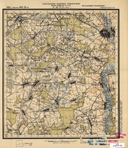
- Description:
- 1923
- Subject:
- Topical Subject: Maps, Geographic Subject: Chavusi, and Topical Subject: Soviet Union
- Publisher:
- Управление военных топографов
- Language:
- Russian
- Date Created:
- 1926
- Identifier:
- VAC9619-001402
- Genre:
- Topographic Maps and Military Maps
- Geographic Location:
- Coordinates: 53.667, 30.75, 53.833, 31
- Related URL:
- Catalog URL: http://iucat.iu.edu/catalog/5020131 and Download GeoTIFF: https://drive.google.com/open?id=19RCJP_F7aEs1hzwZ1krEnOEdA-MdnvHR
- Abstract:
- Modern area represented: Chavusi, Mogilev oblast, Belarus
- Call Number:
- GM G7000 S50 .S68 N-36-74-Г
- Caption:
- Не подлежит оглашению
- City:
- Чаусы (Chavusi)
- Copyright Holder:
- No Copyright - United States
- Country:
- СССР (USSR)
- State/Province:
- Белорусская ССР (Byelorussian Soviet Socialist Republic)
- Physical Description:
- Scale: 1:50,000
- Persistent URL:
- http://purl.dlib.indiana.edu/iudl/images/VAC9619/VAC9619-001402
- Provenance:
- M. I. Map Library
-
- Description:
- 1923
- Subject:
- Geographic Subject: Blagovichi, Topical Subject: Soviet Union, and Topical Subject: Maps
- Publisher:
- Управление военных топографов РККА
- Language:
- Russian
- Identifier:
- VAC9619-001400
- Genre:
- Military Maps and Topographic Maps
- Geographic Location:
- Coordinates: 53.883, 30.75, 54, 31
- Related URL:
- Catalog URL: http://iucat.iu.edu/catalog/5020131 and Download GeoTIFF: https://drive.google.com/open?id=1eiadXmLwaEhWybKU439VJC33Y76Dz8bl
- Abstract:
- Modern area represented: Blagovichi, Mogilev oblast, Belarus
- Call Number:
- GM G7000 S50 .S68 N-36-74-Б
- Caption:
- Не подлежит оглашению
- City:
- Благовичи (Blagovichi)
- Copyright Holder:
- No Copyright - United States
- Country:
- СССР (USSR)
- State/Province:
- Белорусская ССР (Byelorussian Soviet Socialist Republic)
- Physical Description:
- Scale: 1:50,000
- Persistent URL:
- http://purl.dlib.indiana.edu/iudl/images/VAC9619/VAC9619-001400
- Provenance:
- Library of Congress Geography & Map Division, Army Map Service Library, OMAHA
-
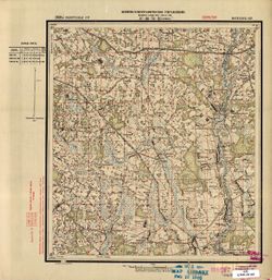
- Description:
- 1929
- Subject:
- Geographic Subject: Goleni, Topical Subject: Soviet Union, and Topical Subject: Maps
- Publisher:
- Военно-топографическое управление
- Language:
- Russian
- Identifier:
- VAC9619-001401
- Genre:
- Military Maps and Topographic Maps
- Geographic Location:
- Coordinates: 53.667, 30.5, 53.833, 30.75
- Related URL:
- Catalog URL: http://iucat.iu.edu/catalog/5020131 and Download GeoTIFF: https://drive.google.com/open?id=1BV4Dwp8i4A8x77fOV4CI3WD0Vl_svmlS
- Abstract:
- Modern area represented: Goleni, Mogilev oblast, Belarus
- Call Number:
- GM G7000 S50 .S68 N-36-74-B
- Caption:
- Секретно
- City:
- Голени (Goleni)
- Copyright Holder:
- No Copyright - United States
- Country:
- СССР (USSR)
- State/Province:
- Белорусская ССР (Byelorussian Soviet Socialist Republic) and Могилевский округ (Mogilev district)
- Physical Description:
- Scale: 1:50,000
- Persistent URL:
- http://purl.dlib.indiana.edu/iudl/images/VAC9619/VAC9619-001401
- Provenance:
- M. I. Map Library
-
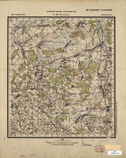
- Description:
- 1923
- Subject:
- Geographic Subject: Sukhary, Topical Subject: Maps, and Topical Subject: Soviet Union
- Publisher:
- Управление военных топографов РККА
- Language:
- Russian
- Date Created:
- 1924
- Identifier:
- VAC9619-001399
- Genre:
- Military Maps and Topographic Maps
- Geographic Location:
- Coordinates: 53.833, 30.5, 54, 30.75
- Related URL:
- Download GeoTIFF: https://drive.google.com/open?id=1dumq5lt2DDdAgLvoJZ0PcqZZMRlFZDzp and Catalog URL: http://iucat.iu.edu/catalog/5020131
- Abstract:
- Modern area represented: Sukhary, Mogilev oblast, Belarus
- Call Number:
- GM G7000 S50 .S68 N-36-74-A
- Caption:
- Не подлежит оглашению
- City:
- Сухари (Sukhary)
- Copyright Holder:
- No Copyright - United States
- Country:
- СССР (USSR)
- State/Province:
- Белорусская ССР (Byelorussian Soviet Socialist Republic)
- Physical Description:
- Scale: 1:50,000
- Persistent URL:
- http://purl.dlib.indiana.edu/iudl/images/VAC9619/VAC9619-001399
- Provenance:
- Library of Congress Geography & Map Division
-
- Subject:
- Geographic Subject: Chavusy, Topical Subject: Soviet Union, and Topical Subject: Maps
- Publisher:
- Генеральный штаб Красной Армии
- Language:
- Russian
- Identifier:
- VAC9619-001902
- Genre:
- Topographic Maps and Military Maps
- Geographic Location:
- Coordinates: 53.6667, 30.5, 54, 31
- Related URL:
- Catalog URL: https://iucat.iu.edu/catalog/5020129 and Download GeoTIFF: https://drive.google.com/open?id=16yCs0Sf1eID6TNF6PVS2nUIZ-5w8DJUu
- Abstract:
- Modern area represented: Чавусы (Chavusy), Mogilev district, Belarus
- Call Number:
- G7000 s100 .S7 sheet N-36-74
- Caption:
- Для служебного пользования
- City:
- Чаусы (Chavusy)
- Copyright Holder:
- No Copyright - United States
- Country:
- СССР (USSR)
- State/Province:
- Белорусская ССР (Byelorussian Soviet Socialist Republic)
- Physical Description:
- Scale: 1:100,000
- Persistent URL:
- http://purl.dlib.indiana.edu/iudl/images/VAC9619/VAC9619-001902
- Provenance:
- DMA Topographic Center, Army Map Service Library, OMAHA, Library of Congress Geography & Map Division
-
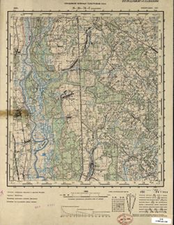
- Description:
- 1936
- Subject:
- Geographic Subject: Dashkovka, Topical Subject: Soviet Union, and Topical Subject: Maps
- Publisher:
- Управление военных топографов РККА
- Language:
- Russian
- Identifier:
- VAC9619-001398
- Genre:
- Military Maps and Topographic Maps
- Geographic Location:
- Coordinates: 53.667, 30.25, 53.833, 30.5
- Related URL:
- Catalog URL: http://iucat.iu.edu/catalog/5020131 and Download GeoTIFF: https://drive.google.com/open?id=1QaWQy23l6FtxRyK2BJ9gQoxvKzTP6cMf
- Abstract:
- Modern area represented: Dashkovka, Mogilev oblast, Belarus
- Call Number:
- GM G7000 S50 .S68 N-36-73-Г
- Caption:
- Не подлежит оглашению
- City:
- Дашковка (Dashkovka)
- Copyright Holder:
- No Copyright - United States
- Country:
- СССР (USSR)
- State/Province:
- Белорусская ССР (Byelorussian Soviet Socialist Republic)
- Physical Description:
- Scale: 1:50,000
- Persistent URL:
- http://purl.dlib.indiana.edu/iudl/images/VAC9619/VAC9619-001398
- Provenance:
- Library of Congress Geography & Map Division
-
- Description:
- 1936
- Subject:
- Topical Subject: Soviet Union, Geographic Subject: Mogilev, and Topical Subject: Maps
- Publisher:
- Генеральный штаб РККА
- Language:
- Russian
- Identifier:
- VAC9619-001396
- Genre:
- Topographic Maps and Military Maps
- Geographic Location:
- Coordinates: 53.833, 30.25, 54, 30.5
- Related URL:
- Catalog URL: http://iucat.iu.edu/catalog/5020131 and Download GeoTIFF: https://drive.google.com/open?id=1naOUm_VpQfvEOrgageH9eub5S5K-TbtU
- Abstract:
- Modern area represented: Mogilev, Mogilev oblast, Belarus
- Call Number:
- GM G7000 S50 .S68 N-36-73-Б
- Caption:
- Не подлежит оглашению
- City:
- Могилев (Mogilev)
- Copyright Holder:
- No Copyright - United States
- Country:
- СССР (USSR)
- State/Province:
- Белорусская ССР (Byelorussian Soviet Socialist Republic)
- Physical Description:
- Scale: 1:50,000
- Persistent URL:
- http://purl.dlib.indiana.edu/iudl/images/VAC9619/VAC9619-001396
- Provenance:
- Library of Congress Geography & Map Division, Army Map Service Library, OMAHA
-
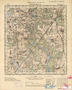
- Description:
- 1936
- Subject:
- Topical Subject: Maps, Topical Subject: Soviet Union, and Geographic Subject: Mezhisyatki
- Publisher:
- Управление военных топографов РККА
- Language:
- Russian
- Identifier:
- VAC9619-001397
- Genre:
- Military Maps and Topographic Maps
- Geographic Location:
- Coordinates: 53.667, 30, 53.833, 30.25
- Related URL:
- Download GeoTIFF: https://drive.google.com/open?id=1bYNukxBy97BrCwOss3GOlRRA984CXkOZ and Catalog URL: http://iucat.iu.edu/catalog/5020131
- Abstract:
- Modern area represented: Mezhisyatki, Mogilev oblast, Belarus
- Call Number:
- GM G7000 S50 .S68 N-36-73-B
- Caption:
- Не подлежит оглашению
- City:
- Межисятки (Mezhisyatki)
- Copyright Holder:
- No Copyright - United States
- Country:
- СССР (USSR)
- State/Province:
- Белорусская ССР (Byelorussian Soviet Socialist Republic)
- Physical Description:
- Scale: 1:50,000
- Persistent URL:
- http://purl.dlib.indiana.edu/iudl/images/VAC9619/VAC9619-001397
- Provenance:
- M. I. Map Library, GS, RA
-
- Description:
- 1936
- Subject:
- Topical Subject: Soviet Union, Geographic Subject: Knyazhitsy, and Topical Subject: Maps
- Publisher:
- Управление военных топографов РККА
- Language:
- Russian
- Identifier:
- VAC9619-001395
- Genre:
- Military Maps and Topographic Maps
- Geographic Location:
- Coordinates: 53.833, 30, 54, 30.25
- Related URL:
- Catalog URL: http://iucat.iu.edu/catalog/5020131 and Download GeoTIFF: https://drive.google.com/open?id=1Xy_l5e1nJrocil-Mj55vvGuSXu6ykorV
- Abstract:
- Modern area represented: Knyazhitsy, Mogilev oblast, Belarus
- Call Number:
- GM G7000 S50 .S68 N-36-73-A
- Caption:
- Не подлежит оглашению
- City:
- Княжицы (Knyazhitsy)
- Copyright Holder:
- No Copyright - United States
- Country:
- СССР (USSR)
- State/Province:
- Белорусская ССР (Byelorussian Soviet Socialist Republic)
- Physical Description:
- Scale: 1:50,000
- Persistent URL:
- http://purl.dlib.indiana.edu/iudl/images/VAC9619/VAC9619-001395
- Provenance:
- DMA Topographic Center, Army Map Service Library, OMAHA, M. I. Map Library
-
- Description:
- 1936
- Subject:
- Geographic Subject: Mogilev, Topical Subject: Maps, and Topical Subject: Soviet Union
- Publisher:
- Генеральный штаб РККА
- Language:
- Russian
- Identifier:
- VAC9619-001901
- Genre:
- Military Maps and Topographic Maps
- Geographic Location:
- Coordinates: 53.6667, 30, 54, 30.5
- Related URL:
- Catalog URL: https://iucat.iu.edu/catalog/5020129 and Download GeoTIFF: https://drive.google.com/open?id=1B5C8qUK3OYLwhVFNQv36U_aJV289Zg9E
- Abstract:
- Modern area represented: Магілёў (Mogilev), Belarus
- Call Number:
- G7000 s100 .S7 sheet N-36-73
- Caption:
- Не подлежит оглашению
- City:
- Могилев (Mogilev)
- Copyright Holder:
- No Copyright - United States
- Country:
- СССР (USSR)
- State/Province:
- Белорусская ССР (Byelorussian Soviet Socialist Republic) and Могилевская область (Mogilev oblast)
- Physical Description:
- Scale: 1:100,000
- Persistent URL:
- http://purl.dlib.indiana.edu/iudl/images/VAC9619/VAC9619-001901
- Provenance:
- DMA Topographic Center, Army Map Service Library, OMAHA, Library of Congress Geography & Map Division
-
- Description:
- 1924
- Subject:
- Topical Subject: Maps, Geographic Subject: Gryaz, and Topical Subject: Soviet Union
- Publisher:
- Военно-топографическое управление
- Language:
- Russian
- Identifier:
- VAC9619-001377
- Genre:
- Military Maps and Topographic Maps
- Geographic Location:
- Coordinates: 54, 31.75, 54.1667, 32
- Related URL:
- Download GeoTIFF: https://drive.google.com/open?id=1zQCWa7tYT5eM3rPqtisCNifaQRC3RW72 and Catalog URL: http://iucat.iu.edu/catalog/5020131
- Abstract:
- Modern area represented: Gryaz, Smolensk oblast, Russia
- Call Number:
- GM G7000 S50 .S68 N-36-64-Г
- Caption:
- Секретно
- City:
- Грязь (Gryaz)
- Copyright Holder:
- No Copyright - United States
- Country:
- СССР (USSR)
- State/Province:
- Белорусская ССР (Byelorussian Soviet Socialist Republic), РСФСР (RSFSR), and Западная область (Western oblast)
- Physical Description:
- Scale: 1:50,000
- Persistent URL:
- http://purl.dlib.indiana.edu/iudl/images/VAC9619/VAC9619-001377
- Provenance:
- M. I. Map Library, GS, RA, OMAHA, Atlasblatt, Library of Congress Geography & Map Division
-
- Description:
- 1924
- Subject:
- Topical Subject: Maps, Geographic Subject: Mstsislaw, and Topical Subject: Soviet Union
- Publisher:
- Военно-топографическое управление
- Language:
- Russian
- Identifier:
- VAC9619-001376
- Genre:
- Military Maps and Topographic Maps
- Geographic Location:
- Coordinates: 54, 31.5, 54.1667, 31.75
- Related URL:
- Catalog URL: http://iucat.iu.edu/catalog/5020131 and Download GeoTIFF: https://drive.google.com/file/d/1YNNrtmv7rSKmpUF9glMZZITRcHm2LvKk/view?usp=sharing
- Abstract:
- Modern area represented: Mstsislaw, Mogilev oblast, Belarus
- Call Number:
- GM G7000 S50 .S68 N-36-64-B2
- Caption:
- Секретно
- City:
- Мстиславль (Mstsislaw)
- Copyright Holder:
- No Copyright - United States
- Country:
- СССР (USSR)
- State/Province:
- Белорусская ССР (Byelorussian Soviet Socialist Republic), Смоленская область (Smolensk oblast), and РСФСР (RSFSR)
- Physical Description:
- Scale: 1:50,000
- Persistent URL:
- http://purl.dlib.indiana.edu/iudl/images/VAC9619/VAC9619-001376
- Provenance:
- M. I. Map Library, Atlasblatt, Library of Congress Geography & Map Division
-
- Description:
- 1924
- Subject:
- Geographic Subject: Mstsislaw, Topical Subject: Soviet Union, and Topical Subject: Maps
- Publisher:
- Управление военных топографов
- Language:
- Russian
- Identifier:
- VAC9619-001375
- Genre:
- Military Maps and Topographic Maps
- Geographic Location:
- Coordinates: 54, 31.5, 54.1667, 31.75
- Related URL:
- Download GeoTIFF: https://drive.google.com/file/d/1L1ah-Q0gps1bW43RnmJmxuVOEQY7S9NL/view?usp=sharing and Catalog URL: http://iucat.iu.edu/catalog/5020131
- Abstract:
- Modern area represented: Mstsislaw, Mogilev oblast, Belarus
- Call Number:
- GM G7000 S50 .S68 N-36-64-B
- Caption:
- Не подлежит оглашению
- City:
- Мстиславль (Mstsislaw)
- Copyright Holder:
- No Copyright - United States
- Country:
- СССР (USSR)
- State/Province:
- РСФСР (RSFSR), Белорусская ССР (Byelorussian Soviet Socialist Republic), and Западная область (Western oblast)
- Physical Description:
- Scale: 1:50,000
- Persistent URL:
- http://purl.dlib.indiana.edu/iudl/images/VAC9619/VAC9619-001375
- Provenance:
- M. I. Map Library
-

- Description:
- 1924
- Subject:
- Geographic Subject: Tatarsk, Topical Subject: Maps, and Topical Subject: Soviet Union
- Publisher:
- Управление военных топографов
- Language:
- Russian
- Identifier:
- VAC9619-001373
- Genre:
- Topographic Maps and Military Maps
- Geographic Location:
- Coordinates: 54.167, 31.5, 54.333, 31.75
- Related URL:
- Catalog URL: http://iucat.iu.edu/catalog/5020131 and Download GeoTIFF: https://drive.google.com/open?id=1i1g0zyiz8i8nDK20MIZq8VFAYlEXqWpb
- Abstract:
- Modern area represented: Tatarsk, Smolensk oblast, Russia
- Call Number:
- GM G7000 S50 .S68 N-36-64-A
- Caption:
- Не подлежит оглашению
- City:
- Татарск (Tatarsk)
- Copyright Holder:
- No Copyright - United States
- Country:
- СССР (USSR)
- State/Province:
- Западная область (Western oblast), РСФСР (RSFSR), and Белорусская ССР (Byelorussian Soviet Socialist Republic)
- Physical Description:
- Scale: 1:50,000
- Persistent URL:
- http://purl.dlib.indiana.edu/iudl/images/VAC9619/VAC9619-001373
- Provenance:
- M. I. Map Library
-

- Description:
- 1924
- Subject:
- Geographic Subject: Mstsislaw, Topical Subject: Maps, and Topical Subject: Soviet Union
- Publisher:
- Генеральный штаб Красной Армии
- Language:
- Russian
- Date Created:
- 1941
- Identifier:
- VAC9619-001897
- Genre:
- Topographic Maps and Military Maps
- Geographic Location:
- Coordinates: 54, 31.5, 54.3333, 32
- Related URL:
- Download GeoTIFF: https://drive.google.com/open?id=1cQOJFMLkO5dpaGIkGEO-kIOTaYAKr-az and Catalog URL: https://iucat.iu.edu/catalog/5020129
- Abstract:
- Modern are represented: Мсціслаў (Mstsislaw), Mogilev Region, Belarus
- Call Number:
- G7000 s100 .S7 sheet N-36-64
- Caption:
- Для служебного пользования
- City:
- Мстиславль (Mstsislaw)
- Copyright Holder:
- No Copyright - United States
- Country:
- СССР (USSR)
- State/Province:
- Белорусская ССР (Byelorussian Soviet Socialist Republic), Могилевская область (Mogilev oblast), РСФСР (RSFSR), and Смоленская область (Smolensk oblast)
- Physical Description:
- Scale: 1:100,000
- Persistent URL:
- http://purl.dlib.indiana.edu/iudl/images/VAC9619/VAC9619-001897
- Provenance:
- DMA Topographic Center, Army Map Service Library, Library of Congress Geography & Map Division
-
- Description:
- 1924
- Subject:
- Topical Subject: Soviet Union, Geographic Subject: Asmolovichi, and Topical Subject: Maps
- Publisher:
- Управление военных топографов
- Language:
- Russian
- Identifier:
- VAC9619-001372
- Genre:
- Topographic Maps and Military Maps
- Geographic Location:
- Coordinates: 54, 31.25, 54.167, 31.5
- Related URL:
- Catalog URL: http://iucat.iu.edu/catalog/5020131 and Download GeoTIFF: https://drive.google.com/open?id=1VM4K69J5SlQuZvKlik8eslaZ7oxNbM0O
- Abstract:
- Modern area represented: Asmolovichi, Mogilev oblast, Belarus
- Call Number:
- GM G7000 S50 .S68 N-36-63-Г
- Caption:
- Не подлежит оглашению
- City:
- Асмоловичи (Asmolovichi)
- Copyright Holder:
- No Copyright - United States
- Country:
- СССР (USSR)
- State/Province:
- Белорусская ССР (Byelorussian Soviet Socialist Republic)
- Physical Description:
- Scale: 1:50,000
- Persistent URL:
- http://purl.dlib.indiana.edu/iudl/images/VAC9619/VAC9619-001372
- Provenance:
- M. I. Map Library, Reichsamt für Landesaufnahme, Kartensammlung
-
- Description:
- 1924
- Subject:
- Topical Subject: Soviet Union, Geographic Subject: Shamovo, and Topical Subject: Maps
- Publisher:
- Военно-топографическое управление
- Language:
- Russian
- Identifier:
- VAC9619-001370
- Genre:
- Topographic Maps and Military Maps
- Geographic Location:
- Coordinates: 54.167, 31.25, 54.333, 31.5
- Related URL:
- Download GeoTIFF: https://drive.google.com/open?id=115C2WorHArrVdBWJ3bF4PEhN48TSRXE9 and Catalog URL: http://iucat.iu.edu/catalog/5020131
- Abstract:
- Modern area represented: Shamovo, Mogilev oblast, Belarus
- Call Number:
- GM G7000 S50 .S68 N-36-63-Б
- Caption:
- Секретно
- City:
- Шамово (Shamovo)
- Copyright Holder:
- No Copyright - United States
- Country:
- СССР (USSR)
- State/Province:
- Белорусская ССР (Byelorussian Soviet Socialist Republic), РСФСР (RSFSR), and Смоленская область (Smolensk oblast)
- Physical Description:
- Scale: 1:50,000
- Persistent URL:
- http://purl.dlib.indiana.edu/iudl/images/VAC9619/VAC9619-001370
- Provenance:
- CIA Map Branch -- Received, M. I. Map Library
-
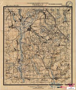
- Description:
- 1923
- Subject:
- Geographic Subject: Drybin, Topical Subject: Maps, and Topical Subject: Soviet Union
- Publisher:
- Управление военных топографов
- Language:
- Russian
- Date Created:
- 1925
- Identifier:
- VAC9619-001371
- Genre:
- Military Maps and Topographic Maps
- Geographic Location:
- Coordinates: 54, 31, 54.167, 31.25
- Related URL:
- Catalog URL: http://iucat.iu.edu/catalog/5020131 and Download GeoTIFF: https://drive.google.com/open?id=1-mVksZJMmIbSI3ShOxffoWgeB6Bl-fhf
- Abstract:
- Modern area represented: Drybin, Mogilev oblast, Belarus
- Call Number:
- GM G7000 S50 .S68 N-36-63-B
- Caption:
- Не подлежит оглашению
- City:
- Дрибин (Drybin)
- Copyright Holder:
- No Copyright - United States
- Country:
- СССР (USSR)
- State/Province:
- Белорусская ССР (Byelorussian Soviet Socialist Republic)
- Physical Description:
- Scale: 1:50,000
- Persistent URL:
- http://purl.dlib.indiana.edu/iudl/images/VAC9619/VAC9619-001371
- Provenance:
- M. I. Map Library, Atlasblatt
-
- Description:
- 1923
- Subject:
- Topical Subject: Soviet Union, Geographic Subject: Hory, and Topical Subject: Maps
- Publisher:
- Военно-топографическое управление
- Language:
- Russian
- Date Created:
- 1924
- Identifier:
- VAC9619-001369
- Genre:
- Topographic Maps and Military Maps
- Geographic Location:
- Coordinates: 54.167, 31, 54.333, 31.25
- Related URL:
- Download GeoTIFF: https://drive.google.com/file/d/18og9QwbnqFJtcBz8ao60V6dUPGuGHrDo/view?usp=sharing and Catalog URL: http://iucat.iu.edu/catalog/5020131
- Abstract:
- Modern area represented: Hory, Mogilev oblast, Belarus
- Call Number:
- GM G7000 S50 .S68 N-36-63-A
- City:
- Горы (Hory)
- Copyright Holder:
- No Copyright - United States
- Country:
- СССР (USSR)
- State/Province:
- Западная область (Western oblast), Белорусская ССР (Byelorussian Soviet Socialist Republic), and РСФСР (RSFSR)
- Physical Description:
- Scale: 1:50,000
- Persistent URL:
- http://purl.dlib.indiana.edu/iudl/images/VAC9619/VAC9619-001369
- Provenance:
- Army Map Service Library, OMAHA, Library of Congress Geography & Map Division
-
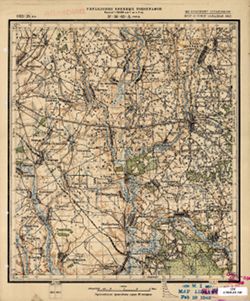
- Description:
- 1923
- Subject:
- Geographic Subject: Hory, Topical Subject: Soviet Union, and Topical Subject: Maps
- Publisher:
- Управление военных топографов
- Language:
- Russian
- Date Created:
- 1924
- Identifier:
- VAC9619-001368
- Genre:
- Topographic Maps and Military Maps
- Geographic Location:
- Coordinates: 54.167, 31, 54.333, 31.25
- Related URL:
- Download GeoTIFF: https://drive.google.com/open?id=1PGtQApcjuRTM8uCgJZ8C7o09n4D75-Qa and Catalog URL: http://iucat.iu.edu/catalog/5020131
- Abstract:
- Modern area represented: Hory, Mogilev oblast, Belarus
- Call Number:
- GM G7000 S50 .S68 N-36-63-A
- Caption:
- Не подлежит оглашению
- City:
- Горы (Hory)
- Copyright Holder:
- No Copyright - United States
- Country:
- СССР (USSR)
- State/Province:
- Белорусская ССР (Byelorussian Soviet Socialist Republic), Западная область (Western oblast), and РСФСР (RSFSR)
- Physical Description:
- Scale: 1:50,000
- Persistent URL:
- http://purl.dlib.indiana.edu/iudl/images/VAC9619/VAC9619-001368
- Provenance:
- M. I. Map Library, Atlasblatt
-
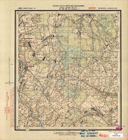
- Description:
- 1929
- Subject:
- Topical Subject: Maps, Geographic Subject: Chernyewka, and Topical Subject: Soviet Union
- Publisher:
- Военно-топографическое управление
- Language:
- Russian
- Identifier:
- VAC9619-001367
- Genre:
- Military Maps and Topographic Maps
- Geographic Location:
- Coordinates: 54, 30.75, 54.167, 31
- Related URL:
- Download GeoTIFF: https://drive.google.com/open?id=1ks1AbVqIAR5BcadeBjkMuTy0LpsWS-jY and Catalog URL: http://iucat.iu.edu/catalog/5020131
- Abstract:
- Modern area represented: Chernyewka, Mogilev oblast, Belarus
- Call Number:
- GM G7000 S50 .S68 N-36-62-Г
- Caption:
- Секретно
- City:
- Черневка (Chernyewka)
- Copyright Holder:
- No Copyright - United States
- Country:
- СССР (USSR)
- State/Province:
- Белорусская ССР (Byelorussian Soviet Socialist Republic) and Могилевский округ (Mogilev district)
- Physical Description:
- Scale: 1:50,000
- Persistent URL:
- http://purl.dlib.indiana.edu/iudl/images/VAC9619/VAC9619-001367
- Provenance:
- M. I. Map Library
-
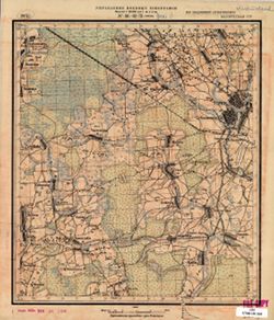
- Description:
- 1923
- Subject:
- Topical Subject: Soviet Union, Topical Subject: Maps, and Geographic Subject: Horki
- Publisher:
- Управление военных топографов
- Language:
- Russian
- Identifier:
- VAC9619-001363
- Genre:
- Topographic Maps and Military Maps
- Geographic Location:
- Coordinates: 54.167, 30.75, 54.333, 31
- Related URL:
- Catalog URL: http://iucat.iu.edu/catalog/5020131 and Download GeoTIFF: https://drive.google.com/open?id=1d4DJX78EQahinfoNzjQvHFwgz-zWGhV2
- Abstract:
- Modern area represented: Horki, Mogilev oblast, Belarus
- Call Number:
- GM G7000 S50 .S68 N-36-62-Б
- Caption:
- Не подлежит оглашению
- City:
- Горки (Horki)
- Copyright Holder:
- No Copyright - United States
- Country:
- СССР (USSR)
- State/Province:
- Белорусская ССР (Byelorussian Soviet Socialist Republic)
- Physical Description:
- Scale: 1:50,000
- Persistent URL:
- http://purl.dlib.indiana.edu/iudl/images/VAC9619/VAC9619-001363
- Provenance:
- FEM Austria
-
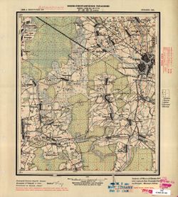
- Description:
- 1923
- Subject:
- Topical Subject: Maps, Geographic Subject: Horki, and Topical Subject: Soviet Union
- Publisher:
- Военно-топографическое управление
- Language:
- Russian
- Identifier:
- VAC9619-001364
- Genre:
- Topographic Maps and Military Maps
- Geographic Location:
- Coordinates: 54.137, 30.75, 54.333, 31
- Related URL:
- Catalog URL: http://iucat.iu.edu/catalog/5020131 and Download GeoTIFF: https://drive.google.com/file/d/1Hwx_hexlWxLsmP-QmjM5BVK_GFpTdPW8/view?usp=sharing
- Abstract:
- Modern area represented: Horki, Mogilev oblast, Belarus
- Call Number:
- GM G7000 S50 .S68 N-36-62-Б
- City:
- Горки (Horki)
- Copyright Holder:
- No Copyright - United States
- Country:
- СССР (USSR)
- State/Province:
- Белорусская ССР (Byelorussian Soviet Socialist Republic)
- Physical Description:
- Scale: 1:50,000
- Persistent URL:
- http://purl.dlib.indiana.edu/iudl/images/VAC9619/VAC9619-001364
- Provenance:
- M. I. Map Library, Atlasblatt
-
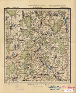
- Description:
- 1923
- Subject:
- Geographic Subject: Ordat, Topical Subject: Maps, and Topical Subject: Soviet Union
- Publisher:
- Управление военных топографов РККА
- Language:
- Russian
- Date Created:
- 1924
- Identifier:
- VAC9619-001365
- Genre:
- Military Maps and Topographic Maps
- Geographic Location:
- Coordinates: 54, 30.5, 54.167, 30.75
- Related URL:
- Catalog URL: http://iucat.iu.edu/catalog/5020131 and Download GeoTIFF: https://drive.google.com/open?id=1jxqpK4WxNHZB4VFSzNUlIzIBL707SBkY
- Abstract:
- Modern area represented: Ordat, Mogilev oblast, Belarus
- Call Number:
- GM G7000 S50 .S68 N-36-62-B
- Caption:
- Не подлежит оглашению
- City:
- Ордат (Ordat)
- Copyright Holder:
- No Copyright - United States
- Country:
- СССР (USSR)
- State/Province:
- Белорусская ССР (Byelorussian Soviet Socialist Republic)
- Physical Description:
- Scale: 1:50,000
- Persistent URL:
- http://purl.dlib.indiana.edu/iudl/images/VAC9619/VAC9619-001365
- Provenance:
- M. I. Map Library, Reichsamt für Landesaufnahme, Kartensammlung
-
- Description:
- 1923
- Subject:
- Geographic Subject: Vasilevichi, Topical Subject: Soviet Union, and Topical Subject: Maps
- Publisher:
- Военно-топографическое управление
- Language:
- Russian
- Identifier:
- VAC9619-001366
- Genre:
- Topographic Maps and Military Maps
- Geographic Location:
- Coordinates: 54, 30.5, 54.167, 30.75
- Related URL:
- Catalog URL: http://iucat.iu.edu/catalog/5020131 and Download GeoTIFF: https://drive.google.com/file/d/1vxaFjTiQqLS6qSVslhiFG4VlEHTBiFVo/view?usp=sharing
- Abstract:
- Modern area represented: Vasilevichi, Mogilev oblast, Belarus
- Call Number:
- GM G7000 S50 .S68 N-36-62-B
- City:
- Василевичи (Vasilevichi)
- Copyright Holder:
- No Copyright - United States
- Country:
- СССР (USSR)
- State/Province:
- Белорусская ССР (Byelorussian Soviet Socialist Republic) and Могилевский округ (Mogilev district)
- Physical Description:
- Scale: 1:50,000
- Persistent URL:
- http://purl.dlib.indiana.edu/iudl/images/VAC9619/VAC9619-001366
- Provenance:
- Library of Congress Geography & Map Division, Army Map Service Library
-
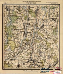
- Description:
- 1923
- Subject:
- Geographic Subject: Maslaki, Topical Subject: Maps, and Topical Subject: Soviet Union
- Publisher:
- Управление военных топографов
- Language:
- Russian
- Identifier:
- VAC9619-001362
- Genre:
- Topographic Maps and Military Maps
- Geographic Location:
- Coordinates: 54.167, 30.5, 54.333, 30.75
- Related URL:
- Catalog URL: http://iucat.iu.edu/catalog/5020131 and Download GeoTIFF: https://drive.google.com/open?id=1fqFsha9G8yIJ3gmmQAYUZM4Fx4GpYV6Y
- Abstract:
- Modern area represented: Maslaki, Mogilev oblast, Belarus
- Call Number:
- GM G7000 S50 .S68 N-36-62-A
- Caption:
- Не подлежит оглашению
- City:
- Маслаки (Maslaki)
- Copyright Holder:
- No Copyright - United States
- Country:
- СССР (USSR)
- State/Province:
- Белорусская ССР (Byelorussian Soviet Socialist Republic)
- Physical Description:
- Scale: 1:50,000
- Persistent URL:
- http://purl.dlib.indiana.edu/iudl/images/VAC9619/VAC9619-001362
- Provenance:
- M. I. Map Library, GS, RA
-
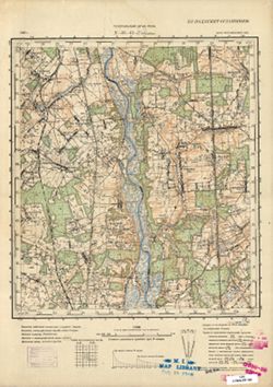
- Description:
- 1937
- Subject:
- Geographic Subject: Pleshchitsy, Topical Subject: Maps, and Topical Subject: Soviet Union
- Publisher:
- Генеральный штаб РККА
- Language:
- Russian
- Identifier:
- VAC9619-001361
- Genre:
- Topographic Maps and Military Maps
- Geographic Location:
- Coordinates: 54, 30.25, 54.167, 30.5
- Related URL:
- Download GeoTIFF: https://drive.google.com/open?id=1bpLHzfwj5Sl_n7I-H7w2b8YqDAKoe9S_ and Catalog URL: http://iucat.iu.edu/catalog/5020131
- Abstract:
- Modern area represented: Pleshchitsy, Mogilev oblast, Belarus
- Call Number:
- GM G7000 S50 .S68 N-36-61-Г
- Caption:
- Не подлежит оглашению
- City:
- Плещицы (Pleshchitsy)
- Copyright Holder:
- No Copyright - United States
- Country:
- СССР (USSR)
- State/Province:
- Могилевская область (Mogilev oblast) and Белорусская ССР (Byelorussian Soviet Socialist Republic)
- Physical Description:
- Scale: 1:50,000
- Persistent URL:
- http://purl.dlib.indiana.edu/iudl/images/VAC9619/VAC9619-001361
- Provenance:
- M. I. Map Library, Reichsamt für Landesaufnahme, Kartensammlung, GS, RA
-
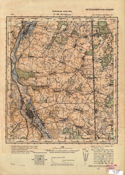
- Description:
- 1937
- Subject:
- Topical Subject: Maps, Topical Subject: Soviet Union, and Geographic Subject: Shklow
- Publisher:
- Генеральный штаб РККА
- Language:
- Russian
- Identifier:
- VAC9619-001359
- Genre:
- Topographic Maps and Military Maps
- Geographic Location:
- Coordinates: 54.167, 30.25, 54.333, 30.5
- Related URL:
- Download GeoTIFF: https://drive.google.com/open?id=15_vWo6_GXlJ6d3nBoj9TcyMcr36TWfpA and Catalog URL: http://iucat.iu.edu/catalog/5020131
- Abstract:
- Modern area represented: Shklow, Mogilev oblast, Belarus
- Call Number:
- GM G7000 S50 .S68 N-36-61-Б
- Caption:
- Не подлежит оглашению
- City:
- Шклов (Shklow)
- Copyright Holder:
- No Copyright - United States
- Country:
- СССР (USSR)
- State/Province:
- Белорусская ССР (Byelorussian Soviet Socialist Republic), Витебская область (Vitebsk oblast), and Могилевская область (Mogilev oblast)
- Physical Description:
- Scale: 1:50,000
- Persistent URL:
- http://purl.dlib.indiana.edu/iudl/images/VAC9619/VAC9619-001359
- Provenance:
- CIA Map Branch -- Received
-
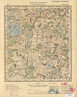
- Description:
- 1936
- Subject:
- Geographic Subject: Staraya Vodva, Topical Subject: Soviet Union, and Topical Subject: Maps
- Publisher:
- Управление военных топографов РККА
- Language:
- Russian
- Identifier:
- VAC9619-001360
- Genre:
- Military Maps and Topographic Maps
- Geographic Location:
- Coordinates: 54, 30, 54.1667, 30.25
- Related URL:
- Catalog URL: http://iucat.iu.edu/catalog/5020131 and Download GeoTIFF: https://drive.google.com/open?id=1UJgOmQFinMKTGb94FAm3yjvFTA510yVz
- Abstract:
- Modern area represented: Staraya Vodva, Mogilev oblast, Belarus
- Call Number:
- GM G7000 S50 .S68 N-36-61-B
- Caption:
- Не подлежит оглашению
- City:
- Старая Водва (Staraya Vodva)
- Copyright Holder:
- No Copyright - United States
- Country:
- СССР (USSR)
- State/Province:
- Белорусская ССР (Byelorussian Soviet Socialist Republic)
- Physical Description:
- Scale: 1:50,000
- Persistent URL:
- http://purl.dlib.indiana.edu/iudl/images/VAC9619/VAC9619-001360
- Provenance:
- M. I. Map Library, Reichsamt für Landesaufnahme, Kartensammlung, GS, RA
-
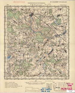
- Description:
- 1936
- Subject:
- Topical Subject: Soviet Union, Geographic Subject: Staroselje, and Topical Subject: Maps
- Publisher:
- Управление военных топографов РККА
- Language:
- Russian
- Identifier:
- VAC9619-001358
- Genre:
- Topographic Maps and Military Maps
- Geographic Location:
- Coordinates: 54.167, 30, 54.333, 30.25
- Related URL:
- Download GeoTIFF: https://drive.google.com/open?id=1mJQEPtRDCi4mtsWY57pbOdHfup0Eoz4T and Catalog URL: http://iucat.iu.edu/catalog/5020131
- Abstract:
- Modern area represented: Staroselje, Mogilev oblast, Belarus
- Call Number:
- GM G7000 S50 .S68 N-36-61-A
- Caption:
- Не подлежит оглашению
- City:
- Староселье (Staroselje)
- Copyright Holder:
- No Copyright - United States
- Country:
- СССР (USSR)
- State/Province:
- Белорусская ССР (Byelorussian Soviet Socialist Republic)
- Physical Description:
- Scale: 1:50,000
- Persistent URL:
- http://purl.dlib.indiana.edu/iudl/images/VAC9619/VAC9619-001358
- Provenance:
- M. I. Map Library, Atlasblatt, GS, RA
-
- Subject:
- Geographic Subject: Shklow, Topical Subject: Soviet Union, and Topical Subject: Maps
- Publisher:
- Генеральный штаб РККА
- Language:
- Russian
- Identifier:
- VAC9619-001896
- Genre:
- Military Maps and Topographic Maps
- Geographic Location:
- Coordinates: 54, 30, 54.3333, 30.5
- Related URL:
- Download GeoTIFF: https://drive.google.com/open?id=1ppQZx0t-P5jAP3doeU83SKBc3RKDsNo8 and Catalog URL: https://iucat.iu.edu/catalog/5020129
- Abstract:
- Modern area represented: Шклоў (Shklow), Mogilev region, Belarus
- Call Number:
- G7000 s100 .S7 sheet N-36-61
- Caption:
- Не подлежит оглашению
- City:
- Шклов (Shklow)
- Copyright Holder:
- No Copyright - United States
- Country:
- СССР (USSR)
- State/Province:
- Витебская область (Vitebsk oblast), Белорусская ССР (Byelorussian Soviet Socialist Republic), and Могилевская область (Mogilev oblast)
- Physical Description:
- Scale: 1:100,000
- Persistent URL:
- http://purl.dlib.indiana.edu/iudl/images/VAC9619/VAC9619-001896
- Provenance:
- DMA Topographic Center, Army Map Service Library, OMAHA
-
- Description:
- 1924
- Subject:
- Topical Subject: Maps, Geographic Subject: Gorodets, and Topical Subject: Soviet Union
- Publisher:
- Управление военных топографов
- Language:
- Russian
- Identifier:
- VAC9619-001332
- Genre:
- Topographic Maps and Military Maps
- Geographic Location:
- Coordinates: 54.3333, 31.25, 54.5, 31.5
- Related URL:
- Catalog URL: http://iucat.iu.edu/catalog/5020131 and Download GeoTIFF: https://drive.google.com/file/d/1Vkoo6gEhtlplQPLMCqy5w6_s0syy8isC/view?usp=sharing
- Abstract:
- Modern area represented: Gorodets, Mogilev oblast, Belarus
- Call Number:
- GM G7000 S50 .S68 N-36-51-Г
- Caption:
- Не подлежит оглашению
- City:
- Городец (Gorodets)
- Copyright Holder:
- No Copyright - United States
- Country:
- СССР (USSR)
- State/Province:
- Белорусская ССР (Byelorussian Soviet Socialist Republic), Западная область (Western oblast), and РСФСР (RSFSR)
- Physical Description:
- Scale: 1:50,000
- Persistent URL:
- http://purl.dlib.indiana.edu/iudl/images/VAC9619/VAC9619-001332
- Provenance:
- DMA Topographic Center, Army Map Service Library, OMAHA, Library of Congress Geography & Map Division
-
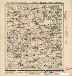
- Description:
- 1924
- Subject:
- Geographic Subject: Gorodets, Topical Subject: Maps, and Topical Subject: Soviet Union
- Language:
- Russian
- Identifier:
- VAC9619-001331
- Genre:
- Military Maps and Topographic Maps
- Geographic Location:
- Coordinates: 54.3333, 31.25, 54.5, 31.5
- Related URL:
- Download GeoTIFF: https://drive.google.com/open?id=1sGMe0GRXj9YUoPN47VUeWTw7pJmd7Uwz and Catalog URL: http://iucat.iu.edu/catalog/5020131
- Abstract:
- Modern area represented: Gorodets, Mogilev oblast, Belarus
- Call Number:
- GM G7000 S50 .S68 N-36-51-Г
- Copyright Holder:
- No Copyright - United States
- Country:
- СССР (USSR)
- State/Province:
- Белорусская ССР (Byelorussian Soviet Socialist Republic)
- Physical Description:
- Scale: 1:50,000
- Persistent URL:
- http://purl.dlib.indiana.edu/iudl/images/VAC9619/VAC9619-001331
- Provenance:
- M. I. Map Library, G000-30
-
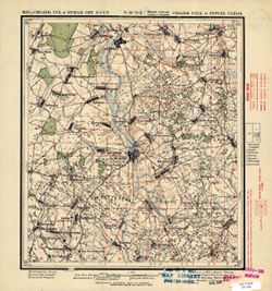
- Description:
- 1923
- Subject:
- Topical Subject: Soviet Union, Geographic Subject: Lyenina, and Topical Subject: Maps
- Language:
- Russian
- Date Created:
- 1924
- Identifier:
- VAC9619-001330
- Genre:
- Topographic Maps and Military Maps
- Geographic Location:
- Coordinates: 54.3333, 31, 54.5, 31.25
- Related URL:
- Catalog URL: http://iucat.iu.edu/catalog/5020131 and Download GeoTIFF: https://drive.google.com/open?id=1NMORoW96OlpTpUQoELsKsFsqIu3zl4Ad
- Abstract:
- Modern area represented: Lyenina, Mogilev oblast, Belarus
- Call Number:
- GM G7000 S50 .S68 N-36-51-B
- Copyright Holder:
- No Copyright - United States
- Country:
- СССР (USSR)
- State/Province:
- Белорусская ССР (Byelorussian Soviet Socialist Republic)
- Physical Description:
- Scale: 1:50,000
- Persistent URL:
- http://purl.dlib.indiana.edu/iudl/images/VAC9619/VAC9619-001330
- Provenance:
- M. I. Map Library, G000-30, GS, RA
-
- Description:
- 1923
- Subject:
- Geographic Subject: Krasnyy, Topical Subject: Soviet Union, and Topical Subject: Maps
- Publisher:
- Генеральный штаб Красной Армии
- Language:
- Russian
- Date Created:
- 1941
- Identifier:
- VAC9619-004190
- Genre:
- Topographic Maps and Military Maps
- Geographic Location:
- Coordinates: 54.333, 31, 54.667, 31.5
- Related URL:
- Download GeoTIFF: https://drive.google.com/file/d/1Bh0gQboH4s3cm82rITN2Jl30xckewjkF/view?usp=sharing and Catalog URL: https://iucat.iu.edu/catalog/5020129
- Abstract:
- Modern area represented: Krasnyy, Smolensk oblast, Russia
- Call Number:
- G7000 s100 .S7 sheet N-36-51
- City:
- Красный (Krasnyy)
- Copyright Holder:
- No Copyright - United States
- Country:
- СССР (USSR)
- State/Province:
- Белорусская ССР (Byelorussian Soviet Socialist Republic), Витебская область (Vitebsk oblast), Могилевская область (Mogilev oblast), РСФСР (RSFSR), and Смолен...
- Physical Description:
- Scale: 1:100,000
- Persistent URL:
- http://purl.dlib.indiana.edu/iudl/images/VAC9619/VAC9619-004190
- Provenance:
- DMA Topographic Center, Army Map Service Library, OMAHA
-
- Description:
- 1923
- Subject:
- Geographic Subject: Dobryn, Topical Subject: Maps, and Topical Subject: Soviet Union
- Publisher:
- Военно-топографическое управление
- Language:
- Russian
- Identifier:
- VAC9619-001327
- Genre:
- Military Maps and Topographic Maps
- Geographic Location:
- Coordinates: 54.3333, 30.75, 54.5, 31
- Related URL:
- Download GeoTIFF: https://drive.google.com/open?id=1rIfxKwM7vLY3d-lRWlCISLiHTsUHQ2QW and Catalog URL: http://iucat.iu.edu/catalog/5020131
- Abstract:
- Modern area represented: Dobryn, Belarus
- Call Number:
- GM G7000 S50 .S68 N-36-50-D
- City:
- Добрынь (Dobryn)
- Copyright Holder:
- No Copyright - United States
- Country:
- СССР (USSR)
- State/Province:
- Белорусская ССР (Byelorussian Soviet Socialist Republic)
- Physical Description:
- Scale: 1:50,000
- Persistent URL:
- http://purl.dlib.indiana.edu/iudl/images/VAC9619/VAC9619-001327
- Provenance:
- M. I. Map Library, G000-30, GS, RA
-

- Description:
- 1923
- Subject:
- Geographic Subject: Kozlovichi, Topical Subject: Soviet Union, and Topical Subject: Maps
- Language:
- Russian
- Date Created:
- 1925
- Identifier:
- VAC9619-001326
- Genre:
- Topographic Maps and Military Maps
- Geographic Location:
- Coordinates: 54.3333, 30.5, 54.5, 30.75
- Related URL:
- Catalog URL: http://iucat.iu.edu/catalog/5020131 and Download GeoTIFF: https://drive.google.com/open?id=1LsX7i61dA7bL0J0PbrQ5VE9E5QsVpDWv
- Abstract:
- Modern area represented: Kozlovichi, Vitebsk oblast, Belarus
- Call Number:
- GM G7000 S50 .S68 N-36-50-C
- Copyright Holder:
- No Copyright - United States
- Country:
- СССР (USSR)
- State/Province:
- Белорусская ССР (Byelorussian Soviet Socialist Republic) and Смоленская губерния (Smolensk guberniya)
- Physical Description:
- Scale: 1:50,000
- Persistent URL:
- http://purl.dlib.indiana.edu/iudl/images/VAC9619/VAC9619-001326
- Provenance:
- M. I. Map Library, G000-30, CIA Map Library
