
Search Constraints
Search Results
-
- Subject:
- Topical Subject: Soviet Union, Geographic Subject: Rybachiy, and Topical Subject: Maps
- Publisher:
- Генеральный штаб Красной Армии
- Language:
- Russian
- Date Created:
- 1940
- Identifier:
- VAC9619-003590
- Genre:
- Military Maps and Topographic Maps
- Geographic Location:
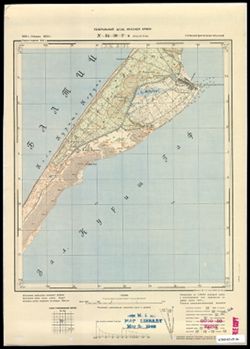
- Coordinates: 55.083, 20.75, 55.167, 20.875
- Related URL:
- Catalog URL: https://iucat.iu.edu/catalog/14701157 and Download GeoTIFF: https://drive.google.com/file/d/1JlpkAjeRU6ZM55Ej_M3cn9jjp0fom93V/view?usp=sharing
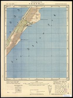
- Abstract:
- Modern area represented: Rybachiy, Kaliningrad oblast, Russia
- Call Number:
- G7063.K2 s25 .S6 sheet N-34-30-D-a
- City:
- Росситтен (Rossitten)
- Copyright Holder:
- No Copyright - United States
- Country:
- Германия (Germany) and Восточная Пруссия (East Prussia)
- Physical Description:
- Scale: 1:25,000
- Persistent URL:
- http://purl.dlib.indiana.edu/iudl/images/VAC9619/VAC9619-003590
- Provenance:
- M. I. Map Library, G000-30, GS, RA
-
- Subject:
- Topical Subject: Soviet Union, Geographic Subject: Mys Ptichiy, and Topical Subject: Maps
- Publisher:
- Генеральный штаб РККА
- Language:
- Russian
- Date Created:
- 1940
- Identifier:
- VAC9619-003589
- Genre:
- Topographic Maps and Military Maps
- Geographic Location:
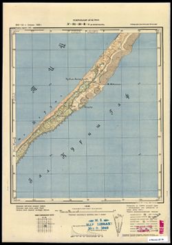
- Coordinates: 55, 20.625, 55.083, 20.75
- Related URL:
- Catalog URL: https://iucat.iu.edu/catalog/14701157 and Download GeoTIFF: https://drive.google.com/file/d/15WicBKNE8MRo4-2lVtS2fC8rJy6hMY_M/view?usp=sharing
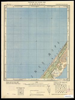
- Abstract:
- Modern area represented: Mys Ptichiy, Kaliningrad oblast, Russia
- Call Number:
- G7063.K2 s25 .S6 sheet N-34-30-C-d
- City:
- Мевенхакен
- Copyright Holder:
- No Copyright - United States
- Country:
- Восточная Пруссия (East Prussia) and Германия (Germany)
- Physical Description:
- Scale: 1:25,000
- Persistent URL:
- http://purl.dlib.indiana.edu/iudl/images/VAC9619/VAC9619-003589
- Provenance:
- M. I. Map Library, G000-30, GS, RA
-
- Subject:
- Topical Subject: Soviet Union, Geographic Subject: Lesnoy, and Topical Subject: Maps
- Publisher:
- Генеральный штаб РККА
- Language:
- Russian
- Date Created:
- 1940
- Identifier:
- VAC9619-003588
- Genre:
- Military Maps and Topographic Maps
- Geographic Location:
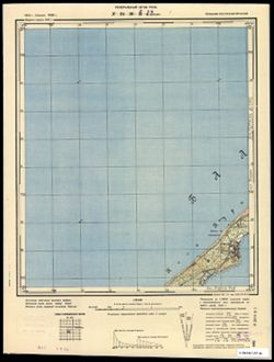
- Coordinates: 55, 20.5, 55.083, 20.625
- Related URL:
- Catalog URL: https://iucat.iu.edu/catalog/14701157 and Download GeoTIFF: https://drive.google.com/file/d/1iAyyaQlcH3PgnIB6KJJKHwl0iTJ-n3-D/view?usp=sharing
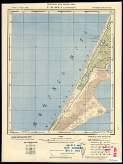
- Abstract:
- Modern area represented: Lesnoy, Kaliningrad oblast, Russia
- Call Number:
- G7063.K2 s25 .S6 sheet N-34-30-C-c
- City:
- Заркау (Zarkau)
- Copyright Holder:
- No Copyright - United States
- Country:
- Германия (Germany) and Восточная Пруссия (East Prussia)
- Physical Description:
- Scale: 1:25,000
- Persistent URL:
- http://purl.dlib.indiana.edu/iudl/images/VAC9619/VAC9619-003588
- Provenance:
- CIA Map Branch -- Received, G000-30
-
- Description:
- 1912
- Subject:
- Topical Subject: Soviet Union and Topical Subject: Maps
- Publisher:
- Генеральный штаб Красной Армии
- Language:
- Russian
- Date Created:
- 1940
- Identifier:
- VAC9619-003587
- Genre:
- Military Maps and Topographic Maps
- Geographic Location:
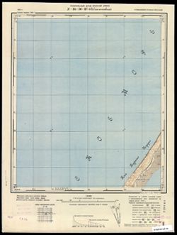
- Coordinates: 55.083, 20.625, 55.167, 20.75
- Related URL:
- Download GeoTIFF: https://drive.google.com/file/d/1so0g2PTFh3q_dU1hTXnqvi3FX660pmNL/view?usp=sharing and Catalog URL: https://iucat.iu.edu/catalog/14701157
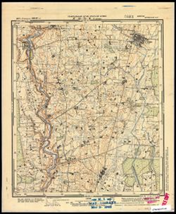
- Abstract:
- Modern area represented: Curonian Spit, Kaliningrad oblast, Russia
- Call Number:
- G7063.K2 s25 .S6 sheet N-34-30-C-b
- City:
- Ной Ляттенвальде (Noi Lyatteval'de)
- Copyright Holder:
- No Copyright - United States
- Country:
- Восточная Пруссия (East Prussia) and Германия (Germany)
- Physical Description:
- Scale: 1:25,000
- Persistent URL:
- http://purl.dlib.indiana.edu/iudl/images/VAC9619/VAC9619-003587
- Provenance:
- CIA Map Branch -- Received, G000-30
-
- Subject:
- Topical Subject: Soviet Union, Topical Subject: Maps, and Geographic Subject: Morskoye
- Publisher:
- Генеральный штаб РККА
- Language:
- Russian
- Date Created:
- 1940
- Identifier:
- VAC9619-003586
- Genre:
- Military Maps and Topographic Maps
- Geographic Location:
- Coordinates: 55.167, 20.875, 55.25, 21
- Related URL:
- Catalog URL: https://iucat.iu.edu/catalog/14701157 and Download GeoTIFF: https://drive.google.com/file/d/1Rsb9vB0P3JuEDMdk-KNbVt1oSoBEfUAp/view?usp=sharing
- Abstract:
- Modern area represented: Morskoye, Kaliningrad oblast, Russia
- Call Number:
- G7063.K2 s25 .S6 sheet N-34-30-B-d
- City:
- Пиллкоппен (Pillkoppen)
- Copyright Holder:
- No Copyright - United States
- Country:
- Восточная Пруссия (East Prussia) and Германия (Germany)
- Physical Description:
- Scale: 1:25,000
- Persistent URL:
- http://purl.dlib.indiana.edu/iudl/images/VAC9619/VAC9619-003586
- Provenance:
- CIA Map Branch -- Received, G000-30
-
- Description:
- 1910
- Subject:
- Geographic Subject: Gora Vyshka, Topical Subject: Soviet Union, and Topical Subject: Maps
- Publisher:
- Генеральный штаб Красной Армии
- Language:
- Russian
- Date Created:
- 1940
- Identifier:
- VAC9619-003585
- Genre:
- Topographic Maps and Military Maps
- Geographic Location:
- Coordinates: 55.167, 20.75, 55.25, 20.875
- Related URL:
- Download GeoTIFF: https://drive.google.com/file/d/1Kewy2gfGiTYuXyDWBAycNeLEZU9U5CiW/view?usp=sharing and Catalog URL: https://iucat.iu.edu/catalog/14701157
- Abstract:
- Modern area represented: Gora Vyshka, Kaliningrad oblast, Russia
- Call Number:
- G7063.K2 s25 .S6 sheet N-34-30-B-c
- City:
- Предин-Берг (Predinberg)
- Copyright Holder:
- No Copyright - United States
- Country:
- Германия (Germany) and Восточная Пруссия (East Prussia)
- Physical Description:
- Scale: 1:25,000
- Persistent URL:
- http://purl.dlib.indiana.edu/iudl/images/VAC9619/VAC9619-003585
- Provenance:
- CIA Map Branch -- Received, G000-30
-
- Subject:
- Topical Subject: Maps, Geographic Subject: Pamidžio Kopa, and Topical Subject: Soviet Union
- Publisher:
- Генеральный штаб Красной Армии
- Language:
- Russian
- Date Created:
- 1940
- Identifier:
- VAC9619-003584
- Genre:
- Topographic Maps and Military Maps
- Geographic Location:
- Coordinates: 55.25, 20.875, 55.333, 21
- Related URL:
- Catalog URL: https://iucat.iu.edu/catalog/14701157 and Download GeoTIFF: https://drive.google.com/file/d/1m1V0SGipIy0sho-kOLoS7Kg7F_lr0UDu/view?usp=sharing
- Abstract:
- Modern area represented: Pamidžio Kopa, Lithuania
- Call Number:
- G7063.K2 s25 .S6 sheet N-34-30-B-b
- City:
- Парниденер-Берг (Parnidener-Berg)
- Copyright Holder:
- No Copyright - United States
- Country:
- Германия (Восточная Пруссия) (Germany (East Prussia))
- Physical Description:
- Scale: 1:25,000
- Persistent URL:
- http://purl.dlib.indiana.edu/iudl/images/VAC9619/VAC9619-003584
- Provenance:
- M. I. Map Library
-
- Subject:
- Geographic Subject: Krakės, Topical Subject: Soviet Union, and Topical Subject: Maps
- Publisher:
- Генеральный штаб Красной Армии
- Language:
- Russian
- Date Created:
- 1941
- Identifier:
- VAC9619-003583
- Genre:
- Topographic Maps and Military Maps
- Geographic Location:
- Coordinates: 55.333, 23.625, 55.417, 23.75
- Related URL:
- Download GeoTIFF: https://drive.google.com/file/d/19Cr2qI4RqBkehkyBa1nvsuagjpFFQlbF/view?usp=sharing and Catalog URL: https://iucat.iu.edu/catalog/14701157
- Abstract:
- Modern area represented: Krakės, Lithuania
- Call Number:
- G7063.K2 s25 .S6 sheet N-34-24-C-d
- Caption:
- Секретно
- City:
- Кроки (Kroki)
- Copyright Holder:
- No Copyright - United States
- Country:
- СССР (USSR)
- State/Province:
- Литовская ССР (Lithuanian Soviet Socialist Republic)
- Physical Description:
- Scale: 1:25,000
- Persistent URL:
- http://purl.dlib.indiana.edu/iudl/images/VAC9619/VAC9619-003583
- Provenance:
- M. I. Map Library
-
- Subject:
- Topical Subject: Soviet Union, Geographic Subject: Stankiškiai, and Topical Subject: Maps
- Publisher:
- Генеральный штаб Красной Армии
- Language:
- Russian
- Date Created:
- 1940
- Identifier:
- VAC9619-003581
- Genre:
- Military Maps and Topographic Maps
- Geographic Location:
- Coordinates: 55.333, 21.125, 55.417, 21.25
- Related URL:
- Download GeoTIFF: https://drive.google.com/file/d/1WzLj-J4h1Zg1dRJmjt0QaBh4uQl8gFRm/view?usp=sharing and Catalog URL: https://iucat.iu.edu/catalog/14701157
- Abstract:
- Modern area represented: Stankiškiai, Lithuania
- Call Number:
- G7063.K2 s25 .S6 sheet N-34-19-C-d
- Caption:
- Captured map
- City:
- Станкишкен (Stankishken)
- Copyright Holder:
- No Copyright - United States
- Country:
- Германия (Восточная Пруссия) (Germany (East Prussia))
- Physical Description:
- Scale: 1:25,000
- Persistent URL:
- http://purl.dlib.indiana.edu/iudl/images/VAC9619/VAC9619-003581
- Provenance:
- Army Map Service Library
-
- Subject:
- Topical Subject: Maps, Geographic Subject: Vainutas, and Topical Subject: Soviet Union
- Publisher:
- Генеральный штаб Красной Армии
- Language:
- Russian
- Date Created:
- 1941
- Identifier:
- VAC9619-003582
- Genre:
- Military Maps and Topographic Maps
- Geographic Location:
- Coordinates: 55.333, 21.75.55.417, 21.875
- Related URL:
- Catalog URL: https://iucat.iu.edu/catalog/14701157 and Download GeoTIFF: https://drive.google.com/file/d/1aErZ1E3URLkUL0l3JLJBTc4Fn8K13Dpn/view?usp=sharing
- Abstract:
- Modern area represented: Vainutas, Lithuania
- Call Number:
- G7063.K2 s25 .S6 sheet N-34-20-D-c
- Caption:
- Секретно
- City:
- Войнуты (Voinuty)
- Copyright Holder:
- No Copyright - United States
- Country:
- СССР (USSR)
- State/Province:
- Литовская ССР (Lithuanian Soviet Socialist Republic)
- Physical Description:
- Scale: 1:25,000
- Persistent URL:
- http://purl.dlib.indiana.edu/iudl/images/VAC9619/VAC9619-003582
- Provenance:
- CIA Map Branch -- Received
