
Search Constraints
You searched for:
Holding Location
B-WELLS
Remove constraint Holding Location: B-WELLS
Provenance
DMA Topographic Center, Army Map Service Library, OMAHA, Library of Congress Geography & Map Division
Remove constraint Provenance: DMA Topographic Center, Army Map Service Library, OMAHA, Library of Congress Geography & Map Division
« Previous |
1 - 100 of 904
|
Next »
Search Results
-
- Description:
- 1938
- Subject:
- Topical Subject: Soviet Union, Topical Subject: Maps, and Geographic Subject: Gorshkovo
- Publisher:
- Главное Управление Геодезии и Картографии при СНК СССР
- Language:
- Russian
- Date Created:
- 1941
- Identifier:
- VAC9619-001600
- Genre:
- Military Maps and Topographic Maps
- Geographic Location:
- Coordinates: 54.3333, 37.75, 54.5, 38
- Related URL:
- Download GeoTIFF: https://drive.google.com/open?id=1n5OJOuYUDbObh4psLn6H0cDRB7jPil10 and Catalog URL: http://iucat.iu.edu/catalog/5020131
- Abstract:
- Modern area represented: Gorshkovo, Tula oblast, Russia
- Call Number:
- G7000 s50 .S68 sheet N-37-52-Г
- City:
- Горшково (Gorshkovo)
- Copyright Holder:
- No Copyright - United States
- Country:
- СССР (USSR)
- State/Province:
- РСФСР (RSFSR) and Тульская область (Tula oblast)
- Physical Description:
- Scale: 1:50,000
- Persistent URL:
- http://purl.dlib.indiana.edu/iudl/images/VAC9619/VAC9619-001600
- Provenance:
- DMA Topographic Center, Army Map Service Library, OMAHA, Library of Congress Geography & Map Division
-
- Description:
- 1938
- Subject:
- Topical Subject: Maps, Geographic Subject: Laptevo, and Topical Subject: Soviet Union
- Publisher:
- Главное Управление Геодезии и Картографии при СНК СССР
- Language:
- Russian
- Date Created:
- 1941
- Identifier:
- VAC9619-001598
- Genre:
- Military Maps and Topographic Maps
- Geographic Location:
- Coordinates: 54.3333, 37.5, 54.5, 37.75
- Related URL:
- Download GeoTIFF: https://drive.google.com/open?id=1jVqSWj3avGDHX-ZeBo8XOwnk6HPHPUR3 and Catalog URL: http://iucat.iu.edu/catalog/5020131
- Abstract:
- Moder area represented: Laptevo, Tula oblast, Russia
- Call Number:
- G7000 s50 .S68 sheet N-37-52-B
- City:
- Лаптево (Laptevo)
- Copyright Holder:
- No Copyright - United States
- Country:
- СССР (USSR)
- State/Province:
- Тульская область (Tula oblast) and РСФСР (RSFSR)
- Physical Description:
- Scale: 1:50,000
- Persistent URL:
- http://purl.dlib.indiana.edu/iudl/images/VAC9619/VAC9619-001598
- Provenance:
- DMA Topographic Center, Army Map Service Library, OMAHA, Library of Congress Geography & Map Division
-
- Description:
- 1938
- Subject:
- Topical Subject: Maps, Geographic Subject: Mokraya Kor, and Topical Subject: Soviet Union
- Publisher:
- Главное Управление Геодезии и Картографии при СНК СССР
- Language:
- Russian
- Date Created:
- 1941
- Identifier:
- VAC9619-001597
- Genre:
- Military Maps and Topographic Maps
- Geographic Location:
- Coordinates: 54.5, 37.75, 54.6667, 38
- Related URL:
- Download GeoTIFF: https://drive.google.com/open?id=1gffQELAjTu3MBlbTHyYP8PMSKwWWqeE2 and Catalog URL: http://iucat.iu.edu/catalog/5020131
- Abstract:
- Modern area represented: Mokraya Kor, Tula oblast, Russia
- Call Number:
- G7000 s50 .S68 sheet N-37-52-B
- City:
- Мокрая Корь (Mokraya Kor)
- Copyright Holder:
- No Copyright - United States
- Country:
- СССР (USSR)
- State/Province:
- Тульская область (Tula oblast) and РСФСР (RSFSR)
- Physical Description:
- Scale: 1:50,000
- Persistent URL:
- http://purl.dlib.indiana.edu/iudl/images/VAC9619/VAC9619-001597
- Provenance:
- DMA Topographic Center, Army Map Service Library, OMAHA, Library of Congress Geography & Map Division
-
- Description:
- 1938
- Subject:
- Geographic Subject: Nikiforovo, Topical Subject: Maps, and Topical Subject: Soviet Union
- Publisher:
- Главное Управление Геодезии и Картографии при СНК СССР
- Language:
- Russian
- Date Created:
- 1941
- Identifier:
- VAC9619-001596
- Genre:
- Topographic Maps and Military Maps
- Geographic Location:
- Coordinates: 54.833, 37.5, 55, 37.75
- Related URL:
- Catalog URL: http://iucat.iu.edu/catalog/5020131 and Download GeoTIFF: https://drive.google.com/open?id=1El5NA8PIkjw7gec-UlLvip8MP0uFlYEF
- Abstract:
- Modern area represented: Nikiforovo, Moscow oblast, Russia
- Call Number:
- G7000 s50 .S68 sheet N-37-40-A
- City:
- Никифорово (Nikiforovo)
- Copyright Holder:
- No Copyright - United States
- Country:
- СССР (USSR)
- State/Province:
- РСФСР (RSFSR), Московская область (Moscow oblast), and Тульская область (Tula oblast)
- Physical Description:
- Scale: 1:50,000
- Persistent URL:
- http://purl.dlib.indiana.edu/iudl/images/VAC9619/VAC9619-001596
- Provenance:
- DMA Topographic Center, Army Map Service Library, OMAHA, Library of Congress Geography & Map Division
-
- Description:
- 1927
- Subject:
- Geographic Subject: Kurovskoye, Topical Subject: Soviet Union, and Topical Subject: Maps
- Publisher:
- Главный Геодезический Комитет
- Language:
- Russian
- Identifier:
- VAC9619-001592
- Genre:
- Topographic Maps and Military Maps
- Geographic Location:
- Coordinates: 55.5, 38.75, 55.6667, 39
- Related URL:
- Download GeoTIFF: https://drive.google.com/open?id=1PCPLpNhalxc-K3di2FF8ZgGX5bcUdweA and Catalog URL: http://iucat.iu.edu/catalog/5020131
- Abstract:
- Modern area represented: Kurovskoye, Moscow oblast, Russia
- Call Number:
- G7000 s50 .S68 sheet N-37-18-Б
- City:
- Куровская (Kurovskaya)
- Copyright Holder:
- No Copyright - United States
- Country:
- СССР (USSR)
- State/Province:
- Московская область (Moscow oblast) and РСФСР (RSFSR)
- Physical Description:
- Scale: 1:50,000
- Persistent URL:
- http://purl.dlib.indiana.edu/iudl/images/VAC9619/VAC9619-001592
- Provenance:
- DMA Topographic Center, Army Map Service Library, OMAHA, Library of Congress Geography & Map Division
-
- Description:
- 1938
- Subject:
- Geographic Subject: Vereya, Topical Subject: Soviet Union, and Topical Subject: Maps
- Publisher:
- Главное Управление Геодезии и Картографии при СНК СССР
- Language:
- Russian
- Date Created:
- 1941
- Identifier:
- VAC9619-001590
- Genre:
- Topographic Maps and Military Maps
- Geographic Location:
- Coordinates: 55.3333, 36, 55.5, 36.25
- Related URL:
- Download GeoTIFF: https://drive.google.com/open?id=1wBMla9XTlKS1xoCxrPqhKu9J0XdbhkEc and Catalog URL: http://iucat.iu.edu/catalog/5020131
- Abstract:
- Modern area represented: Vereya, Moscow oblast, Russia
- Call Number:
- G7000 s50 .S68 sheet N-37-13-C
- Copyright Holder:
- No Copyright - United States
- Country:
- СССР (USSR)
- State/Province:
- РСФСР (RSFSR) and Московская область (Moscow oblast)
- Physical Description:
- Scale: 1:50,000
- Persistent URL:
- http://purl.dlib.indiana.edu/iudl/images/VAC9619/VAC9619-001590
- Provenance:
- DMA Topographic Center, Army Map Service Library, OMAHA, Library of Congress Geography & Map Division
-
- Description:
- 1938
- Subject:
- Topical Subject: Maps, Topical Subject: Soviet Union, and Geographic Subject: Dorokhovo
- Publisher:
- Главное Управление Геодезии и Картографии при СНК СССР
- Language:
- Russian
- Date Created:
- 1941
- Identifier:
- VAC9619-001589
- Genre:
- Topographic Maps and Military Maps
- Geographic Location:
- Coordinates: 55.5, 36.25, 55.6667, 36.5
- Related URL:
- Catalog URL: http://iucat.iu.edu/catalog/5020131 and Download GeoTIFF: https://drive.google.com/open?id=1ae8VatKg7mKS3Ot_8Hz2EdxDA5_NzAMs
- Abstract:
- Modern area represented: Dorokhovo, Moscow oblast, Russia
- Call Number:
- G7000 s50 .S68 sheet N-37-13-Б
- City:
- Дорохово (Dorokhovo)
- Copyright Holder:
- No Copyright - United States
- Country:
- СССР (USSR)
- State/Province:
- РСФСР (RSFSR) and Московская область (Moscow oblast)
- Physical Description:
- Scale: 1:50,000
- Persistent URL:
- http://purl.dlib.indiana.edu/iudl/images/VAC9619/VAC9619-001589
- Provenance:
- DMA Topographic Center, Army Map Service Library, OMAHA, Library of Congress Geography & Map Division
-
- Description:
- 1922
- Subject:
- Topical Subject: Maps, Topical Subject: Soviet Union, and Geographic Subject: Orekhovo-Zuyevo
- Publisher:
- Геодезический комитет ВСНХ-СССР
- Language:
- Russian
- Date Created:
- 1925
- Identifier:
- VAC9619-001587
- Genre:
- Topographic Maps and Military Maps
- Geographic Location:
- Coordinates: 55.6667, 38.75, 55.8333, 39
- Related URL:
- Catalog URL: http://iucat.iu.edu/catalog/5020131 and Download GeoTIFF: https://drive.google.com/open?id=1YSoC4qULp6BdN-5c-DqfZ7rEYz_wNjk4
- Abstract:
- Modern area represented: Orekhovo-Zuyevo, Moscow oblast, Russia
- Call Number:
- G7000 s50 .S68 sheet N-37-6-Г
- City:
- Орехово-Зуево (Orekhovo-Zuyevo)
- Copyright Holder:
- No Copyright - United States
- Country:
- СССР (USSR)
- State/Province:
- Московская область (Moscow oblast) and РСФСР (RSFSR)
- Physical Description:
- Scale: 1:50,000
- Persistent URL:
- http://purl.dlib.indiana.edu/iudl/images/VAC9619/VAC9619-001587
- Provenance:
- DMA Topographic Center, Army Map Service Library, OMAHA, Library of Congress Geography & Map Division
-
- Description:
- 1922
- Subject:
- Geographic Subject: Pavlovskaya Sloboda, Topical Subject: Soviet Union, and Topical Subject: Maps
- Publisher:
- Главное геодезическое управление
- Language:
- Russian
- Date Created:
- 1925
- Identifier:
- VAC9619-001585
- Genre:
- Topographic Maps and Military Maps
- Geographic Location:
- Coordinates: 55.6667, 37, 55.8667, 37.25
- Related URL:
- Download GeoTIFF: https://drive.google.com/open?id=19y6_pc0fOC1JCk_Asjh7Xv3p2fRVcApN and Catalog URL: http://iucat.iu.edu/catalog/5020131
- Abstract:
- Modern area represented: Pavlovskaya Sloboda, Moscow oblast, Russia
- Call Number:
- G7000 s50 .S68 sheet N-37-3-C
- City:
- Павловская Слобода (Pavlovskaya Sloboda)
- Copyright Holder:
- No Copyright - United States
- Country:
- СССР (USSR)
- State/Province:
- Московская область (Moscow oblast) and РСФСР (RSFSR)
- Physical Description:
- Scale: 1:50,000
- Persistent URL:
- http://purl.dlib.indiana.edu/iudl/images/VAC9619/VAC9619-001585
- Provenance:
- DMA Topographic Center, Army Map Service Library, OMAHA, Library of Congress Geography & Map Division
-
- Description:
- 1940
- Subject:
- Geographic Subject: Kokorevka, Topical Subject: Soviet Union, and Topical Subject: Maps
- Publisher:
- Главное Управление Геодезии и Картографии при СНК СССР
- Language:
- Russian
- Date Created:
- 1941
- Identifier:
- VAC9619-001561
- Genre:
- Military Maps and Topographic Maps
- Geographic Location:
- Coordinates: 52.5, 34.25, 52.6667, 34.5
- Related URL:
- Catalog URL: http://iucat.iu.edu/catalog/5020131 and Download GeoTIFF: https://drive.google.com/open?id=1aCIFWOLZoer3DkKzSR6t75p6d6aOZN2J
- Abstract:
- Modern area represented: Kokorevka, Bryansk oblast, Russia
- Call Number:
- G7000 s50 .S68 sheet N-36-129-B
- City:
- Кокоревка (Kokorevka)
- Copyright Holder:
- No Copyright - United States
- Country:
- СССР (USSR)
- State/Province:
- Орловская область (Oryol oblast) and РСФСР (RSFSR)
- Physical Description:
- Scale: 1:50,000
- Persistent URL:
- http://purl.dlib.indiana.edu/iudl/images/VAC9619/VAC9619-001561
- Provenance:
- DMA Topographic Center, Army Map Service Library, OMAHA, Library of Congress Geography & Map Division
-
- Description:
- 1930
- Subject:
- Topical Subject: Soviet Union, Topical Subject: Maps, and Geographic Subject: Pervomayskoye
- Publisher:
- Генеральный штаб Красной Армии
- Language:
- Russian
- Date Created:
- 1934
- Identifier:
- VAC9619-001544
- Genre:
- Topographic Maps and Military Maps
- Geographic Location:
- Coordinates: 52.8667, 33.5, 53, 33.75
- Related URL:
- Download GeoTIFF: https://drive.google.com/open?id=1jvWuFAQ4n_nl6IkEGFq_87wHlKtMxVO5 and Catalog URL: http://iucat.iu.edu/catalog/5020131
- Abstract:
- Modern area represented: Pervomayskoye, Bryansk oblast, Russia
- Call Number:
- G7000 s50 .S68 sheet N-36-116-A
- City:
- Пьяный Рог (Pyany Rog)
- Copyright Holder:
- No Copyright - United States
- Country:
- СССР (USSR)
- State/Province:
- РСФСР (RSFSR) and Орловская область (Oryol oblast)
- Physical Description:
- Scale: 1:50,000
- Persistent URL:
- http://purl.dlib.indiana.edu/iudl/images/VAC9619/VAC9619-001544
- Provenance:
- DMA Topographic Center, Army Map Service Library, OMAHA, Library of Congress Geography & Map Division
-
- Description:
- 1931
- Subject:
- Topical Subject: Soviet Union, Topical Subject: Maps, and Geographic Subject: Korzhovka-Golubovka
- Publisher:
- Управление военных топографов
- Language:
- Russian
- Identifier:
- VAC9619-001539
- Genre:
- Topographic Maps and Military Maps
- Geographic Location:
- Coordinates: 52.6667, 32.25, 52.8667, 32.5
- Related URL:
- Catalog URL: http://iucat.iu.edu/catalog/5020131 and Download GeoTIFF: https://drive.google.com/open?id=1caz06yDhenOXRJOAcQZ0f7DQYtkJfycT
- Abstract:
- Modern area represented: Korzhovka-Golubovka, Bryansk oblast, Russia
- Call Number:
- G7000 s50 .S68 sheet N-36-113-D
- Caption:
- Временное издание,Не подлежит оглашению
- City:
- Коржовка-Голубовка (Korzhovka-Golubovka)
- Copyright Holder:
- No Copyright - United States
- Country:
- СССР (USSR)
- State/Province:
- РСФСР (RSFSR) and Западная область (Western oblast)
- Physical Description:
- Scale: 1:50,000
- Persistent URL:
- http://purl.dlib.indiana.edu/iudl/images/VAC9619/VAC9619-001539
- Provenance:
- DMA Topographic Center, Army Map Service Library, OMAHA, Library of Congress Geography & Map Division
-
- Description:
- 1923
- Subject:
- Topical Subject: Maps, Topical Subject: Soviet Union, and Geographic Subject: Neglyubka
- Publisher:
- Военно-топографическое управление
- Language:
- Russian
- Identifier:
- VAC9619-001537
- Genre:
- Military Maps and Topographic Maps
- Geographic Location:
- Coordinates: 52.6667, 31.5, 52.8667, 31.75
- Related URL:
- Catalog URL: http://iucat.iu.edu/catalog/5020131 and Download GeoTIFF: https://drive.google.com/open?id=19Zzi7_T_u2t3c_mQLJy93SKzIE78_JVV
- Abstract:
- Modern area represented: Neglyubka, Homyel oblast, Belarus
- Call Number:
- G7000 s50 .S68 sheet N-36-112-D
- Caption:
- Секретно
- City:
- Неглюбка (Neglyubka)
- Copyright Holder:
- No Copyright - United States
- Country:
- СССР (USSR)
- State/Province:
- РСФСР (RSFSR), Западная область (Western oblast), and Белорусская ССР (Byelorussian Soviet Socialist Republic)
- Physical Description:
- Scale: 1:50,000
- Persistent URL:
- http://purl.dlib.indiana.edu/iudl/images/VAC9619/VAC9619-001537
- Provenance:
- DMA Topographic Center, Army Map Service Library, OMAHA, Library of Congress Geography & Map Division
-

- Description:
- 1928
- Subject:
- Topical Subject: Soviet Union, Topical Subject: Maps, and Geographic Subject: Kazatskiye Bolsuny
- Publisher:
- Военно-топографическое управление
- Language:
- Russian
- Identifier:
- VAC9619-001534
- Genre:
- Topographic Maps and Military Maps
- Geographic Location:
- Coordinates: 52.8667, 31.25, 53, 32
- Related URL:
- Catalog URL: http://iucat.iu.edu/catalog/5020131 and Download GeoTIFF: https://drive.google.com/open?id=1HkKrlIrLrwWmSzMloRMTx-XUvXR4gx4D
- Abstract:
- Modern area represented: Kazatskiye Bolsuny, Homyel oblast, Belarus
- Call Number:
- G7000 s50 .S68 sheet N-36-111-B
- Caption:
- Секретно
- City:
- Казацкие Болсуны (Kazatskiye Bolsuny)
- Copyright Holder:
- No Copyright - United States
- Country:
- СССР (USSR)
- State/Province:
- Западная область (Western oblast), Белорусская ССР (Byelorussian Soviet Socialist Republic), and РСФСР (RSFSR)
- Physical Description:
- Scale: 1:50,000
- Persistent URL:
- http://purl.dlib.indiana.edu/iudl/images/VAC9619/VAC9619-001534
- Provenance:
- DMA Topographic Center, Army Map Service Library, OMAHA, Library of Congress Geography & Map Division
-
- Description:
- 1928
- Subject:
- Topical Subject: Soviet Union, Geographic Subject: Lokot, and Topical Subject: Maps
- Publisher:
- Управление военных топографов РККА
- Language:
- Russian
- Identifier:
- VAC9619-001533
- Genre:
- Military Maps and Topographic Maps
- Geographic Location:
- Coordinates: 52.8667, 31, 53, 31.25
- Related URL:
- Download GeoTIFF: https://drive.google.com/open?id=1GxpBUovSd_cHLsCzQK6TDAseshOXH1ab and Catalog URL: http://iucat.iu.edu/catalog/5020131
- Abstract:
- Modern area represented: Lokot, Bryansk oblast, Russia
- Call Number:
- G7000 s50 .S68 sheet N-36-111-A
- Caption:
- Не подлежит оглашению
- City:
- Локоть (Lokot)
- Copyright Holder:
- No Copyright - United States
- Country:
- СССР (USSR)
- State/Province:
- Белорусская ССР (Byelorussian Soviet Socialist Republic)
- Physical Description:
- Scale: 1:50,000
- Persistent URL:
- http://purl.dlib.indiana.edu/iudl/images/VAC9619/VAC9619-001533
- Provenance:
- DMA Topographic Center, Army Map Service Library, OMAHA, Library of Congress Geography & Map Division
-
- Description:
- 1928
- Subject:
- Geographic Subject: Prisno, Topical Subject: Soviet Union, and Topical Subject: Maps
- Publisher:
- Управление военных топографов
- Language:
- Russian
- Identifier:
- VAC9619-001528
- Genre:
- Topographic Maps and Military Maps
- Geographic Location:
- Coordinates: 52.6667, 30.75, 53, 31
- Related URL:
- Catalog URL: http://iucat.iu.edu/catalog/5020131 and Download GeoTIFF: https://drive.google.com/open?id=1FXKHO5tXHr9fKZjzS1o03TiZjtGCy1Nb
- Abstract:
- Modern area represented: Prisno, Homyel oblast, Belarus
- Call Number:
- G7000 s50 .S68 sheet N-36-110-D
- Caption:
- Не подлежит оглашению
- City:
- Присно (Prisno)
- Copyright Holder:
- No Copyright - United States
- Country:
- СССР (USSR)
- State/Province:
- Белорусская ССР (Byelorussian Soviet Socialist Republic)
- Physical Description:
- Scale: 1:50,000
- Persistent URL:
- http://purl.dlib.indiana.edu/iudl/images/VAC9619/VAC9619-001528
- Provenance:
- DMA Topographic Center, Army Map Service Library, OMAHA, Library of Congress Geography & Map Division
-
- Description:
- 1940
- Subject:
- Topical Subject: Maps, Geographic Subject: Alekhino, and Topical Subject: Soviet Union
- Publisher:
- Главное Управление Геодезии и Картографии при СНК СССР
- Language:
- Russian
- Date Created:
- 1941
- Identifier:
- VAC9619-001516
- Genre:
- Topographic Maps and Military Maps
- Geographic Location:
- Coordinates: 53.1667, 35, 53.3333, 35.25
- Related URL:
- Download GeoTIFF: https://drive.google.com/open?id=1Cq4nFCMIfKx6u7dZkeCdFvA3RIKV4c5Z and Catalog URL: http://iucat.iu.edu/catalog/5020131
- Abstract:
- Modern area represented: Alekhino, Oryol oblast, Russia
- Call Number:
- G7000 s50 .S68 sheet N-36-107-A
- City:
- Алехино (Alekhino)
- Copyright Holder:
- No Copyright - United States
- Country:
- СССР (USSR)
- State/Province:
- РСФСР (RSFSR) and Орловская область (Oryol oblast)
- Physical Description:
- Scale: 1:50,000
- Persistent URL:
- http://purl.dlib.indiana.edu/iudl/images/VAC9619/VAC9619-001516
- Provenance:
- DMA Topographic Center, Army Map Service Library, OMAHA, Library of Congress Geography & Map Division
-
- Description:
- 1930
- Subject:
- Topical Subject: Soviet Union, Topical Subject: Maps, and Geographic Subject: Verkhopolye
- Publisher:
- Генеральный штаб Красной Армии
- Language:
- Russian
- Date Created:
- 1934
- Identifier:
- VAC9619-001514
- Genre:
- Topographic Maps and Military Maps
- Geographic Location:
- Coordinates: 53, 34.5, 53.1667, 34.75
- Related URL:
- Catalog URL: http://iucat.iu.edu/catalog/5020131 and Download GeoTIFF: https://drive.google.com/open?id=1w15QboP6wPbee79SikaUleyski-x_Eeq
- Abstract:
- Modern area represented: Verkhopolye, Bryansk oblast, Russia
- Call Number:
- G7000 s50 .S68 sheet N-36-106-C
- City:
- Верхополье (Verkhopolye)
- Copyright Holder:
- No Copyright - United States
- Country:
- СССР (USSR)
- State/Province:
- Орловская область (Oryol oblast) and РСФСР (RSFSR)
- Physical Description:
- Scale: 1:50,000
- Persistent URL:
- http://purl.dlib.indiana.edu/iudl/images/VAC9619/VAC9619-001514
- Provenance:
- DMA Topographic Center, Army Map Service Library, OMAHA, Library of Congress Geography & Map Division
-
- Description:
- 1931
- Subject:
- Topical Subject: Soviet Union, Topical Subject: Maps, and Geographic Subject: Bolotnya
- Publisher:
- Управление военных топографов
- Language:
- Russian
- Identifier:
- VAC9619-001504
- Genre:
- Military Maps and Topographic Maps
- Geographic Location:
- Coordinates: 53.1667, 32.75, 53.3333, 33
- Related URL:
- Download GeoTIFF: https://drive.google.com/file/d/1DND7UENKh3QT4-FNIuxE4qh94CJeHGgb/view?usp=sharing and Catalog URL: http://iucat.iu.edu/catalog/5020131
- Abstract:
- Modern area represented: Bolotnya, Bryansk oblast, Russia
- Call Number:
- G7000 s50 .S68 sheet N-36-105-B
- Caption:
- Не подлежит оглашению
- City:
- Болотня (Bolotnya)
- Copyright Holder:
- No Copyright - United States
- Country:
- СССР (USSR)
- State/Province:
- РСФСР (RSFSR) and Западная область (Western oblast)
- Physical Description:
- Scale: 1:50,000
- Persistent URL:
- http://purl.dlib.indiana.edu/iudl/images/VAC9619/VAC9619-001504
- Provenance:
- DMA Topographic Center, Army Map Service Library, OMAHA, Library of Congress Geography & Map Division
-
- Description:
- 1928
- Subject:
- Topical Subject: Maps, Geographic Subject: Perelazy, and Topical Subject: Soviet Union
- Publisher:
- Военно-топографическое управление
- Language:
- Russian
- Identifier:
- VAC9619-001492
- Genre:
- Military Maps and Topographic Maps
- Geographic Location:
- Coordinates: 53, 31.25, 53.1667, 31.5
- Related URL:
- Download GeoTIFF: https://drive.google.com/open?id=1ENiuALuDhQhhmTPCP9izmCTMfCtZ8nYe and Catalog URL: http://iucat.iu.edu/catalog/5020131
- Abstract:
- Modern area represented: Perelazy, Bryansk oblast, Russia
- Call Number:
- G7000 s50 .S68 sheet N-36-99-D
- Caption:
- Секретно
- City:
- Перелазы (Perelazy)
- Copyright Holder:
- No Copyright - United States
- Country:
- СССР (USSR)
- State/Province:
- РСФСР (RSFSR), Западная область (Western oblast), and Белорусская ССР (Byelorussian Soviet Socialist Republic)
- Physical Description:
- Scale: 1:50,000
- Persistent URL:
- http://purl.dlib.indiana.edu/iudl/images/VAC9619/VAC9619-001492
- Provenance:
- DMA Topographic Center, Army Map Service Library, OMAHA, Library of Congress Geography & Map Division
-
- Description:
- 1928
- Subject:
- Topical Subject: Maps, Topical Subject: Soviet Union, and Geographic Subject: Sidorovichi
- Publisher:
- Управление военных топографов РККА
- Language:
- Russian
- Identifier:
- VAC9619-001491
- Genre:
- Topographic Maps and Military Maps
- Geographic Location:
- Coordinates: 53, 31, 53.1667, 31.25
- Related URL:
- Download GeoTIFF: https://drive.google.com/open?id=14CtH2oyA5T83uZvToRCwUrheXc4a-Sp8 and Catalog URL: http://iucat.iu.edu/catalog/5020131
- Abstract:
- Modern area represented: Sidorovichi, Homyel oblast, Belarus
- Call Number:
- G7000 s50 .S68 sheet N-36-99-C
- Caption:
- Не подлежит оглашению
- City:
- Сидоровичи (Sidorovichi)
- Copyright Holder:
- No Copyright - United States
- Country:
- СССР (USSR)
- State/Province:
- Белорусская ССР (Byelorussian Soviet Socialist Republic)
- Physical Description:
- Scale: 1:50,000
- Persistent URL:
- http://purl.dlib.indiana.edu/iudl/images/VAC9619/VAC9619-001491
- Provenance:
- DMA Topographic Center, Army Map Service Library, OMAHA, Library of Congress Geography & Map Division
-
- Description:
- 1928
- Subject:
- Topical Subject: Maps, Geographic Subject: Mkhinichi, and Topical Subject: Soviet Union
- Publisher:
- Военно-топографическое управление
- Language:
- Russian
- Identifier:
- VAC9619-001490
- Genre:
- Topographic Maps and Military Maps
- Geographic Location:
- Coordinates: 53.1667, 31.25, 53.3333, 31.5
- Related URL:
- Download GeoTIFF: https://drive.google.com/open?id=1jQtEydII-8vbaqeMq9G233ulXq_l2Mp- and Catalog URL: http://iucat.iu.edu/catalog/5020131
- Abstract:
- Modern area represented: Mkhinichi, Mogilev, Belarus
- Call Number:
- G7000 s50 .S68 sheet N-36-99-B
- Caption:
- Секретно
- City:
- Мхиничи (Mkhinichi)
- Copyright Holder:
- No Copyright - United States
- Country:
- СССР (USSR)
- State/Province:
- Белорусская ССР (Byelorussian Soviet Socialist Republic)
- Physical Description:
- Scale: 1:50,000
- Persistent URL:
- http://purl.dlib.indiana.edu/iudl/images/VAC9619/VAC9619-001490
- Provenance:
- DMA Topographic Center, Army Map Service Library, OMAHA, Library of Congress Geography & Map Division
-
- Description:
- 1928
- Subject:
- Geographic Subject: Karma, Topical Subject: Soviet Union, and Topical Subject: Maps
- Publisher:
- Управление военных топографов РККА
- Language:
- Russian
- Identifier:
- VAC9619-001488
- Genre:
- Military Maps and Topographic Maps
- Geographic Location:
- Coordinates: 53, 30.75, 53.1667, 31
- Related URL:
- Catalog URL: http://iucat.iu.edu/catalog/5020131 and Download GeoTIFF: https://drive.google.com/open?id=1auewxECG5RQCc2MxiN6jXOxm43MRlEyj
- Abstract:
- Modern area represented: Karma, Homyel oblast, Belarus
- Call Number:
- G7000 s50 .S68 sheet N-36-98-D
- Caption:
- Не подлежит оглашению
- City:
- Корма (Korma)
- Copyright Holder:
- No Copyright - United States
- Country:
- СССР (USSR)
- State/Province:
- Белорусская ССР (Byelorussian Soviet Socialist Republic)
- Physical Description:
- Scale: 1:50,000
- Persistent URL:
- http://purl.dlib.indiana.edu/iudl/images/VAC9619/VAC9619-001488
- Provenance:
- DMA Topographic Center, Army Map Service Library, OMAHA, Library of Congress Geography & Map Division
-
- Description:
- 1928
- Subject:
- Geographic Subject: Slavnya, Topical Subject: Maps, and Topical Subject: Soviet Union
- Publisher:
- Управление военных топографов
- Language:
- Russian
- Identifier:
- VAC9619-001487
- Genre:
- Military Maps and Topographic Maps
- Geographic Location:
- Coordinates: 53.1667, 30.75, 53.3333, 31
- Related URL:
- Download GeoTIFF: https://drive.google.com/open?id=1lVT-0rzh1ByHE3fXveb63ksjcTc8r32b and Catalog URL: http://iucat.iu.edu/catalog/5020131
- Abstract:
- Modern area represented: Slavnya, Mogilev, Belarus
- Call Number:
- G7000 s50 .S68 sheet N-36-98-B
- Caption:
- Не подлежит оглашению
- City:
- Славня (Slavnya)
- Copyright Holder:
- No Copyright - United States
- Country:
- СССР (USSR)
- State/Province:
- Белорусская ССР (Byelorussian Soviet Socialist Republic)
- Physical Description:
- Scale: 1:50,000
- Persistent URL:
- http://purl.dlib.indiana.edu/iudl/images/VAC9619/VAC9619-001487
- Provenance:
- DMA Topographic Center, Army Map Service Library, OMAHA, Library of Congress Geography & Map Division
-
- Description:
- 1936
- Subject:
- Geographic Subject: Gadilovichi, Topical Subject: Maps, and Topical Subject: Soviet Union
- Publisher:
- Управление военных топографов РККА
- Language:
- Russian
- Identifier:
- VAC9619-001485
- Genre:
- Topographic Maps and Military Maps
- Geographic Location:
- Coordinates: 53, 30.25, 53.1667, 30.5
- Related URL:
- Catalog URL: http://iucat.iu.edu/catalog/5020131 and Download GeoTIFF: https://drive.google.com/open?id=1brXddhg0G6bGWPjqapYFWje60ePNOC1r
- Abstract:
- Modern area represented: Gadilovichi, Homyel oblast, Belarus
- Call Number:
- G7000 s50 .S68 sheet N-36-97-D
- Caption:
- Не подлежит оглашению
- City:
- Гадиловичи (Gadilovichi)
- Copyright Holder:
- No Copyright - United States
- Country:
- СССР (USSR)
- State/Province:
- Белорусская ССР (Byelorussian Soviet Socialist Republic)
- Physical Description:
- Scale: 1:50,000
- Persistent URL:
- http://purl.dlib.indiana.edu/iudl/images/VAC9619/VAC9619-001485
- Provenance:
- DMA Topographic Center, Army Map Service Library, OMAHA, Library of Congress Geography & Map Division
-
- Description:
- 1936
- Subject:
- Topical Subject: Soviet Union, Geographic Subject: Zvonets, and Topical Subject: Maps
- Publisher:
- Управление военных топографов РККА
- Language:
- Russian
- Identifier:
- VAC9619-001482
- Genre:
- Military Maps and Topographic Maps
- Geographic Location:
- Coordinates: 53.1667, 30.25, 53.3333, 30.5
- Related URL:
- Download GeoTIFF: https://drive.google.com/open?id=1r2DMZh2mjVq3AyPIe8qc-uOASC2UD_rt and Catalog URL: http://iucat.iu.edu/catalog/5020131
- Abstract:
- Modern area represented: Zvonets, Homyel oblast, Belarus
- Call Number:
- G7000 s50 .S68 sheet N-36-97-B
- Caption:
- Не подлежит оглашению
- City:
- Звонец (Zvonets)
- Copyright Holder:
- No Copyright - United States
- Country:
- СССР (USSR)
- State/Province:
- Белорусская ССР (Byelorussian Soviet Socialist Republic)
- Physical Description:
- Scale: 1:50,000
- Persistent URL:
- http://purl.dlib.indiana.edu/iudl/images/VAC9619/VAC9619-001482
- Provenance:
- DMA Topographic Center, Army Map Service Library, OMAHA, Library of Congress Geography & Map Division
-
- Description:
- 1940
- Subject:
- Topical Subject: Maps, Geographic Subject: Lovat, and Topical Subject: Soviet Union
- Publisher:
- Главное Управление Геодезии и Картографии при СНК СССР
- Language:
- Russian
- Date Created:
- 1941
- Identifier:
- VAC9619-001469
- Genre:
- Topographic Maps and Military Maps
- Geographic Location:
- Coordinates: 53.5, 35, 53.6667, 35.25
- Related URL:
- Catalog URL: http://iucat.iu.edu/catalog/5020131 and Download GeoTIFF: https://drive.google.com/open?id=1CW7q_WmzCjxXip6vtnCVNXn4ufl3e4Yl
- Abstract:
- Modern area represented: Lovat, Kaluga, Russia
- Call Number:
- G7000 s50 .S68 sheet N-36-95-A
- Caption:
- Для служебного пользования
- City:
- Ловать (Lovat)
- Copyright Holder:
- No Copyright - United States
- Country:
- СССР (USSR)
- State/Province:
- Орловская область (Oryol oblast), РСФСР (RSFSR), and Смоленская область (Smolensk oblast)
- Physical Description:
- Scale: 1:50,000
- Persistent URL:
- http://purl.dlib.indiana.edu/iudl/images/VAC9619/VAC9619-001469
- Provenance:
- DMA Topographic Center, Army Map Service Library, OMAHA, Library of Congress Geography & Map Division
-
- Description:
- 1930
- Subject:
- Geographic Subject: Boyanovichi, Topical Subject: Maps, and Topical Subject: Soviet Union
- Publisher:
- Генеральный штаб РККА
- Language:
- Russian
- Identifier:
- VAC9619-001468
- Genre:
- Military Maps and Topographic Maps
- Geographic Location:
- Coordinates: 53.3333, 34.75, 53.5, 35
- Related URL:
- Catalog URL: http://iucat.iu.edu/catalog/5020131 and Download GeoTIFF: https://drive.google.com/open?id=1DREx2N3APY6G30YlAAt889SzguoUBH-8
- Abstract:
- Modern area represented: Boyanovichi, Kaluga, Russia
- Call Number:
- G7000 s50 .S68 sheet N-36-94-D
- City:
- Буяновичи (Boyanovichi)
- Copyright Holder:
- No Copyright - United States
- Country:
- СССР (USSR)
- State/Province:
- РСФСР (RSFSR) and Западная область (Western oblast)
- Physical Description:
- Scale: 1:50,000
- Persistent URL:
- http://purl.dlib.indiana.edu/iudl/images/VAC9619/VAC9619-001468
- Provenance:
- DMA Topographic Center, Army Map Service Library, OMAHA, Library of Congress Geography & Map Division
-
- Description:
- 1930
- Subject:
- Geographic Subject: Ogor, Topical Subject: Soviet Union, and Topical Subject: Maps
- Publisher:
- Генеральный штаб РККА
- Language:
- Russian
- Identifier:
- VAC9619-001467
- Genre:
- Military Maps and Topographic Maps
- Geographic Location:
- Coordinates: 53.3333, 34.5, 53.5, 34.75
- Related URL:
- Download GeoTIFF: https://drive.google.com/open?id=1z8Szky-2BN4VYpKe91aBjVJdTlFW2w8J and Catalog URL: http://iucat.iu.edu/catalog/5020131
- Abstract:
- Modern area represented: Ogor, Kaluga, Russia
- Call Number:
- G7000 s50 .S68 sheet N-36-94-C
- City:
- Огорь (Ogor)
- Copyright Holder:
- No Copyright - United States
- Country:
- СССР (USSR)
- State/Province:
- РСФСР (RSFSR) and Западная область (Western oblast)
- Physical Description:
- Scale: 1:50,000
- Persistent URL:
- http://purl.dlib.indiana.edu/iudl/images/VAC9619/VAC9619-001467
- Provenance:
- DMA Topographic Center, Army Map Service Library, OMAHA, Library of Congress Geography & Map Division
-
- Description:
- 1890
- Subject:
- Topical Subject: Soviet Union, Topical Subject: Maps, and Geographic Subject: Turda
- Publisher:
- Генеральный штаб РККА
- Language:
- Russian
- Date Created:
- 1892
- Identifier:
- VAC9619-001460
- Genre:
- Topographic Maps and Military Maps
- Geographic Location:
- Coordinates: 46.3333, 23.5, 46.6667, 24
- Related URL:
- Catalog URL: https://iucat.iu.edu/catalog/5020129 and Download GeoTIFF: https://drive.google.com/open?id=1AdXHNGR8ysvlhT9EGZhMVIvBCtdnX1DM
- Abstract:
- Modern area represented: Turda, Cluj county, Romania
- Call Number:
- G7000 s100 .S7 sheet L-34-60
- City:
- Турда (Turda)
- Copyright Holder:
- No Copyright - United States
- Country:
- Румыния (Romania)
- Physical Description:
- Scale: 1:100,000
- Persistent URL:
- http://purl.dlib.indiana.edu/iudl/images/VAC9619/VAC9619-001460
- Provenance:
- DMA Topographic Center, Army Map Service Library, OMAHA, Library of Congress Geography & Map Division
-
- Description:
- 1930
- Subject:
- Geographic Subject: Dorozhovo, Topical Subject: Soviet Union, and Topical Subject: Maps
- Publisher:
- Генеральный штаб РККА
- Language:
- Russian
- Identifier:
- VAC9619-001458
- Genre:
- Topographic Maps and Military Maps
- Geographic Location:
- Coordinates: 53.3333, 34, 53.5, 34.25
- Related URL:
- Catalog URL: http://iucat.iu.edu/catalog/5020131 and Download GeoTIFF: https://drive.google.com/open?id=1BYCAZEWtRh1BqxrBTrB9jFx29DVLXjx5
- Abstract:
- Modern area represented: Dorozhovo, Bryansk oblast, Russia
- Call Number:
- G7000 s50 .S68 sheet N-36-93-C
- City:
- Дорожова (Dorozhovo)
- Copyright Holder:
- No Copyright - United States
- Country:
- СССР (USSR)
- State/Province:
- Западная область (Western oblast) and РСФСР (RSFSR)
- Physical Description:
- Scale: 1:50,000
- Persistent URL:
- http://purl.dlib.indiana.edu/iudl/images/VAC9619/VAC9619-001458
- Provenance:
- DMA Topographic Center, Army Map Service Library, OMAHA, Library of Congress Geography & Map Division
-
- Description:
- 1930
- Subject:
- Topical Subject: Soviet Union, Geographic Subject: Zhukovka, and Topical Subject: Maps
- Publisher:
- Генеральный штаб Красной Армии
- Language:
- Russian
- Date Created:
- 1934
- Identifier:
- VAC9619-001455
- Genre:
- Military Maps and Topographic Maps
- Geographic Location:
- Coordinates: 53.5, 33.5, 53.6667, 33.75
- Related URL:
- Download GeoTIFF: https://drive.google.com/open?id=1weURfFxzgvSsS3ue5gXFoe6joJn-NS4S and Catalog URL: http://iucat.iu.edu/catalog/5020131
- Abstract:
- Modern area represented: Zhukovka, Bryansk oblast, Russia
- Call Number:
- GM G7000 S50 .S68 N-36-92-A
- City:
- Жуковка (Zhukovka)
- Copyright Holder:
- No Copyright - United States
- Country:
- СССР (USSR)
- State/Province:
- Орловская область (Oryol oblast) and РСФСР (RSFSR)
- Physical Description:
- Scale: 1:50,000
- Persistent URL:
- http://purl.dlib.indiana.edu/iudl/images/VAC9619/VAC9619-001455
- Provenance:
- DMA Topographic Center, Army Map Service Library, OMAHA, Library of Congress Geography & Map Division
-
- Description:
- 1930
- Subject:
- Geographic Subject: Serpeyevka, Topical Subject: Soviet Union, and Topical Subject: Maps
- Publisher:
- Генеральный штаб РККА
- Language:
- Russian
- Identifier:
- VAC9619-001452
- Genre:
- Military Maps and Topographic Maps
- Geographic Location:
- Coordinates: 53.5, 33.25, 53.6667, 33.5
- Related URL:
- Download GeoTIFF: https://drive.google.com/open?id=1ejEYV2Cow1OTFQg5CTLMZeEAvh5FlLew and Catalog URL: http://iucat.iu.edu/catalog/5020131
- Abstract:
- Modern area represented: Serpeyevka, Bryansk oblast, Russia
- Call Number:
- GM G7000 S50 .S68 N-36-91-Б
- Caption:
- Не подлежит оглашению
- City:
- Серпеевка (Serpeyevka)
- Copyright Holder:
- No Copyright - United States
- Country:
- СССР (USSR)
- State/Province:
- РСФСР (RSFSR) and Орловская область (Oryol oblast)
- Physical Description:
- Scale: 1:50,000
- Persistent URL:
- http://purl.dlib.indiana.edu/iudl/images/VAC9619/VAC9619-001452
- Provenance:
- DMA Topographic Center, Army Map Service Library, OMAHA, Library of Congress Geography & Map Division
-
- Description:
- 1930
- Subject:
- Geographic Subject: Dengubovka, Topical Subject: Soviet Union, and Topical Subject: Maps
- Publisher:
- Генеральный штаб РККА
- Language:
- Russian
- Identifier:
- VAC9619-001451
- Genre:
- Topographic Maps and Military Maps
- Geographic Location:
- Coordinates: 53.5, 33, 53.6667, 33.25
- Related URL:
- Download GeoTIFF: https://drive.google.com/open?id=1KATAyPHstxiTa8so6QD3XBg2HvD6rN1U and Catalog URL: http://iucat.iu.edu/catalog/5020131
- Abstract:
- Modern area represented: Dengubovka, Bryansk oblast, Russia
- Call Number:
- GM G7000 S50 .S68 N-36-91-A
- City:
- Деньгубовка (Dengubovka)
- Copyright Holder:
- No Copyright - United States
- Country:
- СССР (USSR)
- State/Province:
- Орловская область (Oryol oblast), РСФСР (RSFSR), and Смоленская область (Smolensk oblast)
- Physical Description:
- Scale: 1:50,000
- Persistent URL:
- http://purl.dlib.indiana.edu/iudl/images/VAC9619/VAC9619-001451
- Provenance:
- DMA Topographic Center, Army Map Service Library, OMAHA, Library of Congress Geography & Map Division
-
- Description:
- 1931
- Subject:
- Geographic Subject: Razrytoye, Topical Subject: Maps, and Topical Subject: Soviet Union
- Publisher:
- Управление военных топографов
- Language:
- Russian
- Identifier:
- VAC9619-001450
- Genre:
- Topographic Maps and Military Maps
- Geographic Location:
- Coordinates: 53.3333, 32.75, 53.5, 33
- Related URL:
- Download GeoTIFF: https://drive.google.com/open?id=1Ks2FByvEOj90pyqtFjIQtDkk--6HbR4S and Catalog URL: http://iucat.iu.edu/catalog/5020131
- Abstract:
- Modern area represented: Razrytoye, Bryansk oblast, Russia
- Call Number:
- GM G7000 S50 .S68 N-36-90-Г
- Caption:
- Не подлежит оглашению
- City:
- Разрытое (Razrytoye)
- Copyright Holder:
- No Copyright - United States
- Country:
- СССР (USSR)
- State/Province:
- Западная область (Western oblast), Белорусская ССР (Byelorussian Soviet Socialist Republic), and РСФСР (RSFSR)
- Physical Description:
- Scale: 1:50,000
- Persistent URL:
- http://purl.dlib.indiana.edu/iudl/images/VAC9619/VAC9619-001450
- Provenance:
- DMA Topographic Center, Army Map Service Library, OMAHA, Library of Congress Geography & Map Division
-
- Description:
- 1931
- Subject:
- Topical Subject: Maps, Topical Subject: Soviet Union, and Geographic Subject: Yershichi
- Publisher:
- Генеральный штаб Красной Армии
- Language:
- Russian
- Identifier:
- VAC9619-001448
- Genre:
- Military Maps and Topographic Maps
- Geographic Location:
- Coordinates: 53.5, 32.75, 53.6667, 33
- Related URL:
- Download GeoTIFF: https://drive.google.com/open?id=1Bl-SNPTfZQkf98UUKHhVOsJI1_LOzEdh and Catalog URL: http://iucat.iu.edu/catalog/5020131
- Abstract:
- Modern area represented: Yershichi, Smolensk oblast, Russia
- Call Number:
- GM G7000 S50 .S68 N-36-90-Б
- Caption:
- Для служебного пользования
- City:
- Ершичи (Yershichi)
- Copyright Holder:
- No Copyright - United States
- Country:
- СССР (USSR)
- State/Province:
- Западная область (Western oblast) and РСФСР (RSFSR)
- Physical Description:
- Scale: 1:50,000
- Persistent URL:
- http://purl.dlib.indiana.edu/iudl/images/VAC9619/VAC9619-001448
- Provenance:
- DMA Topographic Center, Army Map Service Library, OMAHA, Library of Congress Geography & Map Division
-
- Description:
- 1928
- Subject:
- Topical Subject: Maps, Topical Subject: Soviet Union, and Geographic Subject: Kastsyukovichy
- Publisher:
- Военно-топографическое управление
- Language:
- Russian
- Identifier:
- VAC9619-001446
- Genre:
- Military Maps and Topographic Maps
- Geographic Location:
- Coordinates: 53.3333, 32, 53.5, 32.25
- Related URL:
- Download GeoTIFF: https://drive.google.com/open?id=1y8M7TZKXw9-_Pt3C7uf1Khy5hyq_A2T7 and Catalog URL: http://iucat.iu.edu/catalog/5020131
- Abstract:
- Modern area represented: Kastsyukovichy, Mogilev oblast, Belarus
- Call Number:
- GM G7000 S50 .S68 N-36-89-В
- Caption:
- Не подлежит оглашению
- City:
- Костюковичи (Kastsyukovichy)
- Copyright Holder:
- No Copyright - United States
- Country:
- СССР (USSR)
- State/Province:
- Белорусская ССР (Byelorussian Soviet Socialist Republic)
- Physical Description:
- Scale: 1:50,000
- Persistent URL:
- http://purl.dlib.indiana.edu/iudl/images/VAC9619/VAC9619-001446
- Provenance:
- DMA Topographic Center, Army Map Service Library, OMAHA, Library of Congress Geography & Map Division
-
- Description:
- 1931
- Subject:
- Topical Subject: Maps, Topical Subject: Soviet Union, and Geographic Subject: Galichi
- Publisher:
- Управление военных топографов
- Language:
- Russian
- Identifier:
- VAC9619-001445
- Genre:
- Topographic Maps and Military Maps
- Geographic Location:
- Coordinates: 53.5, 32.25, 53.6667, 32.5
- Related URL:
- Download GeoTIFF: https://drive.google.com/open?id=1qTzU_Ok50JYyqehnESugCq4d044yE3ww and Catalog URL: http://iucat.iu.edu/catalog/5020131
- Abstract:
- Modern area represented: Galichi, Mogilev oblast, Belarus
- Call Number:
- GM G7000 S50 .S68 N-36-89-Б
- City:
- Галичи (Galichi)
- Copyright Holder:
- No Copyright - United States
- Country:
- СССР (USSR)
- State/Province:
- Белорусская ССР (Byelorussian Soviet Socialist Republic), РСФСР (RSFSR), and Западная область (Western oblast)
- Physical Description:
- Scale: 1:50,000
- Persistent URL:
- http://purl.dlib.indiana.edu/iudl/images/VAC9619/VAC9619-001445
- Provenance:
- DMA Topographic Center, Army Map Service Library, OMAHA, Library of Congress Geography & Map Division
-
- Description:
- 1928
- Subject:
- Geographic Subject: Krasovichi, Topical Subject: Maps, and Topical Subject: Soviet Union
- Publisher:
- Военно-топографическое управление
- Language:
- Russian
- Identifier:
- VAC9619-001444
- Genre:
- Topographic Maps and Military Maps
- Geographic Location:
- Coordinates: 53.3333, 31.75, 53.5, 32
- Related URL:
- Download GeoTIFF: https://drive.google.com/open?id=16wdhCLySlq6O-b-i46SaCD64-PG9_iC5 and Catalog URL: http://iucat.iu.edu/catalog/5020131
- Abstract:
- Modern area represented: Krasovichi, Mogilev oblast, Belarus
- Call Number:
- GM G7000 S50 .S68 N-36-88-Г
- Caption:
- Секретно
- City:
- Красовичи (Krasovichi)
- Copyright Holder:
- No Copyright - United States
- Country:
- СССР (USSR)
- State/Province:
- Белорусская ССР (Byelorussian Soviet Socialist Republic)
- Physical Description:
- Scale: 1:50,000
- Persistent URL:
- http://purl.dlib.indiana.edu/iudl/images/VAC9619/VAC9619-001444
- Provenance:
- DMA Topographic Center, Army Map Service Library, OMAHA, Library of Congress Geography & Map Division
-
- Description:
- 1928
- Subject:
- Geographic Subject: Chudyany, Topical Subject: Maps, and Topical Subject: Soviet Union
- Publisher:
- Военно-топографическое управление
- Language:
- Russian
- Identifier:
- VAC9619-001443
- Genre:
- Topographic Maps and Military Maps
- Geographic Location:
- Coordinates: 53.5, 31.5, 53.6667, 31.75
- Related URL:
- Download GeoTIFF: https://drive.google.com/open?id=1BDh37MbfN6oLQIbcvhF8LKn_lsq3vV26 and Catalog URL: http://iucat.iu.edu/catalog/5020131
- Abstract:
- Modern area represented: Chudyany, Mogilev oblast, Belarus
- Call Number:
- GM G7000 S50 .S68 N-36-88-A
- Caption:
- Секретно
- City:
- Чудяны (Chudyany)
- Copyright Holder:
- No Copyright - United States
- Country:
- СССР (USSR)
- State/Province:
- Могилевский округ (Mogilev district) and Белорусская ССР (Byelorussian Soviet Socialist Republic)
- Physical Description:
- Scale: 1:50,000
- Persistent URL:
- http://purl.dlib.indiana.edu/iudl/images/VAC9619/VAC9619-001443
- Provenance:
- DMA Topographic Center, Army Map Service Library, OMAHA, Library of Congress Geography & Map Division
-
- Description:
- 1928
- Subject:
- Topical Subject: Soviet Union, Topical Subject: Maps, and Geographic Subject: Pilnya
- Publisher:
- Военно-топографическое управление
- Language:
- Russian
- Identifier:
- VAC9619-001442
- Genre:
- Topographic Maps and Military Maps
- Geographic Location:
- Coordinates: 53.3333, 31.25, 53.5, 31.5
- Related URL:
- Catalog URL: http://iucat.iu.edu/catalog/5020131 and Download GeoTIFF: https://drive.google.com/open?id=1ApZZ9jn58zQO73qNJqeP4EKMwTAgZrn_
- Abstract:
- Modern area represented: Pilnya, Mogilev oblast, Belarus
- Call Number:
- GM G7000 S50 .S68 N-36-87-Г
- Caption:
- Секретно
- City:
- Пильня (Pilnya)
- Copyright Holder:
- No Copyright - United States
- Country:
- СССР (USSR)
- State/Province:
- Белорусская ССР (Byelorussian Soviet Socialist Republic)
- Physical Description:
- Scale: 1:50,000
- Persistent URL:
- http://purl.dlib.indiana.edu/iudl/images/VAC9619/VAC9619-001442
- Provenance:
- DMA Topographic Center, Army Map Service Library, OMAHA, Library of Congress Geography & Map Division
-
- Description:
- 1928
- Subject:
- Topical Subject: Soviet Union, Topical Subject: Maps, and Geographic Subject: Rahalina
- Publisher:
- Управление военных топографов
- Language:
- Russian
- Identifier:
- VAC9619-001440
- Genre:
- Topographic Maps and Military Maps
- Geographic Location:
- Coordinates: 53.5, 31, 53.6667, 31.25
- Related URL:
- Download GeoTIFF: https://drive.google.com/open?id=1X2ptppUfVbEjrZyZHhDN7LtsmRaYuxpW and Catalog URL: http://iucat.iu.edu/catalog/5020131
- Abstract:
- Modern area represented: Rahalina, Mogilev oblast, Belarus
- Call Number:
- GM G7000 S50 .S68 N-36-87-A
- Caption:
- Не подлежит оглашению
- City:
- Рогальня (Rogalnya)
- Copyright Holder:
- No Copyright - United States
- Country:
- СССР (USSR)
- State/Province:
- Белорусская ССР (Byelorussian Soviet Socialist Republic)
- Physical Description:
- Scale: 1:50,000
- Persistent URL:
- http://purl.dlib.indiana.edu/iudl/images/VAC9619/VAC9619-001440
- Provenance:
- DMA Topographic Center, Army Map Service Library, OMAHA, Library of Congress Geography & Map Division
-
- Description:
- 1928
- Subject:
- Topical Subject: Soviet Union, Geographic Subject: Rzhavka, and Topical Subject: Maps
- Publisher:
- Управление военных топографов РККА
- Language:
- Russian
- Identifier:
- VAC9619-001439
- Genre:
- Topographic Maps and Military Maps
- Geographic Location:
- Coordinates: 53.3333, 30.75, 53.5, 31
- Related URL:
- Catalog URL: http://iucat.iu.edu/catalog/5020131 and Download GeoTIFF: https://drive.google.com/open?id=1DuHwcD1ih1-jlT7sJcCQxgPSmL1eQ0r0
- Abstract:
- Modern area represented: Rzhavka, Belarus
- Call Number:
- GM G7000 S50 .S68 N-36-86-Г
- Caption:
- Не подлежит оглашению
- City:
- Ржавка (Rzhavka)
- Copyright Holder:
- No Copyright - United States
- Country:
- СССР (USSR)
- State/Province:
- Белорусская ССР (Byelorussian Soviet Socialist Republic)
- Physical Description:
- Scale: 1:50,000
- Persistent URL:
- http://purl.dlib.indiana.edu/iudl/images/VAC9619/VAC9619-001439
- Provenance:
- DMA Topographic Center, Army Map Service Library, OMAHA, Library of Congress Geography & Map Division
-
- Description:
- 1928
- Subject:
- Geographic Subject: Rabovichi, Topical Subject: Soviet Union, and Topical Subject: Maps
- Publisher:
- Управление военных топографов РККА
- Language:
- Russian
- Identifier:
- VAC9619-001437
- Genre:
- Military Maps and Topographic Maps
- Geographic Location:
- Coordinates: 53.5, 30.75, 53.6667, 31
- Related URL:
- Download GeoTIFF: https://drive.google.com/open?id=1kevSVzLgjqK9itw71fxkheyN5ntxB-L6 and Catalog URL: http://iucat.iu.edu/catalog/5020131
- Abstract:
- Modern area represented: Rabovichi, Mogilev oblast, Belarus
- Call Number:
- GM G7000 S50 .S68 N-36-86-Б
- Caption:
- Не подлежит оглашению
- City:
- Рабовичи (Rabovichi)
- Copyright Holder:
- No Copyright - United States
- Country:
- СССР (USSR)
- State/Province:
- Белорусская ССР (Byelorussian Soviet Socialist Republic)
- Physical Description:
- Scale: 1:50,000
- Persistent URL:
- http://purl.dlib.indiana.edu/iudl/images/VAC9619/VAC9619-001437
- Provenance:
- DMA Topographic Center, Army Map Service Library, OMAHA, Library of Congress Geography & Map Division
-
- Description:
- 1926
- Subject:
- Geographic Subject: Trilesino, Topical Subject: Soviet Union, and Topical Subject: Maps
- Publisher:
- Военно-топографическое управление
- Language:
- Russian
- Identifier:
- VAC9619-001436
- Genre:
- Military Maps and Topographic Maps
- Geographic Location:
- Coordinates: 53.5, 30.5, 53.6667, 30.75
- Related URL:
- Catalog URL: http://iucat.iu.edu/catalog/5020131 and Download GeoTIFF: https://drive.google.com/open?id=1ne5Gs3F9a7FqWUSyUZqclQ2QfQxic9Rc
- Abstract:
- Modern area represented: Trilesino, Mogilev oblast, Belarus
- Call Number:
- GM G7000 S50 .S68 N-36-86-A
- Caption:
- Секретно
- City:
- Трилесино (Trilesino)
- Copyright Holder:
- No Copyright - United States
- Country:
- СССР (USSR)
- State/Province:
- Белорусская ССР (Byelorussian Soviet Socialist Republic) and Могилевский округ (Mogilev district)
- Physical Description:
- Scale: 1:50,000
- Persistent URL:
- http://purl.dlib.indiana.edu/iudl/images/VAC9619/VAC9619-001436
- Provenance:
- DMA Topographic Center, Army Map Service Library, OMAHA, Library of Congress Geography & Map Division
-
- Description:
- 1936
- Subject:
- Topical Subject: Soviet Union, Geographic Subject: Noviy Bykhov, and Topical Subject: Maps
- Publisher:
- Управление военных топографов РККА
- Language:
- Russian
- Identifier:
- VAC9619-001435
- Genre:
- Military Maps and Topographic Maps
- Geographic Location:
- Coordinates: 53.3333, 30.25, 53.5, 30.5
- Related URL:
- Download GeoTIFF: https://drive.google.com/open?id=1YpmLZJo4Y9OsYLwcwKsyHhgGnXMUDjYr and Catalog URL: http://iucat.iu.edu/catalog/5020131
- Abstract:
- Modern area represented: Noviy Bykhov, Mogilev oblasst, Belarus
- Call Number:
- GM G7000 S50 .S68 N-36-85-Г
- Caption:
- Не подлежит оглашению
- City:
- Нов.Быхов (Noviy Bykhov)
- Copyright Holder:
- No Copyright - United States
- Country:
- СССР (USSR)
- State/Province:
- Белорусская ССР (Byelorussian Soviet Socialist Republic)
- Physical Description:
- Scale: 1:50,000
- Persistent URL:
- http://purl.dlib.indiana.edu/iudl/images/VAC9619/VAC9619-001435
- Provenance:
- DMA Topographic Center, Army Map Service Library, OMAHA, Library of Congress Geography & Map Division
-
- Description:
- 1936
- Subject:
- Geographic Subject: Ludchytsy, Topical Subject: Maps, and Topical Subject: Soviet Union
- Publisher:
- Управление военных топографов РККА
- Language:
- Russian
- Identifier:
- VAC9619-001434
- Genre:
- Military Maps and Topographic Maps
- Geographic Location:
- Coordinates: 53.3333, 30, 53.5, 30.25
- Related URL:
- Catalog URL: http://iucat.iu.edu/catalog/5020131 and Download GeoTIFF: https://drive.google.com/open?id=1bj1iFsVPR0DCUs139aNWM1VgtHomgrCh
- Abstract:
- Modern area represented: Ludchytsy, Mogilev oblast, Belarus
- Call Number:
- GM G7000 S50 .S68 N-36-85-C
- Caption:
- Не подлежит оглашению
- City:
- Лудчица (Ludchytsy)
- Copyright Holder:
- No Copyright - United States
- Country:
- СССР (USSR)
- State/Province:
- Белорусская ССР (Byelorussian Soviet Socialist Republic)
- Physical Description:
- Scale: 1:50,000
- Persistent URL:
- http://purl.dlib.indiana.edu/iudl/images/VAC9619/VAC9619-001434
- Provenance:
- DMA Topographic Center, Army Map Service Library, OMAHA, Library of Congress Geography & Map Division
-
- Description:
- 1936
- Subject:
- Topical Subject: Soviet Union, Topical Subject: Maps, and Geographic Subject: Bykhaw
- Publisher:
- Управление военных топографов
- Language:
- Russian
- Identifier:
- VAC9619-001433
- Genre:
- Military Maps and Topographic Maps
- Geographic Location:
- Coordinates: 53.5, 30.25, 53.6667, 30.5
- Related URL:
- Download GeoTIFF: https://drive.google.com/open?id=1hj66QADhILcwfpUEOSsjQLpFMou58WAj and Catalog URL: http://iucat.iu.edu/catalog/5020131
- Abstract:
- Modern area represented: Bykhaw, Mogilev oblast, Belarus
- Call Number:
- GM G7000 S50 .S68 N-36-85-Б
- Caption:
- Не подлежит оглашению
- City:
- Быхов (Bykhaw)
- Copyright Holder:
- No Copyright - United States
- Country:
- СССР (USSR)
- State/Province:
- Белорусская ССР (Byelorussian Soviet Socialist Republic)
- Physical Description:
- Scale: 1:50,000
- Persistent URL:
- http://purl.dlib.indiana.edu/iudl/images/VAC9619/VAC9619-001433
- Provenance:
- DMA Topographic Center, Army Map Service Library, OMAHA, Library of Congress Geography & Map Division
-
- Description:
- 1936
- Subject:
- Topical Subject: Soviet Union, Topical Subject: Maps, and Geographic Subject: Mokroye
- Publisher:
- Управление военных топографов РККА
- Language:
- Russian
- Identifier:
- VAC9619-001432
- Genre:
- Topographic Maps and Military Maps
- Geographic Location:
- Coordinates: 53.5, 30, 53.6667, 30.25
- Related URL:
- Download GeoTIFF: https://drive.google.com/open?id=1zKP_AP6w61BUYEJWfVOfsyeYbLW1ZAZ- and Catalog URL: http://iucat.iu.edu/catalog/5020131
- Abstract:
- Modern area represented: Mokroye, Mogilev oblast, Belarus
- Call Number:
- GM G7000 S50 .S68 N-36-85-A
- Caption:
- Не подлежит оглашению
- City:
- Мокрое (Mokroye)
- Copyright Holder:
- No Copyright - United States
- Country:
- СССР (USSR)
- State/Province:
- Белорусская ССР (Byelorussian Soviet Socialist Republic)
- Physical Description:
- Scale: 1:50,000
- Persistent URL:
- http://purl.dlib.indiana.edu/iudl/images/VAC9619/VAC9619-001432
- Provenance:
- DMA Topographic Center, Army Map Service Library, OMAHA, Library of Congress Geography & Map Division
-
- Description:
- 1940
- Subject:
- Topical Subject: Soviet Union, Topical Subject: Maps, and Geographic Subject: Ulyanovo Pervoye
- Publisher:
- Главное Управление Геодезии и Картографии при СНК СССР
- Language:
- Russian
- Date Created:
- 1941
- Identifier:
- VAC9619-001430
- Genre:
- Military Maps and Topographic Maps
- Geographic Location:
- Coordinates: 53.6667, 35.5, 53.8667, 35.75
- Related URL:
- Download GeoTIFF: https://drive.google.com/open?id=1HStfzuna63UxK3qn1yGJwA7tEgvWsEXB and Catalog URL: http://iucat.iu.edu/catalog/5020131
- Abstract:
- Modern area represented: Ulyanovo Pervoye, Kaluga oblast, Russia
- Call Number:
- GM G7000 S50 .S68 N-36-84-В
- City:
- Ульяново 1-ое (Ulyanovo Pervoye)
- Copyright Holder:
- No Copyright - United States
- Country:
- СССР (USSR)
- State/Province:
- Смоленская область (Smolensk oblast), Орловская область (Oryol oblast), and РСФСР (RSFSR)
- Physical Description:
- Scale: 1:50,000
- Persistent URL:
- http://purl.dlib.indiana.edu/iudl/images/VAC9619/VAC9619-001430
- Provenance:
- DMA Topographic Center, Army Map Service Library, OMAHA, Library of Congress Geography & Map Division
-
- Description:
- 1930
- Subject:
- Topical Subject: Maps, Geographic Subject: Slobodka, and Topical Subject: Soviet Union
- Publisher:
- Генеральный штаб Красной Армии
- Language:
- Russian
- Identifier:
- VAC9619-001422
- Genre:
- Military Maps and Topographic Maps
- Geographic Location:
- Coordinates: 53.833, 34.75, 54, 35
- Related URL:
- Download GeoTIFF: https://drive.google.com/open?id=1ibplItmCSV4IKnWbdaTGlQcY36HhnhPY and Catalog URL: http://iucat.iu.edu/catalog/5020131
- Abstract:
- Modern area represented: Slobodka, Kaluga oblast, Russia
- Call Number:
- GM G7000 S50 .S68 N-36-82-Б
- City:
- Слободка (Slobodka)
- Copyright Holder:
- No Copyright - United States
- Country:
- СССР (USSR)
- State/Province:
- РСФСР (RSFSR) and Западная область (Western oblast)
- Physical Description:
- Scale: 1:50,000
- Persistent URL:
- http://purl.dlib.indiana.edu/iudl/images/VAC9619/VAC9619-001422
- Provenance:
- DMA Topographic Center, Army Map Service Library, OMAHA, Library of Congress Geography & Map Division
-
- Description:
- 1930
- Subject:
- Topical Subject: Maps, Topical Subject: Soviet Union, and Geographic Subject: Ignatovka
- Publisher:
- Управление военных топографов
- Language:
- Russian
- Identifier:
- VAC9619-001421
- Genre:
- Military Maps and Topographic Maps
- Geographic Location:
- Coordinates: 53.833, 34.5, 54, 34.75
- Related URL:
- Catalog URL: http://iucat.iu.edu/catalog/5020131 and Download GeoTIFF: https://drive.google.com/open?id=1kehJGoSb46U_GsxDGDK6yDdgYo86sJiq
- Abstract:
- Modern area represented: Ignatovka, Kaluga oblast, Russia
- Call Number:
- GM G7000 S50 .S68 N-36-82-A
- City:
- Игнатовка (Ignatovka)
- Copyright Holder:
- No Copyright - United States
- Country:
- СССР (USSR)
- State/Province:
- РСФСР (RSFSR) and Западная область (Western oblast)
- Physical Description:
- Scale: 1:50,000
- Persistent URL:
- http://purl.dlib.indiana.edu/iudl/images/VAC9619/VAC9619-001421
- Provenance:
- DMA Topographic Center, Army Map Service Library, OMAHA, Library of Congress Geography & Map Division
-

- Description:
- 1930
- Subject:
- Topical Subject: Maps, Topical Subject: Soviet Union, and Geographic Subject: Sukreml
- Publisher:
- Генеральный штаб Красной Армии
- Language:
- Russian
- Identifier:
- VAC9619-001420
- Genre:
- Topographic Maps and Military Maps
- Geographic Location:
- Coordinates: 53.667, 34.25, 53.833, 34.5
- Related URL:
- Catalog URL: http://iucat.iu.edu/catalog/5020131 and Download GeoTIFF: https://drive.google.com/open?id=1gsbyY25Dl8kUgEhpHYFe8phG0chVou_F
- Abstract:
- Modern area represented: Sukreml, Kaluga oblast, Russia
- Call Number:
- GM G7000 S50 .S68 N-36-81-Г
- City:
- Сукремль (Sukreml)
- Copyright Holder:
- No Copyright - United States
- Country:
- СССР (USSR)
- State/Province:
- Орловская область (Oryol oblast) and РСФСР (RSFSR)
- Physical Description:
- Scale: 1:50,000
- Persistent URL:
- http://purl.dlib.indiana.edu/iudl/images/VAC9619/VAC9619-001420
- Provenance:
- DMA Topographic Center, Army Map Service Library, OMAHA, Library of Congress Geography & Map Division
-
- Description:
- 1939
- Subject:
- Geographic Subject: Poselki, Topical Subject: Soviet Union, and Topical Subject: Maps
- Publisher:
- Главное Управление Геодезии и Картографии при СНК СССР
- Language:
- Russian
- Date Created:
- 1941
- Identifier:
- VAC9619-001414
- Genre:
- Military Maps and Topographic Maps
- Geographic Location:
- Coordinates: 53.667, 32.5, 53.833, 32.75
- Related URL:
- Download GeoTIFF: https://drive.google.com/open?id=1c3GJ_0bjXNnIpRcn6VIinpO86PSbBgv2 and Catalog URL: http://iucat.iu.edu/catalog/5020131
- Abstract:
- Modern area represented: Poselki, Smolensk oblast, Russia
- Call Number:
- GM G7000 S50 .S68 N-36-78-B
- Copyright Holder:
- No Copyright - United States
- Country:
- СССР (USSR)
- State/Province:
- Смоленская область (Smolensk oblast), Могилевская область (Mogilev oblast), Белорусская ССР (Byelorussian Soviet Socialist Republic), and РСФСР (RSFSR)
- Physical Description:
- Scale: 1:50,000
- Persistent URL:
- http://purl.dlib.indiana.edu/iudl/images/VAC9619/VAC9619-001414
- Provenance:
- DMA Topographic Center, Army Map Service Library, OMAHA, Library of Congress Geography & Map Division
-
- Description:
- 1924
- Subject:
- Topical Subject: Soviet Union, Geographic Subject: Krivoles, and Topical Subject: Maps
- Publisher:
- Военно-топографическое управление
- Language:
- Russian
- Identifier:
- VAC9619-001413
- Genre:
- Military Maps and Topographic Maps
- Geographic Location:
- Coordinates: 53.833, 32.5, 54, 32.75
- Related URL:
- Catalog URL: http://iucat.iu.edu/catalog/5020131 and Download GeoTIFF: https://drive.google.com/open?id=1G_o1rg9pqVL7KfGLi_tmCMD2EHLl0PBF
- Abstract:
- Modern area represented: Krivoles, Smolensk oblast, Russia
- Call Number:
- GM G7000 S50 .S68 N-36-78-A
- Caption:
- Не подлежит оглашению
- City:
- Криволес (Krivoles)
- Copyright Holder:
- No Copyright - United States
- Country:
- СССР (USSR)
- State/Province:
- РСФСР (RSFSR) and Западная область (Western oblast)
- Physical Description:
- Scale: 1:50,000
- Persistent URL:
- http://purl.dlib.indiana.edu/iudl/images/VAC9619/VAC9619-001413
- Provenance:
- DMA Topographic Center, Army Map Service Library, OMAHA, Library of Congress Geography & Map Division
-
- Description:
- 1928
- Subject:
- Geographic Subject: Koroblëvo, Topical Subject: Maps, and Topical Subject: Soviet Union
- Publisher:
- Военно-топографическое управление
- Language:
- Russian
- Identifier:
- VAC9619-001411
- Genre:
- Topographic Maps and Military Maps
- Geographic Location:
- Coordinates: 53.6667, 32, 53.8333, 32.25
- Related URL:
- Catalog URL: http://iucat.iu.edu/catalog/5020131 and Download GeoTIFF: https://drive.google.com/open?id=1wQE5m4bzv_A5oMlH7hfDnovRECBmoRoI
- Abstract:
- Modern area represented: Koroblëvo, Smolensk oblast, Russia
- Call Number:
- GM G7000 S50 .S68 N-36-77-B
- Caption:
- Не подлежит оглашению
- City:
- Короблево (Koroblëvo)
- Copyright Holder:
- No Copyright - United States
- Country:
- СССР (USSR)
- State/Province:
- Западная область (Western oblast), РСФСР (RSFSR), and Белорусская ССР (Byelorussian Soviet Socialist Republic)
- Physical Description:
- Scale: 1:50,000
- Persistent URL:
- http://purl.dlib.indiana.edu/iudl/images/VAC9619/VAC9619-001411
- Provenance:
- DMA Topographic Center, Army Map Service Library, OMAHA, Library of Congress Geography & Map Division
-
- Description:
- 1924
- Subject:
- Topical Subject: Maps, Topical Subject: Soviet Union, and Geographic Subject: Molyatichi
- Publisher:
- Военно-топографическое управление
- Language:
- Russian
- Date Created:
- 1930
- Identifier:
- VAC9619-001406
- Genre:
- Topographic Maps and Military Maps
- Geographic Location:
- Coordinates: 53.833, 31.5, 54, 31.75
- Related URL:
- Catalog URL: http://iucat.iu.edu/catalog/5020131 and Download GeoTIFF: https://drive.google.com/open?id=1mDv-xjRxQ9MN0tnibRm-9T4vbq1BeRhJ
- Abstract:
- Modern area represented: Molyatichi, Mogilev oblast, Belarus
- Call Number:
- GM G7000 S50 .S68 N-36-76-A
- Caption:
- Не подлежит оглашению
- City:
- Молятичи (Molyatichi)
- Copyright Holder:
- No Copyright - United States
- Country:
- СССР (USSR)
- State/Province:
- Белорусская ССР (Byelorussian Soviet Socialist Republic)
- Physical Description:
- Scale: 1:50,000
- Persistent URL:
- http://purl.dlib.indiana.edu/iudl/images/VAC9619/VAC9619-001406
- Provenance:
- DMA Topographic Center, Army Map Service Library, OMAHA, Library of Congress Geography & Map Division
-
- Description:
- 1928
- Subject:
- Topical Subject: Soviet Union, Topical Subject: Maps, and Geographic Subject: Gubinshchina
- Publisher:
- Управление военных топографов РККА
- Language:
- Russian
- Identifier:
- VAC9619-001405
- Genre:
- Military Maps and Topographic Maps
- Geographic Location:
- Coordinates: 53.667, 31.25, 53.833, 31.5
- Related URL:
- Download GeoTIFF: https://drive.google.com/open?id=1FfCYB1nIHIlZ1jVTEZ7WWXl6WsO3i5Nb and Catalog URL: http://iucat.iu.edu/catalog/5020131
- Abstract:
- Modern area represented: Gubinshchina, Mogilev oblast, Belarus
- Call Number:
- GM G7000 S50 .S68 N-36-75-Г
- Caption:
- Не подлежит оглашению
- City:
- Губенщина (Gubinshchina)
- Copyright Holder:
- No Copyright - United States
- Country:
- СССР (USSR)
- State/Province:
- Белорусская ССР (Byelorussian Soviet Socialist Republic)
- Physical Description:
- Scale: 1:50,000
- Persistent URL:
- http://purl.dlib.indiana.edu/iudl/images/VAC9619/VAC9619-001405
- Provenance:
- DMA Topographic Center, Army Map Service Library, OMAHA, Library of Congress Geography & Map Division
-
- Description:
- 1928
- Subject:
- Topical Subject: Soviet Union, Geographic Subject: Riminka, and Topical Subject: Maps
- Publisher:
- Военно-топографическое управление
- Language:
- Russian
- Identifier:
- VAC9619-001404
- Genre:
- Military Maps and Topographic Maps
- Geographic Location:
- Coordinates: 53.667, 31, 53.833, 31.25
- Related URL:
- Download GeoTIFF: https://drive.google.com/open?id=1GPWuT8Lah4EvIdKqM-jFeE2azGVPUROC and Catalog URL: http://iucat.iu.edu/catalog/5020131
- Abstract:
- Modern area represented: Riminka, Mogilev oblast, Belarus
- Call Number:
- GM G7000 S50 .S68 N-36-75-B
- Caption:
- Секретно
- City:
- Рыминка (Riminka)
- Copyright Holder:
- No Copyright - United States
- Country:
- СССР (USSR)
- State/Province:
- Белорусская ССР (Byelorussian Soviet Socialist Republic)
- Physical Description:
- Scale: 1:50,000
- Persistent URL:
- http://purl.dlib.indiana.edu/iudl/images/VAC9619/VAC9619-001404
- Provenance:
- DMA Topographic Center, Army Map Service Library, OMAHA, Library of Congress Geography & Map Division
-
- Description:
- 1909
- Subject:
- Topical Subject: Soviet Union, Topical Subject: Maps, and Geographic Subject: Volodymyrets
- Publisher:
- Генеральный штаб РККА
- Language:
- Russian
- Date Created:
- 1937
- Identifier:
- VAC9619-004220
- Genre:
- Military Maps and Topographic Maps
- Geographic Location:
- Coordinates: 51.333333, 26.0, 51.666667, 26.5
- Related URL:
- Download GeoTIFF: https://drive.google.com/file/d/1FJ4lP-wMk-_7FSfX6i9KmFPfGWL9v7qW/view?usp=sharing and Catalog URL: https://iucat.iu.edu/catalog/5020129
- Abstract:
- Modern area represented: Volodymyrets, Rivne oblast, Ukraine
- Call Number:
- G7000 s100 .S7 sheet M-35-17
- City:
- Влодзимежец (Vlodzimezhets)
- Copyright Holder:
- No Copyright - United States
- Country:
- СССР (USSR)
- State/Province:
- Ровенская область (Rivne oblast) and Украинская ССР (Ukrainian Soviet Socialist Republic)
- Physical Description:
- Scale: 1:100,000
- Persistent URL:
- http://purl.dlib.indiana.edu/iudl/images/VAC9619/VAC9619-004220
- Provenance:
- DMA Topographic Center, Army Map Service Library, OMAHA, Library of Congress Geography & Map Division
-

- Description:
- 1938
- Subject:
- Geographic Subject: Novhorod-Siverskyy, Topical Subject: Maps, and Topical Subject: Soviet Union
- Publisher:
- Главное Управление Геодезии и Картографии при СНК СССР
- Language:
- Russian
- Date Created:
- 1941
- Identifier:
- VAC9619-004216
- Genre:
- Military Maps and Topographic Maps
- Geographic Location:
- Coordinates: 52, 33, 52.333, 33.5
- Related URL:
- Download GeoTIFF: https://drive.google.com/file/d/1kaJZgYyUS6Hj_BGfB5UeL-vO4ElM_lO7/view?usp=sharing and Catalog URL: https://iucat.iu.edu/catalog/5020129
- Abstract:
- Modern area represented: Novhorod-Siverskyy, Chernihiv oblast, Ukraine
- Call Number:
- G7000 s100 .S7 sheet N-36-139
- Caption:
- Для служебного пользования
- City:
- Новгород-Северский (Novhorod-Siverskyy)
- Copyright Holder:
- No Copyright - United States
- Country:
- СССР (USSR)
- State/Province:
- Черниговская область (Chernihiv oblast), Украинская ССР (Ukrainian Soviet Socialist Republic), Сумская область (Sumy oblast), РСФСР (RSFSR), and Орловская об...
- Physical Description:
- Scale: 1:100,000
- Persistent URL:
- http://purl.dlib.indiana.edu/iudl/images/VAC9619/VAC9619-004216
- Provenance:
- DMA Topographic Center, Army Map Service Library, OMAHA, Library of Congress Geography & Map Division
-
- Description:
- 1930
- Subject:
- Topical Subject: Soviet Union, Topical Subject: Maps, and Geographic Subject: Novyy Ropsk
- Publisher:
- Генеральный штаб Красной Армии
- Language:
- Russian
- Identifier:
- VAC9619-004214
- Genre:
- Military Maps and Topographic Maps
- Geographic Location:
- Coordinates: 52, 32, 52.333, 32.5
- Related URL:
- Catalog URL: https://iucat.iu.edu/catalog/5020129 and Download GeoTIFF: https://drive.google.com/file/d/1ygDvmMikKrimtW0Ij306dCFLQr69wqQR/view?usp=sharing
- Abstract:
- Modern area represented: Novyy Ropsk, Bryansk oblast, Russia
- Call Number:
- G7000 s100 .S7 sheet N-36-137
- City:
- Новый Ропск (Novyy Ropsk)
- Copyright Holder:
- No Copyright - United States
- Country:
- СССР (USSR)
- State/Province:
- Украинская ССР (Ukrainian Soviet Socialist Republic), РСФСР (RSFSR), Орловская область (Oryol oblast), and Черниговская область (Chernihiv oblast)
- Physical Description:
- Scale: 1:100,000
- Persistent URL:
- http://purl.dlib.indiana.edu/iudl/images/VAC9619/VAC9619-004214
- Provenance:
- DMA Topographic Center, Army Map Service Library, OMAHA, Library of Congress Geography & Map Division
-
- Description:
- 1929
- Subject:
- Topical Subject: Maps, Geographic Subject: Malodusha, and Topical Subject: Soviet Union
- Publisher:
- Генеральный штаб РККА
- Language:
- Russian
- Date Created:
- 1930
- Identifier:
- VAC9619-004211
- Genre:
- Military Maps and Topographic Maps
- Geographic Location:
- Coordinates: 52, 30, 52.333, 30.5
- Related URL:
- Download GeoTIFF: https://drive.google.com/file/d/1vss8uAeY0wn5MsDvFBZiLPkPyXj1hMDz/view?usp=sharing and Catalog URL: https://iucat.iu.edu/catalog/5020129
- Abstract:
- Modern area represented: Malodusha, Homyel oblast, Belarus
- Call Number:
- G7000 s100 .S7 sheet N-36-133
- Caption:
- Не подлежит оглашению
- City:
- Малодуш (Malodush)
- Copyright Holder:
- No Copyright - United States
- Country:
- СССР (USSR)
- State/Province:
- Белорусская ССР (Byelorussian Soviet Socialist Republic)
- Physical Description:
- Scale: 1:100,000
- Persistent URL:
- http://purl.dlib.indiana.edu/iudl/images/VAC9619/VAC9619-004211
- Provenance:
- DMA Topographic Center, Army Map Service Library, OMAHA, Library of Congress Geography & Map Division
-
- Description:
- 1937
- Subject:
- Geographic Subject: Lokot, Topical Subject: Soviet Union, and Topical Subject: Maps
- Publisher:
- Генеральный штаб Красной Армии
- Language:
- Russian
- Date Created:
- 1941
- Identifier:
- VAC9619-004208
- Genre:
- Military Maps and Topographic Maps
- Geographic Location:
- Coordinates: 52.333, 34.5, 52.667, 35
- Related URL:
- Download GeoTIFF: https://drive.google.com/file/d/1dYlbw4GTkP_oEsATxRiDM_A91PnKgqrP/view?usp=sharing and Catalog URL: https://iucat.iu.edu/catalog/5020129
- Abstract:
- Modern area represented: Lokot, Bryansk oblast, Russia
- Call Number:
- G7000 s100 .S7 sheet N-36-130
- City:
- Локоть (Lokot)
- Copyright Holder:
- No Copyright - United States
- Country:
- СССР (USSR)
- State/Province:
- Курская область (Kursk oblast), Орловская область (Oryol oblast), and РСФСР (RSFSR)
- Physical Description:
- Scale: 1:100,000
- Persistent URL:
- http://purl.dlib.indiana.edu/iudl/images/VAC9619/VAC9619-004208
- Provenance:
- DMA Topographic Center, Army Map Service Library, OMAHA, Library of Congress Geography & Map Division
-
- Description:
- 1891
- Subject:
- Geographic Subject: Trakai, Topical Subject: Soviet Union, and Topical Subject: Maps
- Publisher:
- Генеральный штаб Красной Армии
- Language:
- Russian
- Date Created:
- 1940
- Identifier:
- VAC9619-004052
- Genre:
- Topographic Maps and Military Maps
- Geographic Location:
- Coordinates: 54.333, 24.5, 54.667, 25
- Related URL:
- Download GeoTIFF: https://drive.google.com/file/d/11C1CGhHGKpEYEvmbENM3cv82QnlRnvNk/view?usp=sharing and Catalog URL: https://iucat.iu.edu/catalog/5020129
- Abstract:
- Modern area represented: Trakai, Lithuania
- Call Number:
- G7000 s100 .S7 sheet N-35-50
- Caption:
- Для служебного пользования
- City:
- Тракай (Trakai)
- Copyright Holder:
- No Copyright - United States
- Country:
- СССР (USSR)
- State/Province:
- Литовская ССР (Lithuanian Soviet Socialist Republic)
- Physical Description:
- Scale: 1:100,000
- Persistent URL:
- http://purl.dlib.indiana.edu/iudl/images/VAC9619/VAC9619-004052
- Provenance:
- DMA Topographic Center, Army Map Service Library, OMAHA, Library of Congress Geography & Map Division
-
- Description:
- 1936
- Subject:
- Topical Subject: Maps, Topical Subject: Soviet Union, and Geographic Subject: Alytus
- Publisher:
- Генеральный штаб Красной Армии
- Language:
- Russian
- Date Created:
- 1940
- Identifier:
- VAC9619-004051
- Genre:
- Military Maps and Topographic Maps
- Geographic Location:
- Coordinates: 54.333, 24, 54.667, 24.5
- Related URL:
- Catalog URL: https://iucat.iu.edu/catalog/5020129 and Download GeoTIFF: https://drive.google.com/file/d/1SK5CcJX29MGKemDK61RBn0cUadvQKRN3/view?usp=sharing
- Abstract:
- Modern area represented: Alytus, Lithuania
- Call Number:
- G7000 s100 .S7 sheet N-35-49
- Caption:
- Не подлежит оглашению
- City:
- Алитус (Alytus)
- Copyright Holder:
- No Copyright - United States
- Country:
- СССР (USSR)
- State/Province:
- Литовская ССР (Lithuanian Soviet Socialist Republic)
- Physical Description:
- Scale: 1:100,000
- Persistent URL:
- http://purl.dlib.indiana.edu/iudl/images/VAC9619/VAC9619-004051
- Provenance:
- DMA Topographic Center, Army Map Service Library, OMAHA, Library of Congress Geography & Map Division
-
- Description:
- 1936
- Subject:
- Topical Subject: Soviet Union, Geographic Subject: Syanno, and Topical Subject: Maps
- Publisher:
- Генеральный штаб РККА
- Language:
- Russian
- Identifier:
- VAC9619-004050
- Genre:
- Military Maps and Topographic Maps
- Geographic Location:
- Coordinates: 54.667, 29.5, 55, 30
- Related URL:
- Catalog URL: https://iucat.iu.edu/catalog/5020129 and Download GeoTIFF: https://drive.google.com/file/d/1kUrEY0kgEoG7rChstLa8axRCQ8__FKrB/view?usp=sharing
- Abstract:
- Modern area represented: Syanno, Vitebsk oblast, Belarus
- Call Number:
- G7000 s100 .S7 sheet N-35-48
- Caption:
- Не подлежит оглашению
- City:
- Сенно (Syanno)
- Copyright Holder:
- No Copyright - United States
- Country:
- СССР (USSR)
- State/Province:
- Белорусская ССР (Byelorussian Soviet Socialist Republic)
- Physical Description:
- Scale: 1:100,000
- Persistent URL:
- http://purl.dlib.indiana.edu/iudl/images/VAC9619/VAC9619-004050
- Provenance:
- DMA Topographic Center, Army Map Service Library, OMAHA, Library of Congress Geography & Map Division
-
- Description:
- 1910
- Subject:
- Geographic Subject: Dokšycy, Topical Subject: Maps, and Topical Subject: Soviet Union
- Publisher:
- Генеральный штаб РККА
- Language:
- Russian
- Date Created:
- 1936
- Identifier:
- VAC9619-004046
- Genre:
- Military Maps and Topographic Maps
- Geographic Location:
- Coordinates: 54.667, 27.5, 55, 28
- Related URL:
- Download GeoTIFF: https://drive.google.com/file/d/1RIhM6v61skSqVLQ5MvoPneKh22kofdkL/view?usp=sharing and Catalog URL: https://iucat.iu.edu/catalog/5020129
- Abstract:
- Modern area represented: Dokšycy, Belarus
- Call Number:
- G7000 s100 .S7 sheet N-35-44
- Caption:
- Не подлежит оглашению
- City:
- Докшыце (Dokšycy)
- Copyright Holder:
- No Copyright - United States
- Country:
- СССР (USSR)
- State/Province:
- Белорусская ССР (Byelorussian Soviet Socialist Republic)
- Physical Description:
- Scale: 1:100,000
- Persistent URL:
- http://purl.dlib.indiana.edu/iudl/images/VAC9619/VAC9619-004046
- Provenance:
- DMA Topographic Center, Army Map Service Library, OMAHA, Library of Congress Geography & Map Division
-
- Description:
- 1904
- Subject:
- Topical Subject: Maps, Topical Subject: Soviet Union, and Geographic Subject: Narach
- Publisher:
- Управление военных топографов РККА
- Language:
- Russian
- Date Created:
- 1932
- Identifier:
- VAC9619-004044
- Genre:
- Topographic Maps and Military Maps
- Geographic Location:
- Coordinates: 54.667, 26.5, 55, 27
- Related URL:
- Download GeoTIFF: https://drive.google.com/file/d/1ySkPy2U00iCU1rCOyRHLB2101kzdO-CK/view?usp=sharing and Catalog URL: https://iucat.iu.edu/catalog/5020129
- Abstract:
- Modern area represented: Narach, Belarus
- Call Number:
- G7000 s100 .S7 sheet N-35-42
- City:
- Кобыльник (Kobylnik)
- Copyright Holder:
- No Copyright - United States
- Country:
- Польша (Poland)
- Physical Description:
- Scale: 1:100,000
- Persistent URL:
- http://purl.dlib.indiana.edu/iudl/images/VAC9619/VAC9619-004044
- Provenance:
- DMA Topographic Center, Army Map Service Library, OMAHA, Library of Congress Geography & Map Division
-
- Description:
- 1891
- Subject:
- Topical Subject: Soviet Union, Geographic Subject: Vilnius, and Topical Subject: Maps
- Publisher:
- Генеральный штаб Красной Армии
- Language:
- Russian
- Date Created:
- 1940
- Identifier:
- VAC9619-004041
- Genre:
- Topographic Maps and Military Maps
- Geographic Location:
- Coordinates: 54.667, 25, 55, 25.5
- Related URL:
- Download GeoTIFF: https://drive.google.com/file/d/1TAUkUD7lbGbUml2hr3JkL2qq1h4Oa4uB/view?usp=sharing and Catalog URL: https://iucat.iu.edu/catalog/5020129
- Abstract:
- Modern area represented: Vilnius, Lithuania
- Call Number:
- G7000 s100 .S7 sheet N-35-39
- Caption:
- Для служебного пользования
- City:
- Вильнюс (Vilnius)
- Copyright Holder:
- No Copyright - United States
- Country:
- СССР (USSR)
- State/Province:
- Литовская ССР (Lithuanian Soviet Socialist Republic)
- Physical Description:
- Scale: 1:100,000
- Persistent URL:
- http://purl.dlib.indiana.edu/iudl/images/VAC9619/VAC9619-004041
- Provenance:
- DMA Topographic Center, Army Map Service Library, OMAHA, Library of Congress Geography & Map Division
-
- Description:
- 1902
- Subject:
- Geographic Subject: Švenčionys, Topical Subject: Maps, and Topical Subject: Soviet Union
- Publisher:
- Генеральный штаб РККА
- Language:
- Russian
- Date Created:
- 1932
- Identifier:
- VAC9619-004032
- Genre:
- Military Maps and Topographic Maps
- Geographic Location:
- Coordinates: 55, 26, 55.333, 26.5
- Related URL:
- Download GeoTIFF: https://drive.google.com/file/d/1hke59KY11Z6XuAQxkXeVFNjnpgtk0kV2/view?usp=sharing and Catalog URL: https://iucat.iu.edu/catalog/5020129
- Abstract:
- Modern area represented: Švenčionys, Lithuania
- Call Number:
- G7000 s100 .S7 sheet N-35-29
- City:
- Свенцяны (Sventsyany)
- Copyright Holder:
- No Copyright - United States
- Country:
- Польша (Poland)
- Physical Description:
- Scale: 1:100,000
- Persistent URL:
- http://purl.dlib.indiana.edu/iudl/images/VAC9619/VAC9619-004032
- Provenance:
- DMA Topographic Center, Army Map Service Library, OMAHA, Library of Congress Geography & Map Division
-
- Description:
- 1901
- Subject:
- Geographic Subject: Švenčionėliai, Topical Subject: Soviet Union, and Topical Subject: Maps
- Publisher:
- Генеральный штаб РККА
- Language:
- Russian
- Date Created:
- 1903
- Identifier:
- VAC9619-004031
- Genre:
- Military Maps and Topographic Maps
- Geographic Location:
- Coordinates: 55, 25.5, 55.333, 26
- Related URL:
- Catalog URL: https://iucat.iu.edu/catalog/5020129 and Download GeoTIFF: https://drive.google.com/file/d/1UrTYrMqbhggkXfQdaeZcnuyRI7AVwa4r/view?usp=sharing
- Abstract:
- Modern area represented: Švenčionėliai, Lithuania
- Call Number:
- G7000 s100 .S7 sheet N-35-28
- City:
- Новы Свенцяны (Novy Svenchany)
- Copyright Holder:
- No Copyright - United States
- Country:
- Литва (Lithuania) and Польша (Poland)
- Physical Description:
- Scale: 1:100,000
- Persistent URL:
- http://purl.dlib.indiana.edu/iudl/images/VAC9619/VAC9619-004031
- Provenance:
- DMA Topographic Center, Army Map Service Library, OMAHA, Library of Congress Geography & Map Division
-

- Description:
- 1899
- Subject:
- Topical Subject: Soviet Union, Topical Subject: Maps, and Geographic Subject: Molėtai
- Publisher:
- Генеральный штаб РККА
- Language:
- Russian
- Date Created:
- 1903
- Identifier:
- VAC9619-004030
- Genre:
- Military Maps and Topographic Maps
- Geographic Location:
- Coordinates: 55, 25, 55.333, 25.5
- Related URL:
- Catalog URL: https://iucat.iu.edu/catalog/5020129 and Download GeoTIFF: https://drive.google.com/file/d/1oxeh339Iy7zEPzREGRZAdX_apeV8XROt/view?usp=sharing
- Abstract:
- Modern area represented: Molėtai, Utena, Lithuania
- Call Number:
- G7000 s100 .S7 sheet N-35-27
- City:
- Маляты (Molėtai)
- Copyright Holder:
- No Copyright - United States
- Country:
- Польша (Poland) and Литва (Lithuania)
- Physical Description:
- Scale: 1:100,000
- Persistent URL:
- http://purl.dlib.indiana.edu/iudl/images/VAC9619/VAC9619-004030
- Provenance:
- DMA Topographic Center, Army Map Service Library, OMAHA, Library of Congress Geography & Map Division
-
- Description:
- 1937
- Subject:
- Topical Subject: Maps, Topical Subject: Soviet Union, and Geographic Subject: Polatsk
- Publisher:
- Генеральный штаб РККА
- Language:
- Russian
- Identifier:
- VAC9619-004023
- Genre:
- Topographic Maps and Military Maps
- Geographic Location:
- Coordinates: 55.333, 28.5, 55.667, 29
- Related URL:
- Download GeoTIFF: https://drive.google.com/file/d/158YwPfbJuCuGgv5zBNmHfYy4FbpVzYvK/view?usp=sharing and Catalog URL: https://iucat.iu.edu/catalog/5020129
- Abstract:
- Modern area represented: Polatsk, Vitebsk oblast, Belarus
- Call Number:
- G7000 s100 .S7 sheet N-35-22
- Caption:
- Не подлежит оглашению
- City:
- Полоцк (Polatsk)
- Copyright Holder:
- No Copyright - United States
- Country:
- СССР (USSR)
- State/Province:
- Белорусская ССР (Byelorussian Soviet Socialist Republic) and Витебская область (Vitebsk oblast)
- Physical Description:
- Scale: 1:100,000
- Persistent URL:
- http://purl.dlib.indiana.edu/iudl/images/VAC9619/VAC9619-004023
- Provenance:
- DMA Topographic Center, Army Map Service Library, OMAHA, Library of Congress Geography & Map Division
-
- Description:
- 1899
- Subject:
- Topical Subject: Maps, Geographic Subject: Anykščiai, and Topical Subject: Soviet Union
- Publisher:
- Генеральный штаб Красной Армии
- Language:
- Russian
- Date Created:
- 1937
- Identifier:
- VAC9619-004017
- Genre:
- Military Maps and Topographic Maps
- Geographic Location:
- Coordinates: 55.333, 25, 55.667, 25.5
- Related URL:
- Download GeoTIFF: https://drive.google.com/file/d/1vvaGT2NdkalSYEEwtdP508tHc7MxKLvH/view?usp=sharing and Catalog URL: https://iucat.iu.edu/catalog/5020129
- Abstract:
- Modern area represented: Anykščiai, Utena, Lithuania
- Call Number:
- G7000 s100 .S7 sheet N-35-15
- City:
- Оникшты (Aniksci)
- Copyright Holder:
- No Copyright - United States
- Country:
- СССР (USSR)
- State/Province:
- Литовская ССР (Lithuanian Soviet Socialist Republic)
- Physical Description:
- Scale: 1:100,000
- Persistent URL:
- http://purl.dlib.indiana.edu/iudl/images/VAC9619/VAC9619-004017
- Provenance:
- DMA Topographic Center, Army Map Service Library, OMAHA, Library of Congress Geography & Map Division
-
- Description:
- 1937
- Subject:
- Geographic Subject: Yezyaryshcha, Topical Subject: Soviet Union, and Topical Subject: Maps
- Publisher:
- Генеральный штаб РККА
- Language:
- Russian
- Identifier:
- VAC9619-004014
- Genre:
- Military Maps and Topographic Maps
- Geographic Location:
- Coordinates: 55.667, 29.5, 56, 30
- Related URL:
- Catalog URL: https://iucat.iu.edu/catalog/5020129 and Download GeoTIFF: https://drive.google.com/file/d/1Ju5COfEH8_cx4PWaTKWBCvXNLXijhAiD/view?usp=sharing
- Abstract:
- Modern area represented: Yezyaryshcha, Vitebsk oblast, Belarus
- Call Number:
- G7000 s100 .S7 sheet N-35-12
- Caption:
- Не подлежит оглашению
- City:
- Езерище (Yezerishe)
- Copyright Holder:
- No Copyright - United States
- Country:
- СССР (USSR)
- State/Province:
- Белорусская ССР (Byelorussian Soviet Socialist Republic), Витебская область (Vitebsk oblast), Калининская область (Kalinin oblast), and РСФСР (RSFSR)
- Physical Description:
- Scale: 1:100,000
- Persistent URL:
- http://purl.dlib.indiana.edu/iudl/images/VAC9619/VAC9619-004014
- Provenance:
- DMA Topographic Center, Army Map Service Library, OMAHA, Library of Congress Geography & Map Division
-
- Description:
- 1936
- Subject:
- Topical Subject: Soviet Union, Topical Subject: Maps, and Geographic Subject: Krasnapollye
- Publisher:
- Генеральный штаб РККА
- Language:
- Russian
- Date Created:
- 1937
- Identifier:
- VAC9619-004013
- Genre:
- Topographic Maps and Military Maps
- Geographic Location:
- Coordinates: 55.667, 29, 56, 29.5
- Related URL:
- Catalog URL: https://iucat.iu.edu/catalog/5020129 and Download GeoTIFF: https://drive.google.com/file/d/1ZujOSiMp81Jef6M3fdhroSY_B64ztirn/view?usp=sharing
- Abstract:
- Modern area represented: Krasnapollye, Vitebsk oblast, Belarus
- Call Number:
- G7000 s100 .S7 sheet N-35-11
- Caption:
- Не подлежит оглашению
- City:
- Краснополье (Krasnapollye)
- Copyright Holder:
- No Copyright - United States
- Country:
- СССР (USSR)
- State/Province:
- Калининская область (Kalinin oblast), Витебская область (Vitebsk oblast), Белорусская ССР (Byelorussian Soviet Socialist Republic), and РСФСР (RSFSR)
- Physical Description:
- Scale: 1:100,000
- Persistent URL:
- http://purl.dlib.indiana.edu/iudl/images/VAC9619/VAC9619-004013
- Provenance:
- DMA Topographic Center, Army Map Service Library, OMAHA, Library of Congress Geography & Map Division
-
- Description:
- 1913
- Subject:
- Topical Subject: Maps, Geographic Subject: Krāslava, and Topical Subject: Soviet Union
- Publisher:
- Генеральный штаб РККА
- Language:
- Russian
- Date Created:
- 1930
- Identifier:
- VAC9619-004009
- Genre:
- Topographic Maps and Military Maps
- Geographic Location:
- Coordinates: 55.667, 27, 56, 27.5
- Related URL:
- Catalog URL: https://iucat.iu.edu/catalog/5020129 and Download GeoTIFF: https://drive.google.com/file/d/12N6kf5hWYLgmEFN-uQGVmIYt7tuSBHGk/view?usp=sharing
- Abstract:
- Modern area represented: Krāslava, Krāslavas novads, Latvia
- Call Number:
- G7000 s100 .S7 sheet N-35-7
- City:
- Крааслава (Krāslava)
- Copyright Holder:
- No Copyright - United States
- Country:
- Латвия (Latvia) and Польша (Poland)
- Physical Description:
- Scale: 1:100,000
- Persistent URL:
- http://purl.dlib.indiana.edu/iudl/images/VAC9619/VAC9619-004009
- Provenance:
- DMA Topographic Center, Army Map Service Library, OMAHA, Library of Congress Geography & Map Division
-
- Description:
- 1882
- Subject:
- Geographic Subject: Zarasai, Topical Subject: Maps, and Topical Subject: Soviet Union
- Publisher:
- Генеральный штаб РККА
- Language:
- Russian
- Date Created:
- 1913
- Identifier:
- VAC9619-004008
- Genre:
- Military Maps and Topographic Maps
- Geographic Location:
- Coordinates: 55.667, 26, 56, 26.5
- Related URL:
- Download GeoTIFF: https://drive.google.com/file/d/1ru6Y7-7M2mP3qFxjo5Hvn8MB0gD1JRMy/view?usp=sharing and Catalog URL: https://iucat.iu.edu/catalog/5020129
- Abstract:
- Modern area represented: Zarasai, Utena, Lithuania
- Call Number:
- G7000 s100 .S7 sheet N-35-5
- City:
- Зарасай (Zarasai)
- Copyright Holder:
- No Copyright - United States
- Country:
- Латвия (Latvia), Литва (Lithuania), and Польша (Poland)
- Physical Description:
- Scale: 1:100,000
- Persistent URL:
- http://purl.dlib.indiana.edu/iudl/images/VAC9619/VAC9619-004008
- Provenance:
- DMA Topographic Center, Army Map Service Library, OMAHA, Library of Congress Geography & Map Division
-
- Description:
- 1882
- Subject:
- Topical Subject: Soviet Union, Topical Subject: Maps, and Geographic Subject: Lowicz
- Publisher:
- Генеральный штаб Красной Армии
- Language:
- Russian
- Date Created:
- 1940
- Identifier:
- VAC9619-003997
- Genre:
- Military Maps and Topographic Maps
- Geographic Location:
- Coordinates: 52, 19.5, 52.333, 20
- Related URL:
- Download GeoTIFF: https://drive.google.com/file/d/1r8Rd-LTHGyVsTEuT0sAcW6SYrySvJ3gb/view?usp=sharing and Catalog URL: https://iucat.iu.edu/catalog/5020129
- Abstract:
- Modern area represented: Lowicz, Łódź Voivodeship, Poland
- Call Number:
- G7000 s100 .S7 sheet N-34-136
- City:
- Лович (Lowicz)
- Copyright Holder:
- No Copyright - United States
- State/Province:
- Область государственных интересов Германии (Region of German state interests)
- Physical Description:
- Scale: 1:100,000
- Persistent URL:
- http://purl.dlib.indiana.edu/iudl/images/VAC9619/VAC9619-003997
- Provenance:
- DMA Topographic Center, Army Map Service Library, OMAHA, Library of Congress Geography & Map Division
-
- Description:
- 1881
- Subject:
- Topical Subject: Soviet Union, Topical Subject: Maps, and Geographic Subject: Czeremcha
- Publisher:
- Генеральный штаб Красной Армии
- Language:
- Russian
- Date Created:
- 1940
- Identifier:
- VAC9619-003993
- Genre:
- Military Maps and Topographic Maps
- Geographic Location:
- Coordinates: 52.333, 23, 52.667, 23.5
- Related URL:
- Download GeoTIFF: https://drive.google.com/file/d/1kPiXT7F_LZnyau0SUjehrYKXx17IX5X1/view?usp=sharing and Catalog URL: https://iucat.iu.edu/catalog/5020129
- Abstract:
- Modern area represented: Czeremcha, Podlaskie Voivodeship, Poland
- Call Number:
- G7000 s100 .S7 sheet N-34-131
- City:
- Черемха (Czeremcha)
- Copyright Holder:
- No Copyright - United States
- Country:
- СССР (USSR)
- State/Province:
- Область государственных интересов Германии (Region of German state interests), Белостокская область (Belastok oblast), Белорусская ССР (Byelorussian Soviet S...
- Physical Description:
- Scale: 1:100,000
- Persistent URL:
- http://purl.dlib.indiana.edu/iudl/images/VAC9619/VAC9619-003993
- Provenance:
- DMA Topographic Center, Army Map Service Library, OMAHA, Library of Congress Geography & Map Division
-
- Description:
- 1880
- Subject:
- Topical Subject: Maps, Geographic Subject: Sokołów Podlaski, and Topical Subject: Soviet Union
- Publisher:
- Генеральный штаб Красной Армии
- Language:
- Russian
- Date Created:
- 1940
- Identifier:
- VAC9619-003992
- Genre:
- Military Maps and Topographic Maps
- Geographic Location:
- Coordinates: 52.333, 22, 52.667, 22.5
- Related URL:
- Catalog URL: https://iucat.iu.edu/catalog/5020129 and Download GeoTIFF: https://drive.google.com/file/d/1eg1SS4A5CPTFCQ-PH7OFuwFOY22LVuuO/view?usp=sharing
- Abstract:
- Modern area represented: Sokołów Podlaski, Masovian Voivodeship, Poland
- Call Number:
- G7000 s100 .S7 sheet N-34-129
- City:
- Соколув Подляски (Sokołów Podlaski)
- Copyright Holder:
- No Copyright - United States
- Country:
- СССР (USSR)
- State/Province:
- Белорусская ССР (Byelorussian Soviet Socialist Republic), Область государственных интересов Германии (Region of German state interests), and Белостокская обл...
- Physical Description:
- Scale: 1:100,000
- Persistent URL:
- http://purl.dlib.indiana.edu/iudl/images/VAC9619/VAC9619-003992
- Provenance:
- DMA Topographic Center, Army Map Service Library, OMAHA, Library of Congress Geography & Map Division
-
- Description:
- 1885
- Subject:
- Geographic Subject: Modlin, Topical Subject: Maps, and Topical Subject: Soviet Union
- Publisher:
- Генеральный штаб Красной Армии
- Language:
- Russian
- Date Created:
- 1940
- Identifier:
- VAC9619-003990
- Genre:
- Military Maps and Topographic Maps
- Geographic Location:
- Coordinates: 52.333, 20.5, 52.667, 21
- Related URL:
- Download GeoTIFF: https://drive.google.com/file/d/1dvMqXzxf8g3jbXXew1OUE4Axn-uThVL9/view?usp=sharing and Catalog URL: https://iucat.iu.edu/catalog/5020129
- Abstract:
- Modern area represented: Modlin, Poland
- Call Number:
- G7000 s100 .S7 sheet N-34-126
- City:
- Модлин (Modlin)
- Copyright Holder:
- No Copyright - United States
- State/Province:
- Область государственных интересов Германии (Region of German state interests)
- Physical Description:
- Scale: 1:100,000
- Persistent URL:
- http://purl.dlib.indiana.edu/iudl/images/VAC9619/VAC9619-003990
- Provenance:
- DMA Topographic Center, Army Map Service Library, OMAHA, Library of Congress Geography & Map Division
-

- Description:
- 1926
- Subject:
- Geographic Subject: Wieleń, Topical Subject: Soviet Union, and Topical Subject: Maps
- Publisher:
- Генеральный штаб Красной Армии
- Language:
- Russian
- Date Created:
- 1940
- Identifier:
- VAC9619-003881
- Genre:
- Topographic Maps and Military Maps
- Geographic Location:
- Coordinates: 52.667, 16, 53, 16.5
- Related URL:
- Catalog URL: https://iucat.iu.edu/catalog/5020129 and Download GeoTIFF: https://drive.google.com/file/d/1e0l5gZYZYukW5-SA95MhoYhbK0LMtX5h/view?usp=sharing
- Abstract:
- Modern area represented: Wieleń, Greater Poland, Poland
- Call Number:
- G7000 s100 .S7 sheet N-33-117
- City:
- Филене (Filehne)
- Copyright Holder:
- No Copyright - United States
- Country:
- Германия (Germany)
- Physical Description:
- Scale: 1:100,000
- Persistent URL:
- http://purl.dlib.indiana.edu/iudl/images/VAC9619/VAC9619-003881
- Provenance:
- DMA Topographic Center, Army Map Service Library, OMAHA, Library of Congress Geography & Map Division
-
- Description:
- 1926
- Subject:
- Topical Subject: Soviet Union, Geographic Subject: Piła, and Topical Subject: Maps
- Publisher:
- Генеральный штаб Красной Армии
- Language:
- Russian
- Date Created:
- 1940
- Identifier:
- VAC9619-003877
- Genre:
- Military Maps and Topographic Maps
- Geographic Location:
- Coordinates: 53, 16.5, 53.333, 17
- Related URL:
- Download GeoTIFF: https://drive.google.com/file/d/1TIIGjWxT0ODZ9RNC7GyReqO7TVrSQ4gi/view?usp=sharing and Catalog URL: https://iucat.iu.edu/catalog/5020129
- Abstract:
- Modern area represented: Piła, Greater Poland, Poland
- Call Number:
- G7000 s100 .S7 sheet N-33-106
- City:
- Шнайдемюль (Schneidemuhl)
- Copyright Holder:
- No Copyright - United States
- Country:
- Германия (Germany)
- Physical Description:
- Scale: 1:100,000
- Persistent URL:
- http://purl.dlib.indiana.edu/iudl/images/VAC9619/VAC9619-003877
- Provenance:
- DMA Topographic Center, Army Map Service Library, OMAHA, Library of Congress Geography & Map Division
-

- Description:
- 1878
- Subject:
- Topical Subject: Maps, Geographic Subject: Recz, and Topical Subject: Soviet Union
- Publisher:
- Генеральный штаб Красной Армии
- Language:
- Russian
- Date Created:
- 1940
- Identifier:
- VAC9619-003875
- Genre:
- Military Maps and Topographic Maps
- Geographic Location:
- Coordinates: 53, 15.5, 53.333, 16
- Related URL:
- Catalog URL: https://iucat.iu.edu/catalog/5020129 and Download GeoTIFF: https://drive.google.com/file/d/1MtTE-kj8MWEiLVuiHqokFl9o8Kj2sg80/view?usp=sharing
- Abstract:
- Modern area represented: Recz, West Pomerania, Poland
- Call Number:
- G7000 s100 .S7 sheet N-33-104
- City:
- Реетц (Reetz)
- Copyright Holder:
- No Copyright - United States
- Country:
- Германия (Germany)
- Physical Description:
- Scale: 1:100,000
- Persistent URL:
- http://purl.dlib.indiana.edu/iudl/images/VAC9619/VAC9619-003875
- Provenance:
- DMA Topographic Center, Army Map Service Library, OMAHA, Library of Congress Geography & Map Division
-
- Description:
- 1929
- Subject:
- Topical Subject: Soviet Union, Geographic Subject: Ratcha, and Topical Subject: Maps
- Publisher:
- Военно-топографическое управление
- Language:
- Russian
- Identifier:
- VAC9619-003541
- Genre:
- Military Maps and Topographic Maps
- Geographic Location:
- Coordinates: 57.167, 30.5, 57.333, 30.75
- Related URL:
- Download GeoTIFF: https://drive.google.com/file/d/1pdcmxgXbZcHes0ODfezImWRALQDr-Qxg/view?usp=sharing and Catalog URL: http://iucat.iu.edu/catalog/5020131
- Abstract:
- Modern area represented: Ратча (Ratcha), Pskovskaya oblast, Russia
- Call Number:
- GM G7000 s50 .S68 sheet O-36-98-A
- Caption:
- Не подлежит оглашению and Captured map
- City:
- Ратча (Ratcha)
- Copyright Holder:
- No Copyright - United States
- Country:
- СССР (USSR)
- State/Province:
- РСФСР (RSFSR), Ленинградская область (Leningrad oblast), and Западная область (Western oblast)
- Physical Description:
- Scale: 1:50,000
- Persistent URL:
- http://purl.dlib.indiana.edu/iudl/images/VAC9619/VAC9619-003541
- Provenance:
- DMA Topographic Center, Army Map Service Library, OMAHA, Library of Congress Geography & Map Division
-
- Description:
- 1938
- Subject:
- Geographic Subject: Zhilotkovo, Topical Subject: Maps, and Topical Subject: Soviet Union
- Publisher:
- Главное управление геодезии и картографии при СНК СССР
- Language:
- Russian
- Date Created:
- 1941
- Identifier:
- VAC9619-003536
- Genre:
- Military Maps and Topographic Maps
- Geographic Location:
- Coordinates: 57.5, 34, 57.667, 34.25
- Related URL:
- Download GeoTIFF: https://drive.google.com/file/d/1Pe-aFLW2Qa6vUmm_dwALhMl2GYKWwbBC/view?usp=sharing and Catalog URL: http://iucat.iu.edu/catalog/5020131
- Abstract:
- Modern area represented: Жилотково (Zhilotkovo), Tverskaya oblast, Russia
- Call Number:
- GM G7000 s50 .S68 sheet O-36-93-A
- City:
- Жилотково (Zhilotkovo)
- Copyright Holder:
- No Copyright - United States
- Country:
- СССР (USSR)
- State/Province:
- Бологовский район (Bologovsky district), Вышневолоцкий район (Vyshnevolotsky district), and Калининская область (Kalinin oblast)
- Physical Description:
- Scale: 1:50,000
- Persistent URL:
- http://purl.dlib.indiana.edu/iudl/images/VAC9619/VAC9619-003536
- Provenance:
- DMA Topographic Center, Army Map Service Library, OMAHA, Library of Congress Geography & Map Division
-
- Description:
- 1939
- Subject:
- Topical Subject: Maps, Geographic Subject: Kostruble, and Topical Subject: Soviet Union
- Publisher:
- Главное управление геодезии и картографии при СНК СССР
- Language:
- Russian
- Date Created:
- 1941
- Identifier:
- VAC9619-003535
- Genre:
- Topographic Maps and Military Maps
- Geographic Location:
- Coordinates: 57.3333, 33.5, 57.5, 33.75
- Related URL:
- Catalog URL: http://iucat.iu.edu/catalog/5020131 and Download GeoTIFF: https://drive.google.com/file/d/1QDlMGkmv8VYRkMLbUljh11YMjbuAlbNM/view?usp=sharing
- Abstract:
- Modern area represented: Кострубле (Kostruble), Tverskaya oblast, Russia
- Call Number:
- GM G7000 s50 .S68 sheet O-36-92-C
- Caption:
- Для служебного пользования
- City:
- Каструбли (Kastrubli)
- Copyright Holder:
- No Copyright - United States
- Country:
- СССР (USSR)
- State/Province:
- Фировский район (Firovsky district), Калининская область (Kalinin oblast), and Осташковский район (Ostashkovsky district)
- Physical Description:
- Scale: 1:50,000
- Persistent URL:
- http://purl.dlib.indiana.edu/iudl/images/VAC9619/VAC9619-003535
- Provenance:
- DMA Topographic Center, Army Map Service Library, OMAHA, Library of Congress Geography & Map Division
-
- Description:
- 1938
- Subject:
- Geographic Subject: Vyshitino, Topical Subject: Soviet Union, and Topical Subject: Maps
- Publisher:
- Главное управление государственной съемки и картографии НКВД СССР
- Language:
- Russian
- Identifier:
- VAC9619-003534
- Genre:
- Topographic Maps and Military Maps
- Geographic Location:
- Coordinates: 57.3333, 31.75, 57.5, 32.0
- Related URL:
- Catalog URL: http://iucat.iu.edu/catalog/5020131 and Download GeoTIFF: https://drive.google.com/file/d/15fYzUgb8nygu04vteSGvdZHPizVqeb0h/view?usp=sharing
- Abstract:
- Modern area represented: Вышитино (Vyshitino), Novgorodskaya oblast, Russia
- Call Number:
- GM G7000 s50 .S68 sheet O-36-88-D
- Caption:
- Captured map
- City:
- Вышитино (Vyshitino)
- Copyright Holder:
- No Copyright - United States
- Country:
- СССР (USSR)
- State/Province:
- Ленинградская область (Leningrad oblast), Молвотицкий район (Molvotitsky district), and Залучский район (Zaluchsky district)
- Physical Description:
- Scale: 1:50,000
- Persistent URL:
- http://purl.dlib.indiana.edu/iudl/images/VAC9619/VAC9619-003534
- Provenance:
- DMA Topographic Center, Army Map Service Library, OMAHA, Library of Congress Geography & Map Division
-
- Description:
- 1932
- Subject:
- Topical Subject: Maps, Topical Subject: Soviet Union, and Geographic Subject: Poddor'ye
- Publisher:
- Управление военных топографов
- Language:
- Russian
- Identifier:
- VAC9619-003533
- Genre:
- Military Maps and Topographic Maps
- Geographic Location:
- Coordinates: 57.3333, 31.0, 57.5, 31.25
- Related URL:
- Catalog URL: http://iucat.iu.edu/catalog/5020131 and Download GeoTIFF: https://drive.google.com/file/d/1iAyFR8ALMrmCoXPjaR-QZRBpVdP8BLku/view?usp=sharing
- Abstract:
- Modern area represented: Поддорье (Poddor'ye), Novgorodskaya oblast, Russia
- Call Number:
- GM G7000 s50 .S68 sheet O-36-87-C
- Caption:
- Не подлежит оглашению
- City:
- Поддорье (Poddor'ye)
- Copyright Holder:
- No Copyright - United States
- Country:
- СССР (USSR)
- State/Province:
- РСФСР (RSFSR) and Ленинградская область (Leningrad oblast)
- Physical Description:
- Scale: 1:50,000
- Persistent URL:
- http://purl.dlib.indiana.edu/iudl/images/VAC9619/VAC9619-003533
- Provenance:
- DMA Topographic Center, Army Map Service Library, OMAHA, Library of Congress Geography & Map Division
-
- Description:
- 1932
- Subject:
- Topical Subject: Soviet Union, Geographic Subject: Rakhlitsy, and Topical Subject: Maps
- Publisher:
- Управление военных топографов
- Language:
- Russian
- Identifier:
- VAC9619-003532
- Genre:
- Topographic Maps and Military Maps
- Geographic Location:
- Coordinates: 57.5, 31.25, 57.6667, 31.5
- Related URL:
- Download GeoTIFF: https://drive.google.com/file/d/1o_K2Up3S5K7jhomjmsZpP78iQtThrVry/view?usp=sharing and Catalog URL: http://iucat.iu.edu/catalog/5020131
- Abstract:
- Modern area represented: Рахлицы (Rakhlitsy), Novgorodskaya oblast, Russia
- Call Number:
- GM G7000 s50 .S68 sheet O-36-87-B
- Caption:
- Не подлежит оглашению
- City:
- Рахлицы (Rakhlitsy)
- Copyright Holder:
- No Copyright - United States
- Country:
- СССР (USSR)
- State/Province:
- Ленинградская область (Leningrad oblast) and РСФСР (RSFSR)
- Physical Description:
- Scale: 1:50,000
- Persistent URL:
- http://purl.dlib.indiana.edu/iudl/images/VAC9619/VAC9619-003532
- Provenance:
- DMA Topographic Center, Army Map Service Library, OMAHA, Library of Congress Geography & Map Division
-
- Description:
- 1932
- Subject:
- Topical Subject: Soviet Union, Topical Subject: Maps, and Geographic Subject: Zapol'ye
- Publisher:
- Управление военных топографов
- Language:
- Russian
- Date Created:
- 1935
- Identifier:
- VAC9619-003530
- Genre:
- Topographic Maps and Military Maps
- Geographic Location:
- Coordinates: 57.3333, 30.5, 57.5, 30.75
- Related URL:
- Download GeoTIFF: https://drive.google.com/file/d/1abqgMUIx4YwMEuwFrohfNLhOCdIr0eph/view?usp=sharing and Catalog URL: http://iucat.iu.edu/catalog/5020131
- Abstract:
- Modern area represented: Заполье (Zapol'ye), Novgorodskaya oblast, Russia
- Call Number:
- GM G7000 s50 .S68 sheet O-36-86-C
- Caption:
- Для служебного пользования and Captured map
- City:
- Заполье (Zapol'ye)
- Copyright Holder:
- No Copyright - United States
- Country:
- СССР (USSR)
- State/Province:
- РСФСР (RSFSR) and Ленинградская область (Leningrad oblast)
- Physical Description:
- Scale: 1:50,000
- Persistent URL:
- http://purl.dlib.indiana.edu/iudl/images/VAC9619/VAC9619-003530
- Provenance:
- DMA Topographic Center, Army Map Service Library, OMAHA, Library of Congress Geography & Map Division
-
- Description:
- 1932
- Subject:
- Topical Subject: Maps, Topical Subject: Soviet Union, and Geographic Subject: Belebelka
- Publisher:
- Управление военных топографов
- Language:
- Russian
- Date Created:
- 1935
- Identifier:
- VAC9619-003529
- Genre:
- Military Maps and Topographic Maps
- Geographic Location:
- Coordinates: 57.5, 30.75, 57.6667, 31.0
- Related URL:
- Download GeoTIFF: https://drive.google.com/file/d/1MsF7NM8_S3piH2IIQADcekLjZ5KjdXss/view?usp=sharing and Catalog URL: http://iucat.iu.edu/catalog/5020131
- Abstract:
- Modern area represented: Белебелка (Belebelka), Novgorodskaya oblast, Russia
- Call Number:
- GM G7000 s50 .S68 sheet O-36-86-B
- Caption:
- Captured map and Не подлежит оглашению
- City:
- Белебелка (Belebelka)
- Copyright Holder:
- No Copyright - United States
- Country:
- СССР (USSR)
- State/Province:
- РСФСР (RSFSR) and Ленинградская область (Leningrad oblast)
- Physical Description:
- Scale: 1:50,000
- Persistent URL:
- http://purl.dlib.indiana.edu/iudl/images/VAC9619/VAC9619-003529
- Provenance:
- DMA Topographic Center, Army Map Service Library, OMAHA, Library of Congress Geography & Map Division
-

- Description:
- 1938
- Subject:
- Geographic Subject: Nalyuchi, Topical Subject: Soviet Union, and Topical Subject: Maps
- Publisher:
- Главное управление геодезии и картографии при СНК СССР
- Language:
- Russian
- Date Created:
- 1940
- Identifier:
- VAC9619-003525
- Genre:
- Military Maps and Topographic Maps
- Geographic Location:
- Coordinates: 57.66667, 31.75, 57.83333, 32.0
- Related URL:
- Download GeoTIFF: https://drive.google.com/file/d/1sFselxWPujPodWUqJlqPIV8m91n3gL0P/view?usp=sharing and Catalog URL: http://iucat.iu.edu/catalog/5020131
- Abstract:
- Modern area represented: Налючи (Nalyuchi), Novgorodskaya oblast, Russia
- Call Number:
- GM G7000 s50 .S68 sheet O-36-76-D
- Caption:
- Для служебного пользования
- City:
- Налючи (Nalyuchi)
- Copyright Holder:
- No Copyright - United States
- Country:
- СССР (USSR)
- State/Province:
- Лычковский район (Lychkovsky district), Старорусский район (Starorussky district), Демянский район (Demyansky district), Ленинградская область (Leningrad obl...
- Physical Description:
- Scale: 1:50,000
- Persistent URL:
- http://purl.dlib.indiana.edu/iudl/images/VAC9619/VAC9619-003525
- Provenance:
- DMA Topographic Center, Army Map Service Library, OMAHA, Library of Congress Geography & Map Division
-
- Description:
- 1932
- Subject:
- Topical Subject: Maps, Geographic Subject: Vidzha, and Topical Subject: Soviet Union
- Publisher:
- Управление военных топографов
- Language:
- Russian
- Identifier:
- VAC9619-003524
- Genre:
- Military Maps and Topographic Maps
- Geographic Location:
- Coordinates: 57.66667, 31.0, 57.83333, 31.25
- Related URL:
- Download GeoTIFF: https://drive.google.com/file/d/1HLU6T17I6ZF-MnPAtxH0sQA-VXBqJxji/view?usp=sharing and Catalog URL: http://iucat.iu.edu/catalog/5020131
- Abstract:
- Modern area represented: Виджа (Vidzha), Novgorodskaya oblast, Russia
- Call Number:
- GM G7000 s50 .S68 sheet O-36-75-C
- Caption:
- Не подлежит оглашению and Captured map
- City:
- Виджа (Vidzha)
- Copyright Holder:
- No Copyright - United States
- Country:
- СССР (USSR)
- State/Province:
- Ленинградская область (Leningrad oblast) and РСФСР (RSFSR)
- Physical Description:
- Scale: 1:50,000
- Persistent URL:
- http://purl.dlib.indiana.edu/iudl/images/VAC9619/VAC9619-003524
- Provenance:
- DMA Topographic Center, Army Map Service Library, OMAHA, Library of Congress Geography & Map Division
-
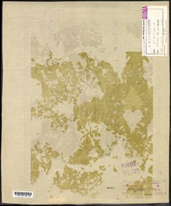
- Description:
- 1938
- Subject:
- Geographic Subject: Selikhovo, Topical Subject: Maps, and Topical Subject: Soviet Union
- Publisher:
- Главное управление геодезии и картографии при СНК СССР
- Language:
- Russian
- Date Created:
- 1941
- Identifier:
- VAC9619-003523
- Genre:
- Topographic Maps and Military Maps
- Geographic Location:
- Coordinates: 56.5, 36.75, 56.667, 37
- Related URL:
- Catalog URL: http://iucat.iu.edu/catalog/5020131 and Download GeoTIFF: https://drive.google.com/file/d/1rCotVjjaQLPnjUbK9attztcgGVRXarAQ/view?usp=sharing
- Abstract:
- Modern area represented: Селихово (Selikhovo), Tverskaya oblast, Russia
- Call Number:
- GM G7000 s50 .S68 sheet O-37-122-B
- City:
- Селехово (Selekhovo)
- Copyright Holder:
- No Copyright - United States
- Country:
- СССР (USSR)
- State/Province:
- Калининская область (Kalinin oblast), Клинский район (Klinsky district), Московская область (Moscow oblast), Конаковский район (Konakovsky district), and Зав...
- Physical Description:
- Scale: 1:50,000
- Persistent URL:
- http://purl.dlib.indiana.edu/iudl/images/VAC9619/VAC9619-003523
- Provenance:
- DMA Topographic Center, Army Map Service Library, OMAHA, Library of Congress Geography & Map Division
-
- Description:
- 1938
- Subject:
- Topical Subject: Maps, Geographic Subject: Konakovo, and Topical Subject: Soviet Union
- Publisher:
- Главное управление государственной съемки и картографии НКВД СССР
- Language:
- Russian
- Date Created:
- 1941
- Identifier:
- VAC9619-003522
- Genre:
- Topographic Maps and Military Maps
- Geographic Location:
- Coordinates: 56.667, 36.75, 56.833, 37
- Related URL:
- Download GeoTIFF: https://drive.google.com/file/d/113GolZU0LWI5CWw31Rws39j5ikise7Gi/view?usp=sharing and Catalog URL: http://iucat.iu.edu/catalog/5020131
- Abstract:
- Modern area represented: Конаково (Konakovo), Tverskaya oblast, Russia
- Call Number:
- GM G7000 s50 .S68 sheet O-37-110-D
- City:
- Конаково (Konakovo)
- Copyright Holder:
- No Copyright - United States
- Country:
- СССР (USSR)
- State/Province:
- Калининская область (Kalinin oblast), Оршинский район (Orshinsky district), Конаковский район (Konakovsky district), and Кимрский район (Kimrsky district)
- Physical Description:
- Scale: 1:50,000
- Persistent URL:
- http://purl.dlib.indiana.edu/iudl/images/VAC9619/VAC9619-003522
- Provenance:
- DMA Topographic Center, Army Map Service Library, OMAHA, Library of Congress Geography & Map Division
-
- Subject:
- Geographic Subject: Chernopenye, Topical Subject: Soviet Union, and Topical Subject: Maps
- Publisher:
- Центральное аэросъемочное производственное предприятие треста Аэрогеодезия
- Language:
- Russian
- Identifier:
- VAC9619-003521
- Genre:
- Topographic Maps and Military Maps
- Geographic Location:
- Coordinates: 57.5, 41, 57.667, 41.25
- Related URL:
- Catalog URL: http://iucat.iu.edu/catalog/5020131 and Download GeoTIFF: https://drive.google.com/file/d/1CbNxFdBQATCSF-pVZsCwyDuXH5qsSM5f/view?usp=sharing
- Abstract:
- Modern area represented: Chernopenye, Kostroma oblast, Russia
- Call Number:
- GM G7000 s50 .S68 sheet O-37-95-A
- City:
- Чернопенье (Chernopenye)
- Copyright Holder:
- No Copyright - United States
- Country:
- СССР (USSR)
- State/Province:
- РСФСР (RSFSR) and Ярославская область (Yaroslavl oblast)
- Physical Description:
- Scale: 1:50,000
- Persistent URL:
- http://purl.dlib.indiana.edu/iudl/images/VAC9619/VAC9619-003521
- Provenance:
- DMA Topographic Center, Army Map Service Library, OMAHA, Library of Congress Geography & Map Division
-
- Description:
- 1933
- Subject:
- Geographic Subject: Kosmynino, Topical Subject: Maps, and Topical Subject: Soviet Union
- Publisher:
- Центральное аэросъемочное производственное предприятие треста Аэрогеодезия
- Language:
- Russian
- Identifier:
- VAC9619-003520
- Genre:
- Military Maps and Topographic Maps
- Geographic Location:
- Coordinates: 57.5, 40.75, 57.667, 41
- Related URL:
- Download GeoTIFF: https://drive.google.com/file/d/1qR6BDVlq8CUzsCxPfiRsezxc0gx4jbsN/view?usp=sharing and Catalog URL: http://iucat.iu.edu/catalog/5020131
- Abstract:
- Modern area represented: Kosmynino, Kostroma oblast, Russia
- Call Number:
- GM G7000 s50 .S68 sheet O-37-94-B
- Caption:
- Не подлежит оглашению
- City:
- Косминино (Kosminino)
- Copyright Holder:
- No Copyright - United States
- Country:
- СССР (USSR)
- State/Province:
- Ивановская промышленная область (Ivanovo industrial oblast)
- Physical Description:
- Scale: 1:50,000
- Persistent URL:
- http://purl.dlib.indiana.edu/iudl/images/VAC9619/VAC9619-003520
- Provenance:
- DMA Topographic Center, Army Map Service Library, OMAHA, Library of Congress Geography & Map Division
